Enable Location

We need your location to show you interesting places around you

Discover nearby places

Find interesting locations and hidden gems around you

Precise directions

Get accurate directions and distances to places

Your location is never shared with other users. It's only used when you tap the location button.

Wigwam Motel

Log in to your account

Start exploring — it's free

Trusted by 61,910 travelers worldwide

Continue with Google
Continue with Apple
or

We will send you a code to connect

By continuing, you accept our Terms and Conditions and our Privacy Policy

Check your inbox

We've sent a pincode in your inbox. Please enter the code below.

Wigwam Motel

Wigwam Motel, Native American-style tepee lodging along Route 66 in Holbrook, Arizona.

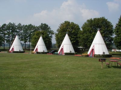
The Wigwam Motel is a Route 66 lodging in Holbrook consisting of fifteen concrete tepee structures arranged in a semi-circular formation. Each unit features a bathroom, television, air conditioning, and a parking space with furnishings that reflect mid-century style.

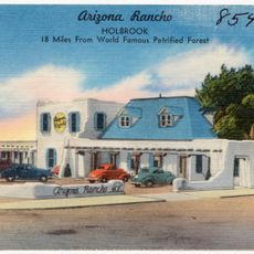
This motel was founded in 1950 by Chester Lewis and followed a design concept that Frank Redford had originally patented in Kentucky. It was part of a chain of similar lodgings that changed how people traveled along Route 66.

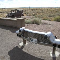
This lodging reflects the Route 66 roadside culture of the mid-twentieth century and maintains its original design with a large collection of vintage cars on display. Visitors can see how the automobile culture of that era shaped travel and leisure along this famous highway.

This lodging is easily accessible and provides parking right at your unit. Guests should expect basic but functional accommodations that work best during milder seasons.

Each concrete tepee measures approximately 21 feet wide and 28 feet tall and is painted with southwestern patterns and colors. This unusual lodging form was novel in the 1950s and has become a photographer's favorite along the highway.

The community of curious travelers

AroundUs brings together thousands of curated places, local tips, and hidden gems, enriched daily by 60,000 contributors worldwide.

Start exploring
GPS coordinates
34.90224,-110.16827
Latest update
December 14, 2025 20:46
Around this place
Chevelon Creek Bridge
United States of America

Chevelon Creek Bridge

33 km
Painted Desert Inn
United States of America

Painted Desert Inn

40.1 km
Agate House Pueblo
United States of America

Agate House Pueblo

30 km
Newspaper Rock Petroglyphs Archeological District
United States of America

Newspaper Rock Petroglyphs Archeological District

34.3 km
Arizona Rancho
United States of America

Arizona Rancho

665 m
Puerco Ruin and Petroglyphs
United States of America

Puerco Ruin and Petroglyphs

35.1 km
Painted Desert Community Complex Historic District
United States of America

Painted Desert Community Complex Historic District

39.9 km
Rainbow Forest Museum
United States of America

Rainbow Forest Museum

29.3 km
Agate Bridge
United States of America

Agate Bridge

34.2 km
Jasper Forest
United States of America

Jasper Forest

32.9 km
Rainbow Forest
United States of America

Rainbow Forest

28.6 km
Crystal Forest
United States of America

Crystal Forest

35.2 km
Giant Logs Trail
United States of America

Giant Logs Trail

29.2 km
Petrified Forest National Wilderness Area
United States of America

Petrified Forest National Wilderness Area

41.2 km
Chinde Point
United States of America

Chinde Point

39.7 km
The Tepees South Pullout
United States of America

The Tepees South Pullout

36.1 km
Tiponi Point
United States of America

Tiponi Point

40.1 km
Jasper Forest Viewpoint
United States of America

Jasper Forest Viewpoint

33 km
Painted Desert Visitor Center
United States of America

Painted Desert Visitor Center

39.7 km
Blue Mesa Trail
United States of America

Blue Mesa Trail

37.5 km
Whipple Point
United States of America

Whipple Point

38.5 km
Tawa Point
United States of America

Tawa Point

40.4 km
Route 66 Pullout
United States of America

Route 66 Pullout

37 km
Giant Logs
United States of America

Giant Logs

29.2 km
Lacey Point
United States of America

Lacey Point

37.9 km
Obed Road Bridge
United States of America

Obed Road Bridge

14.9 km
Rainbow Forest Complex
United States of America

Rainbow Forest Complex

29.3 km
The Tepees North Pullout
United States of America

The Tepees North Pullout

36.1 km
Show the full map
« Wigwam Motel - Native American-style tepee lodging along Route 66 in Holbrook, Arizona » is provided by Around Us (aroundus.com). Images and texts are derived from Wikimedia project under a Creative Commons license. You are allowed to copy, distribute, and modify copies of this page, under the conditions set by the license, as long as this note is clearly visible.

Discover hidden gems everywhere you go!

From secret cafés to breathtaking viewpoints, skip the crowded tourist spots and find places that match your style. Our app makes it easy with voice search, smart filtering, route optimization, and insider tips from travelers worldwide. Download now for the complete mobile experience.

Around Us App Screenshot

A unique approach to discovering new places

Le Figaro

All the places worth exploring

France Info

A tailor-made excursion in just a few clicks

20 Minutes

Around Us
Travel Guide & Maps
Download

Send to your phone

QR Code
1

Open the camera app on your mobile.

2

Point at the QR code with your camera. A notification will appear.

3

Tap the notification to open the link.