Enable Location

We need your location to show you interesting places around you

Discover nearby places

Find interesting locations and hidden gems around you

Precise directions

Get accurate directions and distances to places

Your location is never shared with other users. It's only used when you tap the location button.

Arizona Rancho

Log in to your account

Start exploring — it's free

Trusted by 62,459 travelers worldwide

Continue with Google
Continue with Apple
or

We will send you a code to connect

By continuing, you accept our Terms and Conditions and our Privacy Policy

Check your inbox

We've sent a pincode in your inbox. Please enter the code below.

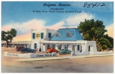
Arizona Rancho, United States historic place

The Arizona Rancho is a historic building in Holbrook, also known as the Higgins House or Brunswick Hotel, featuring Pueblo Revival style with thick adobe walls and pitched roofs. The structure reflects multiple expansions since the 1880s, combining adobe bricks, wood, and stone materials into a complex ensemble.

Pedro Montano built the Arizona Rancho around the early 1880s as a simple home with thick adobe walls. The building evolved from a private residence to a boarding house and later a hotel, served as a hospital during the 1930s, and housed Navy pilot trainees during World War II.

The Arizona Rancho shows the mixed heritage of settlers who shaped Holbrook. The building displays a blend of Hispanic and American construction methods in its thick adobe walls and steep rooflines, marking the early settlement period.

The building sits on West Alvorado Drive and displays weathered walls requiring a slower pace to explore. Visitors should know that only the exterior is accessible and interior viewing is not possible, so plan accordingly for photographs and external inspection.

The building once served as a gathering point for different communities, hosting dance events, a Masonic lodge, and even a Navy pilot training center during wartime. These varied functions show how adaptable the structure was and how central it remained to the community across different historical moments.

The community of curious travelers

AroundUs brings together thousands of curated places, local tips, and hidden gems, enriched daily by 60,000 contributors worldwide.

Start exploring
Location
Inception
1881
Architectural style
Pueblo Revival Style architecture
GPS coordinates
34.89953,-110.16178
Latest update
February 9, 2026 08:20
Around this place
Wigwam Motel
United States of America

Wigwam Motel

665 m
Chevelon Creek Bridge
United States of America

Chevelon Creek Bridge

33.7 km
Painted Desert Inn
United States of America

Painted Desert Inn

39.8 km
Snowflake Arizona Temple
United States of America

Snowflake Arizona Temple

44.5 km
Agate House Pueblo
United States of America

Agate House Pueblo

29.4 km
Newspaper Rock Petroglyphs Archeological District
United States of America

Newspaper Rock Petroglyphs Archeological District

33.8 km
Puerco Ruin and Petroglyphs
United States of America

Puerco Ruin and Petroglyphs

34.6 km
Painted Desert Community Complex Historic District
United States of America

Painted Desert Community Complex Historic District

39.5 km
Rainbow Forest Museum
United States of America

Rainbow Forest Museum

28.6 km
Agate Bridge
United States of America

Agate Bridge

33.6 km
Jasper Forest
United States of America

Jasper Forest

32.3 km
Rainbow Forest
United States of America

Rainbow Forest

27.9 km
Crystal Forest
United States of America

Crystal Forest

34.6 km
Giant Logs Trail
United States of America

Giant Logs Trail

28.5 km
Petrified Forest National Wilderness Area
United States of America

Petrified Forest National Wilderness Area

40.9 km
Chinde Point
United States of America

Chinde Point

39.3 km
Tiponi Point
United States of America

Tiponi Point

39.8 km
Jasper Forest Viewpoint
United States of America

Jasper Forest Viewpoint

32.4 km
Painted Desert Visitor Center
United States of America

Painted Desert Visitor Center

39.3 km
Blue Mesa Trail
United States of America

Blue Mesa Trail

36.9 km
Whipple Point
United States of America

Whipple Point

38.1 km
Tawa Point
United States of America

Tawa Point

40 km
Route 66 Pullout
United States of America

Route 66 Pullout

36.6 km
Giant Logs
United States of America

Giant Logs

28.6 km
Lacey Point
United States of America

Lacey Point

37.5 km
Obed Road Bridge
United States of America

Obed Road Bridge

15.5 km
Rainbow Forest Complex
United States of America

Rainbow Forest Complex

28.6 km
The Tepees North Pullout
United States of America

The Tepees North Pullout

35.5 km
Show the full map
« Arizona Rancho - United States historic place » is provided by Around Us (aroundus.com). Images and texts are derived from Wikimedia project under a Creative Commons license. You are allowed to copy, distribute, and modify copies of this page, under the conditions set by the license, as long as this note is clearly visible.

Discover hidden gems everywhere you go!

From secret cafés to breathtaking viewpoints, skip the crowded tourist spots and find places that match your style. Our app makes it easy with voice search, smart filtering, route optimization, and insider tips from travelers worldwide. Download now for the complete mobile experience.

Around Us App Screenshot

A unique approach to discovering new places

Le Figaro

All the places worth exploring

France Info

A tailor-made excursion in just a few clicks

20 Minutes

Around Us
Travel Guide & Maps
Download

Send to your phone

QR Code
1

Open the camera app on your mobile.

2

Point at the QR code with your camera. A notification will appear.

3

Tap the notification to open the link.