Enable Location

We need your location to show you interesting places around you

Discover nearby places

Find interesting locations and hidden gems around you

Precise directions

Get accurate directions and distances to places

Your location is never shared with other users. It's only used when you tap the location button.

Chevelon Creek Bridge

Log in to your account

Start exploring — it's free

Trusted by 61,553 travelers worldwide

Continue with Google
Continue with Apple
or

We will send you a code to connect

By continuing, you accept our Terms and Conditions and our Privacy Policy

Check your inbox

We've sent a pincode in your inbox. Please enter the code below.

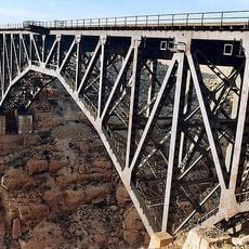
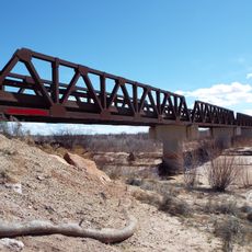
Chevelon Creek Bridge, Steel truss bridge near Winslow, United States

Description

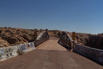
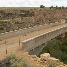
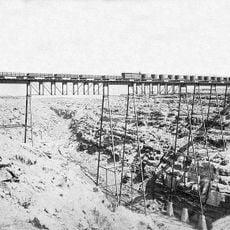
Chevelon Creek Bridge is a steel truss bridge in Navajo County that spans a deep canyon with original riveted construction. The structure measures about 102 feet long and rises approximately 90 feet above the creek's water level.

History

The bridge was built in 1912 by Missouri Valley Bridge & Iron Works shortly after Arizona achieved statehood as part of an early road project. The structure has stood since then, marking a turning point in how traffic moved through this remote region.

Culture

The bridge once served as a vital link on the Santa Fe Highway, an early national route that shaped regional commerce and travel patterns. Travelers passing through this landscape today can trace the path that connected distant parts of the country.

Practical

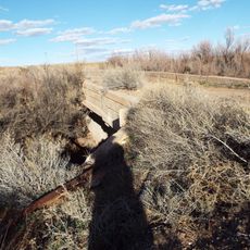
The bridge is located roughly 12 miles southeast of Winslow and is accessible by local roads through a rural area. Visitors should be prepared for remote terrain and variable weather conditions typical of northern Arizona's high elevation.

Did you know?

The structure retains its original riveted construction and underwent major restoration in 2013 when concrete abutments were completely reconstructed. This work demonstrates how early 20th-century engineering can be carefully preserved and renewed for another generation.
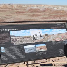
Location
GPS coordinates
34.92321,-110.52929
Latest update
December 7, 2025 19:30

AroundUs brings together thousands of curated places, local tips, and hidden gems, enriched daily by 60,000 contributors worldwide. Discover all places nearby (Navajo County).

Around this place
Meteor Crater
United States of America

Meteor Crater

46.6 km
Standin' on the Corner Park
United States of America

Standin' on the Corner Park

19 km
Wigwam Motel
United States of America

Wigwam Motel

33 km
Canyon Diablo meteorite
United States of America

Canyon Diablo meteorite

48.1 km
Meteor Crater Natural Landmark
United States of America

Meteor Crater Natural Landmark

46.4 km
Homolovi State Park
United States of America

Homolovi State Park

14.6 km
Meteor Crater Visitor Center
United States of America

Meteor Crater Visitor Center

46.5 km
Canyon Diablo Bridge
United States of America

Canyon Diablo Bridge

55.9 km
Snowflake Arizona Temple
United States of America

Snowflake Arizona Temple

60.5 km
Meteor City, Arizona
United States of America

Meteor City, Arizona

41.7 km
La Posada Historic District
United States of America

La Posada Historic District

18.7 km
Brigham City
United States of America

Brigham City

19.4 km
Agate House Pueblo
United States of America

Agate House Pueblo

62.4 km
Newspaper Rock Petroglyphs Archeological District
United States of America

Newspaper Rock Petroglyphs Archeological District

66.8 km
Arizona Rancho
United States of America

Arizona Rancho

33.7 km
Lorenzo Hubbell Trading Post and Warehouse
United States of America

Lorenzo Hubbell Trading Post and Warehouse

19.5 km
Rainbow Forest Museum
United States of America

Rainbow Forest Museum

61.8 km
Jasper Forest
United States of America

Jasper Forest

65.9 km
Rainbow Forest
United States of America

Rainbow Forest

61 km
Giant Logs Trail
United States of America

Giant Logs Trail

61.7 km
American Astronaut Wall of Fame
United States of America

American Astronaut Wall of Fame

46.5 km
Jasper Forest Viewpoint
United States of America

Jasper Forest Viewpoint

66 km
Canyon Diablo Bridge (1946)
United States of America

Canyon Diablo Bridge (1946)

60.9 km
Giant Logs
United States of America

Giant Logs

61.7 km
Obed Road Bridge
United States of America

Obed Road Bridge

18.9 km
Canyon Diablo Railroad Trestle Bridge (1882)
United States of America

Canyon Diablo Railroad Trestle Bridge (1882)

60.9 km
Rainbow Forest Complex
United States of America

Rainbow Forest Complex

61.8 km
Holbrook Bridge
United States of America

Holbrook Bridge

38.6 km
Show the full map
« Chevelon Creek Bridge - Steel truss bridge near Winslow, United States » is provided by Around Us (aroundus.com). Images and texts are derived from Wikimedia project under a Creative Commons license. You are allowed to copy, distribute, and modify copies of this page, under the conditions set by the license, as long as this note is clearly visible.

Discover hidden gems everywhere you go!

From secret cafés to breathtaking viewpoints, skip the crowded tourist spots and find places that match your style. Our app makes it easy with voice search, smart filtering, route optimization, and insider tips from travelers worldwide. Download now for the complete mobile experience.

Around Us App Screenshot

A unique approach to discovering new places

Le Figaro

All the places worth exploring

France Info

A tailor-made excursion in just a few clicks

20 Minutes

Around Us
Travel Guide & Maps
Download

Send to your phone

QR Code
1

Open the camera app on your mobile.

2

Point at the QR code with your camera. A notification will appear.

3

Tap the notification to open the link.