Enable Location

We need your location to show you interesting places around you

Discover nearby places

Find interesting locations and hidden gems around you

Precise directions

Get accurate directions and distances to places

Your location is never shared with other users. It's only used when you tap the location button.

Meteor City, Arizona

Log in to your account

Start exploring — it's free

Trusted by 61,921 travelers worldwide

Continue with Google
Continue with Apple
or

We will send you a code to connect

By continuing, you accept our Terms and Conditions and our Privacy Policy

Check your inbox

We've sent a pincode in your inbox. Please enter the code below.

Meteor City, Arizona

Meteor City, Arizona, Trading post on Route 66 in Arizona, United States

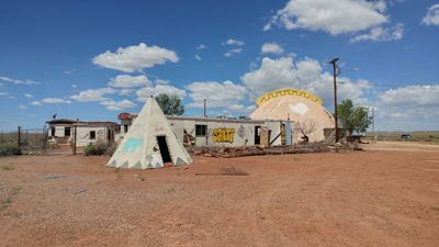
Meteor City is a trading post along Interstate 40 in Arizona, recognized by its distinctive geodesic dome structure. The site contains an abandoned curio shop and historical exhibits that document the Route 66 era.

The site opened in 1938 as Sharber Service Station under the Texaco brand and later evolved into a trading post. This shift from a gas station to a souvenir destination reflected changing travel patterns along the major highway route.

The property displayed an extensive hand-painted Route 66 map created by artist Bob Waldmire, stretching across wooden panels that became a focal point for travelers. This artistic installation gave the place a distinctive character tied to the road's cultural heritage and attracted visitors interested in roadside art.

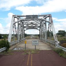
The site is accessible from Interstate 40 by taking Exit 239, which is located between the communities of Winslow and Flagstaff. The location sits at a convenient stopping point for travelers moving between these two areas.

The site once featured a sign reading 'Population: 1,' which changed to 'Population: 2' when the owner married his partner Gloria. This playful and personal touch from the owner became a recognizable feature of the place and reflected the personality behind this Route 66 stop.

The community of curious travelers

AroundUs brings together thousands of curated places, local tips, and hidden gems, enriched daily by 60,000 contributors worldwide.

Start exploring
Location
Elevation above the sea
1,534 m
GPS coordinates
35.09444,-110.93556
Latest update
December 8, 2025 21:01
Around this place
Meteor Crater
United States of America

Meteor Crater

10.9 km
Standin' on the Corner Park
United States of America

Standin' on the Corner Park

23 km
Roden Crater
United States of America

Roden Crater

47.2 km
Canyon Diablo meteorite
United States of America

Canyon Diablo meteorite

10.2 km
Grand Falls
United States of America

Grand Falls

44.3 km
Chevelon Creek Bridge
United States of America

Chevelon Creek Bridge

41.7 km
Meteor Crater Natural Landmark
United States of America

Meteor Crater Natural Landmark

10.8 km
Canyon Diablo
United States of America

Canyon Diablo

23 km
Homolovi State Park
United States of America

Homolovi State Park

29 km
Discovery Channel Telescope
United States of America

Discovery Channel Telescope

59.1 km
Meteor Crater Visitor Center
United States of America

Meteor Crater Visitor Center

10.4 km
Canyon Diablo Bridge
United States of America

Canyon Diablo Bridge

14.8 km
Elden Pueblo
United States of America

Elden Pueblo

59.9 km
La Posada Historic District
United States of America

La Posada Historic District

23.4 km
Lenox Crater
United States of America

Lenox Crater

61.6 km
Lorenzo Hubbell Trading Post and Warehouse
United States of America

Lorenzo Hubbell Trading Post and Warehouse

22.5 km
Cliffs Ranger Station
United States of America

Cliffs Ranger Station

53.9 km
Wupatki Pueblo
United States of America

Wupatki Pueblo

61.9 km
Wukoki Pueblo
United States of America

Wukoki Pueblo

60.3 km
Walnut Canyon Visitor Center
United States of America

Walnut Canyon Visitor Center

53 km
American Astronaut Wall of Fame
United States of America

American Astronaut Wall of Fame

10.4 km
Wupatki Pueblo Ball Court
United States of America

Wupatki Pueblo Ball Court

62 km
Canyon Diablo Bridge (1946)
United States of America

Canyon Diablo Bridge (1946)

19.2 km
Moqui Lookout
United States of America

Moqui Lookout

62.7 km
Obed Road Bridge
United States of America

Obed Road Bridge

58.3 km
Canyon Diablo Railroad Trestle Bridge (1882)
United States of America

Canyon Diablo Railroad Trestle Bridge (1882)

19.2 km
Winona Bridge
United States of America

Winona Bridge

46.1 km
Old Jack's Canyon Bridge
United States of America

Old Jack's Canyon Bridge

28.9 km
Show the full map
« Meteor City, Arizona - Trading post on Route 66 in Arizona, United States » is provided by Around Us (aroundus.com). Images and texts are derived from Wikimedia project under a Creative Commons license. You are allowed to copy, distribute, and modify copies of this page, under the conditions set by the license, as long as this note is clearly visible.

Discover hidden gems everywhere you go!

From secret cafés to breathtaking viewpoints, skip the crowded tourist spots and find places that match your style. Our app makes it easy with voice search, smart filtering, route optimization, and insider tips from travelers worldwide. Download now for the complete mobile experience.

Around Us App Screenshot

A unique approach to discovering new places

Le Figaro

All the places worth exploring

France Info

A tailor-made excursion in just a few clicks

20 Minutes

Around Us
Travel Guide & Maps
Download

Send to your phone

QR Code
1

Open the camera app on your mobile.

2

Point at the QR code with your camera. A notification will appear.

3

Tap the notification to open the link.