Meteor Crater

Log in to your account

AroundUs is a community-driven map of interesting places, built by curious explorers like you. It grows with every review, story, and photo you share.
Connect to save your favorite spots, contribute locations, and create personalized routes.
Continue with Google
Continue with Apple
Continue with X
Continue with Facebook
Continue with email
By continuing, you accept our Terms and Conditions and our Privacy Policy
Create an account
Add to collection
Map
Suggest a change
Share

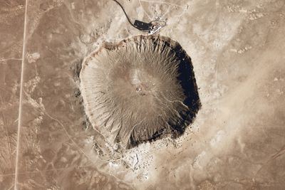
Meteor Crater, Impact crater in Coconino County, Arizona, United States.

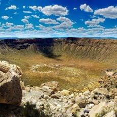
Meteor Crater is a near-circular depression in northeastern Arizona that spans roughly 1.2 kilometers (three quarters of a mile) across and drops about 170 meters (550 feet) at its deepest point. The rim rises roughly 45 meters (150 feet) above the surrounding desert floor, forming a raised wall of fractured rock visible from a distance.

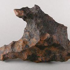
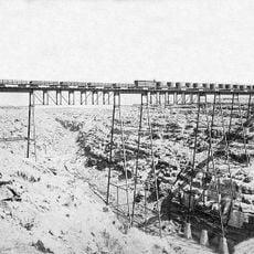
The depression formed roughly 50,000 years ago when an iron meteorite about 50 meters (160 feet) wide struck the ground at tremendous speed. For many years, scientists believed the formation was an extinct volcano until an engineer in the early 1900s discovered fragments of meteorite scattered around the area and proved its true origin.

Visitors often arrive with a sense of wonder about Earth's relationship with the solar system, treating the site as a place where ordinary people can grasp the scale of cosmic events. Local families and science enthusiasts from around the country return regularly, drawn by the tangible connection to forces beyond our planet.

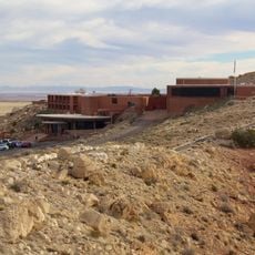
A visitor center near the rim offers exhibits on meteorites and space exploration, while guided walks along the edge help visitors understand the scale of the impact. Those exploring the rim should wear sturdy shoes, as the terrain is uneven and the desert sun can be intense throughout the day.

The force of the impact threw millions of tons of rock into the air, scattering fragments across a wide area far beyond the rim itself. Astronauts from the Apollo program trained here during the 1960s because the landscape resembles the surface of the moon.

Location: Coconino County

Elevation above the sea: 1,719 m

Website: https://meteorcrater.com

GPS coordinates: 35.02806,-111.02333

Latest update: December 15, 2025 00:21

Photos
National parks and monuments in Southwestern US

The southwestern United States encompasses desert landscapes, sandstone formations and archaeological sites from several pre-Columbian cultures. The region spans Utah, Arizona, New Mexico and Colorado, featuring geological structures shaped over millions of years by wind and water erosion. National...

Meteorite craters on Earth

Meteorite impact craters are scars on Earth's surface created when asteroids collided with our planet. These geological structures range from 110 meters to 300 kilometers in diameter and tell stories spanning millions of years. The collision created extreme heat and pressure, forging rare minerals...

Around this place
Standin' on the Corner Park
United States of America

Standin' on the Corner Park

29.7 km
Canyon Diablo meteorite
United States of America

Canyon Diablo meteorite

2.6 km
Meteor Crater Natural Landmark
United States of America

Meteor Crater Natural Landmark

109 m
Canyon Diablo
United States of America

Canyon Diablo

30 km
Meteor Crater Visitor Center
United States of America

Meteor Crater Visitor Center

585 m
Canyon Diablo Bridge
United States of America

Canyon Diablo Bridge

11.8 km
Meteor City, Arizona
United States of America

Meteor City, Arizona

10.9 km
La Posada Historic District
United States of America

La Posada Historic District

30 km
Brigham City
United States of America

Brigham City

31 km
United States of America

Coconino Reservoir

34.4 km
Lorenzo Hubbell Trading Post and Warehouse
United States of America

Lorenzo Hubbell Trading Post and Warehouse

29.2 km
American Astronaut Wall of Fame
United States of America

American Astronaut Wall of Fame

582 m
United States of America

Relic Point

31.7 km
Canyon Diablo Bridge (1946)
United States of America

Canyon Diablo Bridge (1946)

18.1 km
Canyon Diablo Railroad Trestle Bridge (1882)
United States of America

Canyon Diablo Railroad Trestle Bridge (1882)

18.1 km
Old Jack's Canyon Bridge
United States of America

Old Jack's Canyon Bridge

34.2 km
United States of America

Gorge

18.1 km
United States of America

Twin Arrows

27.7 km
United States of America

Astronaut Statue

66 m
United States of America

Work of art, sculpture

29.3 km
United States of America

Scenic viewpoint

493 m
United States of America

Scenic viewpoint

489 m
United States of America

Scenic viewpoint

460 m
United States of America

Scenic viewpoint

34.3 km
United States of America

Scenic viewpoint

34.3 km
United States of America

Scenic viewpoint

32.8 km
United States of America

Scenic viewpoint

489 m
United States of America

Scenic viewpoint

556 m
Show the full map
Reviews

Visited this place? Tap the stars to rate it and share your experience / photos with the community! Try now! You can cancel it anytime.

« Meteor Crater - Impact crater in Coconino County, Arizona, United States » is provided by Around Us (aroundus.com). Images and texts are derived from Wikimedia project under a Creative Commons license. You are allowed to copy, distribute, and modify copies of this page, under the conditions set by the license, as long as this note is clearly visible.

Discover hidden gems everywhere you go!

From secret cafés to breathtaking viewpoints, skip the crowded tourist spots and find places that match your style. Our app makes it easy with voice search, smart filtering, route optimization, and insider tips from travelers worldwide. Download now for the complete mobile experience.

Around Us App Screenshot

A unique approach to discovering new places

Le Figaro

All the places worth exploring

France Info

A tailor-made excursion in just a few clicks

20 Minutes