Enable Location

We need your location to show you interesting places around you

Discover nearby places

Find interesting locations and hidden gems around you

Precise directions

Get accurate directions and distances to places

Your location is never shared with other users. It's only used when you tap the location button.

Devil's Gate-Weber Hydroelectric Power Plant

Log in to your account

Start exploring — it's free

Trusted by travelers worldwide

Continue with Google
Continue with Apple
or

We will send you a code to connect

By continuing, you accept our Terms and Conditions and our Privacy Policy

Check your inbox

We've sent a pincode in your inbox. Please enter the code below.

Devil's Gate-Weber Hydroelectric Power Plant

Devil's Gate-Weber Hydroelectric Power Plant, Hydroelectric power plant district in Weber Canyon, US.

Description

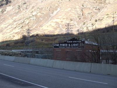
The Devil's Gate-Weber Hydroelectric Power Plant is a historic electricity facility in Weber Canyon, built with a brick powerhouse topped by a concrete roof and steel trusses. The system channels water several miles from an upstream dam and uses turbines to convert flowing water into electrical power.

History

The facility was built in 1910 by Utah Light and Railway Company and ranked among the first power plants to connect to an electrical grid in Utah. The project became central to electrifying the region and powering surrounding communities and railway operations.

Culture

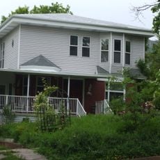
Four families made their homes at the site and shaped daily life around the river and nearby railway lines. The settlement grew as its own community, driven by the rhythm of power generation work.

Practical

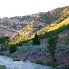
The site sits in a canyon with limited road access, so exploring on foot helps you see the structures and their surroundings clearly. The best time to visit is on days with good visibility when you can view the buildings and landscape from multiple vantage points.

Did you know?

The power plant spreads across two counties, with the powerhouse in Weber County while the dam reaches into Morgan County. This is an unusual example of infrastructure intentionally crossing administrative boundaries.

Location
Location
GPS coordinates
41.13758,-111.88472
Latest update
December 14, 2025 11:20

AroundUs brings together thousands of curated places, local tips, and hidden gems, enriched daily by 60,000 contributors worldwide. Discover all places nearby (Weber County).

Around this place
United States of America

Kay's Cross

10.2 km
Weber Canyon
United States of America

Weber Canyon

1.6 km
Mount Ogden
United States of America

Mount Ogden

6.9 km
John Moses Browning House
United States of America

John Moses Browning House

11.1 km
Gustav Becker House
United States of America

Gustav Becker House

10.9 km
Eccles Avenue Historic District
United States of America

Eccles Avenue Historic District

10.7 km
United States of America

Ott Planetarium

7.9 km
Tepanyaki
United States of America

Tepanyaki

10.4 km
Congregation Montefiore Synagogue
United States of America

Congregation Montefiore Synagogue

11.2 km
Hillcrest Apartments
United States of America

Hillcrest Apartments

11.2 km
Davis Lanes
United States of America

Davis Lanes

10.8 km
Farmer's Union Building
United States of America

Farmer's Union Building

10.9 km
Joseph Adams House
United States of America

Joseph Adams House

9.5 km
Bertha Eccles Community Art Center
United States of America

Bertha Eccles Community Art Center

11.2 km
Dennis A. Smyth House
United States of America

Dennis A. Smyth House

11.3 km
Browning Apartments
United States of America

Browning Apartments

11.3 km
Avon Apartments
United States of America

Avon Apartments

10.9 km
Ladywood Apartments
United States of America

Ladywood Apartments

11.1 km
Heber Scowcroft House
United States of America

Heber Scowcroft House

11.2 km
Avelan Apartments
United States of America

Avelan Apartments

11.2 km
Andrew J. Warner House
United States of America

Andrew J. Warner House

11.2 km
Flowers Apartments
United States of America

Flowers Apartments

11 km
Fontenelle Apartments
United States of America

Fontenelle Apartments

11.2 km
John L. and Elizabeth Dalton House
United States of America

John L. and Elizabeth Dalton House

11 km
La Frantz Apartments
United States of America

La Frantz Apartments

11.2 km
McGregor Apartments
United States of America

McGregor Apartments

11.2 km
Classic Waterslides
United States of America

Classic Waterslides

10.1 km
Augustus B. Patton House
United States of America

Augustus B. Patton House

10.5 km
Show the full map
« Devil's Gate-Weber Hydroelectric Power Plant - Hydroelectric power plant district in Weber Canyon, US » is provided by Around Us (aroundus.com). Images and texts are derived from Wikimedia project under a Creative Commons license. You are allowed to copy, distribute, and modify copies of this page, under the conditions set by the license, as long as this note is clearly visible.

Discover hidden gems everywhere you go!

From secret cafés to breathtaking viewpoints, skip the crowded tourist spots and find places that match your style. Our app makes it easy with voice search, smart filtering, route optimization, and insider tips from travelers worldwide. Download now for the complete mobile experience.

Around Us App Screenshot

A unique approach to discovering new places

Le Figaro

All the places worth exploring

France Info

A tailor-made excursion in just a few clicks

20 Minutes

Around Us
Travel Guide & Maps
Download

Send to your phone

QR Code
1

Open the camera app on your mobile.

2

Point at the QR code with your camera. A notification will appear.

3

Tap the notification to open the link.