Enable Location

We need your location to show you interesting places around you

Discover nearby places

Find interesting locations and hidden gems around you

Precise directions

Get accurate directions and distances to places

Your location is never shared with other users. It's only used when you tap the location button.

Weber Canyon

Log in to your account

Start exploring — it's free

Trusted by 65,441 travelers worldwide

Continue with Google
Continue with Apple
or

We will send you a code to connect

By continuing, you accept our Terms and Conditions and our Privacy Policy

Check your inbox

We've sent a pincode in your inbox. Please enter the code below.

Weber Canyon
Discussion Reviews 1 Photos
6.9k Popularity

Weber Canyon, Canyon in Wasatch Range, Utah, United States

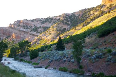
Weber Canyon is a gorge in the Wasatch Range in Utah, carved by the Weber River as it flows west toward the Great Salt Lake. The canyon walls rise steeply on both sides, with forests, side streams, and reservoirs spread along its length.

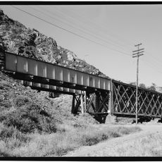
Shoshone and Ute peoples camped and traveled through the valley long before European explorers arrived, using the Weber River tributaries as reliable water sources. In the 1800s, the canyon became a key passage for fur traders, pioneers heading west, and eventually the first transcontinental railroad.

The canyon takes its name from John Henry Weber, a fur trapper who passed through the area in the early 1800s. Travelers driving or walking through today are following a corridor that people have used for centuries, long before roads were built here.

Interstate 84 runs through the canyon, making it straightforward to reach by car from several directions. Campgrounds and hiking trails are available along the route, so it helps to decide in advance whether you want to camp, hike, or simply drive through.

Along the old overland route through the canyon stands the Thousand Mile Tree, a pine marking the point exactly 1,000 miles (about 1,600 km) from Omaha along the original trail. The tree standing there today was planted in 1982, because the original marker used by 19th-century travelers no longer exists.

The community of curious travelers

AroundUs brings together thousands of curated places, local tips, and hidden gems, enriched daily by 60,000 contributors worldwide.

Start exploring
Location
Location
Location
Elevation above the sea
1,391 m
GPS coordinates
41.13580,-111.90400
Latest update
March 3, 2026 10:10
Around this place
United States of America

Kay's Cross

9.6 km
Hill Aerospace Museum
United States of America

Hill Aerospace Museum

10.1 km
Mount Ogden
United States of America

Mount Ogden

7.4 km
John Moses Browning House
United States of America

John Moses Browning House

10.4 km
Gustav Becker House
United States of America

Gustav Becker House

10.4 km
Devil's Gate-Weber Hydroelectric Power Plant
United States of America

Devil's Gate-Weber Hydroelectric Power Plant

1.6 km
Eccles Avenue Historic District
United States of America

Eccles Avenue Historic District

10.1 km
United States of America

Ott Planetarium

7.2 km
Jefferson Avenue Historic District
United States of America

Jefferson Avenue Historic District

10.6 km
Tepanyaki
United States of America

Tepanyaki

8.8 km
Congregation Montefiore Synagogue
United States of America

Congregation Montefiore Synagogue

10.2 km
Hillcrest Apartments
United States of America

Hillcrest Apartments

10.5 km
Joseph Adams House
United States of America

Joseph Adams House

8.6 km
Bertha Eccles Community Art Center
United States of America

Bertha Eccles Community Art Center

10.5 km
Browning Apartments
United States of America

Browning Apartments

10.5 km
Avon Apartments
United States of America

Avon Apartments

10.3 km
John Henry Layton House
United States of America

John Henry Layton House

10.5 km
Ladywood Apartments
United States of America

Ladywood Apartments

10.4 km
Heber Scowcroft House
United States of America

Heber Scowcroft House

10.6 km
Avelan Apartments
United States of America

Avelan Apartments

10.5 km
Andrew J. Warner House
United States of America

Andrew J. Warner House

10.6 km
Flowers Apartments
United States of America

Flowers Apartments

10.3 km
Fontenelle Apartments
United States of America

Fontenelle Apartments

10.6 km
John L. and Elizabeth Dalton House
United States of America

John L. and Elizabeth Dalton House

10.3 km
La Frantz Apartments
United States of America

La Frantz Apartments

10.5 km
McGregor Apartments
United States of America

McGregor Apartments

10.5 km
Augustus B. Patton House
United States of America

Augustus B. Patton House

10.1 km
Devil's Gate Bridge
United States of America

Devil's Gate Bridge

3.7 km
Show the full map
Reviews
Share your experience

No review yet

Discussions
Start a discussion...

No discussion yet

« Weber Canyon - Canyon in Wasatch Range, Utah, United States » is provided by Around Us (aroundus.com). Images and texts are derived from Wikimedia project under a Creative Commons license. You are allowed to copy, distribute, and modify copies of this page, under the conditions set by the license, as long as this note is clearly visible.

Discover hidden gems everywhere you go!

From secret cafés to breathtaking viewpoints, skip the crowded tourist spots and find places that match your style. Our app makes it easy with voice search, smart filtering, route optimization, and insider tips from travelers worldwide. Download now for the complete mobile experience.

Around Us App Screenshot

A unique approach to discovering new places

Le Figaro

All the places worth exploring

France Info

A tailor-made excursion in just a few clicks

20 Minutes

Around Us
Travel Guide & Maps
Download

Send to your phone

QR Code
1

Open the camera app on your mobile.

2

Point at the QR code with your camera. A notification will appear.

3

Tap the notification to open the link.