Enable Location

We need your location to show you interesting places around you

Discover nearby places

Find interesting locations and hidden gems around you

Precise directions

Get accurate directions and distances to places

Your location is never shared with other users. It's only used when you tap the location button.

Hawikuh Ruins

Log in to your account

Start exploring — it's free

Trusted by 61,953 travelers worldwide

Continue with Google
Continue with Apple
or

We will send you a code to connect

By continuing, you accept our Terms and Conditions and our Privacy Policy

Check your inbox

We've sent a pincode in your inbox. Please enter the code below.

Hawikuh Ruins

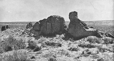
Hawikuh Ruins, Archaeological site in Zuni, New Mexico, United States

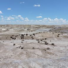
Hawikuh Ruins are the remains of a pueblo settlement built from six large structures connected by passageways and surrounding open plazas. Stone foundations and wall fragments show how the community was laid out and where hundreds of residents once moved through daily life.

The settlement grew and thrived for centuries before Spanish arrival in 1540, when conquistadors entered and claimed the pueblo as their first stronghold in the region. This encounter transformed the pueblo's trajectory from an independent community into one under colonial control.

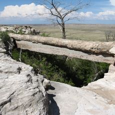
The site shows how the Zuni built their homes using local sandstone and arranged living spaces around central gathering areas. The way rooms connect to one another reveals daily rhythms and how families organized their community life.

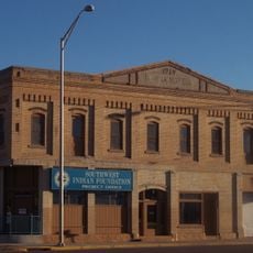
The site sits on the Zuni Indian Reservation and is reached by driving southwest from Zuni Pueblo through open land. Interpretive markers along the ruins help visitors understand what they are looking at and how the pueblo was arranged.

Early excavations between 1917 and 1923 uncovered thousands of everyday objects and tools that are now housed in museums, including the National Museum of the American Indian in Washington. These collections offer a rare window into how people actually lived and worked at the settlement.

The community of curious travelers

AroundUs brings together thousands of curated places, local tips, and hidden gems, enriched daily by 60,000 contributors worldwide.

Start exploring
GPS coordinates
34.93273,-108.98490
Latest update
December 7, 2025 19:32
Around this place
Fort Wingate
United States of America

Fort Wingate

72 km
El Rancho Hotel & Motel
United States of America

El Rancho Hotel & Motel

70.4 km
Painted Desert Inn
United States of America

Painted Desert Inn

75.1 km
Lyman Reservoir
United States of America

Lyman Reservoir

72.8 km
United States of America

Dowa Yalanne

22.1 km
Newspaper Rock Petroglyphs Archeological District
United States of America

Newspaper Rock Petroglyphs Archeological District

74.4 km
Puerco Ruin and Petroglyphs
United States of America

Puerco Ruin and Petroglyphs

74 km
Painted Desert Community Complex Historic District
United States of America

Painted Desert Community Complex Historic District

74.1 km
Sacred Heart Cathedral
United States of America

Sacred Heart Cathedral

69.7 km
Allentown Bridge
United States of America

Allentown Bridge

41.7 km
Querino Canyon Bridge
United States of America

Querino Canyon Bridge

46 km
McKinley County Courthouse
United States of America

McKinley County Courthouse

69.5 km
El Morro Theater
United States of America

El Morro Theater

72.6 km
Chief Theatre
United States of America

Chief Theatre

69.7 km
Gallup Commercial Historic District
United States of America

Gallup Commercial Historic District

69.7 km
Redwood Lodge
United States of America

Redwood Lodge

70.5 km
Drake Hotel
United States of America

Drake Hotel

70 km
United States Post Office
United States of America

United States Post Office

69.8 km
Lebanon Lodge No. 22
United States of America

Lebanon Lodge No. 22

69.8 km
Agate Bridge
United States of America

Agate Bridge

74 km
Crystal Forest
United States of America

Crystal Forest

73.4 km
Gallup Cultural Center
United States of America

Gallup Cultural Center

70 km
Jasper Forest Viewpoint
United States of America

Jasper Forest Viewpoint

75.2 km
Blue Mesa Trail
United States of America

Blue Mesa Trail

70.7 km
Painted Desert Visitor Center
United States of America

Painted Desert Visitor Center

74.1 km
Tiponi Point
United States of America

Tiponi Point

74.2 km
Tawa Point
United States of America

Tawa Point

74.7 km
The Tepees North Pullout
United States of America

The Tepees North Pullout

72.2 km
Show the full map
« Hawikuh Ruins - Archaeological site in Zuni, New Mexico, United States » is provided by Around Us (aroundus.com). Images and texts are derived from Wikimedia project under a Creative Commons license. You are allowed to copy, distribute, and modify copies of this page, under the conditions set by the license, as long as this note is clearly visible.

Discover hidden gems everywhere you go!

From secret cafés to breathtaking viewpoints, skip the crowded tourist spots and find places that match your style. Our app makes it easy with voice search, smart filtering, route optimization, and insider tips from travelers worldwide. Download now for the complete mobile experience.

Around Us App Screenshot

A unique approach to discovering new places

Le Figaro

All the places worth exploring

France Info

A tailor-made excursion in just a few clicks

20 Minutes

Around Us
Travel Guide & Maps
Download

Send to your phone

QR Code
1

Open the camera app on your mobile.

2

Point at the QR code with your camera. A notification will appear.

3

Tap the notification to open the link.