Enable Location

We need your location to show you interesting places around you

Discover nearby places

Find interesting locations and hidden gems around you

Precise directions

Get accurate directions and distances to places

Your location is never shared with other users. It's only used when you tap the location button.

Frances Canyon Ruin

Log in to your account

Join the adventure

Create your free account and start exploring (like 60k+ others)

We will send you a code to connect

or
Continue with Google
Continue with Apple
By continuing, you accept our Terms and Conditions and our Privacy Policy

Check your inbox

We've sent a pincode in your inbox. Please enter the code below.

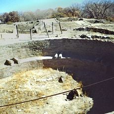
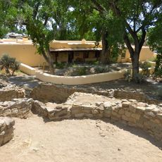
Frances Canyon Ruin, Archaeological site in Rio Arriba County, New Mexico, United States.

Description

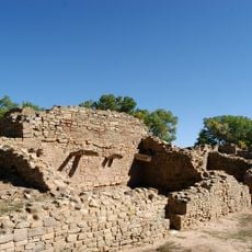
Frances Canyon Ruin is an archaeological site in Rio Arriba County with stone walls and foundations on elevated terrain. The remains show multiple rooms with sturdy wall constructions that spread across the landscape.

History

The site was built around 1716 and served as a pueblito structure during conflicts with Ute and Comanche groups. This fortification arose during a time of great tensions in the region.

Culture

The site shows building elements that blend Pueblo techniques with Navajo traditions that developed after the Pueblo Revolt. Visitors can see how the rooms and walls were shaped for shared life among different peoples.

Practical

The site is reachable via NM Highway 527 north from US 64 to mile marker 11. A short walking trail leads to the remains and provides easy access to the area.

Did you know?

The ruins contain hooded fireplaces and observation openings that show defensive features. These security details reveal the builder innovations of the 18th century.

i
Location
i
GPS coordinates
36.76472,-107.49778
i
Latest update
December 14, 2025 18:11

AroundUs brings together thousands of curated places, local tips, and hidden gems, enriched daily by 60,000 contributors worldwide. Discover all places nearby (New Mexico).

Around this place
Durango and Silverton Narrow Gauge Railroad
United States of America

Durango and Silverton Narrow Gauge Railroad

67.9 km
Aztec Ruins National Monument
United States of America

Aztec Ruins National Monument

45.5 km
Chimney Rock National Monument
United States of America

Chimney Rock National Monument

49.5 km
Navajo Lake
United States of America

Navajo Lake

10.8 km
Salmon Ruins
United States of America

Salmon Ruins

47.8 km
Pagosa hot springs
United States of America

Pagosa hot springs

70.1 km
Navajo State Park
United States of America

Navajo State Park

28.3 km
Strater Hotel
United States of America

Strater Hotel

65.9 km
Angel Peak Scenic Area
United States of America

Angel Peak Scenic Area

40.4 km
United States of America

Apache Nugget Casino

71.8 km
Southern Ute Cultural Center and Museum
United States of America

Southern Ute Cultural Center and Museum

42.9 km
Crow Canyon Archaeological District
United States of America

Crow Canyon Archaeological District

26.5 km
Farmington Public Library
United States of America

Farmington Public Library

60.8 km
Main Avenue Historic District
United States of America

Main Avenue Historic District

66 km
Durango Discovery Museum
United States of America

Durango Discovery Museum

66.6 km
Farmington Historic Downtown Commercial District
United States of America

Farmington Historic Downtown Commercial District

63.3 km
Labo Del Rio Bridge
United States of America

Labo Del Rio Bridge

35.6 km
Aztec Ruins Administration Building-Museum
United States of America

Aztec Ruins Administration Building-Museum

45.5 km
American Hotel
United States of America

American Hotel

45 km
Aztec Main Street Historic District
United States of America

Aztec Main Street Historic District

45.1 km
D.C. Ball House
United States of America

D.C. Ball House

44.2 km
Aztec Motor Company Building
United States of America

Aztec Motor Company Building

44.9 km
Engleman-Thomas Building
United States of America

Engleman-Thomas Building

45.4 km
Church Avenue-Lovers Lane Historic District
United States of America

Church Avenue-Lovers Lane Historic District

44.8 km
Hillcrest Golf Club
United States of America

Hillcrest Golf Club

66.2 km
Lemon Reservoir
United States of America

Lemon Reservoir

72.2 km
Aztec Museum
United States of America

Aztec Museum

44.8 km
Aztec Public Library
United States of America

Aztec Public Library

45.1 km
Show the full map
« Frances Canyon Ruin - Archaeological site in Rio Arriba County, New Mexico, United States » is provided by Around Us (aroundus.com). Images and texts are derived from Wikimedia project under a Creative Commons license. You are allowed to copy, distribute, and modify copies of this page, under the conditions set by the license, as long as this note is clearly visible.

Discover hidden gems everywhere you go!

From secret cafés to breathtaking viewpoints, skip the crowded tourist spots and find places that match your style. Our app makes it easy with voice search, smart filtering, route optimization, and insider tips from travelers worldwide. Download now for the complete mobile experience.

Around Us App Screenshot

A unique approach to discovering new places

Le Figaro

All the places worth exploring

France Info

A tailor-made excursion in just a few clicks

20 Minutes

Around Us
Travel Guide & Maps
Download

Send to your phone

QR Code
1

Open the camera app on your mobile.

2

Point at the QR code with your camera. A notification will appear.

3

Tap the notification to open the link.