Enable Location

We need your location to show you interesting places around you

Discover nearby places

Find interesting locations and hidden gems around you

Precise directions

Get accurate directions and distances to places

Your location is never shared with other users. It's only used when you tap the location button.

Angel Peak Scenic Area

Log in to your account

Start exploring — it's free

Trusted by 61,550 travelers worldwide

Continue with Google
Continue with Apple
or

We will send you a code to connect

By continuing, you accept our Terms and Conditions and our Privacy Policy

Check your inbox

We've sent a pincode in your inbox. Please enter the code below.

Angel Peak Scenic Area

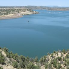
Angel Peak Scenic Area, Protected area in San Juan County, New Mexico.

Description

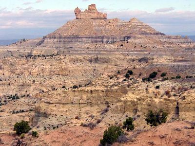
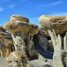
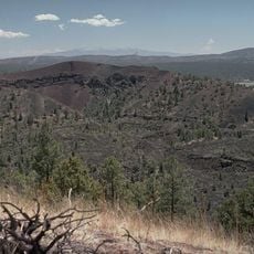
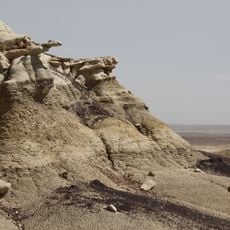
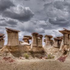
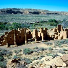
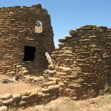
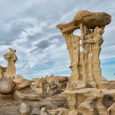
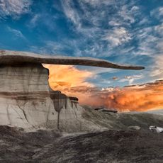
Angel Peak is a protected area in New Mexico that reaches 6,988 feet and features multicolored rock formations across about 10,000 acres of desert landscape. The site displays layers of sandstone, siltstone, and mudstone that reflect different geological time periods.

History

The formations in the area developed millions of years ago when this region was covered by seas. Fossil remains of early mammals in the layers show how life on Earth changed over long periods of time.

Culture

The area holds significance for local tribal communities connected to this land and its natural formations. Visitors can experience the striking colors and shapes of the landscape as they walk through the terrain.

Practical

The area offers three picnic zones with shelters, tables, and restroom facilities, plus nine camping spots along the canyon rim. A walking trail leads to an overlook where visitors can observe the layered colors and canyon formations.

Did you know?

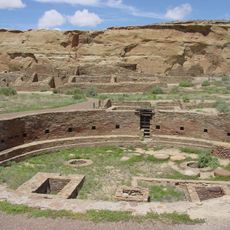
The area contains fossils from the Nacimiento Formation that reveal rare finds of early mammal species from a lesser-studied geological period. These fossils help scientists understand a gap in evolution between major ages of Earth's history.

Location
GPS coordinates
36.54790,-107.86020
Latest update
December 12, 2025 17:43

AroundUs brings together thousands of curated places, local tips, and hidden gems, enriched daily by 60,000 contributors worldwide. Discover all places nearby (New Mexico).

Around this place
Pueblo Bonito
United States of America

Pueblo Bonito

55 km
Bisti/De-Na-Zin Wilderness
United States of America

Bisti/De-Na-Zin Wilderness

35.6 km
Aztec Ruins National Monument
United States of America

Aztec Ruins National Monument

34.5 km
United States of America

Chetro Ketl

54.9 km
Navajo Lake
United States of America

Navajo Lake

37.9 km
Trail of the Ancients Scenic Byway
United States of America

Trail of the Ancients Scenic Byway

55.2 km
Kirtland Formation
United States of America

Kirtland Formation

47.2 km
Ah-shi-sle-pah Wilderness
United States of America

Ah-shi-sle-pah Wilderness

42.7 km
Salmon Ruins
United States of America

Salmon Ruins

22.7 km
Pueblo Alto
United States of America

Pueblo Alto

53.9 km
Pueblo del Arroyo
United States of America

Pueblo del Arroyo

55 km
Crow Canyon Archaeological District
United States of America

Crow Canyon Archaeological District

21.8 km
Kin Kletso
United States of America

Kin Kletso

54.6 km
Farmington Public Library
United States of America

Farmington Public Library

36.3 km
Frances Canyon Ruin
United States of America

Frances Canyon Ruin

40.4 km
Farmington Historic Downtown Commercial District
United States of America

Farmington Historic Downtown Commercial District

36.9 km
Aztec Ruins Administration Building-Museum
United States of America

Aztec Ruins Administration Building-Museum

34.3 km
American Hotel
United States of America

American Hotel

32.6 km
Aztec Main Street Historic District
United States of America

Aztec Main Street Historic District

32.9 km
D.C. Ball House
United States of America

D.C. Ball House

32.8 km
Aztec Motor Company Building
United States of America

Aztec Motor Company Building

32.7 km
Engleman-Thomas Building
United States of America

Engleman-Thomas Building

32.9 km
Church Avenue-Lovers Lane Historic District
United States of America

Church Avenue-Lovers Lane Historic District

32.9 km
Valley of Dreams
United States of America

Valley of Dreams

45.7 km
King of Wings
United States of America

King of Wings

43.1 km
Aztec Museum
United States of America

Aztec Museum

32.9 km
Chaco Culture National Historical Park - Contiguous unit
United States of America

Chaco Culture National Historical Park - Contiguous unit

54.8 km
Aztec Public Library
United States of America

Aztec Public Library

32.7 km
Show the full map
« Angel Peak Scenic Area - Protected area in San Juan County, New Mexico » is provided by Around Us (aroundus.com). Images and texts are derived from Wikimedia project under a Creative Commons license. You are allowed to copy, distribute, and modify copies of this page, under the conditions set by the license, as long as this note is clearly visible.

Discover hidden gems everywhere you go!

From secret cafés to breathtaking viewpoints, skip the crowded tourist spots and find places that match your style. Our app makes it easy with voice search, smart filtering, route optimization, and insider tips from travelers worldwide. Download now for the complete mobile experience.

Around Us App Screenshot

A unique approach to discovering new places

Le Figaro

All the places worth exploring

France Info

A tailor-made excursion in just a few clicks

20 Minutes

Around Us
Travel Guide & Maps
Download

Send to your phone

QR Code
1

Open the camera app on your mobile.

2

Point at the QR code with your camera. A notification will appear.

3

Tap the notification to open the link.