Kirtland Formation

Log in to your account

AroundUs is a community-driven map of interesting places, built by curious explorers like you. It grows with every review, story, and photo you share.
Connect to save your favorite spots, contribute locations, and create personalized routes.
By continuing, you accept our Terms and Conditions and our Privacy Policy

Kirtland Formation

Add to collection
Map
Suggest a change
Share

Kirtland Formation, Geological formation in San Juan Basin, New Mexico, United States.

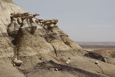
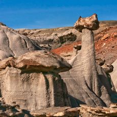
The Kirtland Formation is a geological layered deposit in the San Juan Basin and consists of alternating bands of sandstone, shale, mudstone, and conglomerate. These strata extend upward about 594 meters (1,950 feet) and reveal the complex history of ancient river deltas and coastal environments.

The formation was named in 1916 by C.M. Bauer after the nearby Kirtland Post Office. It dates to the Late Cretaceous period, roughly 75 to 73.5 million years ago.

Scientists have discovered multiple dinosaur species within the formation, including Alamosaurus, Bistahieversor, Daspletosaurus, Pentaceratops, and Kritosaurus specimens.

Visitors can explore the formation in the San Juan Basin region, where several exposures reveal the rock layers. Best access comes during dry seasons when approaching the visible strata is more straightforward.

The Hunter Wash member at the base contains traces of ancient river systems and coastal plains from the Cretaceous. Fossils of large sauropods and horned dinosaurs have been uncovered within these layers.

Location: New Mexico

GPS coordinates: 36.70800,-108.35000

Latest update: December 10, 2025 15:58

Photos
Around this place
Show the full map
Shiprock
United States of America

Shiprock

43.4 km
Bisti/De-Na-Zin Wilderness
United States of America

Bisti/De-Na-Zin Wilderness

49.5 km
Aztec Ruins National Monument
United States of America

Aztec Ruins National Monument

34.4 km
Salmon Ruins
United States of America

Salmon Ruins

28.8 km
Fruitland Formation
United States of America

Fruitland Formation

9.6 km
Angel Peak Scenic Area
United States of America

Angel Peak Scenic Area

47.2 km
Farmington Public Library
United States of America

Farmington Public Library

16 km
Cathedral Cliff
United States of America

Cathedral Cliff

33.8 km
Farmington Historic Downtown Commercial District
United States of America

Farmington Historic Downtown Commercial District

13 km
Balcony House
United States of America

Balcony House

51.5 km
House of Many Windows
United States of America

House of Many Windows

51.4 km
Aztec Ruins Administration Building-Museum
United States of America

Aztec Ruins Administration Building-Museum

34.2 km
San Juan River Bridge at Shiprock
United States of America

San Juan River Bridge at Shiprock

31.6 km
American Hotel
United States of America

American Hotel

33.7 km
Aztec Main Street Historic District
United States of America

Aztec Main Street Historic District

33.8 km
D.C. Ball House
United States of America

D.C. Ball House

34.7 km
Aztec Motor Company Building
United States of America

Aztec Motor Company Building

33.9 km
Engleman-Thomas Building
United States of America

Engleman-Thomas Building

33.5 km
Church Avenue-Lovers Lane Historic District
United States of America

Church Avenue-Lovers Lane Historic District

34.2 km
Oak Tree House
United States of America

Oak Tree House

51.9 km
Sun Temple
United States of America

Sun Temple

52.1 km
Hemenway House
United States of America

Hemenway House

51 km
Sunset House
United States of America

Sunset House

51.8 km
New Fire House
United States of America

New Fire House

52.2 km
Aztec Museum
United States of America

Aztec Museum

34.2 km
Aztec Public Library
United States of America

Aztec Public Library

33.7 km
Cliff Canyon
United States of America

Cliff Canyon

50.3 km
Sun Point View
United States of America

Sun Point View

51.8 km
Show the full map
Reviews

Visited this place? Tap the stars to rate it and share your experience / photos with the community! Try now! You can cancel it anytime.

« Kirtland Formation - Geological formation in San Juan Basin, New Mexico, United States » is provided by Around Us (aroundus.com). Images and texts are derived from Wikimedia project under a Creative Commons license. You are allowed to copy, distribute, and modify copies of this page, under the conditions set by the license, as long as this note is clearly visible.

Discover hidden gems everywhere you go!

From secret cafés to breathtaking viewpoints, skip the crowded tourist spots and find places that match your style. Our app makes it easy with voice search, smart filtering, route optimization, and insider tips from travelers worldwide. Download now for the complete mobile experience.

Around Us App Screenshot

A unique approach to discovering new places

Le Figaro

All the places worth exploring

France Info

A tailor-made excursion in just a few clicks

20 Minutes