Enable Location

We need your location to show you interesting places around you

Discover nearby places

Find interesting locations and hidden gems around you

Precise directions

Get accurate directions and distances to places

Your location is never shared with other users. It's only used when you tap the location button.

Fruitland Formation

Log in to your account

Start exploring — it's free

Trusted by 62,278 travelers worldwide

Continue with Google
Continue with Apple
or

We will send you a code to connect

By continuing, you accept our Terms and Conditions and our Privacy Policy

Check your inbox

We've sent a pincode in your inbox. Please enter the code below.

Fruitland Formation

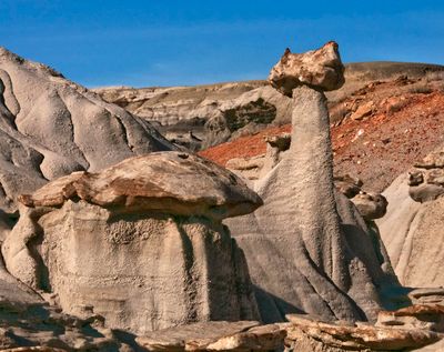
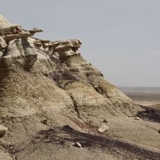
Fruitland Formation, Geological formation in San Juan Basin, United States.

The Fruitland Formation spreads across Colorado and New Mexico with distinct layers of rock stacked one above another. This area within the San Juan Basin holds sandstone, clay, and coal deposits distributed over wide expanses.

These layers formed about 76 million years ago during the Cretaceous time when a vast sea covered part of this continent. The rocks record an ancient period when seawater regularly flowed across the region.

The formation is known for its dinosaur fossils preserved in the sediment layers. Visitors can observe at excavation sites how researchers uncover and study these prehistoric remains.

The area is best explored by staying on marked paths and viewing the geology from accessible locations. Visitors should know this is a large region, so comfortable walking shoes and extra time for hiking are important considerations.

The formation is a source of natural gas seepage that occurs when methane escapes from the coal beds into the air. This is part of a larger pattern in the region that particularly interests researchers and geologists.

The community of curious travelers

AroundUs brings together thousands of curated places, local tips, and hidden gems, enriched daily by 60,000 contributors worldwide.

Start exploring
Location
Location
GPS coordinates
36.75200,-108.44200
Latest update
December 10, 2025 20:03
Around this place
Shiprock
United States of America

Shiprock

35.9 km
Aztec Ruins National Monument
United States of America

Aztec Ruins National Monument

40.5 km
Kirtland Formation
United States of America

Kirtland Formation

9.6 km
Salmon Ruins
United States of America

Salmon Ruins

37.4 km
Farmington Public Library
United States of America

Farmington Public Library

23.5 km
Chimney Rock
United States of America

Chimney Rock

43.9 km
Cathedral Cliff
United States of America

Cathedral Cliff

28.6 km
Farmington Historic Downtown Commercial District
United States of America

Farmington Historic Downtown Commercial District

21.2 km
House of Many Windows
United States of America

House of Many Windows

45.4 km
Balcony House
United States of America

Balcony House

45.6 km
Aztec Ruins Administration Building-Museum
United States of America

Aztec Ruins Administration Building-Museum

40.4 km
San Juan River Bridge at Shiprock
United States of America

San Juan River Bridge at Shiprock

22.5 km
American Hotel
United States of America

American Hotel

40.2 km
Aztec Main Street Historic District
United States of America

Aztec Main Street Historic District

40.3 km
D.C. Ball House
United States of America

D.C. Ball House

41.2 km
Aztec Motor Company Building
United States of America

Aztec Motor Company Building

40.5 km
Engleman-Thomas Building
United States of America

Engleman-Thomas Building

40 km
Church Avenue-Lovers Lane Historic District
United States of America

Church Avenue-Lovers Lane Historic District

40.6 km
Oak Tree House
United States of America

Oak Tree House

45.9 km
Sun Temple
United States of America

Sun Temple

46 km
Hemenway House
United States of America

Hemenway House

45.2 km
Fire Temple
United States of America

Fire Temple

46.1 km
Sunset House
United States of America

Sunset House

45.8 km
New Fire House
United States of America

New Fire House

46.1 km
Aztec Museum
United States of America

Aztec Museum

40.7 km
Aztec Public Library
United States of America

Aztec Public Library

40.2 km
Cliff Canyon
United States of America

Cliff Canyon

44.4 km
Sun Point View
United States of America

Sun Point View

45.8 km
Show the full map
« Fruitland Formation - Geological formation in San Juan Basin, United States » is provided by Around Us (aroundus.com). Images and texts are derived from Wikimedia project under a Creative Commons license. You are allowed to copy, distribute, and modify copies of this page, under the conditions set by the license, as long as this note is clearly visible.

Discover hidden gems everywhere you go!

From secret cafés to breathtaking viewpoints, skip the crowded tourist spots and find places that match your style. Our app makes it easy with voice search, smart filtering, route optimization, and insider tips from travelers worldwide. Download now for the complete mobile experience.

Around Us App Screenshot

A unique approach to discovering new places

Le Figaro

All the places worth exploring

France Info

A tailor-made excursion in just a few clicks

20 Minutes

Around Us
Travel Guide & Maps
Download

Send to your phone

QR Code
1

Open the camera app on your mobile.

2

Point at the QR code with your camera. A notification will appear.

3

Tap the notification to open the link.