Chest opened
+${chestReward.xp} XP
Explorer
NOUVEAU ×${chestReward.collectible.quantity}
tapez pour fermer
Chest locked

Open chests in the app

Around Us is built for your phone — chests unlock when you walk, explore and capture nearby places.

Enable Location

We need your location to show you interesting places around you

Discover nearby places

Find interesting locations and hidden gems around you

Precise directions

Get accurate directions and distances to places

Your location is never shared with other users. It's only used when you tap the location button.

Purgatoire River

Log in to your account

Start exploring — it's free

Trusted by 72,876 travelers worldwide

Continue with Google
Continue with Apple
or

We will send you a code to connect

By continuing, you accept our Terms and Conditions and our Privacy Policy

Check your inbox

We've sent a pincode in your inbox. Please enter the code below.

Purgatoire River
Discussion Reviews 1 Photos
12.4k Popularity

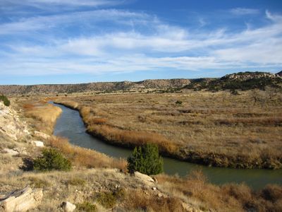
Purgatoire River, River system in southeastern Colorado, United States.

The Purgatoire River flows eastward across southeastern Colorado through three counties, carving deep channels through limestone and sandstone layers. Along its course, the river winds through varied terrain where water seeps from springs and seasonal runoff feeds its flow.

Spanish traders named this waterway Rio de las Ánimas in 1719, a name that echoes in the river's current identity. Over time it became a route through the region as communities developed along its banks.

The river served as a home and gathering place for Jicarilla Apache, Southern Utes, and Comanche peoples for generations. Walking along its banks today offers a connection to the stories and traditions of these communities.

Water flow varies throughout the year, with higher levels during spring snowmelt and after heavy rains in other seasons. The banks can be steep and slippery in places, so sturdy footwear helps when exploring along the edge.

The riverbanks preserve over 1,500 dinosaur footprints from the Jurassic period, making it one of North America's largest collections of such fossils in stone. These tracks offer a glimpse into an ancient time when enormous creatures roamed this now-arid landscape.

The community of curious travelers

AroundUs brings together thousands of curated places, local tips, and hidden gems, enriched daily by 60,000 contributors worldwide.

Start exploring
Location
Location
Elevation above the sea
1,177 m
GPS coordinates
38.06500,-103.17700
Latest update
December 7, 2025 20:45
Around this place
Fort Lyon
United States of America

Fort Lyon

4 km
John Martin Reservoir
United States of America

John Martin Reservoir

19.5 km
John Martin Reservoir State Park
United States of America

John Martin Reservoir State Park

21.6 km
Koshare Indian Museum
United States of America

Koshare Indian Museum

33.9 km
Bent County High School
United States of America

Bent County High School

4.8 km
Bent County Courthouse and Jail
United States of America

Bent County Courthouse and Jail

3.8 km
Prowers Bridge
United States of America

Prowers Bridge

36 km
Dr. Frank Finney House
United States of America

Dr. Frank Finney House

33.8 km
United States of America

Wiley Rock Schoolhouse

41.3 km
Hotel Holly–Haswell Hotel
United States of America

Hotel Holly–Haswell Hotel

43.2 km
Daniel Sciumbato Grocery Store
United States of America

Daniel Sciumbato Grocery Store

34 km
North La Junta School
United States of America

North La Junta School

31.8 km
Wilson A. Hart House
United States of America

Wilson A. Hart House

33.4 km
La Junta Swimming Pool
United States of America

La Junta Swimming Pool

34.6 km
United States of America

Otero Museum Association

34 km
United States of America

John W. Rawlings Heritage Center & Museum

3.8 km
United States of America

Holbrook Reservoir

38 km
United States of America

Horse Creek Reservoir

23.2 km
United States of America

Adobe Creek Reservoir

22.7 km
United States of America

Bust of Christopher Columbus

27.9 km
United States of America

Todd Point

38.2 km
United States of America

East Canyon

44.5 km
United States of America

Dixie Bluffs

39.9 km
United States of America

Mesa Theatre

32.9 km
United States of America

Koshare Museum & Trading Post

33.9 km
United States of America

La Junta Golf Club

29.8 km
United States of America

Southwest Chief train mural

33.4 km
United States of America

Waterfall

42.7 km
Show the full map
Reviews
Share your experience

No review yet

Discussions
Start a discussion...

No discussion yet

« Purgatoire River - River system in southeastern Colorado, United States » is provided by Around Us (aroundus.com). Images and texts are derived from Wikimedia project under a Creative Commons license. You are allowed to copy, distribute, and modify copies of this page, under the conditions set by the license, as long as this note is clearly visible.

Discover hidden gems everywhere you go!

From secret cafés to breathtaking viewpoints, skip the crowded tourist spots and find places that match your style. Our app makes it easy with voice search, smart filtering, route optimization, and insider tips from travelers worldwide. Download now for the complete mobile experience.

Around Us App Screenshot

A unique approach to discovering new places

Le Figaro

All the places worth exploring

France Info

A tailor-made excursion in just a few clicks

20 Minutes

Around Us
Travel Guide & Maps
Download

Send to your phone

QR Code
1

Open the camera app on your mobile.

2

Point at the QR code with your camera. A notification will appear.

3

Tap the notification to open the link.