Chest opened
+${chestReward.xp} XP
Explorer
NOUVEAU ×${chestReward.collectible.quantity}
tapez pour fermer
Chest locked

Open chests in the app

Around Us is built for your phone — chests unlock when you walk, explore and capture nearby places.

Enable Location

We need your location to show you interesting places around you

Discover nearby places

Find interesting locations and hidden gems around you

Precise directions

Get accurate directions and distances to places

Your location is never shared with other users. It's only used when you tap the location button.

Fort Carson

Log in to your account

Start exploring — it's free

Trusted by 72,990 travelers worldwide

Continue with Google
Continue with Apple
or

We will send you a code to connect

By continuing, you accept our Terms and Conditions and our Privacy Policy

Check your inbox

We've sent a pincode in your inbox. Please enter the code below.

Discussion Reviews 2 Photos
111k Popularity

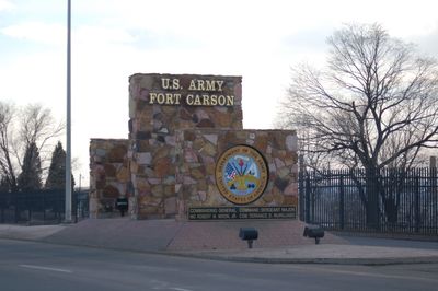
Fort Carson, Military base in El Paso County, Colorado.

Fort Carson is a military base in El Paso County, Colorado, that spreads across training grounds, residential neighborhoods, and administrative buildings. The installation sits at an elevation of 1,772 meters (5,814 feet) and features manicured lawns, wide streets, and rows of two-story houses in earth tones.

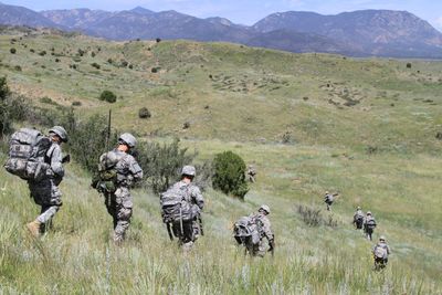
The base opened in January 1942, shortly after the Pearl Harbor attack, to train troops for World War II. Several conflicts since that time expanded the facilities and changed the role of the site in the country's military system.

The name honors a 19th-century frontier officer and scout who served across the western territories. Military families and civilian employees live here in a self-contained community with its own schools and social facilities.

Entry happens through controlled gates where visitors must present valid identification and possibly prior authorization. The grounds are wide, so having a car helps when moving between different areas.

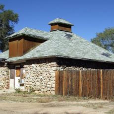
During World War II, the base held around 9,000 Italian and German prisoners of war who worked on local farms and logging camps. Some of the old camp barracks still stand today, reminding visitors of that time.

The community of curious travelers

AroundUs brings together thousands of curated places, local tips, and hidden gems, enriched daily by 60,000 contributors worldwide.

Start exploring
Location
Inception
January 31, 1942
Elevation above the sea
1,772 m
GPS coordinates
38.55556,-104.84256
Latest update
December 12, 2025 22:44
Around this place
Pikes Peak International Raceway
United States of America

Pikes Peak International Raceway

15 km
Cheyenne Mountain State Park
United States of America

Cheyenne Mountain State Park

19.9 km
Liscum Bowl
United States of America

Liscum Bowl

5 m
St. Peter's Dome
United States of America

St. Peter's Dome

22.2 km
Mount Rosa
United States of America

Mount Rosa

23.9 km
United States of America

Brush Hollow Reservoir

21 km
May Natural History Museum
United States of America

May Natural History Museum

16.7 km
United States of America

Beaver Creek State Wildlife Area

15.9 km
Old Livery Stable
United States of America

Old Livery Stable

18.7 km
United States of America

Brush Hollow State Wildlife Area

20.8 km
United States of America

Fountain Valley Historical Society And Museum

18.9 km
Adelaide Bridge No 10
United States of America

Adelaide Bridge No 10

21.3 km
United States of America

Devils Slide

21.3 km
Portland Bridge
United States of America

Portland Bridge

23.9 km
United States of America

Cheyenne Shadows Golf Course

18.7 km
United States of America

Broadmoor Cheyenne

23.9 km
United States of America

Tiger

24 km
United States of America

Domestic Goats

23.9 km
United States of America

Amphitheater

20.2 km
United States of America

Prairie Falcon Amphitheatre

20.2 km
United States of America

ALLAN HERSCHELL CAROUSEL

23.9 km
United States of America

Children Holding Hands

23.3 km
United States of America

Statue, Work of art

24 km
United States of America

Statue, Work of art

24 km
United States of America

Statue, Work of art

23.9 km
United States of America

Scenic viewpoint

21.3 km
United States of America

Scenic viewpoint

24 km
United States of America

Scenic viewpoint

22.9 km
Show the full map
Reviews
Share your experience

No review yet

Discussions
Start a discussion...

No discussion yet

« Fort Carson - Military base in El Paso County, Colorado » is provided by Around Us (aroundus.com). Images and texts are derived from Wikimedia project under a Creative Commons license. You are allowed to copy, distribute, and modify copies of this page, under the conditions set by the license, as long as this note is clearly visible.

Discover hidden gems everywhere you go!

From secret cafés to breathtaking viewpoints, skip the crowded tourist spots and find places that match your style. Our app makes it easy with voice search, smart filtering, route optimization, and insider tips from travelers worldwide. Download now for the complete mobile experience.

Around Us App Screenshot

A unique approach to discovering new places

Le Figaro

All the places worth exploring

France Info

A tailor-made excursion in just a few clicks

20 Minutes

Around Us
Travel Guide & Maps
Download

Send to your phone

QR Code
1

Open the camera app on your mobile.

2

Point at the QR code with your camera. A notification will appear.

3

Tap the notification to open the link.