Enable Location

We need your location to show you interesting places around you

Discover nearby places

Find interesting locations and hidden gems around you

Precise directions

Get accurate directions and distances to places

Your location is never shared with other users. It's only used when you tap the location button.

Soldier Creek Dam

Log in to your account

Start exploring — it's free

Trusted by 62,836 travelers worldwide

Continue with Google
Continue with Apple
or

We will send you a code to connect

By continuing, you accept our Terms and Conditions and our Privacy Policy

Check your inbox

We've sent a pincode in your inbox. Please enter the code below.

Soldier Creek Dam

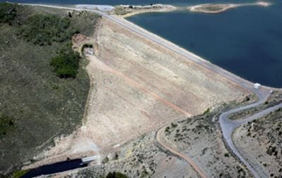
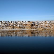
Soldier Creek Dam, Embankment dam in Wasatch County, United States.

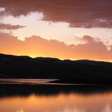
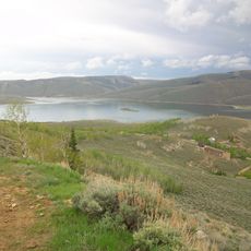
Soldier Creek Dam is an earth-and-rock embankment dam built across the Strawberry River in the Uinta National Forest. The structure rises prominently from the valley floor and creates a large reservoir used for irrigation and power generation throughout the region.

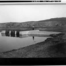
The Bureau of Reclamation completed this dam in 1974, replacing an earlier structure dating to 1913. This replacement greatly increased water storage capacity for the entire Utah Valley region.

The dam is part of a regional water management system that has supported farming across Utah for generations. Visitors can observe how this structure shapes the landscape and its role in local water distribution.

The area around the dam is best explored on foot from accessible viewpoints, which offer views of the reservoir and surrounding landscape. Visitors should expect changing weather conditions at this elevation and dress accordingly.

The dam was built using a special blend of earth and rock materials that was innovative for its time. This construction method allowed engineers to create an especially tall structure that remains dependable today.

The community of curious travelers

AroundUs brings together thousands of curated places, local tips, and hidden gems, enriched daily by 60,000 contributors worldwide.

Start exploring
Location
Inception
1974
GPS coordinates
40.13670,-111.02700
Latest update
December 13, 2025 17:06
Around this place
Strawberry Reservoir
United States of America

Strawberry Reservoir

9.5 km
Springville High School
United States of America

Springville High School

47.8 km
Scofield Reservoir
United States of America

Scofield Reservoir

39.7 km
Springville Museum of Art
United States of America

Springville Museum of Art

49.5 km
Provo Peak
United States of America

Provo Peak

46.6 km
Springville Carnegie Library
United States of America

Springville Carnegie Library

49.7 km
Dallin House
United States of America

Dallin House

49.1 km
John Hafen House
United States of America

John Hafen House

49.6 km
Mont and Harriet Johnson House
United States of America

Mont and Harriet Johnson House

49.5 km
Stockmore Ranger Station
United States of America

Stockmore Ranger Station

40.3 km
Roswell Darius Bird Sr. House
United States of America

Roswell Darius Bird Sr. House

46.9 km
Crandall Houses
United States of America

Crandall Houses

49.5 km
Springville High School Mechanical Arts Building
United States of America

Springville High School Mechanical Arts Building

49.3 km
Roe A. and Louise R. Deal House
United States of America

Roe A. and Louise R. Deal House

49.6 km
Springville Presbyterian Church
United States of America

Springville Presbyterian Church

49.4 km
Deal-Mendenhall Hall
United States of America

Deal-Mendenhall Hall

49.5 km
Ami and Amanda Oakley House
United States of America

Ami and Amanda Oakley House

49.4 km
James P. and Lydia Strang House
United States of America

James P. and Lydia Strang House

49.3 km
Patrick L. and Rose O. Ward House
United States of America

Patrick L. and Rose O. Ward House

49.6 km
Starvation Reservoir
United States of America

Starvation Reservoir

48.1 km
East Portal
United States of America

East Portal

14 km
Emma Park
United States of America

Emma Park

40.5 km
Dripping Rock Trail
United States of America

Dripping Rock Trail

49.1 km
Spanish Fork Canyon
United States of America

Spanish Fork Canyon

48.8 km
Scofield State Park
United States of America

Scofield State Park

42.4 km
Soldier Summit Cemetery
United States of America

Soldier Summit Cemetery

24.2 km
Spanish Fork River Trail
United States of America

Spanish Fork River Trail

48.8 km
Price Canyon
United States of America

Price Canyon

49.5 km
Show the full map
« Soldier Creek Dam - Embankment dam in Wasatch County, United States » is provided by Around Us (aroundus.com). Images and texts are derived from Wikimedia project under a Creative Commons license. You are allowed to copy, distribute, and modify copies of this page, under the conditions set by the license, as long as this note is clearly visible.

Discover hidden gems everywhere you go!

From secret cafés to breathtaking viewpoints, skip the crowded tourist spots and find places that match your style. Our app makes it easy with voice search, smart filtering, route optimization, and insider tips from travelers worldwide. Download now for the complete mobile experience.

Around Us App Screenshot

A unique approach to discovering new places

Le Figaro

All the places worth exploring

France Info

A tailor-made excursion in just a few clicks

20 Minutes

Around Us
Travel Guide & Maps
Download

Send to your phone

QR Code
1

Open the camera app on your mobile.

2

Point at the QR code with your camera. A notification will appear.

3

Tap the notification to open the link.