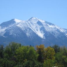
Dotsero, Volcanic crater in Eagle County, Colorado, United States.
Dotsero is an elongate maar, about 700 m long and 400 m wide, cut into the sedimentary strata of Blowout Hill northeast of Dotsero, Colorado, near the junction of the Colorado and Eagle rivers. Its north rim stands roughly 100 m above the south rim, and the crater is about 400 m deep. Small scoria cones line a NNE-SSW axis on either side of the maar, and a basaltic lava flow up to 11 m thick covers part of the Eagle River floodplain.
Dotsero Crater was first described in 1888 by P. H. Van Diest, followed by R. E. Lakes in 1890, who proposed an eruption within the human period. Radiocarbon dating of wood beneath the lava flows later placed the single eruption at about 2220 BC ± 300, making it one of the youngest eruptions in the continental United States.
The crater sits on Blowout Hill beside a mobile home park at the foot of the volcano, and Interstate 70 was cut across the lava flow that reaches the Eagle River floodplain. The name Dotsero comes from the local railroad stop; the crater itself is a landmark for travellers on the highway.
The crater sits northeast of Dotsero near the junction of the Colorado and Eagle rivers, and Interstate 70 cuts across the lava flow at the volcano's base. The crater is incised into the side of Blowout Hill, with a north rim about 100 m higher than the south rim. A mobile home park stands at the base of the volcano.
The volcanic deposits contain fragments of oxidized sandstone from older rock layers beneath the surface. This mixture shows how the eruption brought material from different depths to the surface.
The community of curious travelers
AroundUs brings together thousands of curated places, local tips, and hidden gems, enriched daily by 94,523 contributors worldwide.