Enable Location

We need your location to show you interesting places around you

Discover nearby places

Find interesting locations and hidden gems around you

Precise directions

Get accurate directions and distances to places

Your location is never shared with other users. It's only used when you tap the location button.

Calhan Paint Mines Archeological District

Log in to your account

Start exploring — it's free

Trusted by 62,193 travelers worldwide

Continue with Google
Continue with Apple
or

We will send you a code to connect

By continuing, you accept our Terms and Conditions and our Privacy Policy

Check your inbox

We've sent a pincode in your inbox. Please enter the code below.

Calhan Paint Mines Archeological District, Archaeological park in El Paso County, Colorado, US

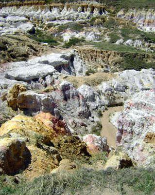
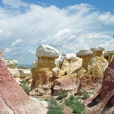
Calhan Paint Mines is a 750-acre protected area in Colorado featuring bands of colored clay, towering sandstone formations, and natural rock spires carved by erosion. Visitors can explore these geological structures on marked trails with interpretive signs throughout the landscape.

Archaeological remains show continuous human occupation here for 9,000 years, with artifacts from the Apishapa, Cody, and Duncan cultures uncovered across the site. This long timeline demonstrates how different peoples relied on the area's mineral resources over many centuries.

Ancestral Puebloans mined clay and minerals from this site to craft pottery and create pigments for ceremonial work. The practice shaped how indigenous groups connected to this landscape through generations of artistic tradition.

The site has four miles of walking paths with interpretive markers, climbing up to 500 feet in elevation. Bring plenty of water since there are no facilities or water sources available on the grounds.

The clay layers display natural color bands created by oxidized iron compounds and jasper deposits, giving the formations their distinctive appearance. This geological feature is likely why ancient peoples specifically chose this location for mining their materials.

The community of curious travelers

AroundUs brings together thousands of curated places, local tips, and hidden gems, enriched daily by 60,000 contributors worldwide.

Start exploring
Location
GPS coordinates
39.02190,-104.26700
Latest update
December 8, 2025 19:54
Around this place
Falcon Stadium
United States of America

Falcon Stadium

49.8 km
Colorado Piedmont
United States of America

Colorado Piedmont

51 km
Chidlaw Building
United States of America

Chidlaw Building

49.7 km
United States Air Force Academy Cemetery
United States of America

United States Air Force Academy Cemetery

50.9 km
Peterson Air and Space Museum
United States of America

Peterson Air and Space Museum

43.7 km
Old North End Historic District
United States of America

Old North End Historic District

51.5 km
Missile Defense Integration and Operations Center
United States of America

Missile Defense Integration and Operations Center

33.3 km
Western Museum of Mining & Industry
United States of America

Western Museum of Mining & Industry

48.6 km
Pikes Peak National Cemetery
United States of America

Pikes Peak National Cemetery

41.7 km
Federal Building
United States of America

Federal Building

50.1 km
National Museum of World War II Aviation
United States of America

National Museum of World War II Aviation

45.2 km
Black Squirrel Creek Bridge
United States of America

Black Squirrel Creek Bridge

21.4 km
Black Forest School
United States of America

Black Forest School

37.6 km
Taylor Memorial Chapel
United States of America

Taylor Memorial Chapel

39.1 km
Drennan School
United States of America

Drennan School

33.9 km
St. Mark United Presbyterian Church
United States of America

St. Mark United Presbyterian Church

32.1 km
J.G. Evans Barn
United States of America

J.G. Evans Barn

37.1 km
S. A. Wilson Elementary School
United States of America

S. A. Wilson Elementary School

49.9 km
First Presbyterian Church of Ramah
United States of America

First Presbyterian Church of Ramah

13.9 km
Cottonwood Creek Bridge
United States of America

Cottonwood Creek Bridge

48.1 km
Spring Valley School
United States of America

Spring Valley School

45.8 km
The Country Club at Woodmoor
United States of America

The Country Club at Woodmoor

50.1 km
El Paso County Fairgrounds
United States of America

El Paso County Fairgrounds

2.6 km
Dr. Lester L. Williams Fire Museum
United States of America

Dr. Lester L. Williams Fire Museum

49.9 km
Paint Mines Interpretive Park
United States of America

Paint Mines Interpretive Park

393 m
Pikes Peak Children's Museum
United States of America

Pikes Peak Children's Museum

49.7 km
Banning Lewis Ranch Vista Water Park
United States of America

Banning Lewis Ranch Vista Water Park

35.7 km
Regal Interquest Stadium 14
United States of America

Regal Interquest Stadium 14

47 km
Show the full map
« Calhan Paint Mines Archeological District - Archaeological park in El Paso County, Colorado, US » is provided by Around Us (aroundus.com). Images and texts are derived from Wikimedia project under a Creative Commons license. You are allowed to copy, distribute, and modify copies of this page, under the conditions set by the license, as long as this note is clearly visible.

Discover hidden gems everywhere you go!

From secret cafés to breathtaking viewpoints, skip the crowded tourist spots and find places that match your style. Our app makes it easy with voice search, smart filtering, route optimization, and insider tips from travelers worldwide. Download now for the complete mobile experience.

Around Us App Screenshot

A unique approach to discovering new places

Le Figaro

All the places worth exploring

France Info

A tailor-made excursion in just a few clicks

20 Minutes

Around Us
Travel Guide & Maps
Download

Send to your phone

QR Code
1

Open the camera app on your mobile.

2

Point at the QR code with your camera. A notification will appear.

3

Tap the notification to open the link.