Chest opened
+${chestReward.xp} XP
Explorer
NOUVEAU ×${chestReward.collectible.quantity}
tapez pour fermer
Chest locked

Open chests in the app

Around Us is built for your phone — chests unlock when you walk, explore and capture nearby places.

Enable Location

We need your location to show you interesting places around you

Discover nearby places

Find interesting locations and hidden gems around you

Precise directions

Get accurate directions and distances to places

Your location is never shared with other users. It's only used when you tap the location button.

Log in to your account

Start exploring — it's free

Trusted by 72,985 travelers worldwide

Continue with Google
Continue with Apple
or

We will send you a code to connect

By continuing, you accept our Terms and Conditions and our Privacy Policy

Check your inbox

We've sent a pincode in your inbox. Please enter the code below.

Pikes Peak Greenway
Discussion Reviews Photo
2k Popularity

Pikes Peak Greenway, Multi-use recreational trail in Colorado Springs, United States.

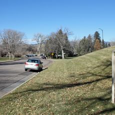
The Pikes Peak Greenway is a multi-surface trail that stretches 15 miles along Monument and Fountain Creeks through Colorado Springs. The path connects different parks and outdoor spaces throughout the city while offering views of the surrounding mountains.

Development of this path began in the 1980s as a vision to connect waterside spaces across the city. A major turning point came in 1997 when significant funding arrived, giving the project regional importance.

The path brings together walkers, runners, and cyclists from across the city and hosts regular community gatherings throughout the year. It connects several sports facilities and youth centers that serve as important gathering spots for local recreation.

Several entry points and parking areas are spread along the entire trail, with the Edmundson Trailhead being the most commonly used starting point on the north side. Visitors will find waymarking throughout and different surfaces as they move between sections.

The trail features a mix of asphalt, concrete, crushed stone, and dirt paths that creates variety as you move through different sections. These different surfaces allow various users to choose the segment that works best for their particular activity.

The community of curious travelers

AroundUs brings together thousands of curated places, local tips, and hidden gems, enriched daily by 60,000 contributors worldwide.

Start exploring
Location
GPS coordinates
38.85960,-104.83200
Latest update
December 14, 2025 11:05
Around this place
Colorado Springs Fine Arts Center
United States of America

Colorado Springs Fine Arts Center

1.6 km
Monument Valley Park
United States of America

Monument Valley Park

744 m
D&RGW 168
United States of America

D&RGW 168

2.8 km
Old North End Historic District
United States of America

Old North End Historic District

856 m
Colorado Springs City Hall
United States of America

Colorado Springs City Hall

2.8 km
St. Mary's Cathedral
United States of America

St. Mary's Cathedral

2.6 km
Grace and St. Stephen's Episcopal Church
United States of America

Grace and St. Stephen's Episcopal Church

2 km
McAllister House
United States of America

McAllister House

2.4 km
Edgeplain
United States of America

Edgeplain

1.5 km
Cutler Hall
United States of America

Cutler Hall

1.4 km
DeGraff Building
United States of America

DeGraff Building

2.7 km
Judson Moss Bemis House
United States of America

Judson Moss Bemis House

2.1 km
Lennox House
United States of America

Lennox House

1.7 km
Bemis Hall
United States of America

Bemis Hall

1.4 km
Fort Collins Municipal Railway No. 22
United States of America

Fort Collins Municipal Railway No. 22

817 m
Colorado Springs Public Library-Carnegie Building
United States of America

Colorado Springs Public Library-Carnegie Building

2.7 km
Emmanuel Presbyterian Church
United States of America

Emmanuel Presbyterian Church

1.5 km
Hagerman Mansion
United States of America

Hagerman Mansion

1.9 km
Palmer Hall
United States of America

Palmer Hall

1.5 km
YWCA Building
United States of America

YWCA Building

2.8 km
Montgomery Hall, Colorado College
United States of America

Montgomery Hall, Colorado College

1.3 km
Giddings Building
United States of America

Giddings Building

2.7 km
Shove Memorial Chapel
United States of America

Shove Memorial Chapel

1.6 km
Burgess House
United States of America

Burgess House

1.9 km
Frederick H. Cossitt Memorial Hall
United States of America

Frederick H. Cossitt Memorial Hall

1.4 km
Ida M. Rice House
United States of America

Ida M. Rice House

1.2 km
Lindley-Johnson-Vanderhoof House
United States of America

Lindley-Johnson-Vanderhoof House

1.2 km
Gwynne–Love House
United States of America

Gwynne–Love House

1.7 km
Show the full map
Reviews
Share your experience

No review yet

Discussions
Start a discussion...

No discussion yet

« Pikes Peak Greenway - Multi-use recreational trail in Colorado Springs, United States » is provided by Around Us (aroundus.com). Images and texts are derived from Wikimedia project under a Creative Commons license. You are allowed to copy, distribute, and modify copies of this page, under the conditions set by the license, as long as this note is clearly visible.

Discover hidden gems everywhere you go!

From secret cafés to breathtaking viewpoints, skip the crowded tourist spots and find places that match your style. Our app makes it easy with voice search, smart filtering, route optimization, and insider tips from travelers worldwide. Download now for the complete mobile experience.

Around Us App Screenshot

A unique approach to discovering new places

Le Figaro

All the places worth exploring

France Info

A tailor-made excursion in just a few clicks

20 Minutes

Around Us
Travel Guide & Maps
Download

Send to your phone

QR Code
1

Open the camera app on your mobile.

2

Point at the QR code with your camera. A notification will appear.

3

Tap the notification to open the link.