Enable Location

We need your location to show you interesting places around you

Discover nearby places

Find interesting locations and hidden gems around you

Precise directions

Get accurate directions and distances to places

Your location is never shared with other users. It's only used when you tap the location button.

Lindenmeier Site

Log in to your account

Start exploring — it's free

Trusted by 62,221 travelers worldwide

Continue with Google
Continue with Apple
or

We will send you a code to connect

By continuing, you accept our Terms and Conditions and our Privacy Policy

Check your inbox

We've sent a pincode in your inbox. Please enter the code below.

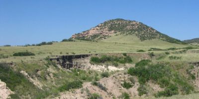
Lindenmeier Site, Archaeological site in Larimer County, US.

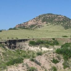
Lindenmeier Site is an archaeological site in Larimer County, Colorado, containing stone tools and animal bones arranged in distinct layers across the landscape. These layers reveal that people lived in and passed through this location repeatedly over thousands of years.

Excavations conducted between 1934 and 1940 by Frank Roberts from the Smithsonian Institution revealed human occupation dating back roughly 11,000 years. This research established the site as a key location for understanding early North American populations.

The site takes its name from the Lindenmeier family, who owned the land where excavations took place. The artifacts reveal how early inhabitants crafted their tools and hunted the animals around them.

The site now forms part of Soapstone Prairie Natural Area, managed by Fort Collins and open to visitors year-round. Walking trails cross the landscape and help guide exploration while protecting active research areas.

Archaeologists discovered a bison vertebra with a spear point lodged inside it, providing direct evidence of how early hunters used their weapons. This find is one of the rare physical confirmations of hunting practices from that ancient period.

The community of curious travelers

AroundUs brings together thousands of curated places, local tips, and hidden gems, enriched daily by 60,000 contributors worldwide.

Start exploring
Location
GPS coordinates
40.97990,-105.06200
Latest update
December 8, 2025 20:00
Around this place
Wyoming State Capitol
United States of America

Wyoming State Capitol

27.1 km
Curt Gowdy State Park
United States of America

Curt Gowdy State Park

25.6 km
400th Missile Squadron
United States of America

400th Missile Squadron

23.6 km
320th Missile Squadron
United States of America

320th Missile Squadron

23.6 km
321st Missile Squadron
United States of America

321st Missile Squadron

23.6 km
Fort D.A. Russell
United States of America

Fort D.A. Russell

26.6 km
Nagle Warren Mansion
United States of America

Nagle Warren Mansion

27.2 km
Soapstone Prairie Natural Area
United States of America

Soapstone Prairie Natural Area

0 m
Downtown Cheyenne Historic District
United States of America

Downtown Cheyenne Historic District

26.7 km
Southeast Wyoming Welcome Center
United States of America

Southeast Wyoming Welcome Center

17.6 km
Cheyenne Depot Museum
United States of America

Cheyenne Depot Museum

26.8 km
Wyoming State Museum
United States of America

Wyoming State Museum

27.1 km
Atlas Theatre
United States of America

Atlas Theatre

26.8 km
Park Addition School
United States of America

Park Addition School

26.4 km
Saint Marks
United States of America

Saint Marks

27 km
Churchill Public School
United States of America

Churchill Public School

26.8 km
Lulu McCormick Junior High School
United States of America

Lulu McCormick Junior High School

27 km
City and County Building
United States of America

City and County Building

26.8 km
Masonic Temple
United States of America

Masonic Temple

26.9 km
McCord-Brady Company
United States of America

McCord-Brady Company

26.5 km
Charles L. Beatty House
United States of America

Charles L. Beatty House

27 km
Cheyenne Depot Plaza
United States of America

Cheyenne Depot Plaza

26.8 km
Federal Office Building
United States of America

Federal Office Building

26.9 km
Wyoming Fuel Company
United States of America

Wyoming Fuel Company

26.3 km
Laramie County Library
United States of America

Laramie County Library

26.7 km
Nelson Museum of the West
United States of America

Nelson Museum of the West

26.7 km
Warren ICBM & Heritage Museum
United States of America

Warren ICBM & Heritage Museum

25.7 km
Lincoln $ Saver
United States of America

Lincoln $ Saver

27 km
Show the full map
« Lindenmeier Site - Archaeological site in Larimer County, US » is provided by Around Us (aroundus.com). Images and texts are derived from Wikimedia project under a Creative Commons license. You are allowed to copy, distribute, and modify copies of this page, under the conditions set by the license, as long as this note is clearly visible.

Discover hidden gems everywhere you go!

From secret cafés to breathtaking viewpoints, skip the crowded tourist spots and find places that match your style. Our app makes it easy with voice search, smart filtering, route optimization, and insider tips from travelers worldwide. Download now for the complete mobile experience.

Around Us App Screenshot

A unique approach to discovering new places

Le Figaro

All the places worth exploring

France Info

A tailor-made excursion in just a few clicks

20 Minutes

Around Us
Travel Guide & Maps
Download

Send to your phone

QR Code
1

Open the camera app on your mobile.

2

Point at the QR code with your camera. A notification will appear.

3

Tap the notification to open the link.