Enable Location

We need your location to show you interesting places around you

Discover nearby places

Find interesting locations and hidden gems around you

Precise directions

Get accurate directions and distances to places

Your location is never shared with other users. It's only used when you tap the location button.

Soapstone Prairie Natural Area

Log in to your account

Start exploring — it's free

Trusted by 63,492 travelers worldwide

Continue with Google
Continue with Apple
or

We will send you a code to connect

By continuing, you accept our Terms and Conditions and our Privacy Policy

Check your inbox

We've sent a pincode in your inbox. Please enter the code below.

Soapstone Prairie Natural Area
Discussion Reviews 1 Photos
3.1k Popularity

Soapstone Prairie Natural Area, Protected grassland area north of Fort Collins, United States

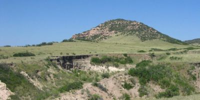
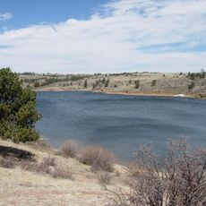
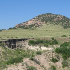
Soapstone Prairie Natural Area is a protected grassland in northern Colorado featuring open prairie and rolling foothills along the Wyoming border. The site offers an expanse of native vegetation crossed by multiple trails that reveal the land's natural character.

The Lindenmeier archaeological site within the area reveals human presence from more than 12,000 years ago through tools from the Folsom culture. These discoveries show a long history of people living and working across this prairie landscape.

Ute tribes moved through this land for generations and left behind stone circles and ceremonial sites that remain visible today. Walking across the prairie, visitors can sense the deep connection between indigenous peoples and this landscape.

The area is open for hiking, horseback riding, and cycling from spring through fall, with trails accessible from designated parking areas. Visitors should prepare for open prairie conditions where weather changes quickly and shade is limited throughout the landscape.

The area shelters a genetically pure bison herd that can be seen from observation points along the Cheyenne Rim Trail. These massive grazing animals remain a rare sight in today's landscape and draw visitors from across the region.

The community of curious travelers

AroundUs brings together thousands of curated places, local tips, and hidden gems, enriched daily by 60,000 contributors worldwide.

Start exploring
Location
Inception
2004
GPS coordinates
40.97990,-105.06200
Latest update
December 12, 2025 09:07
Around this place
Wyoming State Capitol
United States of America

Wyoming State Capitol

27.1 km
Curt Gowdy State Park
United States of America

Curt Gowdy State Park

25.6 km
Lindenmeier Site
United States of America

Lindenmeier Site

0 m
400th Missile Squadron
United States of America

400th Missile Squadron

23.6 km
320th Missile Squadron
United States of America

320th Missile Squadron

23.6 km
321st Missile Squadron
United States of America

321st Missile Squadron

23.6 km
Fort D.A. Russell
United States of America

Fort D.A. Russell

26.6 km
Nagle Warren Mansion
United States of America

Nagle Warren Mansion

27.2 km
Downtown Cheyenne Historic District
United States of America

Downtown Cheyenne Historic District

26.7 km
St. Mary's Catholic Cathedral
United States of America

St. Mary's Catholic Cathedral

27 km
Cheyenne Depot Museum
United States of America

Cheyenne Depot Museum

26.8 km
Wyoming State Museum
United States of America

Wyoming State Museum

27.1 km
Atlas Theatre
United States of America

Atlas Theatre

26.8 km
Park Addition School
United States of America

Park Addition School

26.4 km
Saint Marks
United States of America

Saint Marks

27 km
Churchill Public School
United States of America

Churchill Public School

26.8 km
City and County Building
United States of America

City and County Building

26.8 km
Masonic Temple
United States of America

Masonic Temple

26.9 km
Deming School
United States of America

Deming School

27.2 km
Cheyenne South Side Historic District
United States of America

Cheyenne South Side Historic District

27.2 km
McCord-Brady Company
United States of America

McCord-Brady Company

26.5 km
Charles L. Beatty House
United States of America

Charles L. Beatty House

27 km
Whipple-Lacey House
United States of America

Whipple-Lacey House

27.2 km
Federal Office Building
United States of America

Federal Office Building

26.9 km
Wyoming Fuel Company
United States of America

Wyoming Fuel Company

26.3 km
Ferdinand Lafrentz House
United States of America

Ferdinand Lafrentz House

27.2 km
Lincoln $ Saver
United States of America

Lincoln $ Saver

27 km
Historic Governor's Mansion
United States of America

Historic Governor's Mansion

27.1 km
Show the full map
Reviews
Share your experience

No review yet

Discussions
Start a discussion...

No discussion yet

« Soapstone Prairie Natural Area - Protected grassland area north of Fort Collins, United States » is provided by Around Us (aroundus.com). Images and texts are derived from Wikimedia project under a Creative Commons license. You are allowed to copy, distribute, and modify copies of this page, under the conditions set by the license, as long as this note is clearly visible.

Discover hidden gems everywhere you go!

From secret cafés to breathtaking viewpoints, skip the crowded tourist spots and find places that match your style. Our app makes it easy with voice search, smart filtering, route optimization, and insider tips from travelers worldwide. Download now for the complete mobile experience.

Around Us App Screenshot

A unique approach to discovering new places

Le Figaro

All the places worth exploring

France Info

A tailor-made excursion in just a few clicks

20 Minutes

Around Us
Travel Guide & Maps
Download

Send to your phone

QR Code
1

Open the camera app on your mobile.

2

Point at the QR code with your camera. A notification will appear.

3

Tap the notification to open the link.