Enable Location

We need your location to show you interesting places around you

Discover nearby places

Find interesting locations and hidden gems around you

Precise directions

Get accurate directions and distances to places

Your location is never shared with other users. It's only used when you tap the location button.

Boise River and Canal Bridge

Log in to your account

Start exploring — it's free

Trusted by 62,331 travelers worldwide

Continue with Google
Continue with Apple
or

We will send you a code to connect

By continuing, you accept our Terms and Conditions and our Privacy Policy

Check your inbox

We've sent a pincode in your inbox. Please enter the code below.

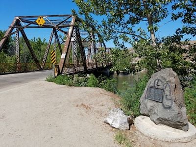
Boise River and Canal Bridge, bridge in United States of America

The Boise River and Canal Bridge is a historic bridge in Caldwell, Idaho that crosses the Boise River. It has three sections supporting one lane of traffic, a roadway width of about 19.5 feet (6 meters), and a clearance height of roughly 14 feet (4 meters), making it unsuitable for large vehicles.

The bridge was built in 1922 by the American Bridge Company and designed by city engineer Fred H. McConnel. It stands on a site where Oregon Trail travelers once forded the Boise River, and it was added to the National Register of Historic Places in 2007.

The bridge carries names that reflect its history: Canyon Hill Bridge, Idaho Pacific Highway Bridge, and Silver Bridge. These names show which roads and places it has connected over time.

Access is straightforward, but note that the roadway is very narrow and only one vehicle can pass at a time. The area around the bridge is quiet and inviting for walking or biking, especially if you take time for slow exploration.

The bridge was built using a Warren camelback through-truss design, a sophisticated construction technique where angled metal pieces distribute weight. Today, Canyon County officials are discussing converting it into a pedestrians-only and bicycle bridge while a new crossing for vehicles might be built nearby.

The community of curious travelers

AroundUs brings together thousands of curated places, local tips, and hidden gems, enriched daily by 60,000 contributors worldwide.

Start exploring
Location
GPS coordinates
43.68889,-116.68694
Latest update
February 9, 2026 07:43
Around this place
Idaho Center
United States of America

Idaho Center

17 km
Meridian Idaho Temple
United States of America

Meridian Idaho Temple

22 km
Deer Flat National Wildlife Refuge
United States of America

Deer Flat National Wildlife Refuge

15.5 km
United States of America

Warhawk Air Museum

17.5 km
Simplot Stadium
United States of America

Simplot Stadium

4.1 km
Nampa Historic District
United States of America

Nampa Historic District

16.1 km
Caldwell Historic District
United States of America

Caldwell Historic District

2.5 km
Farmers and Merchants Bank
United States of America

Farmers and Merchants Bank

15.9 km
A. K. Steunenberg House
United States of America

A. K. Steunenberg House

2.2 km
George Obendorf Gothic Arch Truss Barn
United States of America

George Obendorf Gothic Arch Truss Barn

19.3 km
St. Mary's Catholic Church
United States of America

St. Mary's Catholic Church

2.7 km
Blatchley Hall
United States of America

Blatchley Hall

4.2 km
Henry W. and Ida Frost Dorman House
United States of America

Henry W. and Ida Frost Dorman House

3.8 km
Nampa and Meridian Irrigation District Office
United States of America

Nampa and Meridian Irrigation District Office

16.4 km
Caldwell Carnegie Library
United States of America

Caldwell Carnegie Library

3 km
F. F. Beale House
United States of America

F. F. Beale House

3.6 km
Nampa Presbyterian Church
United States of America

Nampa Presbyterian Church

16.3 km
Jacob P. Lockman House
United States of America

Jacob P. Lockman House

15.6 km
John C. Rice House
United States of America

John C. Rice House

3.4 km
Thomas K. Little House
United States of America

Thomas K. Little House

2.2 km
Mountain States Telephone and Telegraph Company Building
United States of America

Mountain States Telephone and Telegraph Company Building

25.2 km
Nampa American Legion Chateau
United States of America

Nampa American Legion Chateau

16.4 km
H. Orton Wiley House
United States of America

H. Orton Wiley House

17 km
Sterry Hall
United States of America

Sterry Hall

4 km
MacMillan Chapel
United States of America

MacMillan Chapel

14.5 km
Star Camp
United States of America

Star Camp

15.6 km
Halbert F. and Grace Neal House
United States of America

Halbert F. and Grace Neal House

25.2 km
Nampa Train Depot
United States of America

Nampa Train Depot

16 km
Show the full map
« Boise River and Canal Bridge - bridge in United States of America » is provided by Around Us (aroundus.com). Images and texts are derived from Wikimedia project under a Creative Commons license. You are allowed to copy, distribute, and modify copies of this page, under the conditions set by the license, as long as this note is clearly visible.

Discover hidden gems everywhere you go!

From secret cafés to breathtaking viewpoints, skip the crowded tourist spots and find places that match your style. Our app makes it easy with voice search, smart filtering, route optimization, and insider tips from travelers worldwide. Download now for the complete mobile experience.

Around Us App Screenshot

A unique approach to discovering new places

Le Figaro

All the places worth exploring

France Info

A tailor-made excursion in just a few clicks

20 Minutes

Around Us
Travel Guide & Maps
Download

Send to your phone

QR Code
1

Open the camera app on your mobile.

2

Point at the QR code with your camera. A notification will appear.

3

Tap the notification to open the link.