Black Butte Crater Lava Field

Log in to your account

AroundUs is a community-driven map of interesting places, built by curious explorers like you. It grows with every review, story, and photo you share.
Connect to save your favorite spots, contribute locations, and create personalized routes.
Continue with Google
Continue with Apple
Continue with X
Continue with Facebook
Continue with email
By continuing, you accept our Terms and Conditions and our Privacy Policy
Create an account

Black Butte Crater Lava Field

Add to collection
Map
Suggest a change
Share

Black Butte Crater Lava Field, Volcanic formation in Lincoln County, Idaho, United States.

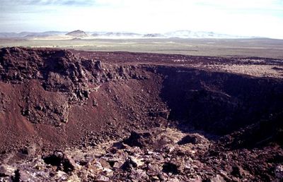
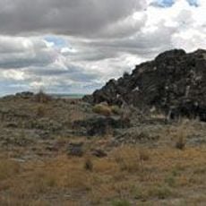
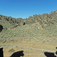
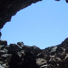
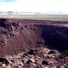
Black Butte Crater Lava Field is a volcanic formation dominated by a central crater with walls reaching up to 30 meters high on the northeast edge. The surrounding terrain consists of hardened basalt flows that create a rough, wave-like surface across the entire area.

The lava flows were created by a volcanic eruption roughly 12,000 years ago that spread basalt across a vast distance to the south and west. This eruption permanently altered the drainage patterns of the Big Wood and Little Wood Rivers.

The Nez Perce and other tribes of the Snake River Plain have used this landscape as a hunting ground and navigation landmark for countless generations.

Wear sturdy shoes with good grip when visiting, as the ground is covered with sharp basalt fragments that can easily injure unprotected feet. Move carefully and deliberately across the rough terrain to avoid slips and injuries from the jagged surface.

The lava flows forced both the Big Wood and Little Wood Rivers to change their courses, meeting about 40 kilometers west of where they originally joined together. This dramatic rerouting reveals the immense power of the eruption and how it permanently reshaped the region's geography.

Location: Lincoln County

GPS coordinates: 43.00931,-114.29170

Latest update: December 10, 2025 15:46

Photos
Around this place
Wilson Butte Cave
United States of America

Wilson Butte Cave

25.8 km
Magic Reservoir
United States of America

Magic Reservoir

31 km
Little City of Rocks Wilderness Study Area
United States of America

Little City of Rocks Wilderness Study Area

34.5 km
Schubert Theatre
United States of America

Schubert Theatre

35 km
Manuel Silva Barn
United States of America

Manuel Silva Barn

10.8 km
Jerome Cooperative Creamery
United States of America

Jerome Cooperative Creamery

37 km
Jack Oughton House
United States of America

Jack Oughton House

12.1 km
Jerome City Pump House
United States of America

Jerome City Pump House

36.5 km
Greer and Jennie Quay House
United States of America

Greer and Jennie Quay House

32.2 km
American Legion Hall
United States of America

American Legion Hall

12.6 km
Custer Slaughter House
United States of America

Custer Slaughter House

12.1 km
Jerome County Courthouse
United States of America

Jerome County Courthouse

36.4 km
James Bothwell Water Tank House
United States of America

James Bothwell Water Tank House

32.5 km
Jose and Gertrude Anasola House
United States of America

Jose and Gertrude Anasola House

12.1 km
Galo Arambarri Boarding House
United States of America

Galo Arambarri Boarding House

12.2 km
Frank J. Brick House
United States of America

Frank J. Brick House

36.1 km
Thompson Mortuary Chapel
United States of America

Thompson Mortuary Chapel

35.2 km
E. C. Gleason House
United States of America

E. C. Gleason House

36.7 km
Denton J. Paul Water Tank
United States of America

Denton J. Paul Water Tank

11.9 km
Thomas J. Kehrer House
United States of America

Thomas J. Kehrer House

28.9 km
Joseph Mandl House
United States of America

Joseph Mandl House

35.6 km
George V. Doughty House and Garage
United States of America

George V. Doughty House and Garage

29.4 km
Wood River Center Grange No. 87
United States of America

Wood River Center Grange No. 87

15.3 km
Don Tooley House
United States of America

Don Tooley House

29.9 km
Shoshone Ice Caves
United States of America

Shoshone Ice Caves

17.9 km
John F. Schmerschall House
United States of America

John F. Schmerschall House

36.6 km
James H. Laine Barn
United States of America

James H. Laine Barn

12 km
Black Butte
United States of America

Black Butte

20.2 km
Show the full map
Reviews

Visited this place? Tap the stars to rate it and share your experience / photos with the community! Try now! You can cancel it anytime.

« Black Butte Crater Lava Field - Volcanic formation in Lincoln County, Idaho, United States » is provided by Around Us (aroundus.com). Images and texts are derived from Wikimedia project under a Creative Commons license. You are allowed to copy, distribute, and modify copies of this page, under the conditions set by the license, as long as this note is clearly visible.

Discover hidden gems everywhere you go!

From secret cafés to breathtaking viewpoints, skip the crowded tourist spots and find places that match your style. Our app makes it easy with voice search, smart filtering, route optimization, and insider tips from travelers worldwide. Download now for the complete mobile experience.

Around Us App Screenshot

A unique approach to discovering new places

Le Figaro

All the places worth exploring

France Info

A tailor-made excursion in just a few clicks

20 Minutes