Chest opened
+${chestReward.xp} XP
Explorer
NOUVEAU ×${chestReward.collectible.quantity}
tapez pour fermer
Chest locked

Open chests in the app

Around Us is built for your phone — chests unlock when you walk, explore and capture nearby places.

Enable Location

We need your location to show you interesting places around you

Discover nearby places

Find interesting locations and hidden gems around you

Precise directions

Get accurate directions and distances to places

Your location is never shared with other users. It's only used when you tap the location button.

Log in to your account

Start exploring — it's free

Trusted by 72,886 travelers worldwide

Continue with Google
Continue with Apple
or

We will send you a code to connect

By continuing, you accept our Terms and Conditions and our Privacy Policy

Check your inbox

We've sent a pincode in your inbox. Please enter the code below.

Maple Street Bridge
Discussion Reviews Photo
1.6k Popularity

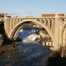
Maple Street Bridge, Road bridge over Spokane River in Washington, United States

Maple Street Bridge is a road bridge spanning the Spokane River and linking the West Central area to Downtown Spokane. The structure provides four vehicle lanes plus a separate, protected pedestrian pathway for walkers crossing on foot.

The bridge opened in 1958 and initially operated as a toll facility. The toll system was discontinued in 1990, making the crossing free for all users.

The structure connects the West Central neighborhood to Downtown Spokane, forming part of the city's network of river crossings alongside Division Street and Monroe Street bridges.

The bridge handles heavy daily traffic, and the pedestrian pathway is specifically designed for foot traffic. Visitors should expect steady traffic flow during daytime hours.

For its first decades, drivers paid tolls that increased multiple times before the fees were removed. These toll revenues originally funded the bridge's upkeep and operating expenses.

The community of curious travelers

AroundUs brings together thousands of curated places, local tips, and hidden gems, enriched daily by 60,000 contributors worldwide.

Start exploring
GPS coordinates
47.66070,-117.43520
Latest update
December 14, 2025 13:02
Around this place
The Davenport Hotel
United States of America

The Davenport Hotel

945 m
Riverfront Park
United States of America

Riverfront Park

1.2 km
Spokane Falls
United States of America

Spokane Falls

774 m
Lewis and Clark High School
United States of America

Lewis and Clark High School

1.5 km
Monroe Street Bridge
United States of America

Monroe Street Bridge

615 m
Fox Theatre
United States of America

Fox Theatre

734 m
Riverfront Park Carousel
United States of America

Riverfront Park Carousel

1.1 km
Patsy Clark Mansion
United States of America

Patsy Clark Mansion

893 m
Northwest Museum of Arts and Culture
United States of America

Northwest Museum of Arts and Culture

904 m
INB Performing Arts Center
United States of America

INB Performing Arts Center

1.3 km
Cathedral of Our Lady of Lourdes
United States of America

Cathedral of Our Lady of Lourdes

584 m
Benewah Milk Bottle
United States of America

Benewah Milk Bottle

912 m
Bing Crosby Theater
United States of America

Bing Crosby Theater

853 m
Spokane County Courthouse
United States of America

Spokane County Courthouse

667 m
Montvale Hotel
United States of America

Montvale Hotel

789 m
Central Steam Heat Plant
United States of America

Central Steam Heat Plant

1 km
Spokane Flour Mill
United States of America

Spokane Flour Mill

1.1 km
Review Building
United States of America

Review Building

736 m
Grace Baptist Church
United States of America

Grace Baptist Church

520 m
Empire State Building
United States of America

Empire State Building

889 m
Riverside Avenue Historic District
United States of America

Riverside Avenue Historic District

592 m
Amman
United States of America

Amman

432 m
Coolidge–Rising House
United States of America

Coolidge–Rising House

1.5 km
John A. Finch Memorial Nurses Home
United States of America

John A. Finch Memorial Nurses Home

1.5 km
Old National Bank Building
United States of America

Old National Bank Building

1.2 km
Campbell House
United States of America

Campbell House

977 m
City Ramp Garage
United States of America

City Ramp Garage

1.3 km
Riverfront Park Clock Tower
United States of America

Riverfront Park Clock Tower

1.2 km
Show the full map
Reviews
Share your experience

No review yet

Discussions
Start a discussion...

No discussion yet

« Maple Street Bridge - Road bridge over Spokane River in Washington, United States » is provided by Around Us (aroundus.com). Images and texts are derived from Wikimedia project under a Creative Commons license. You are allowed to copy, distribute, and modify copies of this page, under the conditions set by the license, as long as this note is clearly visible.

Discover hidden gems everywhere you go!

From secret cafés to breathtaking viewpoints, skip the crowded tourist spots and find places that match your style. Our app makes it easy with voice search, smart filtering, route optimization, and insider tips from travelers worldwide. Download now for the complete mobile experience.

Around Us App Screenshot

A unique approach to discovering new places

Le Figaro

All the places worth exploring

France Info

A tailor-made excursion in just a few clicks

20 Minutes

Around Us
Travel Guide & Maps
Download

Send to your phone

QR Code
1

Open the camera app on your mobile.

2

Point at the QR code with your camera. A notification will appear.

3

Tap the notification to open the link.