Enable Location

We need your location to show you interesting places around you

Discover nearby places

Find interesting locations and hidden gems around you

Precise directions

Get accurate directions and distances to places

Your location is never shared with other users. It's only used when you tap the location button.

Randall County

Log in to your account

Start exploring — it's free

Trusted by 62,059 travelers worldwide

Continue with Google
Continue with Apple
or

We will send you a code to connect

By continuing, you accept our Terms and Conditions and our Privacy Policy

Check your inbox

We've sent a pincode in your inbox. Please enter the code below.

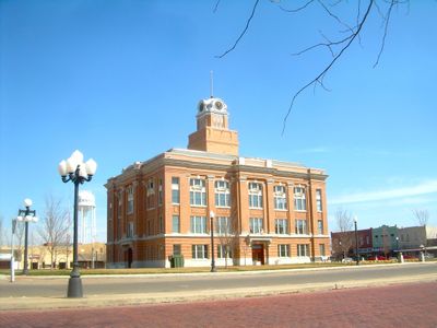
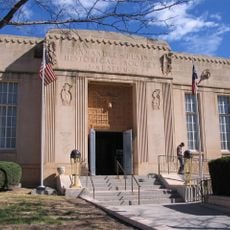
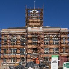
Randall County, County administration center in Canyon, Texas

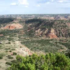
Randall County is an administrative region in the Texas Panhandle characterized by rolling grasslands and dramatic canyon formations carved into the terrain. The landscape varies in elevation across its extent, creating diverse natural features throughout the area.

The Texas Legislature established this county in 1876 and named it after a Confederate military officer, though historical records show a spelling variation in the original documentation. The area began developing as settlers moved into the Texas Panhandle region during the late 1800s.

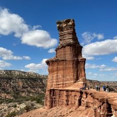
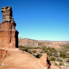
The area's landscape is shaped by the Prairie Dog Town Fork of the Red River, which has created distinctive canyon features visible across the region. These natural formations remain central to how residents and visitors experience and move through the countryside.

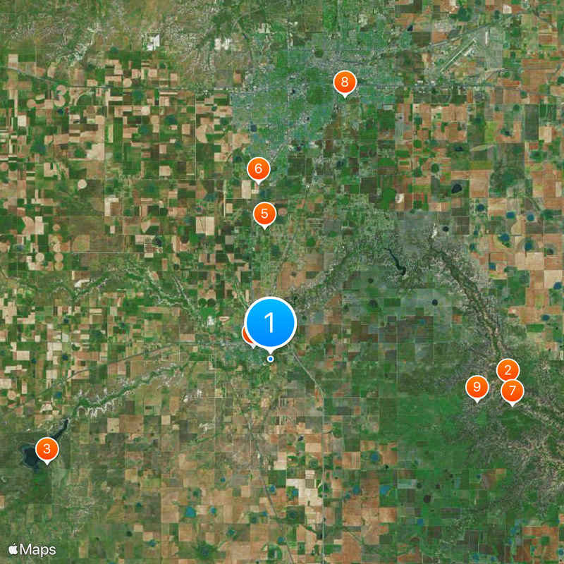
The main town is accessible by several major highways that provide connections across the region in different directions. Visitors should plan on having a vehicle, as the area is spread across a large geographic space with limited public transportation.

The region contains one of the largest and most impressive canyon systems in the United States, with walls that plunge hundreds of feet into the landscape. This natural formation sets the area apart dramatically from the surrounding flat terrain.

The community of curious travelers

AroundUs brings together thousands of curated places, local tips, and hidden gems, enriched daily by 60,000 contributors worldwide.

Start exploring
Location
Inception
1889
Capital city
Canyon
Shares border with
Armstrong County, Swisher County, Potter County, Deaf Smith County, Castro County, Oldham County, Carson County
GPS coordinates
34.97000,-101.90000
Latest update
December 20, 2025 14:40
Around this place
Palo Duro Canyon
United States of America

Palo Duro Canyon

21.4 km
Buffalo Lake National Wildlife Refuge
United States of America

Buffalo Lake National Wildlife Refuge

22.1 km
Panhandle–Plains Historical Museum
United States of America

Panhandle–Plains Historical Museum

1.9 km
Maxwell's Pumpkin Farm
United States of America

Maxwell's Pumpkin Farm

11.8 km
Sports World
United States of America

Sports World

15.9 km
Palo Duro State Park
United States of America

Palo Duro State Park

22.1 km
Llano Cemetery
United States of America

Llano Cemetery

24.5 km
Lighthouse Peak
United States of America

Lighthouse Peak

18.9 km
Randall County Courthouse
United States of America

Randall County Courthouse

2.7 km
United States of America

Amarillo Dillas Pro Baseball Field

23.6 km
United States of America

Palo Duro Club Lake

5.6 km
United States of America

L.T. Lester House

3.6 km
Texas Outdoor Musical
United States of America

Texas Outdoor Musical

20.1 km
United States of America

The Palisades

13.6 km
United States of America

Fortress Cliff

22.2 km
United States of America

Llano Cemetery Historic District

24.3 km
United States of America

Bivins Lake

14.5 km
United States of America

Wolflin Place Historic District

23.4 km
Amarillo Globe Dream House
United States of America

Amarillo Globe Dream House

24 km
United States of America

First National Bank Building

3.1 km
United States of America

T-Anchor Ranch Headquarters

1.9 km
United States of America

McSpadden Lake

558 m
United States of America

Shaw-Keiser House

3.1 km
United States of America

Palisades State Park Concession Building

13.1 km
United States of America

C.R. Burrow House

3.2 km
United States of America

Presbyterian Church Building

3 km
United States of America

Panhandle-Plains Museum

2 km
United States of America

Buffalo Courts; Recreation Hall

2 km
Show the full map
Administrative divisions
« Randall County - County administration center in Canyon, Texas » is provided by Around Us (aroundus.com). Images and texts are derived from Wikimedia project under a Creative Commons license. You are allowed to copy, distribute, and modify copies of this page, under the conditions set by the license, as long as this note is clearly visible.

Discover hidden gems everywhere you go!

From secret cafés to breathtaking viewpoints, skip the crowded tourist spots and find places that match your style. Our app makes it easy with voice search, smart filtering, route optimization, and insider tips from travelers worldwide. Download now for the complete mobile experience.

Around Us App Screenshot

A unique approach to discovering new places

Le Figaro

All the places worth exploring

France Info

A tailor-made excursion in just a few clicks

20 Minutes

Around Us
Travel Guide & Maps
Download

Send to your phone

QR Code
1

Open the camera app on your mobile.

2

Point at the QR code with your camera. A notification will appear.

3

Tap the notification to open the link.