Lighthouse Peak

Log in to your account

AroundUs is a community-driven map of interesting places, built by curious explorers like you. It grows with every review, story, and photo you share.
Connect to save your favorite spots, contribute locations, and create personalized routes.
Continue with Google
Continue with Apple
Continue with X
Continue with Facebook
Continue with email
By continuing, you accept our Terms and Conditions and our Privacy Policy
Create an account
Add to collection
Map
Suggest a change
Share

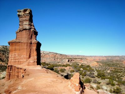
Lighthouse Peak, Rock formation in Palo Duro Canyon State Park, Texas, US.

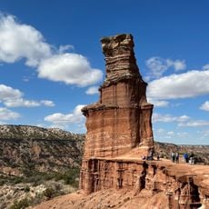
Lighthouse Peak is a 296-foot-tall rock formation in Palo Duro Canyon with clearly visible layers of sedimentary stone stacked vertically. The surface displays natural erosion patterns created over millions of years by water flow and weathering.

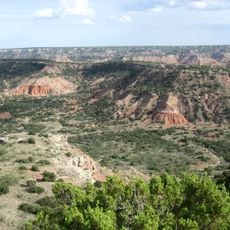
The formation developed over millions of years through erosion of ancient marine sediments that accumulated when the Texas Panhandle was covered by ocean. Geological processes gradually carved out the layered rock structure visible today.

The formation draws photographers and observers who come to capture how the rock face changes color throughout the day. People gather here to watch the light play across the layered stone surfaces at different times.

The trail to the formation is moderately challenging and requires plenty of water and an early morning start to avoid afternoon heat. The best time to visit is during cooler months when conditions on the exposed path are more comfortable.

The rock formation creates distinctive wind patterns through its crevices and gaps that generate characteristic sounds when air passes through. This natural phenomenon is especially noticeable on breezy days and often goes unnoticed by visitors despite being memorable.

Location: Randall County

GPS coordinates: 34.93644,-101.69685

Latest update: December 6, 2025 19:07

Photos
Hidden places in Texas

Texas combines landscapes that barely resemble each other. The west spreads out in deserts and sand dunes, while the east is marked by swamps and dense forests. Between these extremes lie limestone cliffs, natural springs, and waterfalls that bubble up from the ground. The size of the state allows...

Around this place
Cadillac Ranch
United States of America

Cadillac Ranch

38.5 km
Palo Duro Canyon
United States of America

Palo Duro Canyon

3.1 km
United States of America

National Helium Reserve

36.8 km
United States of America

American Quarter Horse Hall of Fame

30.4 km
JA Ranch
United States of America

JA Ranch

48.3 km
Don Harrington Discovery Center
United States of America

Don Harrington Discovery Center

35.3 km
Amarillo Civic Center
United States of America

Amarillo Civic Center

32.8 km
Atchison, Topeka and Santa Fe Railway 5000
United States of America

Atchison, Topeka and Santa Fe Railway 5000

32.9 km
Wonderland Park
United States of America

Wonderland Park

36 km
Buffalo Lake National Wildlife Refuge
United States of America

Buffalo Lake National Wildlife Refuge

39 km
Chase Tower
United States of America

Chase Tower

32.8 km
Santa Fe Building
United States of America

Santa Fe Building

32.5 km
Panhandle–Plains Historical Museum
United States of America

Panhandle–Plains Historical Museum

20.7 km
Amarillo National Bank Sox Stadium
United States of America

Amarillo National Bank Sox Stadium

31.5 km
Texas Air & Space Museum
United States of America

Texas Air & Space Museum

31.1 km
Texas Tornado
United States of America

Texas Tornado

36.4 km
Amarillo Museum of Art
United States of America

Amarillo Museum of Art

31.2 km
Charles and Mary Ann Goodnight Ranch House
United States of America

Charles and Mary Ann Goodnight Ranch House

48 km
Potter County Courthouse
United States of America

Potter County Courthouse

32.8 km
Sacred Heart Cathedral
United States of America

Sacred Heart Cathedral

32.4 km
J. Marvin Jones Federal Building and United States Courthouse
United States of America

J. Marvin Jones Federal Building and United States Courthouse

32.8 km
Courtyard by Marriott, Downtown Amarillo
United States of America

Courtyard by Marriott, Downtown Amarillo

32.6 km
Palo Duro State Park
United States of America

Palo Duro State Park

3.2 km
Llano Cemetery
United States of America

Llano Cemetery

29.8 km
Randall County Courthouse
United States of America

Randall County Courthouse

21.6 km
Amarillo Natatorium
United States of America

Amarillo Natatorium

34.3 km
Texas Outdoor Musical
United States of America

Texas Outdoor Musical

4.6 km
Amarillo Globe Dream House
United States of America

Amarillo Globe Dream House

30.3 km
Show the full map
Reviews

Visited this place? Tap the stars to rate it and share your experience / photos with the community! Try now! You can cancel it anytime.

« Lighthouse Peak - Rock formation in Palo Duro Canyon State Park, Texas, US » is provided by Around Us (aroundus.com). Images and texts are derived from Wikimedia project under a Creative Commons license. You are allowed to copy, distribute, and modify copies of this page, under the conditions set by the license, as long as this note is clearly visible.

Discover hidden gems everywhere you go!

From secret cafés to breathtaking viewpoints, skip the crowded tourist spots and find places that match your style. Our app makes it easy with voice search, smart filtering, route optimization, and insider tips from travelers worldwide. Download now for the complete mobile experience.

Around Us App Screenshot

A unique approach to discovering new places

Le Figaro

All the places worth exploring

France Info

A tailor-made excursion in just a few clicks

20 Minutes