See the monuments around you in AROpen chests in the app
Around Us is built for your phone — point your camera at the streets and discover the monuments and places around you in augmented reality.Around Us is built for your phone — chests unlock when you walk, explore and capture nearby places.
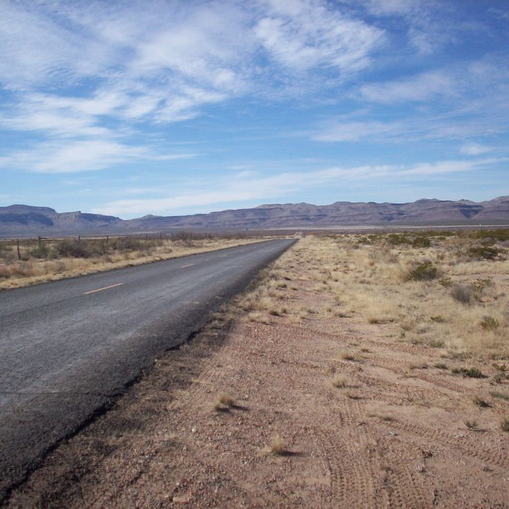
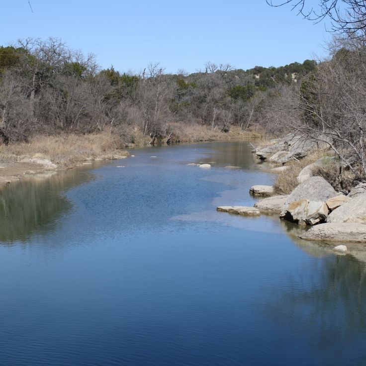
Texas combines landscapes that barely resemble each other. The west spreads out in deserts and sand dunes, while the east is marked by swamps and dense forests. Between these extremes lie limestone cliffs, natural springs, and waterfalls that bubble up from the ground. The size of the state allows for this variety. A traveler can hike through dry canyons one day and wade through marshland the next.
The state preserves places from different chapters of history. Spanish missions built in the 18th century stand near Native American quarries used for thousands of years. Mining towns and military forts from the 1800s now sit empty, their wooden structures weathered by sun and wind. Plantation houses with wide porches remain from before the Civil War. Visitors can also find a Japanese garden in San Antonio, a replica of Stonehenge in the Hill Country, and underwater caves where divers explore submerged passages. The variety makes it possible to see ancient footprints, colonial architecture, and ghost towns in the same trip.
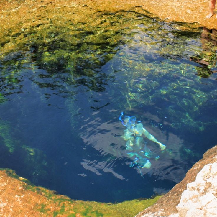
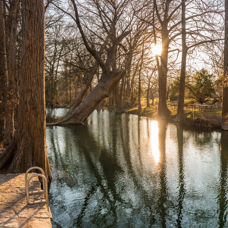
This vertical underwater passage sits in the Wimberley area and opens from a spring pool into several chambers that reach deep into the rock. Jacob's Well is one of the natural features in Texas where the water stays clear and the limestone walls allow daylight only in the upper sections. The first chambers still receive sunlight, while the deeper parts remain in total darkness. Local divers know the layout of the individual rooms and passageways that extend more than 130 feet (about 40 meters) down. The clear spring water flows year-round, and the setting feels like a quiet refuge between woods and dry hill country.
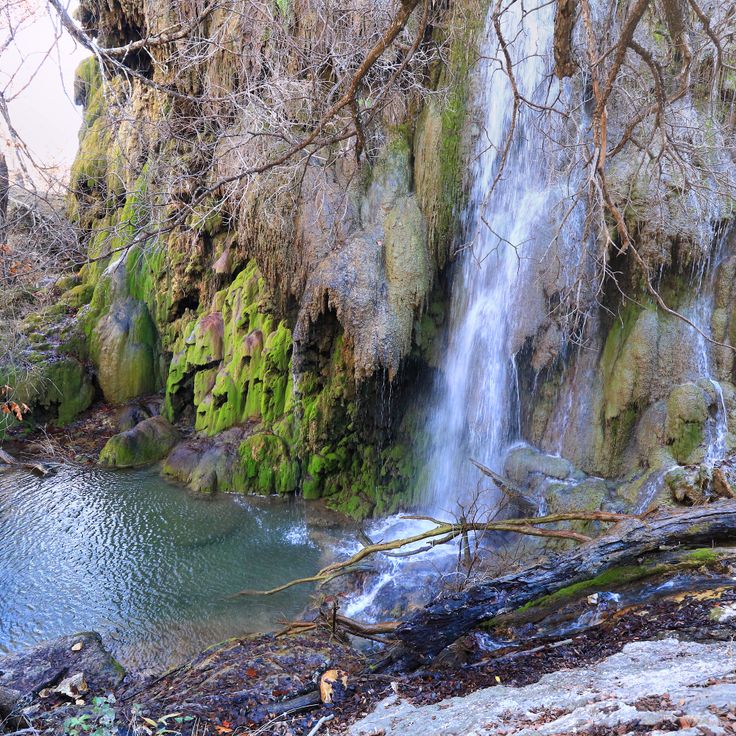
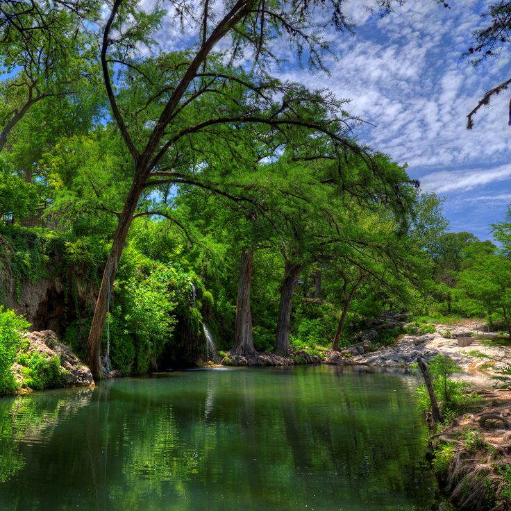
This waterfall sits within Colorado Bend State Park and drops down a limestone wall covered with moss and ferns. The water flows year-round, fed by a spring above. Access requires a hike along a trail through the park. The rock face shows layers from different geological periods. Visitors walk through wooded terrain before the falls come into view.
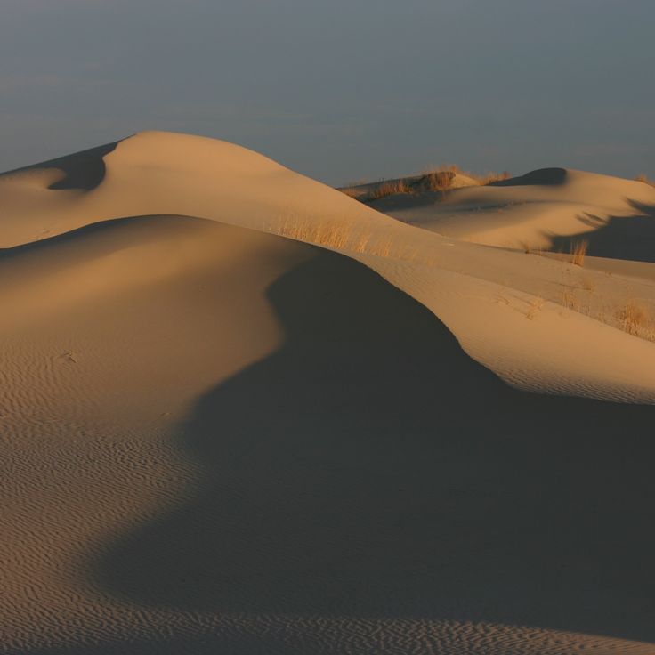
This state park shows sand dunes in different stages. Some move with the wind, while others stay in place through grasses and low plants. The surface shifts between smooth slopes and textured ridges. Visitors can walk on the sand or slide down it using boards. The setting is dry and open, with few trees along the edge. The terrain sits between flat plains in West Texas.
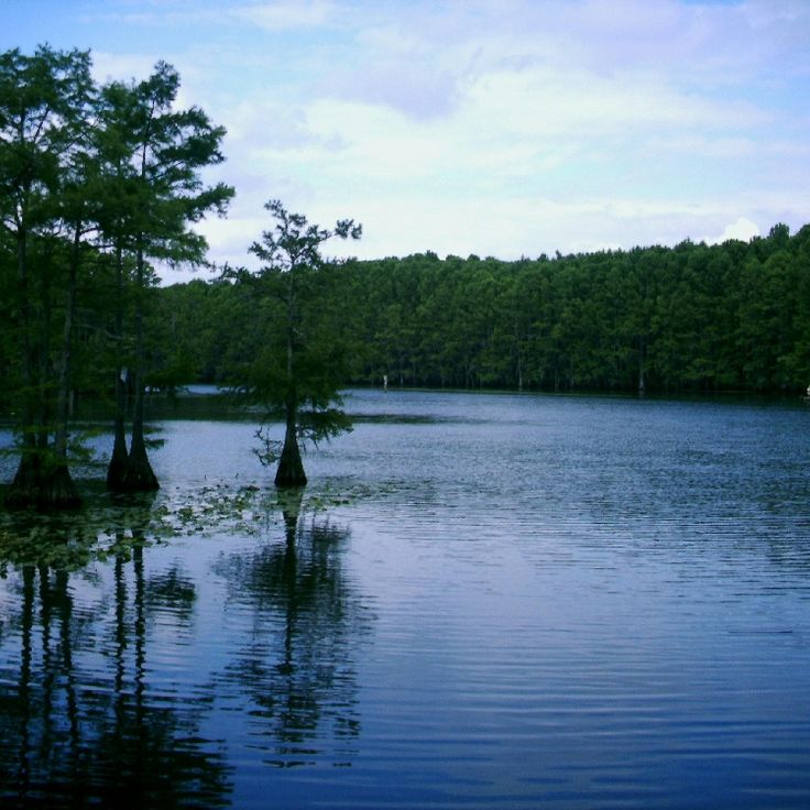
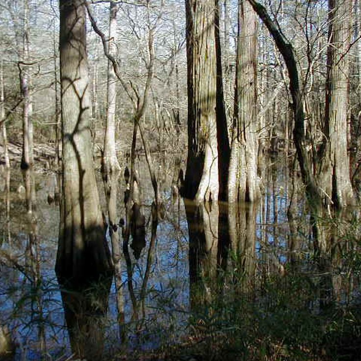
This lake in northeast Texas offers one of the few natural freshwater lakes in the state. Swamp cypresses grow directly from the water and form shaded passages between the tree trunks. Alligators live in the shallow areas, while water birds nest among the branches. The water flows slowly through winding channels lined with moss-draped trees. Boaters move through narrow passages where vegetation stands thick and sunlight filters softly through the leaves.
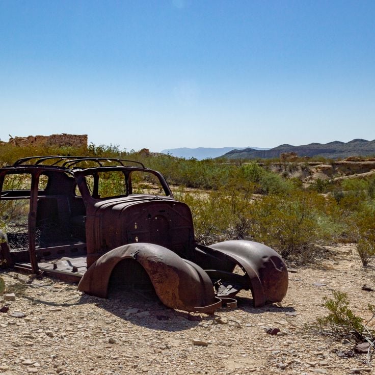
This former mining settlement sits in the Big Bend Country desert. The stone and adobe ruins have stood empty since the 1940s, when mercury extraction ended. Cactus and mesquite grow between the crumbling houses. The cemetery with its wrought-iron fences overlooks the dry valley. Some buildings have been converted into shops and restaurants that draw travelers heading to the national park. The roofless church still stands on the hill.
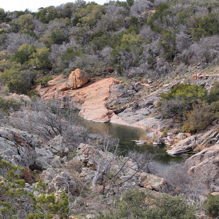
This natural inlet at Inks Lake State Park sits between limestone walls that rise up to 100 feet. The water reaches depths of about 15 feet. The spot shows the geology of this part of Texas, where rivers have cut through limestone over time. Visitors swim here or jump from the rocks into the water. The walls cast shadows across the surface, especially in the morning and late afternoon.
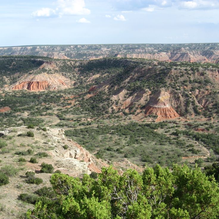
This canyon sits in the Texas Panhandle and forms the second largest gorge in the United States. The rock walls show red, yellow and orange layers of sandstone formed over millions of years. Trails lead through mesquite forests and along dry creek beds. In the morning and evening the rocks cast long shadows across the valley. Wildflowers grow after rains between the stones.
This viewing station sits in the desert of far West Texas and provides access to a light phenomenon documented since the 1880s. After dark, mysterious lights appear on the horizon, changing position and color, splitting apart or merging together. The cause of the lights remains unexplained. The station includes a parking area, information panels and a raised viewing platform. Visitors arrive after sunset to witness the lights firsthand and form their own impression of this natural occurrence.
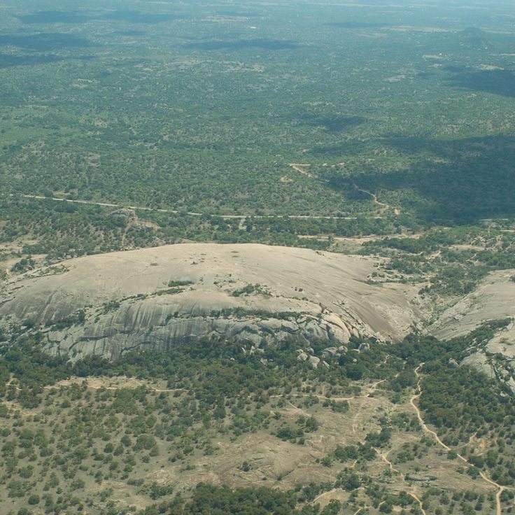
Granite Rock is a monolith of pink granite that rises 425 feet (130 meters) above the plain. From this rock, the view reaches to the horizon. The surface shows the weathering patterns typical of granite. The climb follows natural fissures and smooth surfaces. In some places, rainwater collects in shallow depressions. The surrounding area consists of grassland with scattered trees. At sunrise and sunset, the stone turns pink to orange.
This natural swimming pool sits between limestone rocks and draws water from an underground spring. Old cypress trees line the shore. Blue Hole Park is among the natural springs in Texas, where the terrain shifts from desert to swampland and visitors can explore limestone cliffs and historic sites.
Krause Springs is a private property with 32 springs that flow into several natural pools. The water comes cold from the ground and collects in different pools among trees and rocks. The setting shows typical Texas vegetation with cedars and oaks, and the place sits away from main roads in a quiet area. Visitors can camp and use the springs, which run year-round and are part of the natural landscape of the Texas Hill Country.
This former cotton settlement sits empty in the western desert of the state. The buildings date from the 1920s, when farmers grew cotton here and trains passed along the tracks. Today only ruins remain: a school with hollow windows, an old store, houses without roofs. Wind blows through the rooms. Nothing moves between the walls. Abandoned Lobo shows how quickly a settlement can disappear when water runs out and the railroad changes its route.
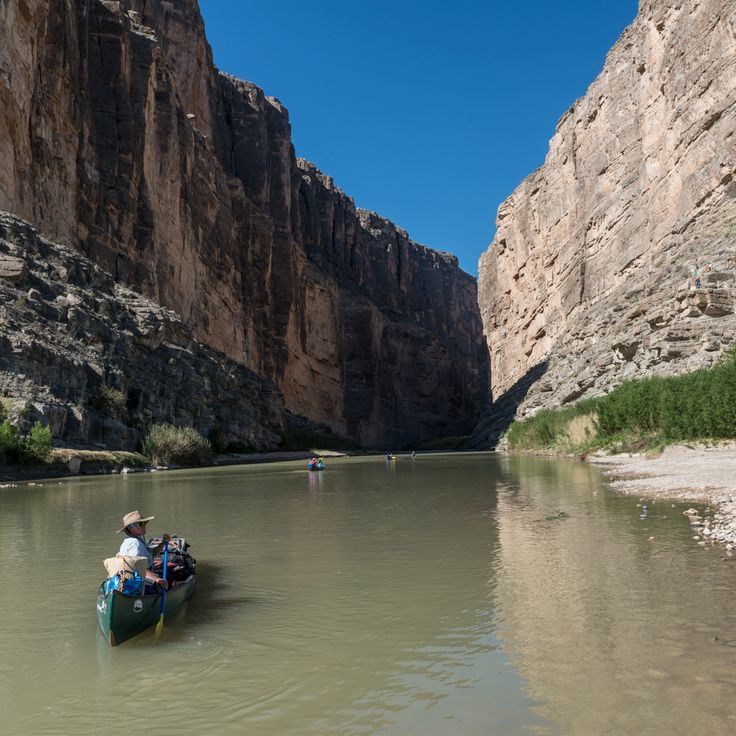
This canyon shows how the Rio Grande has cut through limestone rock between the United States and Mexico over thousands of years. Vertical rock faces rise about 1,500 feet (460 meters) on both sides of the river. A trail leads into the canyon where the walls block sunlight for several hours during the day. The river flows through this narrow passage, creating a corridor between the tall cliffs. The formation is part of the natural terrain Texas offers with its geological features.
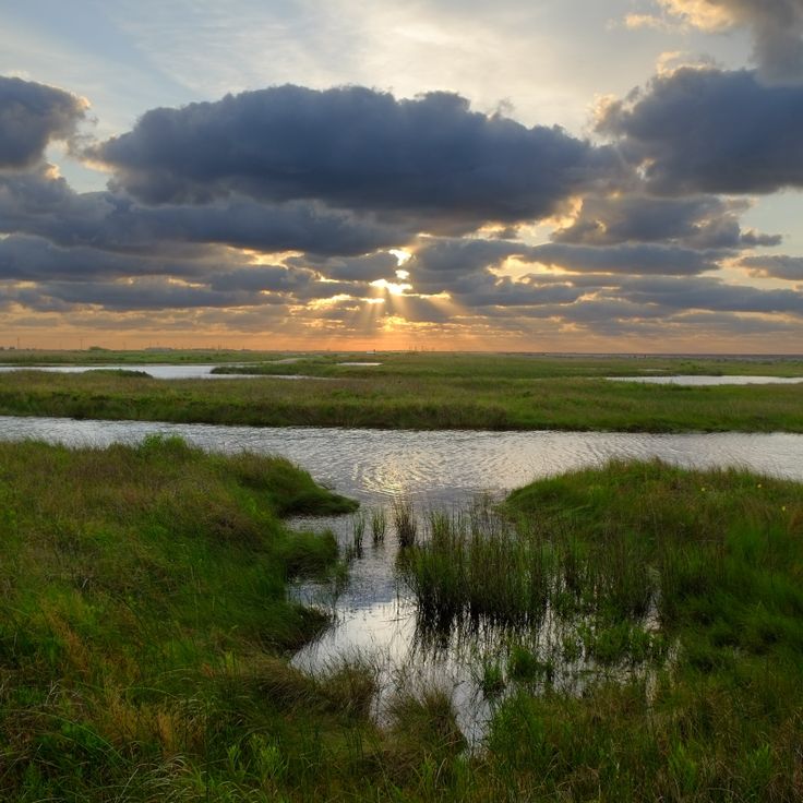
This park sits along the Gulf of Mexico and connects salt marshes with sandy beach. Sea Rim State Park stretches along the coast and offers paths through flat marshland where migratory birds rest in spring and fall. The water is warm and murky, the sand hard and dark. You can walk between dunes and grasses, watch birds, or swim in the shallow sea. The wind blows almost constantly, and the landscape feels flat and wide.
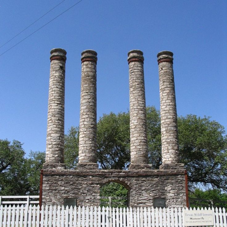
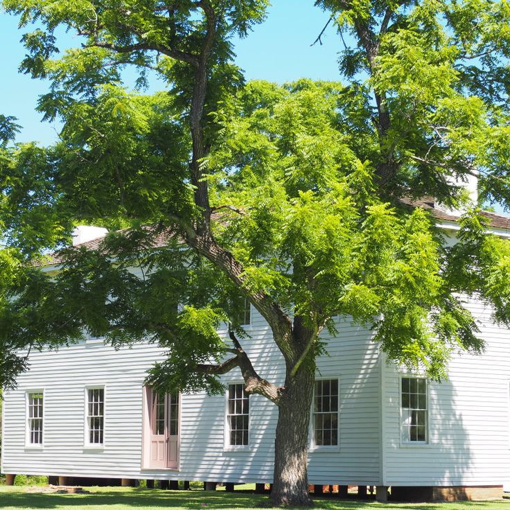
This historical site displays four columns from the former Baylor Female College, which opened in 1846. The columns stand as remnants of one of the first institutions of higher learning for women in Texas and recall the educational history of the state. The park sits in a quiet rural area where the white columns rise between trees and grass. Visitors come here to sense the connection to pioneer-era Texas and to experience a place that speaks of the development of women's education during the 19th century.
This park in the Texas high plains shows red sandstone cliffs rising above wide grasslands. A herd of 140 wild bison lives on the 15,000-acre (6,000-hectare) grounds, roaming through canyons and open prairie. Trails run along cliff edges and down into gorges where prairie grasses bend in the wind. Mornings and evenings bring the bison through the valleys. The landscape shifts between flat mesas and deep cuts in the rock. The park is among the remote natural places in Texas where desert forms meet prairie country.
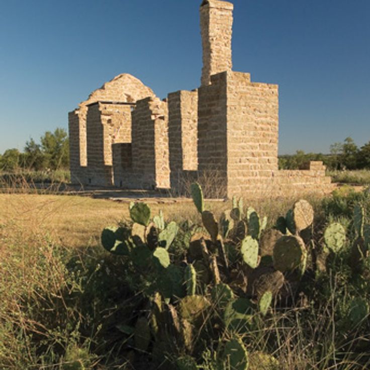
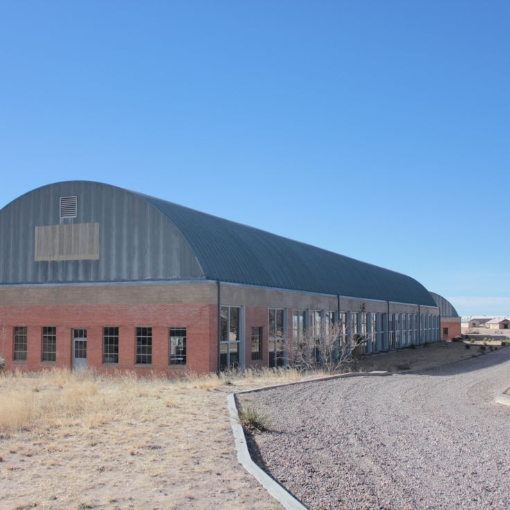
This military installation dates back to 1867 and sits on a hill above the river. The walls made of stone remain in part. Soldiers lived here until 1881 and protected settlers from attacks. The museum displays objects from daily troop life. Ruins of buildings mark the former structure of the fort. A settlement with traders and buffalo hunters grew nearby. The place gives a sense of life on the 19th-century Texas frontier.
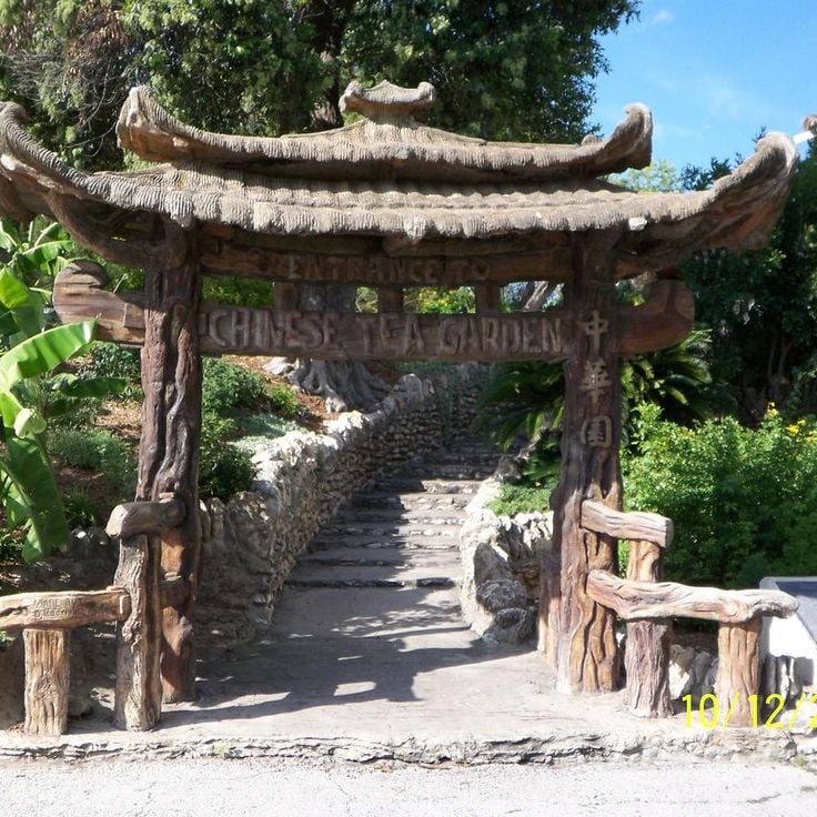
This botanical garden sits in a former quarry and brings together Asian garden traditions with Texas history. The grounds contain a tea pavilion, several ponds with koi carp, and stone bridges that cross the water. The planting follows Japanese principles with bamboo, maple, and cherry trees. The garden was created in the early 20th century and uses the natural rock of the quarry as a backdrop. Visitors can walk along winding paths, sit beside still pools, and watch the carp move slowly through the water. The mood is quiet, the plants grow close together, and the stone frames every view.
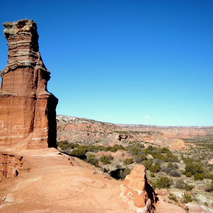
This red sandstone pillar in Palo Duro Canyon State Park rises 300 feet from the canyon floor and formed through millions of years of wind and water erosion. The rock formation lies about a hike from the valley bottom and shows layered sedimentary bands ranging from orange to reddish brown. The shape resembles a tall lighthouse and stands out clearly from the surrounding canyon floor, while colors shift from pale rust to deep copper depending on the time of day.
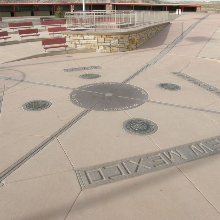
This granite marker identifies the only point in the United States where four states meet: Arizona, Colorado, New Mexico and Utah. The site sits within Navajo Nation lands, surrounded by dry plains and distant mesas. The location belongs to an area with thousands of years of indigenous history and rises more than 6,000 feet (1,800 meters) above sea level. Visitors often stand with one foot in each state while local artisans sell their work at nearby stalls. The location reflects the geological and cultural shifts that characterize Texas, from open landscapes to historic settlements.
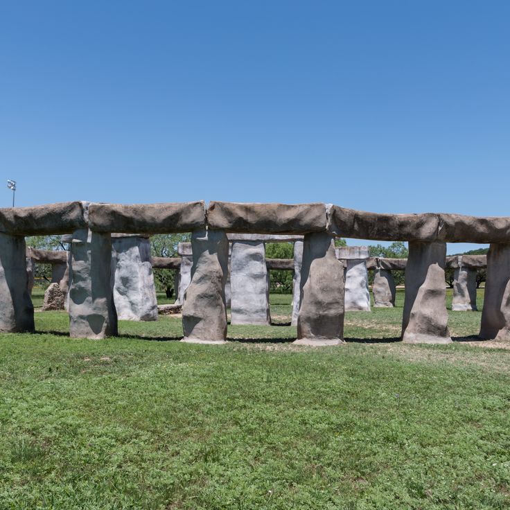
This concrete replica was built in 1989 and stands at roughly 60 percent of the scale of the original English stone circle. Moai statues stand next to the pillars, inspired by the figures of Easter Island. The site sits on open ground in the Texas hills, where it began as a private art installation. Visitors can walk between the stones and observe the proportions up close. The pairing of the stone circle with the island statues makes this an unusual roadside attraction outside the traditional Texas routes.
This historic route connects Spanish missions and trading paths from the 17th century across roughly 1,500 miles (2,400 kilometers) of Texas. The trail runs through changing landscapes from the Louisiana border to Mexico, following the tracks of Spanish colonial times. Along the way lie old settlements, river crossings and places where travelers once stopped to rest. Some sections pass through open grassland, others through wooded areas or along waterways.
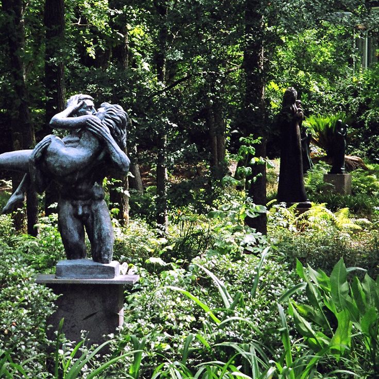
This sculpture garden in Austin displays 130 works by the American sculptor Charles Umlauf. The collection includes bronze sculptures, stone works and wood carvings placed among tall trees and along pathways. Visitors walk through a quiet outdoor space where art and nature come together. The museum sits near downtown and shows work from several decades. The pieces range from abstract forms to figures that capture human movement. Families and art lovers come here to see the sculptures outdoors.
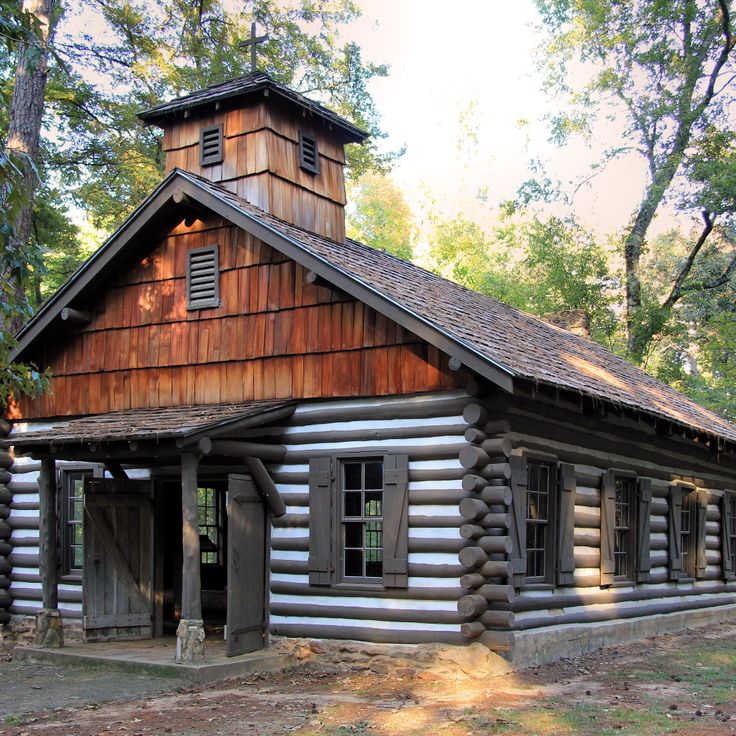
This park shows a wooden house from 1828 and a reconstruction of the first Spanish mission in Texas. The site sits in the Piney Woods, a forest area with tall pines and hardwood trees. Visitors walk trails through the grounds and see historic buildings from the colonial period. The timber structures stand among trees and clearings. The area was once home to the Caddo people and later the site of Spanish mission posts in the 17th century.
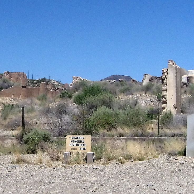
This mining settlement was founded in the 19th century and later abandoned. The buildings from that time still stand, along with the remains of the silver mine. Shafter Ghost Town sits in the desert near the Mexican border and shows how people once searched for minerals in remote areas. You can walk through the empty streets and imagine what life was like when work still took place here. The wooden and stone houses, the storefront and other structures remind visitors that this place was once a small community before the silver ran out and residents moved away.
This park protects fossil dinosaur tracks in the Paluxy River bed. The prints date from the Cretaceous period, when large reptiles walked through shallow water. When water levels drop, the tracks become visible in the limestone. The site sits in Texas, where landscapes shift from deserts to wetlands. Visitors can walk to the locations in the river and see the triangular footprints left by the animals. The tracks show where dinosaurs moved millions of years ago.
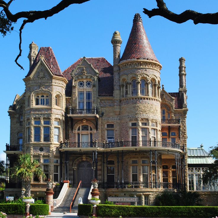
This mansion from 1892 shows the architecture of the Victorian era in Texas. The facade uses cut stone, and inside there are hand-carved wood panels. The windows contain colored glass from the period. The Bishop's Palace is among the historic buildings in Galveston that document the lives of wealthy families along the Gulf of Mexico in the late 19th century.
The Chinati Foundation occupies a former military base in the West Texas desert. Fifteen buildings from World War II now house large-scale installations and sculptures. Many works were created specifically for these spaces. The site covers 340 acres of open land. Long barracks and warehouses serve as exhibition halls. Visitors move between the structures and experience art in dialogue with architecture and landscape. The setting is quiet and expansive. The foundation reflects a vision of art inseparable from the place it inhabits.
This 1848 plantation shows daily life and farm labor in Texas before the Civil War. The site sits in flat land near the coast, where cotton and sugar cane once grew. Visitors see remains of buildings where enslaved people lived and worked. Archaeological finds reveal their religious practices and everyday routines. The plantation is among the historic sites that show how the land changed from slavery to freedom.
This preserve in southeastern Texas includes wetlands, pine forest and cypress woods that bring together different natural areas within a small region. Visitors find trails through thick vegetation, quiet streams and swampy zones with ferns and orchids. The area is home to alligators, woodpeckers and rare beetle species, while the landscape shifts from green to rust-red depending on the season.
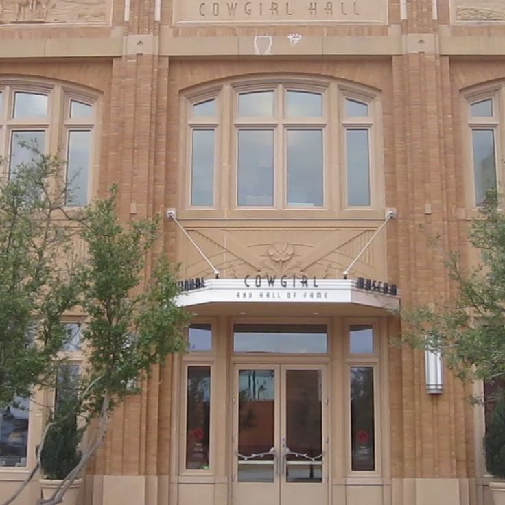
The National Cowgirl Museum and Hall of Fame holds belongings and stories from women who shaped the American West. The collection includes clothing, saddles, personal items, and documents spanning several centuries. Visitors learn about ranchers, rodeo riders, writers, and businesswomen. Exhibition rooms connect historical objects with accounts of daily life on the frontier. Photographs and film clips accompany the displays. The museum sits in Fort Worth, a city with a long cattle-raising history.
This archaeological site in northern Texas preserves quarries used by indigenous peoples for 13000 years. They extracted flint, a material valued for its hardness and sharp edges when fractured, to craft tools and weapons. The Alibates Flint Quarries National Monument spreads across hills where traces of ancient quarrying remain visible today. Visitors walk trails through dry terrain, passing reddish stone formations and remnants of prehistoric activity. The area offers a view into how people harvested raw materials across millennia. Rangers lead tours explaining the geology and techniques used to work the stone.
This vertical underwater passage sits in the Wimberley area and opens from a spring pool into several chambers that reach deep into the rock. Jacob's Well is one of the natural features in Texas where the water stays clear and the limestone walls allow daylight only in the upper sections. The first chambers still receive sunlight, while the deeper parts remain in total darkness. Local divers know the layout of the individual rooms and passageways that extend more than 130 feet (about 40 meters) down. The clear spring water flows year-round, and the setting feels like a quiet refuge between woods and dry hill country.
This waterfall sits within Colorado Bend State Park and drops down a limestone wall covered with moss and ferns. The water flows year-round, fed by a spring above. Access requires a hike along a trail through the park. The rock face shows layers from different geological periods. Visitors walk through wooded terrain before the falls come into view.
This state park shows sand dunes in different stages. Some move with the wind, while others stay in place through grasses and low plants. The surface shifts between smooth slopes and textured ridges. Visitors can walk on the sand or slide down it using boards. The setting is dry and open, with few trees along the edge. The terrain sits between flat plains in West Texas.
This lake in northeast Texas offers one of the few natural freshwater lakes in the state. Swamp cypresses grow directly from the water and form shaded passages between the tree trunks. Alligators live in the shallow areas, while water birds nest among the branches. The water flows slowly through winding channels lined with moss-draped trees. Boaters move through narrow passages where vegetation stands thick and sunlight filters softly through the leaves.
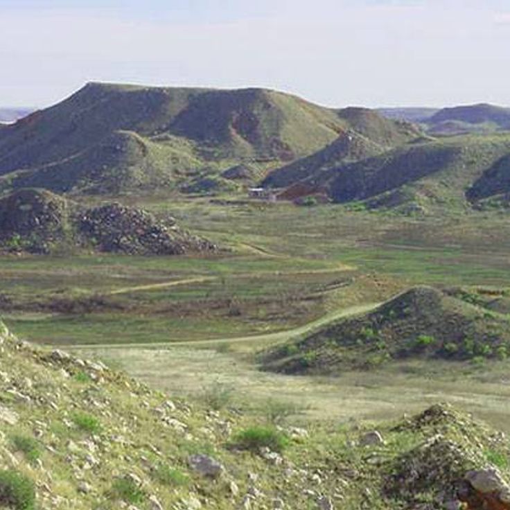
This former mining settlement sits in the Big Bend Country desert. The stone and adobe ruins have stood empty since the 1940s, when mercury extraction ended. Cactus and mesquite grow between the crumbling houses. The cemetery with its wrought-iron fences overlooks the dry valley. Some buildings have been converted into shops and restaurants that draw travelers heading to the national park. The roofless church still stands on the hill.
This natural inlet at Inks Lake State Park sits between limestone walls that rise up to 100 feet. The water reaches depths of about 15 feet. The spot shows the geology of this part of Texas, where rivers have cut through limestone over time. Visitors swim here or jump from the rocks into the water. The walls cast shadows across the surface, especially in the morning and late afternoon.
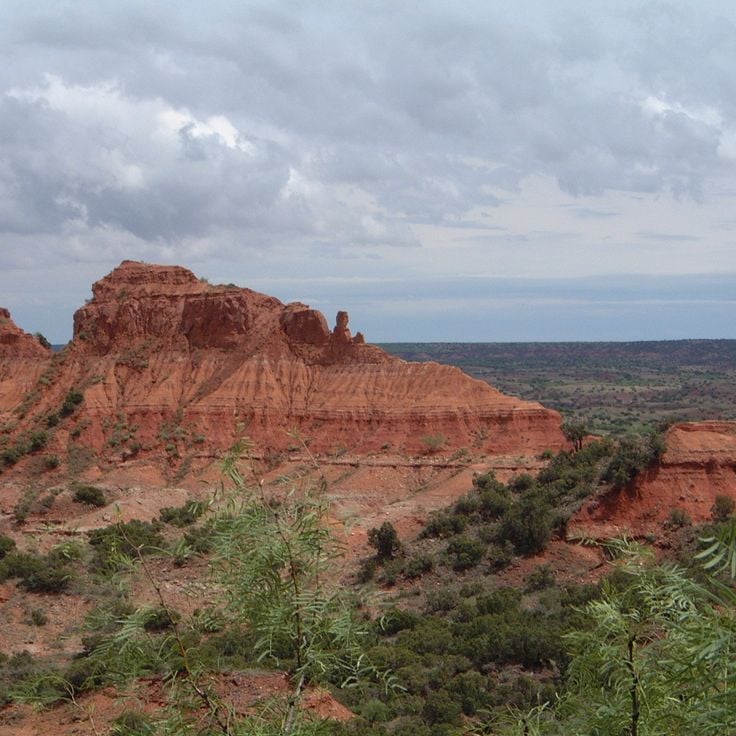
This canyon sits in the Texas Panhandle and forms the second largest gorge in the United States. The rock walls show red, yellow and orange layers of sandstone formed over millions of years. Trails lead through mesquite forests and along dry creek beds. In the morning and evening the rocks cast long shadows across the valley. Wildflowers grow after rains between the stones.
This viewing station sits in the desert of far West Texas and provides access to a light phenomenon documented since the 1880s. After dark, mysterious lights appear on the horizon, changing position and color, splitting apart or merging together. The cause of the lights remains unexplained. The station includes a parking area, information panels and a raised viewing platform. Visitors arrive after sunset to witness the lights firsthand and form their own impression of this natural occurrence.
Granite Rock is a monolith of pink granite that rises 425 feet (130 meters) above the plain. From this rock, the view reaches to the horizon. The surface shows the weathering patterns typical of granite. The climb follows natural fissures and smooth surfaces. In some places, rainwater collects in shallow depressions. The surrounding area consists of grassland with scattered trees. At sunrise and sunset, the stone turns pink to orange.
This natural swimming pool sits between limestone rocks and draws water from an underground spring. Old cypress trees line the shore. Blue Hole Park is among the natural springs in Texas, where the terrain shifts from desert to swampland and visitors can explore limestone cliffs and historic sites.
Krause Springs is a private property with 32 springs that flow into several natural pools. The water comes cold from the ground and collects in different pools among trees and rocks. The setting shows typical Texas vegetation with cedars and oaks, and the place sits away from main roads in a quiet area. Visitors can camp and use the springs, which run year-round and are part of the natural landscape of the Texas Hill Country.
This former cotton settlement sits empty in the western desert of the state. The buildings date from the 1920s, when farmers grew cotton here and trains passed along the tracks. Today only ruins remain: a school with hollow windows, an old store, houses without roofs. Wind blows through the rooms. Nothing moves between the walls. Abandoned Lobo shows how quickly a settlement can disappear when water runs out and the railroad changes its route.
This canyon shows how the Rio Grande has cut through limestone rock between the United States and Mexico over thousands of years. Vertical rock faces rise about 1,500 feet (460 meters) on both sides of the river. A trail leads into the canyon where the walls block sunlight for several hours during the day. The river flows through this narrow passage, creating a corridor between the tall cliffs. The formation is part of the natural terrain Texas offers with its geological features.
This park sits along the Gulf of Mexico and connects salt marshes with sandy beach. Sea Rim State Park stretches along the coast and offers paths through flat marshland where migratory birds rest in spring and fall. The water is warm and murky, the sand hard and dark. You can walk between dunes and grasses, watch birds, or swim in the shallow sea. The wind blows almost constantly, and the landscape feels flat and wide.
This historical site displays four columns from the former Baylor Female College, which opened in 1846. The columns stand as remnants of one of the first institutions of higher learning for women in Texas and recall the educational history of the state. The park sits in a quiet rural area where the white columns rise between trees and grass. Visitors come here to sense the connection to pioneer-era Texas and to experience a place that speaks of the development of women's education during the 19th century.
This park in the Texas high plains shows red sandstone cliffs rising above wide grasslands. A herd of 140 wild bison lives on the 15,000-acre (6,000-hectare) grounds, roaming through canyons and open prairie. Trails run along cliff edges and down into gorges where prairie grasses bend in the wind. Mornings and evenings bring the bison through the valleys. The landscape shifts between flat mesas and deep cuts in the rock. The park is among the remote natural places in Texas where desert forms meet prairie country.
This military installation dates back to 1867 and sits on a hill above the river. The walls made of stone remain in part. Soldiers lived here until 1881 and protected settlers from attacks. The museum displays objects from daily troop life. Ruins of buildings mark the former structure of the fort. A settlement with traders and buffalo hunters grew nearby. The place gives a sense of life on the 19th-century Texas frontier.
This botanical garden sits in a former quarry and brings together Asian garden traditions with Texas history. The grounds contain a tea pavilion, several ponds with koi carp, and stone bridges that cross the water. The planting follows Japanese principles with bamboo, maple, and cherry trees. The garden was created in the early 20th century and uses the natural rock of the quarry as a backdrop. Visitors can walk along winding paths, sit beside still pools, and watch the carp move slowly through the water. The mood is quiet, the plants grow close together, and the stone frames every view.
This red sandstone pillar in Palo Duro Canyon State Park rises 300 feet from the canyon floor and formed through millions of years of wind and water erosion. The rock formation lies about a hike from the valley bottom and shows layered sedimentary bands ranging from orange to reddish brown. The shape resembles a tall lighthouse and stands out clearly from the surrounding canyon floor, while colors shift from pale rust to deep copper depending on the time of day.
This granite marker identifies the only point in the United States where four states meet: Arizona, Colorado, New Mexico and Utah. The site sits within Navajo Nation lands, surrounded by dry plains and distant mesas. The location belongs to an area with thousands of years of indigenous history and rises more than 6,000 feet (1,800 meters) above sea level. Visitors often stand with one foot in each state while local artisans sell their work at nearby stalls. The location reflects the geological and cultural shifts that characterize Texas, from open landscapes to historic settlements.
This concrete replica was built in 1989 and stands at roughly 60 percent of the scale of the original English stone circle. Moai statues stand next to the pillars, inspired by the figures of Easter Island. The site sits on open ground in the Texas hills, where it began as a private art installation. Visitors can walk between the stones and observe the proportions up close. The pairing of the stone circle with the island statues makes this an unusual roadside attraction outside the traditional Texas routes.
This historic route connects Spanish missions and trading paths from the 17th century across roughly 1,500 miles (2,400 kilometers) of Texas. The trail runs through changing landscapes from the Louisiana border to Mexico, following the tracks of Spanish colonial times. Along the way lie old settlements, river crossings and places where travelers once stopped to rest. Some sections pass through open grassland, others through wooded areas or along waterways.
This sculpture garden in Austin displays 130 works by the American sculptor Charles Umlauf. The collection includes bronze sculptures, stone works and wood carvings placed among tall trees and along pathways. Visitors walk through a quiet outdoor space where art and nature come together. The museum sits near downtown and shows work from several decades. The pieces range from abstract forms to figures that capture human movement. Families and art lovers come here to see the sculptures outdoors.
This park shows a wooden house from 1828 and a reconstruction of the first Spanish mission in Texas. The site sits in the Piney Woods, a forest area with tall pines and hardwood trees. Visitors walk trails through the grounds and see historic buildings from the colonial period. The timber structures stand among trees and clearings. The area was once home to the Caddo people and later the site of Spanish mission posts in the 17th century.
This mining settlement was founded in the 19th century and later abandoned. The buildings from that time still stand, along with the remains of the silver mine. Shafter Ghost Town sits in the desert near the Mexican border and shows how people once searched for minerals in remote areas. You can walk through the empty streets and imagine what life was like when work still took place here. The wooden and stone houses, the storefront and other structures remind visitors that this place was once a small community before the silver ran out and residents moved away.
This park protects fossil dinosaur tracks in the Paluxy River bed. The prints date from the Cretaceous period, when large reptiles walked through shallow water. When water levels drop, the tracks become visible in the limestone. The site sits in Texas, where landscapes shift from deserts to wetlands. Visitors can walk to the locations in the river and see the triangular footprints left by the animals. The tracks show where dinosaurs moved millions of years ago.
This mansion from 1892 shows the architecture of the Victorian era in Texas. The facade uses cut stone, and inside there are hand-carved wood panels. The windows contain colored glass from the period. The Bishop's Palace is among the historic buildings in Galveston that document the lives of wealthy families along the Gulf of Mexico in the late 19th century.
The Chinati Foundation occupies a former military base in the West Texas desert. Fifteen buildings from World War II now house large-scale installations and sculptures. Many works were created specifically for these spaces. The site covers 340 acres of open land. Long barracks and warehouses serve as exhibition halls. Visitors move between the structures and experience art in dialogue with architecture and landscape. The setting is quiet and expansive. The foundation reflects a vision of art inseparable from the place it inhabits.
This 1848 plantation shows daily life and farm labor in Texas before the Civil War. The site sits in flat land near the coast, where cotton and sugar cane once grew. Visitors see remains of buildings where enslaved people lived and worked. Archaeological finds reveal their religious practices and everyday routines. The plantation is among the historic sites that show how the land changed from slavery to freedom.
This preserve in southeastern Texas includes wetlands, pine forest and cypress woods that bring together different natural areas within a small region. Visitors find trails through thick vegetation, quiet streams and swampy zones with ferns and orchids. The area is home to alligators, woodpeckers and rare beetle species, while the landscape shifts from green to rust-red depending on the season.
The National Cowgirl Museum and Hall of Fame holds belongings and stories from women who shaped the American West. The collection includes clothing, saddles, personal items, and documents spanning several centuries. Visitors learn about ranchers, rodeo riders, writers, and businesswomen. Exhibition rooms connect historical objects with accounts of daily life on the frontier. Photographs and film clips accompany the displays. The museum sits in Fort Worth, a city with a long cattle-raising history.
This archaeological site in northern Texas preserves quarries used by indigenous peoples for 13000 years. They extracted flint, a material valued for its hardness and sharp edges when fractured, to craft tools and weapons. The Alibates Flint Quarries National Monument spreads across hills where traces of ancient quarrying remain visible today. Visitors walk trails through dry terrain, passing reddish stone formations and remnants of prehistoric activity. The area offers a view into how people harvested raw materials across millennia. Rangers lead tours explaining the geology and techniques used to work the stone.
This vertical underwater passage sits in the Wimberley area and opens from a spring pool into several chambers that reach deep into the rock. Jacob's Well is one of the natural features in Texas where the water stays clear and the limestone walls allow daylight only in the upper sections. The first chambers still receive sunlight, while the deeper parts remain in total darkness. Local divers know the layout of the individual rooms and passageways that extend more than 130 feet (about 40 meters) down. The clear spring water flows year-round, and the setting feels like a quiet refuge between woods and dry hill country.
This waterfall sits within Colorado Bend State Park and drops down a limestone wall covered with moss and ferns. The water flows year-round, fed by a spring above. Access requires a hike along a trail through the park. The rock face shows layers from different geological periods. Visitors walk through wooded terrain before the falls come into view.
This state park shows sand dunes in different stages. Some move with the wind, while others stay in place through grasses and low plants. The surface shifts between smooth slopes and textured ridges. Visitors can walk on the sand or slide down it using boards. The setting is dry and open, with few trees along the edge. The terrain sits between flat plains in West Texas.
This lake in northeast Texas offers one of the few natural freshwater lakes in the state. Swamp cypresses grow directly from the water and form shaded passages between the tree trunks. Alligators live in the shallow areas, while water birds nest among the branches. The water flows slowly through winding channels lined with moss-draped trees. Boaters move through narrow passages where vegetation stands thick and sunlight filters softly through the leaves.
This former mining settlement sits in the Big Bend Country desert. The stone and adobe ruins have stood empty since the 1940s, when mercury extraction ended. Cactus and mesquite grow between the crumbling houses. The cemetery with its wrought-iron fences overlooks the dry valley. Some buildings have been converted into shops and restaurants that draw travelers heading to the national park. The roofless church still stands on the hill.
This natural inlet at Inks Lake State Park sits between limestone walls that rise up to 100 feet. The water reaches depths of about 15 feet. The spot shows the geology of this part of Texas, where rivers have cut through limestone over time. Visitors swim here or jump from the rocks into the water. The walls cast shadows across the surface, especially in the morning and late afternoon.
This canyon sits in the Texas Panhandle and forms the second largest gorge in the United States. The rock walls show red, yellow and orange layers of sandstone formed over millions of years. Trails lead through mesquite forests and along dry creek beds. In the morning and evening the rocks cast long shadows across the valley. Wildflowers grow after rains between the stones.
This viewing station sits in the desert of far West Texas and provides access to a light phenomenon documented since the 1880s. After dark, mysterious lights appear on the horizon, changing position and color, splitting apart or merging together. The cause of the lights remains unexplained. The station includes a parking area, information panels and a raised viewing platform. Visitors arrive after sunset to witness the lights firsthand and form their own impression of this natural occurrence.
Granite Rock is a monolith of pink granite that rises 425 feet (130 meters) above the plain. From this rock, the view reaches to the horizon. The surface shows the weathering patterns typical of granite. The climb follows natural fissures and smooth surfaces. In some places, rainwater collects in shallow depressions. The surrounding area consists of grassland with scattered trees. At sunrise and sunset, the stone turns pink to orange.
This natural swimming pool sits between limestone rocks and draws water from an underground spring. Old cypress trees line the shore. Blue Hole Park is among the natural springs in Texas, where the terrain shifts from desert to swampland and visitors can explore limestone cliffs and historic sites.
Krause Springs is a private property with 32 springs that flow into several natural pools. The water comes cold from the ground and collects in different pools among trees and rocks. The setting shows typical Texas vegetation with cedars and oaks, and the place sits away from main roads in a quiet area. Visitors can camp and use the springs, which run year-round and are part of the natural landscape of the Texas Hill Country.
This former cotton settlement sits empty in the western desert of the state. The buildings date from the 1920s, when farmers grew cotton here and trains passed along the tracks. Today only ruins remain: a school with hollow windows, an old store, houses without roofs. Wind blows through the rooms. Nothing moves between the walls. Abandoned Lobo shows how quickly a settlement can disappear when water runs out and the railroad changes its route.
This canyon shows how the Rio Grande has cut through limestone rock between the United States and Mexico over thousands of years. Vertical rock faces rise about 1,500 feet (460 meters) on both sides of the river. A trail leads into the canyon where the walls block sunlight for several hours during the day. The river flows through this narrow passage, creating a corridor between the tall cliffs. The formation is part of the natural terrain Texas offers with its geological features.
This park sits along the Gulf of Mexico and connects salt marshes with sandy beach. Sea Rim State Park stretches along the coast and offers paths through flat marshland where migratory birds rest in spring and fall. The water is warm and murky, the sand hard and dark. You can walk between dunes and grasses, watch birds, or swim in the shallow sea. The wind blows almost constantly, and the landscape feels flat and wide.
This historical site displays four columns from the former Baylor Female College, which opened in 1846. The columns stand as remnants of one of the first institutions of higher learning for women in Texas and recall the educational history of the state. The park sits in a quiet rural area where the white columns rise between trees and grass. Visitors come here to sense the connection to pioneer-era Texas and to experience a place that speaks of the development of women's education during the 19th century.
This park in the Texas high plains shows red sandstone cliffs rising above wide grasslands. A herd of 140 wild bison lives on the 15,000-acre (6,000-hectare) grounds, roaming through canyons and open prairie. Trails run along cliff edges and down into gorges where prairie grasses bend in the wind. Mornings and evenings bring the bison through the valleys. The landscape shifts between flat mesas and deep cuts in the rock. The park is among the remote natural places in Texas where desert forms meet prairie country.
This military installation dates back to 1867 and sits on a hill above the river. The walls made of stone remain in part. Soldiers lived here until 1881 and protected settlers from attacks. The museum displays objects from daily troop life. Ruins of buildings mark the former structure of the fort. A settlement with traders and buffalo hunters grew nearby. The place gives a sense of life on the 19th-century Texas frontier.
This botanical garden sits in a former quarry and brings together Asian garden traditions with Texas history. The grounds contain a tea pavilion, several ponds with koi carp, and stone bridges that cross the water. The planting follows Japanese principles with bamboo, maple, and cherry trees. The garden was created in the early 20th century and uses the natural rock of the quarry as a backdrop. Visitors can walk along winding paths, sit beside still pools, and watch the carp move slowly through the water. The mood is quiet, the plants grow close together, and the stone frames every view.
This red sandstone pillar in Palo Duro Canyon State Park rises 300 feet from the canyon floor and formed through millions of years of wind and water erosion. The rock formation lies about a hike from the valley bottom and shows layered sedimentary bands ranging from orange to reddish brown. The shape resembles a tall lighthouse and stands out clearly from the surrounding canyon floor, while colors shift from pale rust to deep copper depending on the time of day.
This granite marker identifies the only point in the United States where four states meet: Arizona, Colorado, New Mexico and Utah. The site sits within Navajo Nation lands, surrounded by dry plains and distant mesas. The location belongs to an area with thousands of years of indigenous history and rises more than 6,000 feet (1,800 meters) above sea level. Visitors often stand with one foot in each state while local artisans sell their work at nearby stalls. The location reflects the geological and cultural shifts that characterize Texas, from open landscapes to historic settlements.
This concrete replica was built in 1989 and stands at roughly 60 percent of the scale of the original English stone circle. Moai statues stand next to the pillars, inspired by the figures of Easter Island. The site sits on open ground in the Texas hills, where it began as a private art installation. Visitors can walk between the stones and observe the proportions up close. The pairing of the stone circle with the island statues makes this an unusual roadside attraction outside the traditional Texas routes.
This historic route connects Spanish missions and trading paths from the 17th century across roughly 1,500 miles (2,400 kilometers) of Texas. The trail runs through changing landscapes from the Louisiana border to Mexico, following the tracks of Spanish colonial times. Along the way lie old settlements, river crossings and places where travelers once stopped to rest. Some sections pass through open grassland, others through wooded areas or along waterways.
This sculpture garden in Austin displays 130 works by the American sculptor Charles Umlauf. The collection includes bronze sculptures, stone works and wood carvings placed among tall trees and along pathways. Visitors walk through a quiet outdoor space where art and nature come together. The museum sits near downtown and shows work from several decades. The pieces range from abstract forms to figures that capture human movement. Families and art lovers come here to see the sculptures outdoors.
This park shows a wooden house from 1828 and a reconstruction of the first Spanish mission in Texas. The site sits in the Piney Woods, a forest area with tall pines and hardwood trees. Visitors walk trails through the grounds and see historic buildings from the colonial period. The timber structures stand among trees and clearings. The area was once home to the Caddo people and later the site of Spanish mission posts in the 17th century.
This mining settlement was founded in the 19th century and later abandoned. The buildings from that time still stand, along with the remains of the silver mine. Shafter Ghost Town sits in the desert near the Mexican border and shows how people once searched for minerals in remote areas. You can walk through the empty streets and imagine what life was like when work still took place here. The wooden and stone houses, the storefront and other structures remind visitors that this place was once a small community before the silver ran out and residents moved away.
This park protects fossil dinosaur tracks in the Paluxy River bed. The prints date from the Cretaceous period, when large reptiles walked through shallow water. When water levels drop, the tracks become visible in the limestone. The site sits in Texas, where landscapes shift from deserts to wetlands. Visitors can walk to the locations in the river and see the triangular footprints left by the animals. The tracks show where dinosaurs moved millions of years ago.
This mansion from 1892 shows the architecture of the Victorian era in Texas. The facade uses cut stone, and inside there are hand-carved wood panels. The windows contain colored glass from the period. The Bishop's Palace is among the historic buildings in Galveston that document the lives of wealthy families along the Gulf of Mexico in the late 19th century.
The Chinati Foundation occupies a former military base in the West Texas desert. Fifteen buildings from World War II now house large-scale installations and sculptures. Many works were created specifically for these spaces. The site covers 340 acres of open land. Long barracks and warehouses serve as exhibition halls. Visitors move between the structures and experience art in dialogue with architecture and landscape. The setting is quiet and expansive. The foundation reflects a vision of art inseparable from the place it inhabits.
This 1848 plantation shows daily life and farm labor in Texas before the Civil War. The site sits in flat land near the coast, where cotton and sugar cane once grew. Visitors see remains of buildings where enslaved people lived and worked. Archaeological finds reveal their religious practices and everyday routines. The plantation is among the historic sites that show how the land changed from slavery to freedom.
This preserve in southeastern Texas includes wetlands, pine forest and cypress woods that bring together different natural areas within a small region. Visitors find trails through thick vegetation, quiet streams and swampy zones with ferns and orchids. The area is home to alligators, woodpeckers and rare beetle species, while the landscape shifts from green to rust-red depending on the season.
The National Cowgirl Museum and Hall of Fame holds belongings and stories from women who shaped the American West. The collection includes clothing, saddles, personal items, and documents spanning several centuries. Visitors learn about ranchers, rodeo riders, writers, and businesswomen. Exhibition rooms connect historical objects with accounts of daily life on the frontier. Photographs and film clips accompany the displays. The museum sits in Fort Worth, a city with a long cattle-raising history.
This archaeological site in northern Texas preserves quarries used by indigenous peoples for 13000 years. They extracted flint, a material valued for its hardness and sharp edges when fractured, to craft tools and weapons. The Alibates Flint Quarries National Monument spreads across hills where traces of ancient quarrying remain visible today. Visitors walk trails through dry terrain, passing reddish stone formations and remnants of prehistoric activity. The area offers a view into how people harvested raw materials across millennia. Rangers lead tours explaining the geology and techniques used to work the stone.