Shafter

Log in to your account

AroundUs is a community-driven map of interesting places, built by curious explorers like you. It grows with every review, story, and photo you share.
Connect to save your favorite spots, contribute locations, and create personalized routes.
By continuing, you accept our Terms and Conditions and our Privacy Policy
Add to collection
Map
Suggest a change
Share

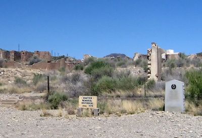
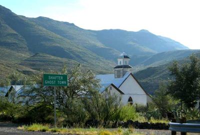
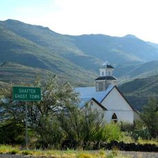
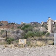
Shafter, Silver mining ghost town in Presidio County, Texas.
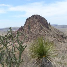
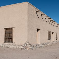
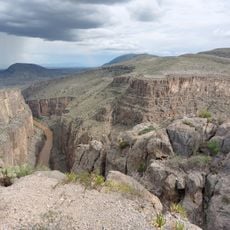
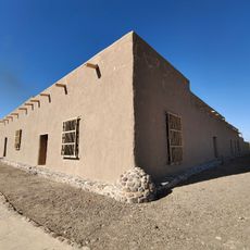
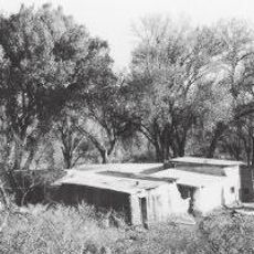
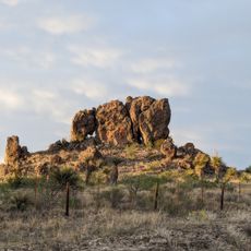
The former mining settlement sits at an elevation of 1,189 meters near Cibolo Creek, surrounded by the Chinati Mountains of West Texas.

John Spencer discovered silver deposits in 1880, leading to the establishment of the Presidio Mining Company and a town named after Colonel William Shafter.

The cemetery contains graves of early settlers and miners who developed the silver mines, producing over 30 million ounces between 1883 and 1940.

The location along U.S. Highway 67 remains accessible, with the silver mine undergoing periodic reopening attempts by different mining corporations.

The town served as a filming location for the 1971 science fiction movie The Andromeda Strain, transforming the abandoned buildings into a fictional village.

Location: Presidio County

Elevation above the sea: 1,189 m

GPS coordinates: 29.82030,-104.30300

Latest update: May 27, 2025 14:03

Hidden places in Texas

Texas contains natural springs, waterfalls, sand dunes and historic sites. The terrain changes from desert to swampland. The state features mining towns, military forts, Japanese gardens and prehistoric locations. Visitors can explore underwater caves, limestone cliffs, and salt marshes. The area includes Native American quarries, Spanish missions, and 19th-century plantations.

Around this place
Show the full map
Prada Marfa
United States of America

Prada Marfa

89.6 km
Cibolo Creek Ranch
United States of America

Cibolo Creek Ranch

5.5 km
Chinati Foundation
United States of America

Chinati Foundation

59.6 km
Cañón de Santa Elena Flora and Fauna Protection Area
Mexico

Cañón de Santa Elena Flora and Fauna Protection Area

89.5 km
Big Bend Ranch State Park
United States of America

Big Bend Ranch State Park

35.3 km
Davis Mountains State Park
United States of America

Davis Mountains State Park

93.8 km
El Paisano Hotel
United States of America

El Paisano Hotel

61.1 km
The Holland Hotel
United States of America

The Holland Hotel

85.9 km
Fort Leaton State Historic Site
United States of America

Fort Leaton State Historic Site

30.8 km
Chihuahuan Desert Nature Center and Botanical Gardens
United States of America

Chihuahuan Desert Nature Center and Botanical Gardens

91.8 km
Presidio County Courthouse
United States of America

Presidio County Courthouse

61.2 km
Peguis Canyon
Mexico

Peguis Canyon

56.8 km
Henry M. and Annie V. Trueheart House
United States of America

Henry M. and Annie V. Trueheart House

93.8 km
Grierson-Sproul House
United States of America

Grierson-Sproul House

93.9 km
Museum of the Big Bend
United States of America

Museum of the Big Bend

87.2 km
Central Marfa Historic District
United States of America

Central Marfa Historic District

61 km
Museum of Electronic Wonders @ FOOD SHARK with Snack Bar & Casita Bar
United States of America

Museum of Electronic Wonders @ FOOD SHARK with Snack Bar & Casita Bar

60.2 km
Fort Leaton State Historic Site
United States of America

Fort Leaton State Historic Site

30.9 km
Marfa Lights Viewing Area
United States of America

Marfa Lights Viewing Area

64.8 km
Granada Theatre
United States of America

Granada Theatre

86.2 km
Rangra Theatres
United States of America

Rangra Theatres

86.1 km
Palace Theater
United States of America

Palace Theater

61.3 km
Brewster County Courthouse
United States of America

Brewster County Courthouse

86 km
Sacred Heart Catholic Mission Church
United States of America

Sacred Heart Catholic Mission Church

475 m
Texas Theater
United States of America

Texas Theater

61.3 km
Starlight Theatre
United States of America

Starlight Theatre

82.3 km
Fortin de la Cienega
United States of America

Fortin de la Cienega

4.2 km
Shafter Historic Mining District
United States of America

Shafter Historic Mining District

848 m
Show the full map

Reviews

Visited this place? Tap the stars to rate it and share your experience / photos with the community! Try now! You can cancel it anytime.

« Shafter - Silver mining ghost town in Presidio County, Texas » is provided by Around Us (aroundus.com). Images and texts are derived from Wikimedia project under a Creative Commons license. You are allowed to copy, distribute, and modify copies of this page, under the conditions set by the license, as long as this note is clearly visible.

Discover hidden gems everywhere you go!

From secret cafés to breathtaking viewpoints, skip the crowded tourist spots and find places that match your style. Our app makes it easy with voice search, smart filtering, route optimization, and insider tips from travelers worldwide. Download now for the complete mobile experience.

Around Us App Screenshot

A unique approach to discovering new places

Le Figaro

All the places worth exploring

France Info

A tailor-made excursion in just a few clicks

20 Minutes