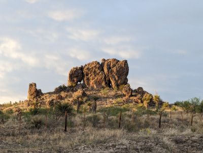
Elephant Rock, rock formation in Presidio County, Texas
Location: Presidio County
Address: Texas, USA
GPS coordinates: 29.87828,-104.27936
Latest update: January 6, 2026 10:55
Cibolo Creek Ranch
5.5 km
Chinati Foundation
52.8 km
Big Bend Ranch State Park
40.6 kmBuilding 98
53 kmFort D. A. Russell
52.4 km
Fort Leaton State Historic Site
37.5 kmChinati Hot Springs
35.5 kmPresidio–Ojinaga International Rail Bridge
37 kmPresidio–Ojinaga International Bridge
37 km
Fort Leaton State Historic Site
37.6 km
Sacred Heart Catholic Mission Church
7.3 kmLa Morita Historic District
11.1 km
Fortin de la Cienega
4.3 kmCañón Navarrete
52.4 kmCañón La Chiva
52.2 kmCañón Oscuro
49.9 kmSt. Joseph Catholic Church
48.1 kmFortin de la Morita
4.3 kmEl Fortin del Cibolo Historic District
5.6 kmCañón Oscuro
40.7 kmEl Fortin del Cibolo
5.3 km
Shafter Historic Mining District
7.7 kmEstatua de Don Quixote
37.3 kmUntitled (dawn to dusk)
52.9 kmPresence of Emptiness
53 kmScenic viewpoint
48.8 kmCapote Falls
46.2 kmVisited this place? Tap the stars to rate it and share your experience / photos with the community! Try now! You can cancel it anytime.
Discover hidden gems everywhere you go!
From secret cafés to breathtaking viewpoints, skip the crowded tourist spots and find places that match your style. Our app makes it easy with voice search, smart filtering, route optimization, and insider tips from travelers worldwide. Download now for the complete mobile experience.
A unique approach to discovering new places❞
— Le Figaro
All the places worth exploring❞
— France Info
A tailor-made excursion in just a few clicks❞
— 20 Minutes