Enable Location

We need your location to show you interesting places around you

Discover nearby places

Find interesting locations and hidden gems around you

Precise directions

Get accurate directions and distances to places

Your location is never shared with other users. It's only used when you tap the location button.

Enchanted Rock

Log in to your account

Start exploring — it's free

Trusted by 62,492 travelers worldwide

Continue with Google
Continue with Apple
or

We will send you a code to connect

By continuing, you accept our Terms and Conditions and our Privacy Policy

Check your inbox

We've sent a pincode in your inbox. Please enter the code below.

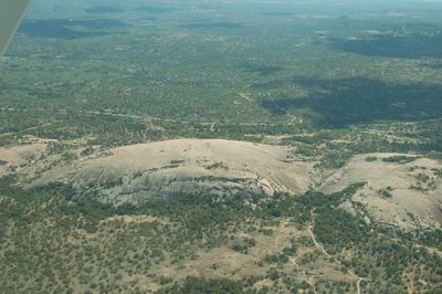
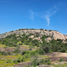
Enchanted Rock, Granite dome in Llano County, US.

Enchanted Rock is a pink granite dome in Llano County that spreads across 640 acres and rises about 425 feet (130 meters) above the Texas hills. The entire formation reaches 1825 feet (556 meters) above sea level and appears as a smooth bulge amid the wooded landscape.

The granite formation emerged 1.1 billion years ago through cooling and crystallization of magma below the Earth's surface. Later erosion processes removed the rock layers above and exposed the dome visible today.

The dome gets its name from the sounds the granite makes when cooling after sunset, which earlier inhabitants found mysterious. Hikers today report a faint creaking and cracking audible on quiet nights, giving the place a distinctive character.

Several trails lead to the summit, with the shortest taking about 45 minutes uphill over exposed, slippery rock. Early morning hours work best to avoid heat and crowds, especially in summer.

Shallow depressions on the surface fill with water after rain and form small pools where transparent shrimp live. These puddles also host rare plants that thrive only in such short-lived water pockets.

The community of curious travelers

AroundUs brings together thousands of curated places, local tips, and hidden gems, enriched daily by 60,000 contributors worldwide.

Start exploring
Location
Elevation above the sea
556 m
Made from material
granite
GPS coordinates
30.50660,-98.81890
Latest update
December 12, 2025 17:40
Hidden places in Texas

Texas combines landscapes that barely resemble each other. The west spreads out in deserts and sand dunes, while the east is marked by swamps and dense forests. Between these extremes lie limestone cliffs, natural springs, and waterfalls that bubble up from the ground. The size of the state allows...

Around this place
Lyndon B. Johnson National Historical Park
United States of America

Lyndon B. Johnson National Historical Park

35 km
National Museum of the Pacific War
United States of America

National Museum of the Pacific War

26.5 km
HA. 19
United States of America

HA. 19

26.5 km
Enchanted Rock State Natural Area
United States of America

Enchanted Rock State Natural Area

292 m
Fort Martin Scott
United States of America

Fort Martin Scott

28.7 km
LBJ Ranch
United States of America

LBJ Ranch

35 km
Fredericksburg Historic District
United States of America

Fredericksburg Historic District

26.2 km
Llano County Courthouse and Jail
United States of America

Llano County Courthouse and Jail

30.3 km
Badu Building
United States of America

Badu Building

31 km
Rheingold School
United States of America

Rheingold School

22 km
State Highway 29 Bridge at the Colorado River
United States of America

State Highway 29 Bridge at the Colorado River

29.6 km
Fredericksburg Memorial Library
United States of America

Fredericksburg Memorial Library

26.3 km
Willow City School
United States of America

Willow City School

16.1 km
Lower South Grape Creek School
United States of America

Lower South Grape Creek School

32.6 km
Wrede School
United States of America

Wrede School

31.7 km
Cherry Spring School
United States of America

Cherry Spring School

13.3 km
Crabapple School
United States of America

Crabapple School

7.3 km
Pecan Creek School
United States of America

Pecan Creek School

25.1 km
Meusebach Creek School
United States of America

Meusebach Creek School

33.6 km
Pacific Combat Zone
United States of America

Pacific Combat Zone

26.6 km
LBJ Ranch House
United States of America

LBJ Ranch House

35 km
Summit Trail
United States of America

Summit Trail

82 m
Arrowhead Creek Vineyard
United States of America

Arrowhead Creek Vineyard

33.5 km
Frank Van Der Stucken Birthplace
United States of America

Frank Van Der Stucken Birthplace

26.3 km
Hoerster Building
United States of America

Hoerster Building

26.4 km
LBJ Statue
United States of America

LBJ Statue

35.1 km
LBJ State Park and Historic Site Visitor Center
United States of America

LBJ State Park and Historic Site Visitor Center

35.2 km
Palace Theatre
United States of America

Palace Theatre

26.3 km
Show the full map
« Enchanted Rock - Granite dome in Llano County, US » is provided by Around Us (aroundus.com). Images and texts are derived from Wikimedia project under a Creative Commons license. You are allowed to copy, distribute, and modify copies of this page, under the conditions set by the license, as long as this note is clearly visible.

Discover hidden gems everywhere you go!

From secret cafés to breathtaking viewpoints, skip the crowded tourist spots and find places that match your style. Our app makes it easy with voice search, smart filtering, route optimization, and insider tips from travelers worldwide. Download now for the complete mobile experience.

Around Us App Screenshot

A unique approach to discovering new places

Le Figaro

All the places worth exploring

France Info

A tailor-made excursion in just a few clicks

20 Minutes

Around Us
Travel Guide & Maps
Download

Send to your phone

QR Code
1

Open the camera app on your mobile.

2

Point at the QR code with your camera. A notification will appear.

3

Tap the notification to open the link.