Enable Location

We need your location to show you interesting places around you

Discover nearby places

Find interesting locations and hidden gems around you

Precise directions

Get accurate directions and distances to places

Your location is never shared with other users. It's only used when you tap the location button.

State Highway 29 Bridge at the Colorado River

Log in to your account

Start exploring — it's free

Trusted by 62,493 travelers worldwide

Continue with Google
Continue with Apple
or

We will send you a code to connect

By continuing, you accept our Terms and Conditions and our Privacy Policy

Check your inbox

We've sent a pincode in your inbox. Please enter the code below.

State Highway 29 Bridge at the Colorado River

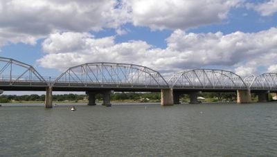
State Highway 29 Bridge at the Colorado River, structure in Buchanan Dam (vicinity), Burnet County, Texas

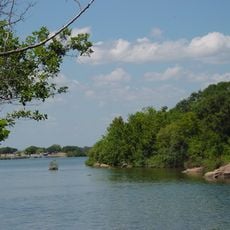
The State Highway 29 Bridge at the Colorado River is a historic structure that crosses the waterway in Burnet County, Texas. It features four truss spans with special tapered piers and a curved steel railing that distinguishes it from other bridges.

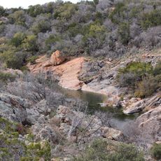
The bridge was constructed between 1936 and 1937 to replace an original road that became flooded when Buchanan Dam was completed. It was built at a natural rocky ledge below the dam where engineers determined the best conditions existed for the bridge approach.

The bridge carries the name of the highway it serves and connects two counties across the river. For local residents, it represents a link between communities and serves as a place where people can experience the region's history while walking.

The crossing is no longer open to vehicle traffic but visitors can explore the structure on foot and enjoy views of the river and surrounding landscape. The location is near Inks Lake, making it a convenient stop during a visit to the area.

The bridge uses a T24-200 truss design from the 1930s that was adopted by only a few other bridges in Texas and is considered the better example of this type. The Austin Bridge Company from Dallas completed the work 45 days ahead of schedule and under the original budget.

The community of curious travelers

AroundUs brings together thousands of curated places, local tips, and hidden gems, enriched daily by 60,000 contributors worldwide.

Start exploring
Location
Location
Address
TX 29 at the Llano Cnty. line
GPS coordinates
30.74810,-98.94830
Latest update
February 9, 2026 11:06
Around this place
Enchanted Rock
United States of America

Enchanted Rock

29.6 km
National Museum of the Pacific War
United States of America

National Museum of the Pacific War

53.6 km
Lake Buchanan
United States of America

Lake Buchanan

50.7 km
HA. 19
United States of America

HA. 19

53.5 km
Inks Lake State Park
United States of America

Inks Lake State Park

55.3 km
Inks Lake
United States of America

Inks Lake

54 km
Antlers Hotel
United States of America

Antlers Hotel

50 km
Fort Mason
United States of America

Fort Mason

28.7 km
Fort Martin Scott
United States of America

Fort Martin Scott

56.4 km
Inks Dam
United States of America

Inks Dam

54 km
Fredericksburg Historic District
United States of America

Fredericksburg Historic District

53.1 km
Llano County Courthouse and Jail
United States of America

Llano County Courthouse and Jail

26 km
Badu Building
United States of America

Badu Building

26.1 km
Mason County Courthouse
United States of America

Mason County Courthouse

27.1 km
Rheingold School
United States of America

Rheingold School

51.4 km
Fredericksburg Memorial Library
United States of America

Fredericksburg Memorial Library

53.1 km
Homesite of John O. Meusebach
United States of America

Homesite of John O. Meusebach

19.1 km
Austin and Northwestern Railroad Historic District-Fairland to Llano
United States of America

Austin and Northwestern Railroad Historic District-Fairland to Llano

49.9 km
Mason Historic District
United States of America

Mason Historic District

26.4 km
Pacific Combat Zone
United States of America

Pacific Combat Zone

53.7 km
Summit Trail
United States of America

Summit Trail

29.7 km
Frank Van Der Stucken Birthplace
United States of America

Frank Van Der Stucken Birthplace

53.2 km
Hoerster Building
United States of America

Hoerster Building

53.4 km
San Saba County Courthouse
United States of America

San Saba County Courthouse

54.5 km
Park Road 4 Historic District
United States of America

Park Road 4 Historic District

54.6 km
Devils Waterhole
United States of America

Devils Waterhole

56.3 km
Palace Theatre
United States of America

Palace Theatre

53.2 km
Acme Dry Goods Building
United States of America

Acme Dry Goods Building

26 km
Show the full map
« State Highway 29 Bridge at the Colorado River - structure in Buchanan Dam (vicinity), Burnet County, Texas » is provided by Around Us (aroundus.com). Images and texts are derived from Wikimedia project under a Creative Commons license. You are allowed to copy, distribute, and modify copies of this page, under the conditions set by the license, as long as this note is clearly visible.

Discover hidden gems everywhere you go!

From secret cafés to breathtaking viewpoints, skip the crowded tourist spots and find places that match your style. Our app makes it easy with voice search, smart filtering, route optimization, and insider tips from travelers worldwide. Download now for the complete mobile experience.

Around Us App Screenshot

A unique approach to discovering new places

Le Figaro

All the places worth exploring

France Info

A tailor-made excursion in just a few clicks

20 Minutes

Around Us
Travel Guide & Maps
Download

Send to your phone

QR Code
1

Open the camera app on your mobile.

2

Point at the QR code with your camera. A notification will appear.

3

Tap the notification to open the link.