Enable Location

We need your location to show you interesting places around you

Discover nearby places

Find interesting locations and hidden gems around you

Precise directions

Get accurate directions and distances to places

Your location is never shared with other users. It's only used when you tap the location button.

Lake Buchanan

Log in to your account

Start exploring — it's free

Trusted by 62,061 travelers worldwide

Continue with Google
Continue with Apple
or

We will send you a code to connect

By continuing, you accept our Terms and Conditions and our Privacy Policy

Check your inbox

We've sent a pincode in your inbox. Please enter the code below.

Lake Buchanan

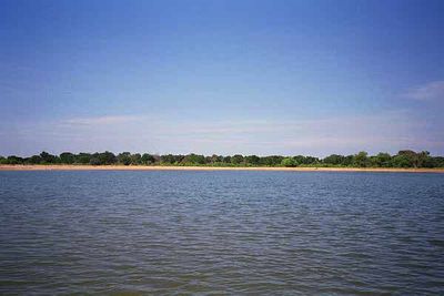
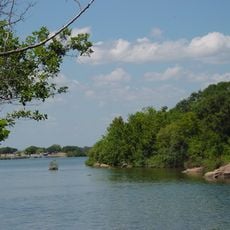
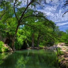
Lake Buchanan, Reservoir in Texas Highland Lakes, United States.

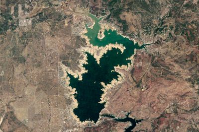
Lake Buchanan is a reservoir in the Texas Highland Lakes of Texas, covering roughly 9,036 hectares of water. The shoreline runs through Burnet and Llano Counties, while the deepest point sits about 40 meters (132 feet) below the surface.

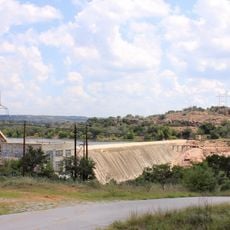
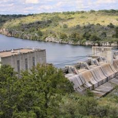
Work on Buchanan Dam began in 1931, halted, then restarted in 1935 before finishing in 1939. The completed structure created the reservoir to supply water to the growing settlements across the region.

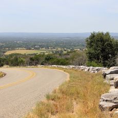
The name honors Texas Congressman James P. Buchanan, who supported the dam project that created this body of water. Today, anglers line the shores while boaters explore its wide expanse, using it for recreation and water sports.

Five concrete ramps provide access to the water, with four on the eastern shore and one on the western shore. Visitors bringing boats will find different launch points and docking areas along the coast.

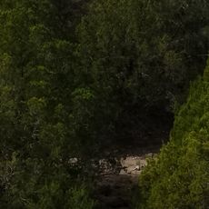
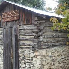
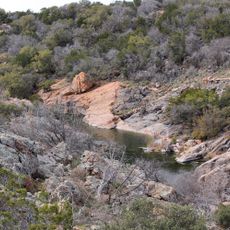
The severe drought of 2011 lowered water levels enough to reveal remnants of the original town of Bluffton. The settlement had been flooded before the dam was built and lay hidden beneath the surface for decades.

The community of curious travelers

AroundUs brings together thousands of curated places, local tips, and hidden gems, enriched daily by 60,000 contributors worldwide.

Start exploring
Location
Elevation above the sea
310 m
Part of
Texas Highland Lakes
GPS coordinates
30.75183,-98.41867
Latest update
December 5, 2025 22:28
Around this place
Enchanted Rock
United States of America

Enchanted Rock

47.1 km
Colorado Bend State Park
United States of America

Colorado Bend State Park

34.4 km
Longhorn Cavern State Park
United States of America

Longhorn Cavern State Park

9.9 km
Balcones Canyonlands National Wildlife Refuge
United States of America

Balcones Canyonlands National Wildlife Refuge

36.5 km
Inks Lake State Park
United States of America

Inks Lake State Park

5.1 km
Inks Lake
United States of America

Inks Lake

4 km
Antlers Hotel
United States of America

Antlers Hotel

10.3 km
Krause Springs
United States of America

Krause Springs

39.9 km
Inks Dam
United States of America

Inks Dam

4 km
Max Starcke Dam
United States of America

Max Starcke Dam

26.7 km
Fort Croghan
United States of America

Fort Croghan

17.3 km
Llano County Courthouse and Jail
United States of America

Llano County Courthouse and Jail

24.7 km
Badu Building
United States of America

Badu Building

24.6 km
Roper Hotel
United States of America

Roper Hotel

24.4 km
Burnet County Courthouse
United States of America

Burnet County Courthouse

18.4 km
Austin and Northwestern Railroad Historic District-Fairland to Llano
United States of America

Austin and Northwestern Railroad Historic District-Fairland to Llano

10.3 km
Pecan Creek School
United States of America

Pecan Creek School

44.6 km
Summit Trail
United States of America

Summit Trail

47.1 km
Longhorn Cavern Administration Building
United States of America

Longhorn Cavern Administration Building

9.9 km
Sulfur Creek Bridge
United States of America

Sulfur Creek Bridge

40.6 km
Lampasas County Courthouse
United States of America

Lampasas County Courthouse

41.8 km
Bertram Depot
United States of America

Bertram Depot

34.8 km
Park Road 4 Historic District
United States of America

Park Road 4 Historic District

6.7 km
Devils Waterhole
United States of America

Devils Waterhole

5.6 km
Uptown Marble Theater
United States of America

Uptown Marble Theater

24.1 km
Gorman Falls
United States of America

Gorman Falls

34.7 km
Lampasas Colored School
United States of America

Lampasas Colored School

42 km
Acme Dry Goods Building
United States of America

Acme Dry Goods Building

24.7 km
Show the full map
« Lake Buchanan - Reservoir in Texas Highland Lakes, United States » is provided by Around Us (aroundus.com). Images and texts are derived from Wikimedia project under a Creative Commons license. You are allowed to copy, distribute, and modify copies of this page, under the conditions set by the license, as long as this note is clearly visible.

Discover hidden gems everywhere you go!

From secret cafés to breathtaking viewpoints, skip the crowded tourist spots and find places that match your style. Our app makes it easy with voice search, smart filtering, route optimization, and insider tips from travelers worldwide. Download now for the complete mobile experience.

Around Us App Screenshot

A unique approach to discovering new places

Le Figaro

All the places worth exploring

France Info

A tailor-made excursion in just a few clicks

20 Minutes

Around Us
Travel Guide & Maps
Download

Send to your phone

QR Code
1

Open the camera app on your mobile.

2

Point at the QR code with your camera. A notification will appear.

3

Tap the notification to open the link.