Gorman Falls

Log in to your account

AroundUs is a community-driven map of interesting places, built by curious explorers like you. It grows with every review, story, and photo you share.
Connect to save your favorite spots, contribute locations, and create personalized routes.
Continue with Google
Continue with Apple
Continue with X
Continue with Facebook
Continue with email
By continuing, you accept our Terms and Conditions and our Privacy Policy
Create an account
Add to collection
Map
Suggest a change
Share

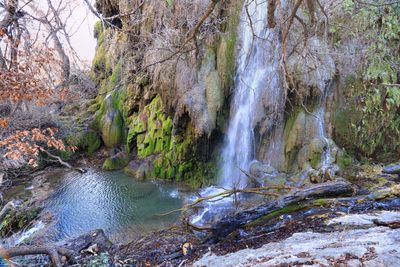
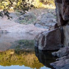
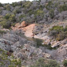
Gorman Falls, 70-foot waterfall in Colorado Bend State Park, Texas.

Gorman Falls is a waterfall located in Colorado Bend State Park that drops about 70 feet and flows year-round from natural springs. The water cascades over limestone layers that have formed over thousands of years, creating layered rock walls on either side.

The waterfall formed over thousands of years as water slowly carved through limestone layers in the Texas Hill Country. The state park was established to protect this natural formation and the surrounding ecosystems from development.

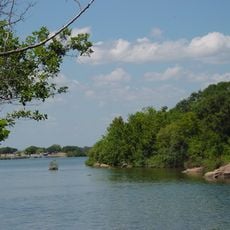
The waterfall draws visitors who come to witness water flowing through limestone, an experience that connects them to the natural cycles of the region. People move through the area with care, respecting the rock formations and the vegetation that depends on the constant moisture.

The trail to the waterfall is a round trip of about 3 miles over rocky ground with steep sections, so sturdy hiking boots are essential. Bring plenty of water and allow two to three hours for the hike if you want time to explore and take photos.

The moist areas around the waterfall support rare moss species and specialized plants that grow only in this location within the region. These delicate organisms cling to the limestone walls and form a miniature ecosystem that depends entirely on the constant spray and moisture.

Location: Colorado Bend State Park

GPS coordinates: 31.05834,-98.48187

Latest update: December 6, 2025 19:08

Photos
Hidden places in Texas

Texas combines landscapes that barely resemble each other. The west spreads out in deserts and sand dunes, while the east is marked by swamps and dense forests. Between these extremes lie limestone cliffs, natural springs, and waterfalls that bubble up from the ground. The size of the state allows...

Around this place
Lake Buchanan
United States of America

Lake Buchanan

34.7 km
Longhorn Cavern State Park
United States of America

Longhorn Cavern State Park

43.4 km
Regency Bridge
United States of America

Regency Bridge

52.3 km
Inks Lake State Park
United States of America

Inks Lake State Park

37.9 km
Inks Lake
United States of America

Inks Lake

37.6 km
Antlers Hotel
United States of America

Antlers Hotel

44.5 km
Inks Dam
United States of America

Inks Dam

37.6 km
Max Starcke Dam
United States of America

Max Starcke Dam

59.9 km
Fort Croghan
United States of America

Fort Croghan

40.9 km
Llano County Courthouse and Jail
United States of America

Llano County Courthouse and Jail

39.1 km
Badu Building
United States of America

Badu Building

38.4 km
Roper Hotel
United States of America

Roper Hotel

57.7 km
Burnet County Courthouse
United States of America

Burnet County Courthouse

41.5 km
State Highway 29 Bridge at the Colorado River
United States of America

State Highway 29 Bridge at the Colorado River

56.4 km
Austin and Northwestern Railroad Historic District-Fairland to Llano
United States of America

Austin and Northwestern Railroad Historic District-Fairland to Llano

44.5 km
US 190 Bridge at the Colorado River
United States of America

US 190 Bridge at the Colorado River

19.4 km
Mills County Courthouse
United States of America

Mills County Courthouse

45.1 km
Longhorn Cavern Administration Building
United States of America

Longhorn Cavern Administration Building

43.4 km
Sulfur Creek Bridge
United States of America

Sulfur Creek Bridge

28.6 km
San Saba County Courthouse
United States of America

San Saba County Courthouse

27.1 km
Lampasas County Courthouse
United States of America

Lampasas County Courthouse

29 km
Bertram Depot
United States of America

Bertram Depot

53.7 km
Park Road 4 Historic District
United States of America

Park Road 4 Historic District

41 km
Devils Waterhole
United States of America

Devils Waterhole

36.5 km
Uptown Marble Theater
United States of America

Uptown Marble Theater

57.6 km
Lampasas Colored School
United States of America

Lampasas Colored School

29.5 km
Acme Dry Goods Building
United States of America

Acme Dry Goods Building

39 km
Briggs State Bank
United States of America

Briggs State Bank

56.4 km
Show the full map
Reviews

Visited this place? Tap the stars to rate it and share your experience / photos with the community! Try now! You can cancel it anytime.

« Gorman Falls - 70-foot waterfall in Colorado Bend State Park, Texas » is provided by Around Us (aroundus.com). Images and texts are derived from Wikimedia project under a Creative Commons license. You are allowed to copy, distribute, and modify copies of this page, under the conditions set by the license, as long as this note is clearly visible.

Discover hidden gems everywhere you go!

From secret cafés to breathtaking viewpoints, skip the crowded tourist spots and find places that match your style. Our app makes it easy with voice search, smart filtering, route optimization, and insider tips from travelers worldwide. Download now for the complete mobile experience.

Around Us App Screenshot

A unique approach to discovering new places

Le Figaro

All the places worth exploring

France Info

A tailor-made excursion in just a few clicks

20 Minutes