Enable Location

We need your location to show you interesting places around you

Discover nearby places

Find interesting locations and hidden gems around you

Precise directions

Get accurate directions and distances to places

Your location is never shared with other users. It's only used when you tap the location button.

Regency Bridge

Log in to your account

Start exploring — it's free

Trusted by 62,061 travelers worldwide

Continue with Google
Continue with Apple
or

We will send you a code to connect

By continuing, you accept our Terms and Conditions and our Privacy Policy

Check your inbox

We've sent a pincode in your inbox. Please enter the code below.

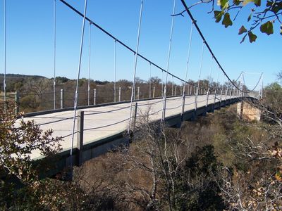
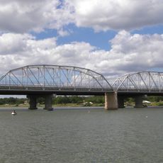
Regency Bridge, Suspension bridge in Regency, Texas, United States

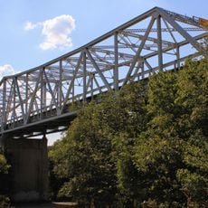
Regency Bridge is a suspension bridge crossing the Colorado River between Mills and San Saba counties in Texas. The wooden deck spans about 105 meters and measures roughly 16 feet wide for vehicle passage.

The bridge was built in 1939 to replace two earlier structures that failed: one collapsed under cattle weight in 1903 and another was destroyed by floods in 1936. This new construction restored reliable transportation across the river between the counties.

The bridge served as a gathering spot for neighbors in the 1940s, who organized picnics and dances near the river. These gatherings shaped the social life of this rural community.

The bridge remains open to vehicle traffic and handles one lane of crossing at a time. Visitors should be prepared for the aged structure and conditions that vary with weather and water flow.

This bridge is among the last of its kind in Texas still open to automobile traffic and is recognized as a historic structure. The design represents engineering solutions from an earlier era of rural development.

The community of curious travelers

AroundUs brings together thousands of curated places, local tips, and hidden gems, enriched daily by 60,000 contributors worldwide.

Start exploring
Location
Location
Inception
1939
Address
0.75 mi. S of Regency at Colorado River
GPS coordinates
31.41050,-98.84631
Latest update
December 7, 2025 20:42
Around this place
Lake Buchanan
United States of America

Lake Buchanan

83.9 km
Colorado Bend State Park
United States of America

Colorado Bend State Park

52.1 km
Fort Mason
United States of America

Fort Mason

83.9 km
Proctor Lake
United States of America

Proctor Lake

72.8 km
Lake Brownwood State Park
United States of America

Lake Brownwood State Park

52.6 km
Llano County Courthouse and Jail
United States of America

Llano County Courthouse and Jail

75.3 km
Badu Building
United States of America

Badu Building

74.6 km
United States of America

R. F. Hardin High School

37.6 km
Mason County Courthouse
United States of America

Mason County Courthouse

82.4 km
McCulloch County Courthouse
United States of America

McCulloch County Courthouse

54.7 km
State Highway 29 Bridge at the Colorado River
United States of America

State Highway 29 Bridge at the Colorado River

74.4 km
Old McCulloch County Jail
United States of America

Old McCulloch County Jail

55.8 km
Camp Colorado Replica
United States of America

Camp Colorado Replica

73.4 km
Mason Historic District
United States of America

Mason Historic District

82 km
St. John's Episcopal Church
United States of America

St. John's Episcopal Church

37 km
US 190 Bridge at the Colorado River
United States of America

US 190 Bridge at the Colorado River

34.4 km
Hamilton County Courthouse
United States of America

Hamilton County Courthouse

76 km
Mills County Courthouse
United States of America

Mills County Courthouse

26.2 km
Sulfur Creek Bridge
United States of America

Sulfur Creek Bridge

74.6 km
Lampasas County Courthouse
United States of America

Lampasas County Courthouse

74.3 km
San Saba County Courthouse
United States of America

San Saba County Courthouse

26.9 km
Brown County Museum of History
United States of America

Brown County Museum of History

37.1 km
Lampasas Colored School
United States of America

Lampasas Colored School

74.7 km
Comanche County Courthouse
United States of America

Comanche County Courthouse

58.8 km
Robert E. Howard House
United States of America

Robert E. Howard House

84.9 km
Gorman Falls
United States of America

Gorman Falls

52.3 km
Group Recreation Hall
United States of America

Group Recreation Hall

52.5 km
Acme Dry Goods Building
United States of America

Acme Dry Goods Building

75.3 km
Show the full map
« Regency Bridge - Suspension bridge in Regency, Texas, United States » is provided by Around Us (aroundus.com). Images and texts are derived from Wikimedia project under a Creative Commons license. You are allowed to copy, distribute, and modify copies of this page, under the conditions set by the license, as long as this note is clearly visible.

Discover hidden gems everywhere you go!

From secret cafés to breathtaking viewpoints, skip the crowded tourist spots and find places that match your style. Our app makes it easy with voice search, smart filtering, route optimization, and insider tips from travelers worldwide. Download now for the complete mobile experience.

Around Us App Screenshot

A unique approach to discovering new places

Le Figaro

All the places worth exploring

France Info

A tailor-made excursion in just a few clicks

20 Minutes

Around Us
Travel Guide & Maps
Download

Send to your phone

QR Code
1

Open the camera app on your mobile.

2

Point at the QR code with your camera. A notification will appear.

3

Tap the notification to open the link.