Palo Duro Canyon

Log in to your account

AroundUs is a community-driven map of interesting places, built by curious explorers like you. It grows with every review, story, and photo you share.
Connect to save your favorite spots, contribute locations, and create personalized routes.
By continuing, you accept our Terms and Conditions and our Privacy Policy

Palo Duro Canyon

Add to collection
Map
Suggest a change
Share

Palo Duro Canyon, Canyon system in Armstrong County, United States.

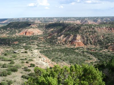
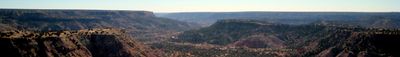
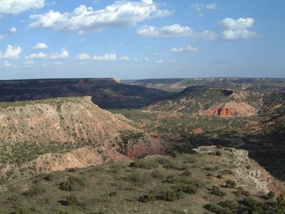
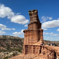
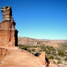
Palo Duro Canyon is a gorge in the Texas Panhandle that extends for 40 miles and cuts down as deep as 1,000 feet (300 meters) in some spots. The formation displays alternating layers of red and ochre rock that can be traced during walks through gentle hills and narrow valleys.

A military campaign in 1874 led by Colonel Ranald Mackenzie resulted in the removal of tribes from this area and opened the way for ranching. Charles Goodnight established the JA Ranch on the slopes a few years later and used the grasslands for large herds.

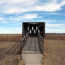
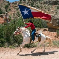
The performance at Pioneer Amphitheatre carries the title TEXAS and links music with regional stories about life on the Plains. The show ends with fireworks that illuminate the rock faces in different colors.

More than 30 miles of trails pass through flat and steep sections and suit walkers and cyclists. Overnight stays are possible at basic tent sites or equipped lodgings.

The Prairie Dog Town Fork Red River flows through the valley and continuously exposes rock layers from the Permian and Triassic periods. These visible sediments reach back more than 240 million years and document geological changes across the region.

Location: Armstrong County

Location: Briscoe County

Location: Hall County

Location: Randall County

GPS coordinates: 34.95000,-101.66700

Latest update: December 4, 2025 23:03

Hidden places in Texas

Texas contains natural springs, waterfalls, sand dunes and historic sites. The terrain changes from desert to swampland. The state features mining towns, military forts, Japanese gardens and prehistoric locations. Visitors can explore underwater caves, limestone cliffs, and salt marshes. The area includes Native American quarries, Spanish missions, and 19th-century plantations.

Around this place
Show the full map
Cadillac Ranch
United States of America

Cadillac Ranch

39.3 km
Don Harrington Discovery Center
United States of America

Don Harrington Discovery Center

35.7 km
Amarillo Civic Center
United States of America

Amarillo Civic Center

32.5 km
Atchison, Topeka and Santa Fe Railway 5000
United States of America

Atchison, Topeka and Santa Fe Railway 5000

32.7 km
Wonderland Park
United States of America

Wonderland Park

35.7 km
Buffalo Lake National Wildlife Refuge
United States of America

Buffalo Lake National Wildlife Refuge

42 km
Chase Tower
United States of America

Chase Tower

32.7 km
Santa Fe Building
United States of America

Santa Fe Building

32.3 km
Panhandle–Plains Historical Museum
United States of America

Panhandle–Plains Historical Museum

23.1 km
Mayan Mindbender
United States of America

Mayan Mindbender

36.1 km
Amarillo National Bank Sox Stadium
United States of America

Amarillo National Bank Sox Stadium

31 km
Texas Air & Space Museum
United States of America

Texas Air & Space Museum

29.8 km
Texas Tornado
United States of America

Texas Tornado

36 km
Amarillo Museum of Art
United States of America

Amarillo Museum of Art

31.2 km
Charles and Mary Ann (Molly) Goodnight Ranch House
United States of America

Charles and Mary Ann (Molly) Goodnight Ranch House

45 km
Amarillo Zoo
United States of America

Amarillo Zoo

35.7 km
Potter County Courthouse
United States of America

Potter County Courthouse

32.6 km
Sacred Heart Cathedral
United States of America

Sacred Heart Cathedral

32.3 km
J. Marvin Jones Federal Building and United States Courthouse
United States of America

J. Marvin Jones Federal Building and United States Courthouse

32.6 km
Maxwell's Pumpkin Farm
United States of America

Maxwell's Pumpkin Farm

25.9 km
Sports World
United States of America

Sports World

28.8 km
Courtyard by Marriott, Downtown Amarillo
United States of America

Courtyard by Marriott, Downtown Amarillo

32.4 km
Palo Duro State Park
United States of America

Palo Duro State Park

1.9 km
Llano Cemetery
United States of America

Llano Cemetery

29.7 km
Lighthouse Peak
United States of America

Lighthouse Peak

3.1 km
Randall County Courthouse
United States of America

Randall County Courthouse

24 km
Amarillo Natatorium
United States of America

Amarillo Natatorium

34.3 km
Texas Outdoor Musical
United States of America

Texas Outdoor Musical

3.1 km
Show the full map

Reviews

Visited this place? Tap the stars to rate it and share your experience / photos with the community! Try now! You can cancel it anytime.

« Palo Duro Canyon - Canyon system in Armstrong County, United States » is provided by Around Us (aroundus.com). Images and texts are derived from Wikimedia project under a Creative Commons license. You are allowed to copy, distribute, and modify copies of this page, under the conditions set by the license, as long as this note is clearly visible.

Discover hidden gems everywhere you go!

From secret cafés to breathtaking viewpoints, skip the crowded tourist spots and find places that match your style. Our app makes it easy with voice search, smart filtering, route optimization, and insider tips from travelers worldwide. Download now for the complete mobile experience.

Around Us App Screenshot

A unique approach to discovering new places

Le Figaro

All the places worth exploring

France Info

A tailor-made excursion in just a few clicks

20 Minutes