See the monuments around you in AROpen chests in the app
Around Us is built for your phone — point your camera at the streets and discover the monuments and places around you in augmented reality.Around Us is built for your phone — chests unlock when you walk, explore and capture nearby places.
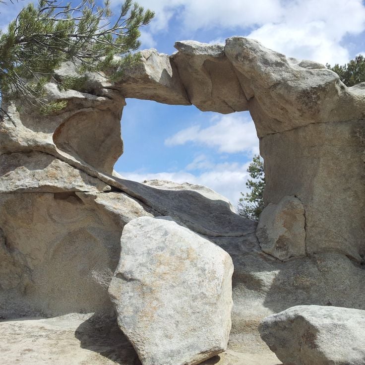
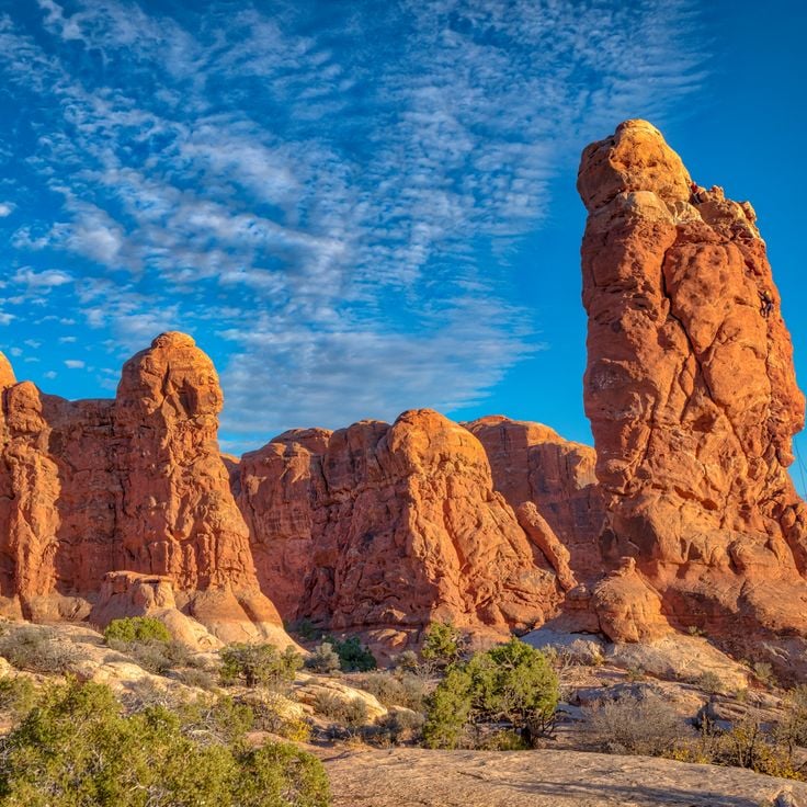
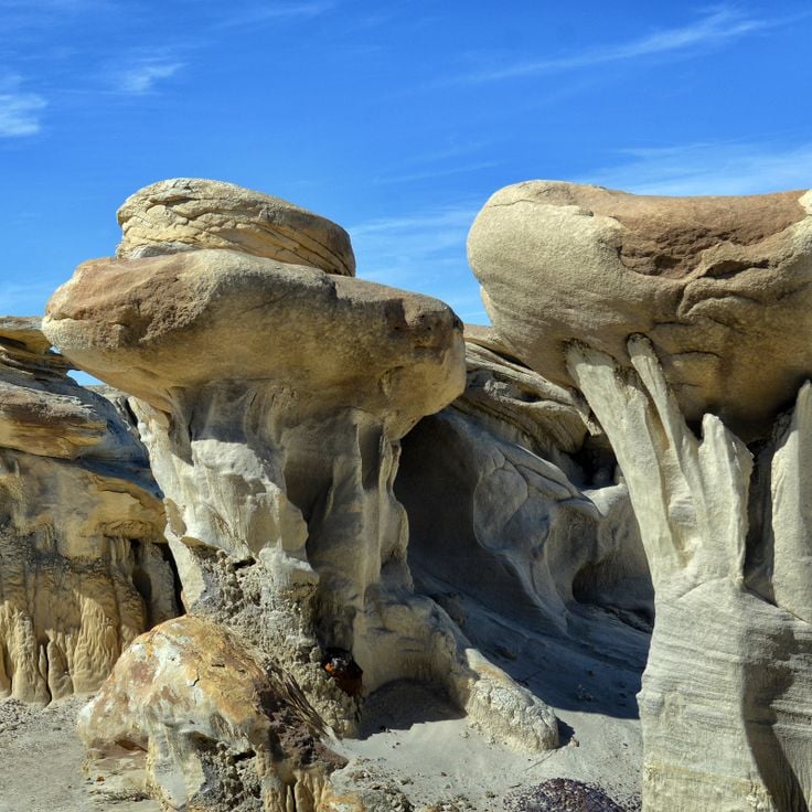
Rock pillars and spires shaped by erosion stand as natural monuments across various locations worldwide. These geological structures, known as hoodoos, display different colors and shapes based on their mineral composition and environmental conditions. From the red rocks of Utah to the limestone formations of Turkey, these sites present geological formations created over millions of years through wind and water erosion.
These formations develop through differential erosion, where softer rock layers erode faster than harder layers, leaving slender columns often capped with protective harder rock. Visitors find such structures in desert landscapes, canyons, and plateaus where conditions favor their formation and preservation. The color palette ranges from white to orange, red, and gray, depending on the minerals present such as iron oxide, limestone, or clay.
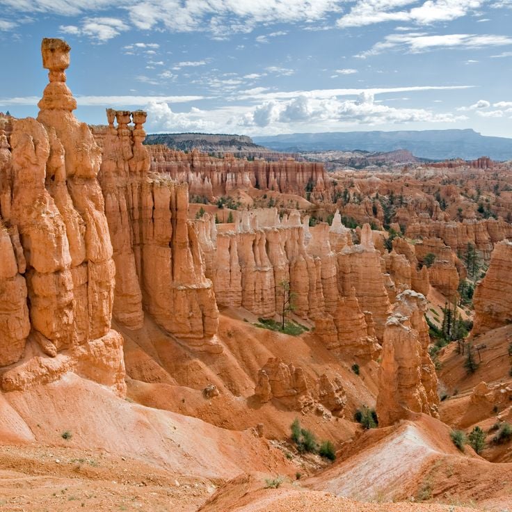
Bryce Canyon National Park sits on the Colorado Plateau at elevations between 2,400 and 2,700 meters. The park's distinctive rock towers, called hoodoos, formed through frost weathering and water erosion of red limestone layers. The amphitheater extends several kilometers and displays varying rock colors from orange to red to white. Multiple hiking trails wind between the formations and provide different perspectives on the geological structures.
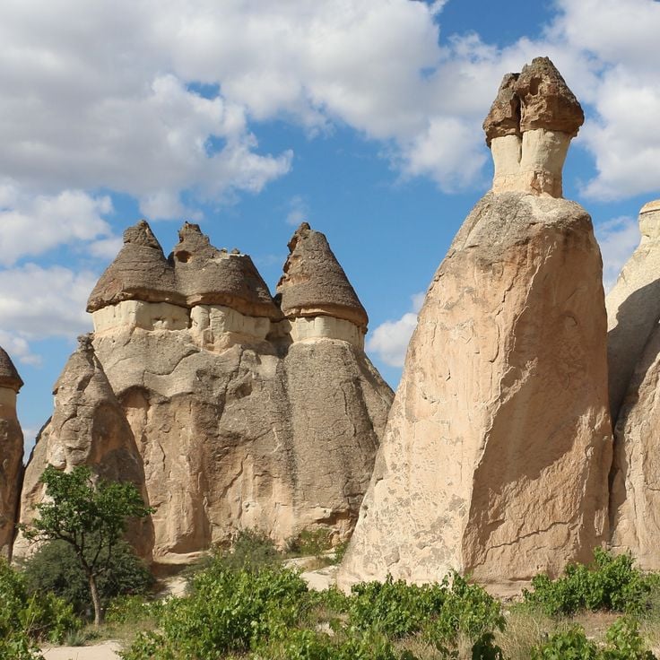
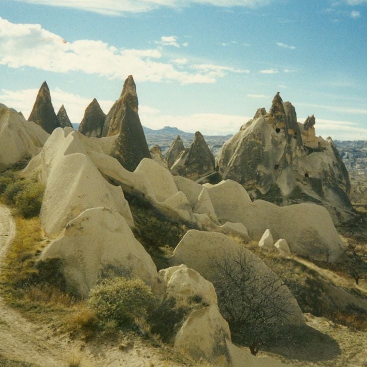
The Fairy Chimneys of Cappadocia are tall rock formations created by the erosion of volcanic ash deposits. Harder rock caps protect the softer rock beneath, forming distinctive cone shapes. These geological structures define the region's landscape and attract photographers from around the world. The formations vary in height and shape, with some reaching several meters tall.
Göreme National Park is located in Cappadocia and displays rock formations of tuff stone created by volcanic activity and erosion. The area contains cave dwellings, Byzantine churches with frescoes dating from the 10th to 12th centuries, and underground cities. The characteristic fairy chimneys and rock cones form a landscape that has been inhabited since Roman times.
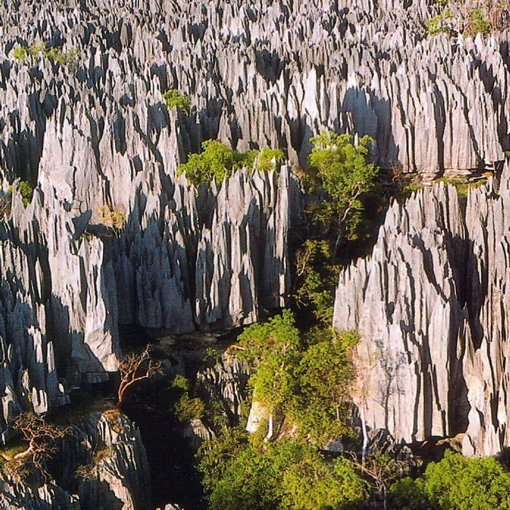
Tsingy de Bemaraha National Park protects an extensive landscape of limestone needles formed through centuries of erosion. The grey rock formations rise up to 70 meters high, creating an impenetrable labyrinth of sharp pinnacles. Deep gorges and caves run between the rocks, where adapted flora and fauna have developed. The area encompasses dry deciduous forests and several rivers that wind through the limestone formation.
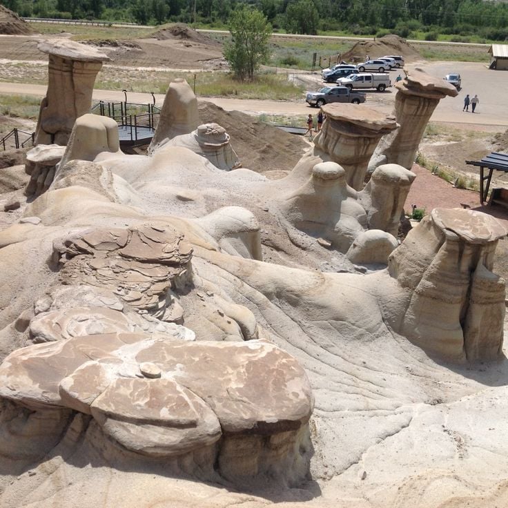
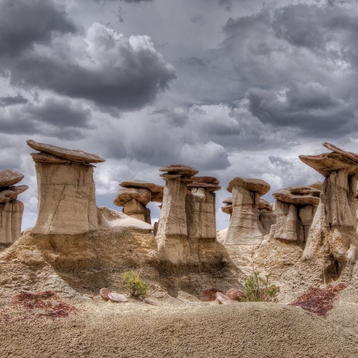
The Drumheller Hoodoos are geological formations of sandstone and mudstone rising from the Red Deer River Valley. These stone columns formed through millennia of erosion, where softer rock layers beneath harder cap rocks were worn away by wind and water. Located approximately ten kilometers east of Drumheller, the hoodoos provide direct access via a paved pathway with viewing platforms for photographers.
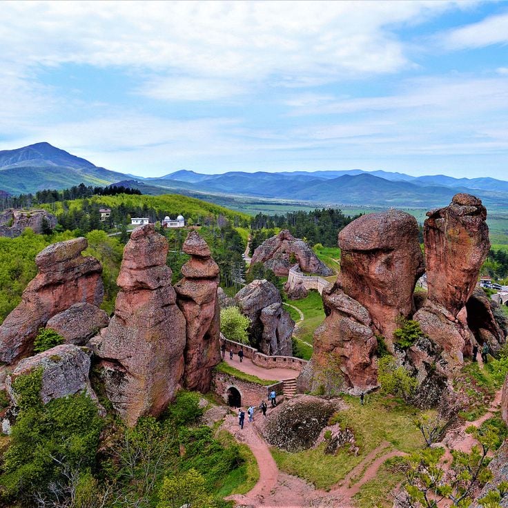
The Belogradchik Rocks are composed of red sandstone and limestone formations shaped by tectonic movements, erosion, and weathering over 230 million years. These geological structures rise up to 200 meters in height and span approximately 90 square kilometers in northwestern Bulgaria. The various rock groups bear local names based on their distinctive shapes created by natural processes.
The Ah-Shi-Sle-Pah Wilderness Study Area covers 6,563 acres of public land in northwestern New Mexico. This remote desert terrain displays heavily eroded Cretaceous sediment layers forming unusual rock formations, slender hoodoos, and grey clay hills. Fossil beds and petrified wood lie scattered throughout the barren landscape. The isolated location requires four-wheel drive vehicles to access, with no paved roads leading into the area.
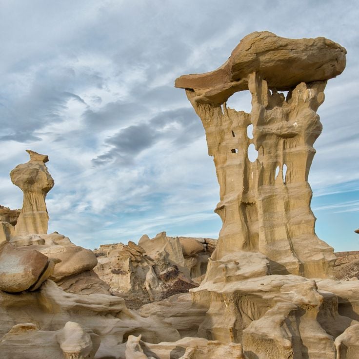
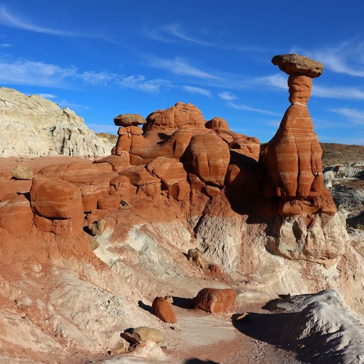
The Kasha-Katuwe Tent Rocks rise from the New Mexico desert as distinctive cone-shaped geological formations. These structures formed from volcanic deposits laid down 6 to 7 million years ago during eruptions from the Jemez volcanic field. Harder stone caps protect the softer pumice and tuff layers beneath from erosion, creating the tent-like shapes. A trail winds through the canyon between formations reaching up to 90 feet in height, exposing bands of volcanic ash, pumice, and rock fragments in varied colors from white to pink.
Chiricahua National Monument protects a volcanic area containing thousands of stone columns created by millions of years of erosion. The rock formations consist of layered rhyolite tuff and form structures resembling towers, columns, and balanced rocks. The site spans the Chiricahua Mountains and provides hiking trails through the geological formations. Apache tribes called this region the Land of Standing Rocks.
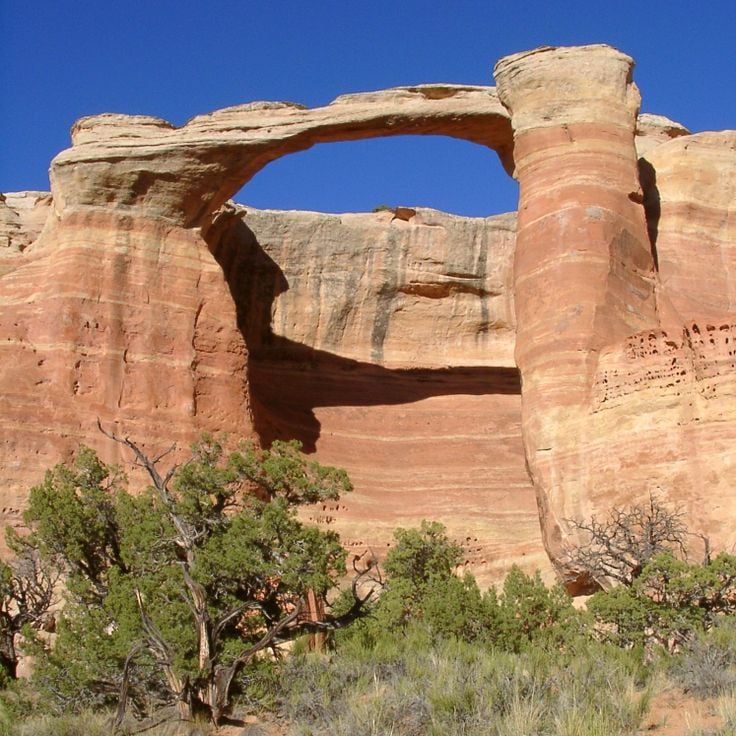
Devil's Garden sits within the Grand Staircase-Escalante National Monument and presents a collection of sandstone formations created through erosion processes. The geological structures include arches, towers, and rock spires in various shapes and sizes. The area spans several hectares and offers trails that wind between the formations. The red and orange sandstone rocks create contrasts against the desert sky and surrounding vegetation.
The Valley of Dreams consists of weathered sandstone pillars and geological formations shaped by wind and water erosion. The rock structures rise from the desert landscape and form natural sculptures in various shapes. This remote area in New Mexico displays layers of sedimentary rock in different shades of red and orange.
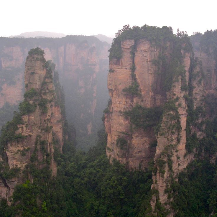
Zhangjiajie National Forest Park spans 480 square kilometers and features more than 3000 sandstone pillars rising from subtropical forest. These geological formations developed through erosion over millions of years, with some columns reaching heights of 300 meters. The park served as inspiration for the floating mountains in the film Avatar and includes several viewing platforms where visitors can photograph the rock formations. A glass-bottomed walkway connects some of the highest peaks, offering views into the valleys below.
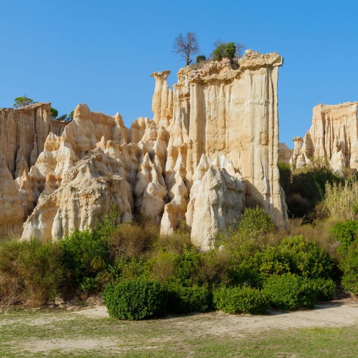
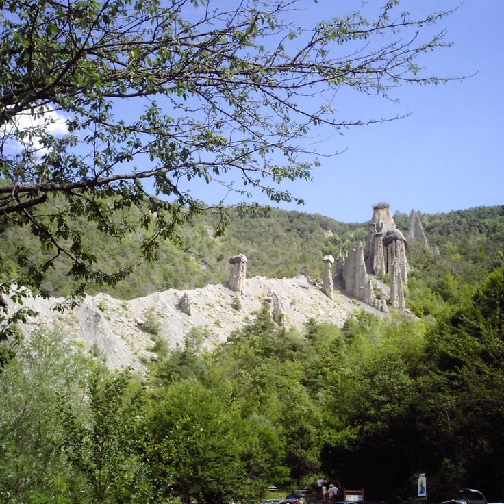
Les Orgues d'Ille-sur-Têt is a geological site featuring rock formations sculpted by erosion. These vertical structures of sand and clay have been shaped over thousands of years by wind and water. The rocks form columns and walls resembling organ pipes, arranged in a natural amphitheater setting.
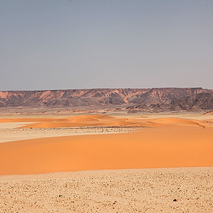
Gilf Kebir National Park spreads across a desert plateau in southwestern Egypt. Large chalk rock formations rise from the sandy plains, creating distinctive structures formed by millions of years of wind erosion. The area sits in one of the driest regions of the Sahara and displays geological layers from different epochs. The rock formations serve as photographic subjects and attract visitors who explore the remote desert terrain.
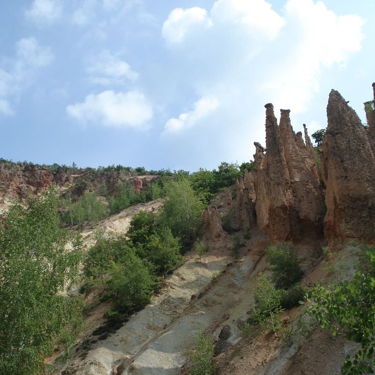
Davolja Varos presents over two hundred natural stone pillars formed through continuous erosion of volcanic tuff. These geological formations reach heights of up to fifteen meters and bear andesite blocks as protective caps. The area contains two acidic springs with high mineral content. The pyramid structures form as rainwater erodes softer material while exposing harder rock masses. This process continuously shapes the landscape, creating new pillars while older ones erode.
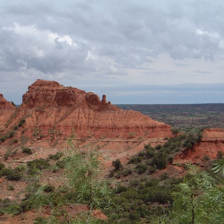
Caprock Canyons State Park spans 6,000 hectares in northern Texas and displays sandstone formations in shades of red and ochre. Erosion has carved deep canyons and distinct rock structures suitable for photography. The park preserves a section of the Palo Duro Canyon formation and provides hiking trails that traverse different geological layers. Visitors can photograph the natural rock formations from various perspectives.
The Toadstool Rock Formations feature red sandstone pedestals topped with balanced caprock boulders. These geological structures formed through differential erosion of rock layers over millions of years. A 1.5-mile hiking trail traverses the area within Grand Staircase-Escalante National Monument, providing access to multiple mushroom-shaped formations that rise from the surrounding badlands terrain.
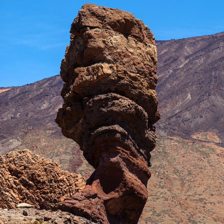
Roque Cinchado is a 27-meter tall volcanic rock formation located in Teide National Park. This erosion-formed structure displays distinct layers of basalt and pumice stone. The rock stands on a narrow base and offers direct views of Mount Teide volcano, which rises to 3,718 meters as Spain's highest peak. The formation sits within the Las Cañadas mountain landscape at approximately 2,100 meters elevation.
The rock formations at Writing-on-Stone rise along the Milk River Valley and present more than 50 documented rock art sites created by the Blackfoot people. The sandstone cliffs display both carved petroglyphs and painted pictographs in mineral pigments, documenting different periods of Indigenous history. These archaeological records exist among weathered hoodoos and rock faces shaped by thousands of years of erosion.
The Abu Simbel Temples were carved into rock cliffs in the 13th century BCE and rise from the western shore of Lake Nasser. The larger temple displays four seated colossal statues of Ramesses II on its facade, each approximately 20 meters tall. The smaller temple is dedicated to Queen Nefertari and the goddess Hathor. These structures were relocated 65 meters higher in the 1960s to protect them from the rising waters created by the Aswan High Dam.
The Al Naslaa Rock Formation stands in the desert near Tayma and comprises two massive sandstone blocks separated by a perfectly straight vertical gap. The boulders rest on small pedestals and each weighs several tons. The precise split appears man-made but resulted from natural geological processes over thousands of years. Petroglyphs on the surface indicate that humans have known this formation since ancient times. The reddish-brown rocks contrast sharply with the pale desert sand and attract geologists and photographers alike.
The Demoiselles Coiffées de Pontis are geological formations consisting of rock columns topped with flat stone slabs. Erosion over millions of years shaped these structures that resemble figures wearing hats. The differential weathering of rock layers created these natural pillars in the Sasse valley.
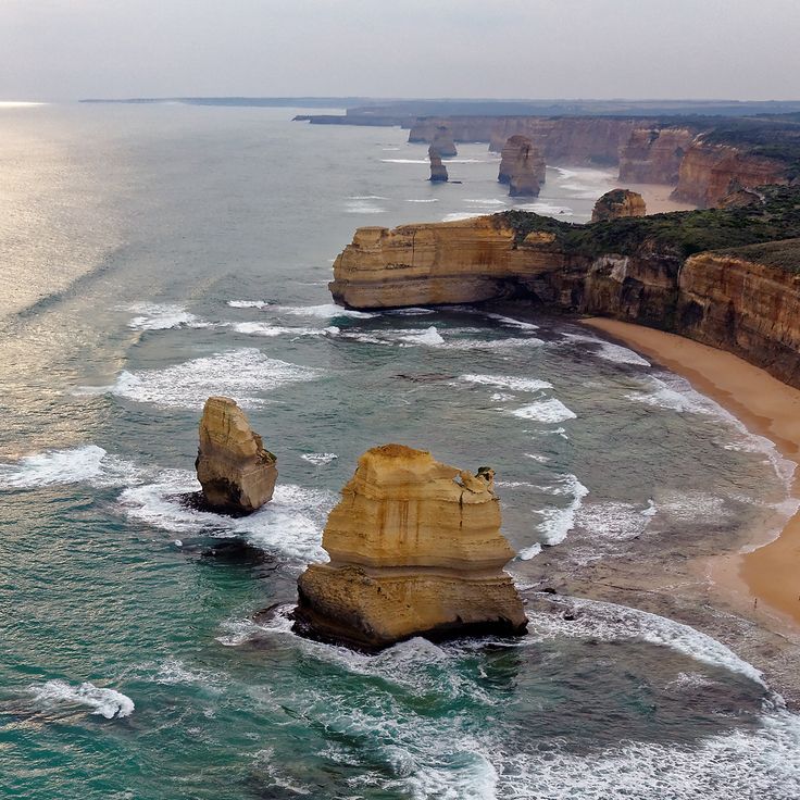
The limestone pillars of the Twelve Apostles rise from the Southern Ocean along Victoria's Great Ocean Road. These geological formations developed through thousands of years of erosion by ocean waves and wind that shaped the soft limestone cliffs of the coastline. The remaining stacks stand in shallow water near the shore and provide views of natural coastal erosion processes.
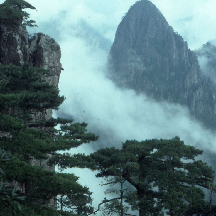
Huángshān rises in Anhui Province and presents a series of granite peaks that frequently tower above the clouds. Weathering shaped these characteristic rock formations over millions of years. Narrow summits emerge from the mist and form distinct silhouettes. Pine trees grow directly from rock crevices and withstand the extreme conditions at this elevation. Geological processes created sharp contours and steep precipices that define the landscape.
The Garden of Eden in Arches National Park presents distinctive sandstone formations created through millions of years of natural erosion. This geological area displays freestanding columns and towers of red sandstone shaped by wind and water. The viewpoint provides direct access to these rock structures and allows photography of the characteristic stone architecture. The formation sits along the Park Avenue section and is accessible from the park's main road.
The Bisti Wilderness is a geological area in the New Mexico desert known for its unusual stone formations. These rounded structures were created through differential erosion of sandstone and shale layers over millions of years. The formations resemble large eggs and provide photographers with interesting subjects. This area lies away from main roads and requires hiking through open terrain.
Rattlesnake Arches sit within a remote section of the McInnis Canyons and provide access to more than 30 natural stone arches formed through millennia of erosion. The sandstone formations display various shades of red and orange, creating photographic subjects against the sky. Hiking trails lead through the terrain to multiple arches of varying sizes, with some formations spanning over 15 meters. The area lies far from paved roads and requires four-wheel-drive vehicles for access as well as adequate water supplies.
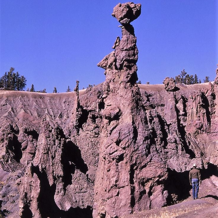
Hoodoo Basin in the northern section of Yellowstone National Park presents a geological depression filled with numerous stone pillars. These formations developed through the erosion of volcanic rock over thousands of years. The rock spires rise at varying heights from the basin floor, creating a maze of weathered volcanic stone. Access involves hiking trails through forested terrain, with the stone formations providing photogenic subjects under different lighting conditions.
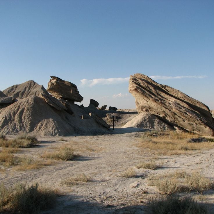
The Geologic Park of Nebraska presents rock formations made of sandstone and clay, sculpted by erosion over the past 23 million years. The towers, pillars and rock walls extend across the grassland of the High Plains near Harrison. Visitors can walk among the geological structures and observe the different layers ranging from prehistoric marine deposits to volcanic ash.
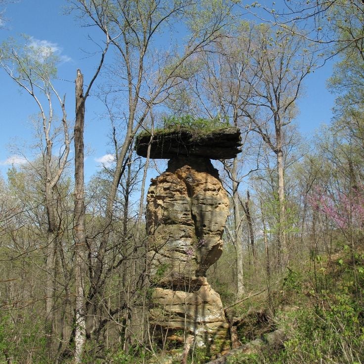
This natural sandstone formation in Shoals rises 40 feet above the surrounding terrain and displays a distinctive shape with a narrow neck and wide base, resembling a water jug. Erosion has carved this geological structure from the bedrock over thousands of years. The monument sits within the forested region of Martin County and can be reached via a short hiking trail. The formation serves as an example of the geological processes that have shaped southern Indiana.
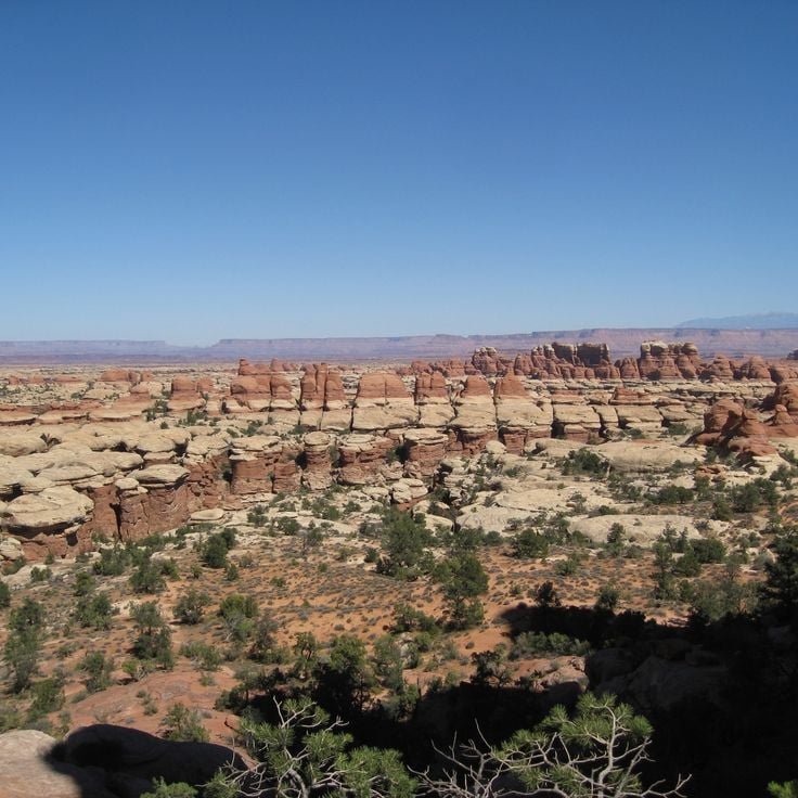
The rock formations of Canyonlands consist of red sandstone spires that extend across the desert landscape in the southeastern section of the park. These natural structures form extensive fields of rock columns and hoodoos, shaped by thousands of years of erosion. The area provides numerous vantage points for photographing the geometric patterns and the characteristic red-brown coloring of the sandstone.
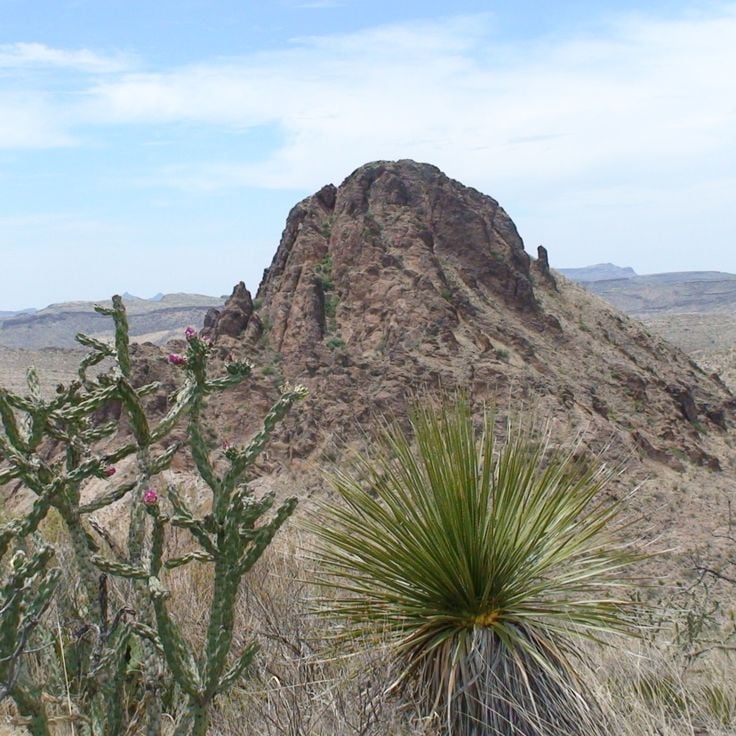
This desert park in West Texas features numerous rock formations created by volcanic activity millions of years ago. The area sits within the Chihuahuan Desert and displays geological structures formed from solidified lava and tuff rock. The landscape consists of hoodoos, towers, and columns shaped by erosion over time. Visitors can access hiking trails to explore the various formations and observe the desert flora of the region.
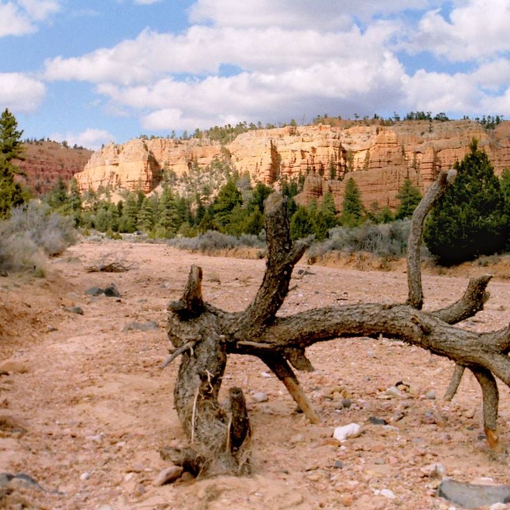
Red Canyon presents rock formations in shades of orange and crimson that rise along sandstone cliffs. These geological structures are located just 5 kilometers from Bryce Canyon National Park and display similar erosion patterns with slender rock spires and layered sediment formations. The canyon sits along Scenic Byway 12 and serves as a gateway to the larger national park.
Coal Mine Canyon sits within the Navajo Reservation south of Tuba City, displaying eroded sandstone formations in shades of white, orange and purple. These geological structures, shaped by millions of years of erosion, rise from the desert floor as slender columns and towers. The unpaved access road leads to the canyon rim, where views reveal the colorful rock layers. This site receives considerably fewer visitors than other canyons in the region.
Hell's Half Acre spans 2000 acres of volcanic terrain formed by prehistoric lava flows from the Great Rift volcanic system. This basalt field displays dark spires, natural stone arches, and hardened lava formations rising from the Snake River Plain. The site provides numerous compositions for photography, with its network of black rock towers and eroded volcanic structures creating a varied landscape.
The City of Rocks National Reserve contains granite spires and monoliths that rise over 60 meters above the ground, formed through millions of years of erosion. This reserve spans 57 square kilometers in southern Idaho and displays numerous geological formations composed of Almo Pluton granite, which solidified approximately 28 million years ago. The distinctive rock structures served as a landmark for pioneers traveling the California Trail during the 19th century. Today, the area attracts climbers, hikers, and photographers who document the unusual stone formations and expansive views across the high desert landscape.
Bryce Canyon National Park sits on the Colorado Plateau at elevations between 2,400 and 2,700 meters. The park's distinctive rock towers, called hoodoos, formed through frost weathering and water erosion of red limestone layers. The amphitheater extends several kilometers and displays varying rock colors from orange to red to white. Multiple hiking trails wind between the formations and provide different perspectives on the geological structures.
The Fairy Chimneys of Cappadocia are tall rock formations created by the erosion of volcanic ash deposits. Harder rock caps protect the softer rock beneath, forming distinctive cone shapes. These geological structures define the region's landscape and attract photographers from around the world. The formations vary in height and shape, with some reaching several meters tall.
Göreme National Park is located in Cappadocia and displays rock formations of tuff stone created by volcanic activity and erosion. The area contains cave dwellings, Byzantine churches with frescoes dating from the 10th to 12th centuries, and underground cities. The characteristic fairy chimneys and rock cones form a landscape that has been inhabited since Roman times.
Tsingy de Bemaraha National Park protects an extensive landscape of limestone needles formed through centuries of erosion. The grey rock formations rise up to 70 meters high, creating an impenetrable labyrinth of sharp pinnacles. Deep gorges and caves run between the rocks, where adapted flora and fauna have developed. The area encompasses dry deciduous forests and several rivers that wind through the limestone formation.
The Drumheller Hoodoos are geological formations of sandstone and mudstone rising from the Red Deer River Valley. These stone columns formed through millennia of erosion, where softer rock layers beneath harder cap rocks were worn away by wind and water. Located approximately ten kilometers east of Drumheller, the hoodoos provide direct access via a paved pathway with viewing platforms for photographers.
The Belogradchik Rocks are composed of red sandstone and limestone formations shaped by tectonic movements, erosion, and weathering over 230 million years. These geological structures rise up to 200 meters in height and span approximately 90 square kilometers in northwestern Bulgaria. The various rock groups bear local names based on their distinctive shapes created by natural processes.
The Ah-Shi-Sle-Pah Wilderness Study Area covers 6,563 acres of public land in northwestern New Mexico. This remote desert terrain displays heavily eroded Cretaceous sediment layers forming unusual rock formations, slender hoodoos, and grey clay hills. Fossil beds and petrified wood lie scattered throughout the barren landscape. The isolated location requires four-wheel drive vehicles to access, with no paved roads leading into the area.
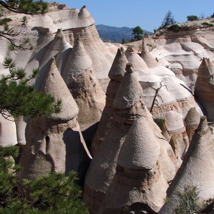
The Kasha-Katuwe Tent Rocks rise from the New Mexico desert as distinctive cone-shaped geological formations. These structures formed from volcanic deposits laid down 6 to 7 million years ago during eruptions from the Jemez volcanic field. Harder stone caps protect the softer pumice and tuff layers beneath from erosion, creating the tent-like shapes. A trail winds through the canyon between formations reaching up to 90 feet in height, exposing bands of volcanic ash, pumice, and rock fragments in varied colors from white to pink.
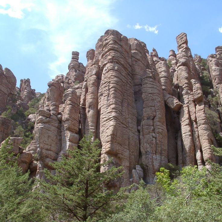
Chiricahua National Monument protects a volcanic area containing thousands of stone columns created by millions of years of erosion. The rock formations consist of layered rhyolite tuff and form structures resembling towers, columns, and balanced rocks. The site spans the Chiricahua Mountains and provides hiking trails through the geological formations. Apache tribes called this region the Land of Standing Rocks.
Devil's Garden sits within the Grand Staircase-Escalante National Monument and presents a collection of sandstone formations created through erosion processes. The geological structures include arches, towers, and rock spires in various shapes and sizes. The area spans several hectares and offers trails that wind between the formations. The red and orange sandstone rocks create contrasts against the desert sky and surrounding vegetation.
The Valley of Dreams consists of weathered sandstone pillars and geological formations shaped by wind and water erosion. The rock structures rise from the desert landscape and form natural sculptures in various shapes. This remote area in New Mexico displays layers of sedimentary rock in different shades of red and orange.
Zhangjiajie National Forest Park spans 480 square kilometers and features more than 3000 sandstone pillars rising from subtropical forest. These geological formations developed through erosion over millions of years, with some columns reaching heights of 300 meters. The park served as inspiration for the floating mountains in the film Avatar and includes several viewing platforms where visitors can photograph the rock formations. A glass-bottomed walkway connects some of the highest peaks, offering views into the valleys below.
Les Orgues d'Ille-sur-Têt is a geological site featuring rock formations sculpted by erosion. These vertical structures of sand and clay have been shaped over thousands of years by wind and water. The rocks form columns and walls resembling organ pipes, arranged in a natural amphitheater setting.
Gilf Kebir National Park spreads across a desert plateau in southwestern Egypt. Large chalk rock formations rise from the sandy plains, creating distinctive structures formed by millions of years of wind erosion. The area sits in one of the driest regions of the Sahara and displays geological layers from different epochs. The rock formations serve as photographic subjects and attract visitors who explore the remote desert terrain.
Davolja Varos presents over two hundred natural stone pillars formed through continuous erosion of volcanic tuff. These geological formations reach heights of up to fifteen meters and bear andesite blocks as protective caps. The area contains two acidic springs with high mineral content. The pyramid structures form as rainwater erodes softer material while exposing harder rock masses. This process continuously shapes the landscape, creating new pillars while older ones erode.
Caprock Canyons State Park spans 6,000 hectares in northern Texas and displays sandstone formations in shades of red and ochre. Erosion has carved deep canyons and distinct rock structures suitable for photography. The park preserves a section of the Palo Duro Canyon formation and provides hiking trails that traverse different geological layers. Visitors can photograph the natural rock formations from various perspectives.
The Toadstool Rock Formations feature red sandstone pedestals topped with balanced caprock boulders. These geological structures formed through differential erosion of rock layers over millions of years. A 1.5-mile hiking trail traverses the area within Grand Staircase-Escalante National Monument, providing access to multiple mushroom-shaped formations that rise from the surrounding badlands terrain.
Roque Cinchado is a 27-meter tall volcanic rock formation located in Teide National Park. This erosion-formed structure displays distinct layers of basalt and pumice stone. The rock stands on a narrow base and offers direct views of Mount Teide volcano, which rises to 3,718 meters as Spain's highest peak. The formation sits within the Las Cañadas mountain landscape at approximately 2,100 meters elevation.
The rock formations at Writing-on-Stone rise along the Milk River Valley and present more than 50 documented rock art sites created by the Blackfoot people. The sandstone cliffs display both carved petroglyphs and painted pictographs in mineral pigments, documenting different periods of Indigenous history. These archaeological records exist among weathered hoodoos and rock faces shaped by thousands of years of erosion.
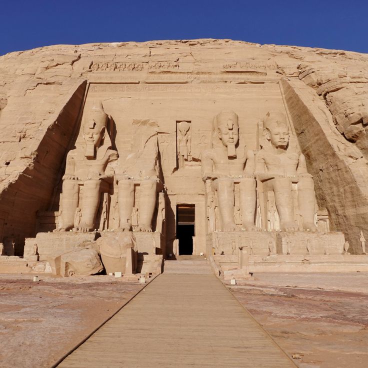
The Abu Simbel Temples were carved into rock cliffs in the 13th century BCE and rise from the western shore of Lake Nasser. The larger temple displays four seated colossal statues of Ramesses II on its facade, each approximately 20 meters tall. The smaller temple is dedicated to Queen Nefertari and the goddess Hathor. These structures were relocated 65 meters higher in the 1960s to protect them from the rising waters created by the Aswan High Dam.
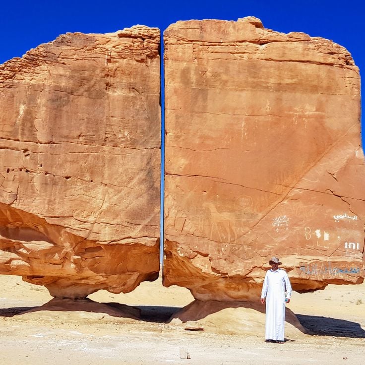
The Al Naslaa Rock Formation stands in the desert near Tayma and comprises two massive sandstone blocks separated by a perfectly straight vertical gap. The boulders rest on small pedestals and each weighs several tons. The precise split appears man-made but resulted from natural geological processes over thousands of years. Petroglyphs on the surface indicate that humans have known this formation since ancient times. The reddish-brown rocks contrast sharply with the pale desert sand and attract geologists and photographers alike.
The Demoiselles Coiffées de Pontis are geological formations consisting of rock columns topped with flat stone slabs. Erosion over millions of years shaped these structures that resemble figures wearing hats. The differential weathering of rock layers created these natural pillars in the Sasse valley.
The limestone pillars of the Twelve Apostles rise from the Southern Ocean along Victoria's Great Ocean Road. These geological formations developed through thousands of years of erosion by ocean waves and wind that shaped the soft limestone cliffs of the coastline. The remaining stacks stand in shallow water near the shore and provide views of natural coastal erosion processes.
Huángshān rises in Anhui Province and presents a series of granite peaks that frequently tower above the clouds. Weathering shaped these characteristic rock formations over millions of years. Narrow summits emerge from the mist and form distinct silhouettes. Pine trees grow directly from rock crevices and withstand the extreme conditions at this elevation. Geological processes created sharp contours and steep precipices that define the landscape.
The Garden of Eden in Arches National Park presents distinctive sandstone formations created through millions of years of natural erosion. This geological area displays freestanding columns and towers of red sandstone shaped by wind and water. The viewpoint provides direct access to these rock structures and allows photography of the characteristic stone architecture. The formation sits along the Park Avenue section and is accessible from the park's main road.
The Bisti Wilderness is a geological area in the New Mexico desert known for its unusual stone formations. These rounded structures were created through differential erosion of sandstone and shale layers over millions of years. The formations resemble large eggs and provide photographers with interesting subjects. This area lies away from main roads and requires hiking through open terrain.
Rattlesnake Arches sit within a remote section of the McInnis Canyons and provide access to more than 30 natural stone arches formed through millennia of erosion. The sandstone formations display various shades of red and orange, creating photographic subjects against the sky. Hiking trails lead through the terrain to multiple arches of varying sizes, with some formations spanning over 15 meters. The area lies far from paved roads and requires four-wheel-drive vehicles for access as well as adequate water supplies.
Hoodoo Basin in the northern section of Yellowstone National Park presents a geological depression filled with numerous stone pillars. These formations developed through the erosion of volcanic rock over thousands of years. The rock spires rise at varying heights from the basin floor, creating a maze of weathered volcanic stone. Access involves hiking trails through forested terrain, with the stone formations providing photogenic subjects under different lighting conditions.
The Geologic Park of Nebraska presents rock formations made of sandstone and clay, sculpted by erosion over the past 23 million years. The towers, pillars and rock walls extend across the grassland of the High Plains near Harrison. Visitors can walk among the geological structures and observe the different layers ranging from prehistoric marine deposits to volcanic ash.
This natural sandstone formation in Shoals rises 40 feet above the surrounding terrain and displays a distinctive shape with a narrow neck and wide base, resembling a water jug. Erosion has carved this geological structure from the bedrock over thousands of years. The monument sits within the forested region of Martin County and can be reached via a short hiking trail. The formation serves as an example of the geological processes that have shaped southern Indiana.
The rock formations of Canyonlands consist of red sandstone spires that extend across the desert landscape in the southeastern section of the park. These natural structures form extensive fields of rock columns and hoodoos, shaped by thousands of years of erosion. The area provides numerous vantage points for photographing the geometric patterns and the characteristic red-brown coloring of the sandstone.
This desert park in West Texas features numerous rock formations created by volcanic activity millions of years ago. The area sits within the Chihuahuan Desert and displays geological structures formed from solidified lava and tuff rock. The landscape consists of hoodoos, towers, and columns shaped by erosion over time. Visitors can access hiking trails to explore the various formations and observe the desert flora of the region.
Red Canyon presents rock formations in shades of orange and crimson that rise along sandstone cliffs. These geological structures are located just 5 kilometers from Bryce Canyon National Park and display similar erosion patterns with slender rock spires and layered sediment formations. The canyon sits along Scenic Byway 12 and serves as a gateway to the larger national park.
Coal Mine Canyon sits within the Navajo Reservation south of Tuba City, displaying eroded sandstone formations in shades of white, orange and purple. These geological structures, shaped by millions of years of erosion, rise from the desert floor as slender columns and towers. The unpaved access road leads to the canyon rim, where views reveal the colorful rock layers. This site receives considerably fewer visitors than other canyons in the region.
Hell's Half Acre spans 2000 acres of volcanic terrain formed by prehistoric lava flows from the Great Rift volcanic system. This basalt field displays dark spires, natural stone arches, and hardened lava formations rising from the Snake River Plain. The site provides numerous compositions for photography, with its network of black rock towers and eroded volcanic structures creating a varied landscape.
The City of Rocks National Reserve contains granite spires and monoliths that rise over 60 meters above the ground, formed through millions of years of erosion. This reserve spans 57 square kilometers in southern Idaho and displays numerous geological formations composed of Almo Pluton granite, which solidified approximately 28 million years ago. The distinctive rock structures served as a landmark for pioneers traveling the California Trail during the 19th century. Today, the area attracts climbers, hikers, and photographers who document the unusual stone formations and expansive views across the high desert landscape.
Bryce Canyon National Park sits on the Colorado Plateau at elevations between 2,400 and 2,700 meters. The park's distinctive rock towers, called hoodoos, formed through frost weathering and water erosion of red limestone layers. The amphitheater extends several kilometers and displays varying rock colors from orange to red to white. Multiple hiking trails wind between the formations and provide different perspectives on the geological structures.
The Fairy Chimneys of Cappadocia are tall rock formations created by the erosion of volcanic ash deposits. Harder rock caps protect the softer rock beneath, forming distinctive cone shapes. These geological structures define the region's landscape and attract photographers from around the world. The formations vary in height and shape, with some reaching several meters tall.
Göreme National Park is located in Cappadocia and displays rock formations of tuff stone created by volcanic activity and erosion. The area contains cave dwellings, Byzantine churches with frescoes dating from the 10th to 12th centuries, and underground cities. The characteristic fairy chimneys and rock cones form a landscape that has been inhabited since Roman times.
Tsingy de Bemaraha National Park protects an extensive landscape of limestone needles formed through centuries of erosion. The grey rock formations rise up to 70 meters high, creating an impenetrable labyrinth of sharp pinnacles. Deep gorges and caves run between the rocks, where adapted flora and fauna have developed. The area encompasses dry deciduous forests and several rivers that wind through the limestone formation.
The Drumheller Hoodoos are geological formations of sandstone and mudstone rising from the Red Deer River Valley. These stone columns formed through millennia of erosion, where softer rock layers beneath harder cap rocks were worn away by wind and water. Located approximately ten kilometers east of Drumheller, the hoodoos provide direct access via a paved pathway with viewing platforms for photographers.
The Belogradchik Rocks are composed of red sandstone and limestone formations shaped by tectonic movements, erosion, and weathering over 230 million years. These geological structures rise up to 200 meters in height and span approximately 90 square kilometers in northwestern Bulgaria. The various rock groups bear local names based on their distinctive shapes created by natural processes.
The Ah-Shi-Sle-Pah Wilderness Study Area covers 6,563 acres of public land in northwestern New Mexico. This remote desert terrain displays heavily eroded Cretaceous sediment layers forming unusual rock formations, slender hoodoos, and grey clay hills. Fossil beds and petrified wood lie scattered throughout the barren landscape. The isolated location requires four-wheel drive vehicles to access, with no paved roads leading into the area.
The Kasha-Katuwe Tent Rocks rise from the New Mexico desert as distinctive cone-shaped geological formations. These structures formed from volcanic deposits laid down 6 to 7 million years ago during eruptions from the Jemez volcanic field. Harder stone caps protect the softer pumice and tuff layers beneath from erosion, creating the tent-like shapes. A trail winds through the canyon between formations reaching up to 90 feet in height, exposing bands of volcanic ash, pumice, and rock fragments in varied colors from white to pink.
Chiricahua National Monument protects a volcanic area containing thousands of stone columns created by millions of years of erosion. The rock formations consist of layered rhyolite tuff and form structures resembling towers, columns, and balanced rocks. The site spans the Chiricahua Mountains and provides hiking trails through the geological formations. Apache tribes called this region the Land of Standing Rocks.
Devil's Garden sits within the Grand Staircase-Escalante National Monument and presents a collection of sandstone formations created through erosion processes. The geological structures include arches, towers, and rock spires in various shapes and sizes. The area spans several hectares and offers trails that wind between the formations. The red and orange sandstone rocks create contrasts against the desert sky and surrounding vegetation.
The Valley of Dreams consists of weathered sandstone pillars and geological formations shaped by wind and water erosion. The rock structures rise from the desert landscape and form natural sculptures in various shapes. This remote area in New Mexico displays layers of sedimentary rock in different shades of red and orange.
Zhangjiajie National Forest Park spans 480 square kilometers and features more than 3000 sandstone pillars rising from subtropical forest. These geological formations developed through erosion over millions of years, with some columns reaching heights of 300 meters. The park served as inspiration for the floating mountains in the film Avatar and includes several viewing platforms where visitors can photograph the rock formations. A glass-bottomed walkway connects some of the highest peaks, offering views into the valleys below.
Les Orgues d'Ille-sur-Têt is a geological site featuring rock formations sculpted by erosion. These vertical structures of sand and clay have been shaped over thousands of years by wind and water. The rocks form columns and walls resembling organ pipes, arranged in a natural amphitheater setting.
Gilf Kebir National Park spreads across a desert plateau in southwestern Egypt. Large chalk rock formations rise from the sandy plains, creating distinctive structures formed by millions of years of wind erosion. The area sits in one of the driest regions of the Sahara and displays geological layers from different epochs. The rock formations serve as photographic subjects and attract visitors who explore the remote desert terrain.
Davolja Varos presents over two hundred natural stone pillars formed through continuous erosion of volcanic tuff. These geological formations reach heights of up to fifteen meters and bear andesite blocks as protective caps. The area contains two acidic springs with high mineral content. The pyramid structures form as rainwater erodes softer material while exposing harder rock masses. This process continuously shapes the landscape, creating new pillars while older ones erode.
Caprock Canyons State Park spans 6,000 hectares in northern Texas and displays sandstone formations in shades of red and ochre. Erosion has carved deep canyons and distinct rock structures suitable for photography. The park preserves a section of the Palo Duro Canyon formation and provides hiking trails that traverse different geological layers. Visitors can photograph the natural rock formations from various perspectives.
The Toadstool Rock Formations feature red sandstone pedestals topped with balanced caprock boulders. These geological structures formed through differential erosion of rock layers over millions of years. A 1.5-mile hiking trail traverses the area within Grand Staircase-Escalante National Monument, providing access to multiple mushroom-shaped formations that rise from the surrounding badlands terrain.
Roque Cinchado is a 27-meter tall volcanic rock formation located in Teide National Park. This erosion-formed structure displays distinct layers of basalt and pumice stone. The rock stands on a narrow base and offers direct views of Mount Teide volcano, which rises to 3,718 meters as Spain's highest peak. The formation sits within the Las Cañadas mountain landscape at approximately 2,100 meters elevation.
The rock formations at Writing-on-Stone rise along the Milk River Valley and present more than 50 documented rock art sites created by the Blackfoot people. The sandstone cliffs display both carved petroglyphs and painted pictographs in mineral pigments, documenting different periods of Indigenous history. These archaeological records exist among weathered hoodoos and rock faces shaped by thousands of years of erosion.
The Abu Simbel Temples were carved into rock cliffs in the 13th century BCE and rise from the western shore of Lake Nasser. The larger temple displays four seated colossal statues of Ramesses II on its facade, each approximately 20 meters tall. The smaller temple is dedicated to Queen Nefertari and the goddess Hathor. These structures were relocated 65 meters higher in the 1960s to protect them from the rising waters created by the Aswan High Dam.
The Al Naslaa Rock Formation stands in the desert near Tayma and comprises two massive sandstone blocks separated by a perfectly straight vertical gap. The boulders rest on small pedestals and each weighs several tons. The precise split appears man-made but resulted from natural geological processes over thousands of years. Petroglyphs on the surface indicate that humans have known this formation since ancient times. The reddish-brown rocks contrast sharply with the pale desert sand and attract geologists and photographers alike.
The Demoiselles Coiffées de Pontis are geological formations consisting of rock columns topped with flat stone slabs. Erosion over millions of years shaped these structures that resemble figures wearing hats. The differential weathering of rock layers created these natural pillars in the Sasse valley.
The limestone pillars of the Twelve Apostles rise from the Southern Ocean along Victoria's Great Ocean Road. These geological formations developed through thousands of years of erosion by ocean waves and wind that shaped the soft limestone cliffs of the coastline. The remaining stacks stand in shallow water near the shore and provide views of natural coastal erosion processes.
Huángshān rises in Anhui Province and presents a series of granite peaks that frequently tower above the clouds. Weathering shaped these characteristic rock formations over millions of years. Narrow summits emerge from the mist and form distinct silhouettes. Pine trees grow directly from rock crevices and withstand the extreme conditions at this elevation. Geological processes created sharp contours and steep precipices that define the landscape.
The Garden of Eden in Arches National Park presents distinctive sandstone formations created through millions of years of natural erosion. This geological area displays freestanding columns and towers of red sandstone shaped by wind and water. The viewpoint provides direct access to these rock structures and allows photography of the characteristic stone architecture. The formation sits along the Park Avenue section and is accessible from the park's main road.
The Bisti Wilderness is a geological area in the New Mexico desert known for its unusual stone formations. These rounded structures were created through differential erosion of sandstone and shale layers over millions of years. The formations resemble large eggs and provide photographers with interesting subjects. This area lies away from main roads and requires hiking through open terrain.
Rattlesnake Arches sit within a remote section of the McInnis Canyons and provide access to more than 30 natural stone arches formed through millennia of erosion. The sandstone formations display various shades of red and orange, creating photographic subjects against the sky. Hiking trails lead through the terrain to multiple arches of varying sizes, with some formations spanning over 15 meters. The area lies far from paved roads and requires four-wheel-drive vehicles for access as well as adequate water supplies.
Hoodoo Basin in the northern section of Yellowstone National Park presents a geological depression filled with numerous stone pillars. These formations developed through the erosion of volcanic rock over thousands of years. The rock spires rise at varying heights from the basin floor, creating a maze of weathered volcanic stone. Access involves hiking trails through forested terrain, with the stone formations providing photogenic subjects under different lighting conditions.
The Geologic Park of Nebraska presents rock formations made of sandstone and clay, sculpted by erosion over the past 23 million years. The towers, pillars and rock walls extend across the grassland of the High Plains near Harrison. Visitors can walk among the geological structures and observe the different layers ranging from prehistoric marine deposits to volcanic ash.
This natural sandstone formation in Shoals rises 40 feet above the surrounding terrain and displays a distinctive shape with a narrow neck and wide base, resembling a water jug. Erosion has carved this geological structure from the bedrock over thousands of years. The monument sits within the forested region of Martin County and can be reached via a short hiking trail. The formation serves as an example of the geological processes that have shaped southern Indiana.
The rock formations of Canyonlands consist of red sandstone spires that extend across the desert landscape in the southeastern section of the park. These natural structures form extensive fields of rock columns and hoodoos, shaped by thousands of years of erosion. The area provides numerous vantage points for photographing the geometric patterns and the characteristic red-brown coloring of the sandstone.
This desert park in West Texas features numerous rock formations created by volcanic activity millions of years ago. The area sits within the Chihuahuan Desert and displays geological structures formed from solidified lava and tuff rock. The landscape consists of hoodoos, towers, and columns shaped by erosion over time. Visitors can access hiking trails to explore the various formations and observe the desert flora of the region.
Red Canyon presents rock formations in shades of orange and crimson that rise along sandstone cliffs. These geological structures are located just 5 kilometers from Bryce Canyon National Park and display similar erosion patterns with slender rock spires and layered sediment formations. The canyon sits along Scenic Byway 12 and serves as a gateway to the larger national park.
Coal Mine Canyon sits within the Navajo Reservation south of Tuba City, displaying eroded sandstone formations in shades of white, orange and purple. These geological structures, shaped by millions of years of erosion, rise from the desert floor as slender columns and towers. The unpaved access road leads to the canyon rim, where views reveal the colorful rock layers. This site receives considerably fewer visitors than other canyons in the region.
Hell's Half Acre spans 2000 acres of volcanic terrain formed by prehistoric lava flows from the Great Rift volcanic system. This basalt field displays dark spires, natural stone arches, and hardened lava formations rising from the Snake River Plain. The site provides numerous compositions for photography, with its network of black rock towers and eroded volcanic structures creating a varied landscape.
The City of Rocks National Reserve contains granite spires and monoliths that rise over 60 meters above the ground, formed through millions of years of erosion. This reserve spans 57 square kilometers in southern Idaho and displays numerous geological formations composed of Almo Pluton granite, which solidified approximately 28 million years ago. The distinctive rock structures served as a landmark for pioneers traveling the California Trail during the 19th century. Today, the area attracts climbers, hikers, and photographers who document the unusual stone formations and expansive views across the high desert landscape.