Al Naslaa, Sandstone rock formation with petroglyphs in Tayma, Saudi Arabia
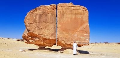
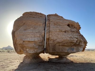
Al Naslaa is a sandstone rock about 6 metres high and 9 metres wide, split down the middle into two blocks that each rest on a small pedestal, with a narrow straight gap between them. Its south-east face carries numerous petroglyphs, including horses and ibex, and the reddish-orange stone shows horizontal bedding lines.
The Tayma oasis area was first investigated and mapped by Charles M. Doughty in 1877, and his collected material appeared in "Travels in Arabia Deserta" in 1888. In 1883 the French explorer Charles Huber reached Al Naslaa and reported the rock's split condition, which the sources say remains as he found it.
The south-east face carries numerous petroglyphs, among them depictions of horses and ibex. The Arabic name صخرة النصلة refers to the split itself. The French explorer Charles Huber reached the rock in 1883 and reported its condition, which he found unchanged from earlier accounts.
Al Naslaa lies about 50 km south of the Tayma oasis, reached by desert track, so a 4x4 and a local guide familiar with the route are advisable. The rock stands on open sand with no shade or facilities; bring water and sun protection and plan the visit for the cooler morning hours. The petroglyphs are on the south-east face, which is best lit early in the day.
The petroglyphs on the south-east face include depictions of horses and ibex, and faint white graffiti letters such as "B" and "U" are also visible on the lower right block. Geologists still debate whether the straight gap comes from natural jointing, tectonic fracturing or freeze–thaw weathering.
The community of curious travelers
AroundUs brings together thousands of curated places, local tips, and hidden gems, enriched daily by 92,323 contributors worldwide.