Stone pillars, salt flats, and caverns reveal how nature shapes the land through time.
Across the globe, geological formations reveal how nature works over vast stretches of time. Wind, water, and volcanic forces have carved out some of Earth's most remarkable landscapes. In Arizona, Antelope Canyon shows bands of colored sandstone worn smooth by water. In Northern Ireland, the Giant's Causeway displays thousands of stone columns that formed when lava cooled. In Turkey, Pamukkale terraces shimmer white with minerals left behind by hot springs.
These sites appear on every continent and take many different forms. Madagascar's Tsingy de Bemaraha features sharp limestone peaks rising like a forest of stone. New Zealand's Moeraki Boulders sit on the beach as massive round rocks smoothed by the ocean. Bolivia's Salar de Uyuni spreads as a vast white expanse of salt. Vietnam's Ha Long Bay contains thousands of limestone islands jutting from the water, each shaped by centuries of wave action.
Visitors can walk through many of these places and see how they formed. Zhangjiajie National Forest Park in China inspired filmmakers with its towering sandstone pillars. Wyoming's Grand Prismatic Spring displays rings of color created by heat-loving bacteria that live in water at different temperatures. From the cone-shaped Chocolate Hills in the Philippines to volcanic Jeju Island in South Korea, these formations tell the story of how Earth has changed and continues to change.
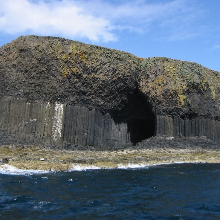
Fingal's Cave is a sea cave on the uninhabited Hebridean island of Staffa. Its walls are made of hexagonal basalt columns that formed around 60 million years ago as lava slowly cooled. The entrance faces the sea and floods partially at high tide. The natural acoustics of the cave inspired Felix Mendelssohn to compose his Hebrides Overture after his visit in 1829.
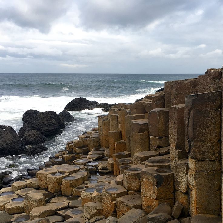
The Giant's Causeway sits on the north coast of Northern Ireland and is made up of around 40,000 basalt columns, most of them hexagonal. They formed about 60 million years ago when molten rock pushed to the surface and cooled slowly. Walking across this natural stone pavement, which runs from the cliffs down to the sea, gives a clear sense of just how powerful the volcanic forces were that shaped this coastline.
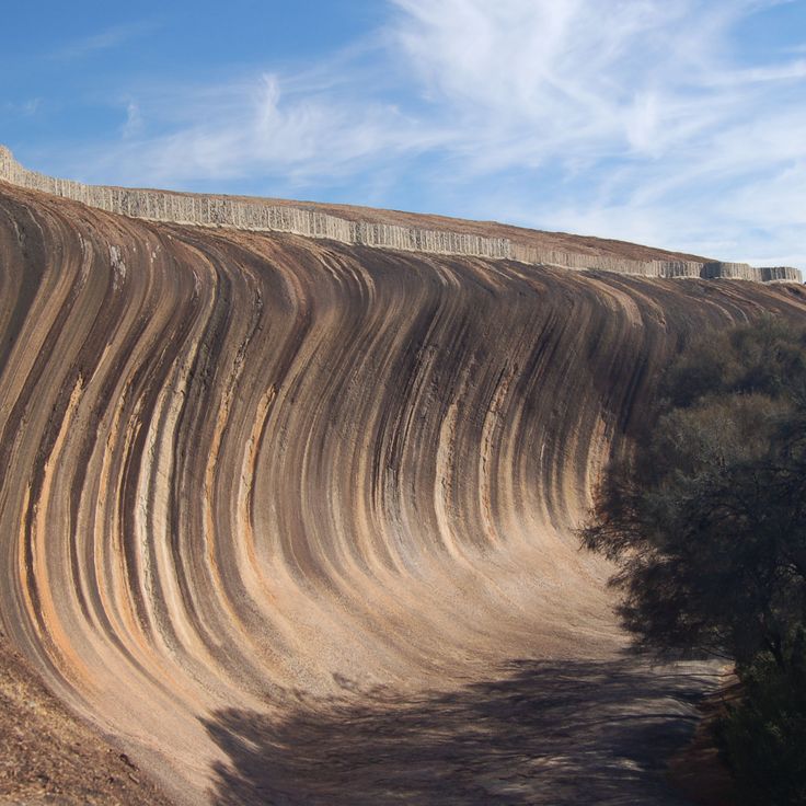
Wave Rock is a granite wall in Western Australia shaped like a breaking ocean wave. The rock is around 2.7 billion years old and was carved into its curved form by wind, water, and chemical weathering over time. Vertical stripes of gray, red, and ochre run down the face of the rock, left behind by minerals that washed down the surface over countless ages. Like other formations in this collection, Wave Rock shows how natural forces can reshape stone across deep stretches of time.
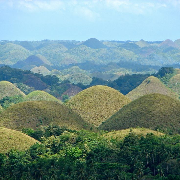
The Chocolate Hills are a large group of cone-shaped hills in the center of Bohol island. They formed when coral limestone was gradually worn down by rain and groundwater over millions of years. During the dry season, the grass turns brown across all the hills, which is how they got their name. Travelers passing through the area see these evenly shaped mounds stretching in every direction.
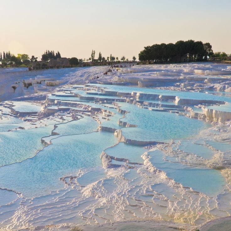
The travertines of Pamukkale formed over thousands of years as mineral-rich thermal water flowed down the hillside, leaving behind layers of white calcium carbonate. The water rises from underground springs and spills over stepped pools that run along the edge of the Taurus Mountains. Pamukkale, which means 'cotton castle' in Turkish, is both a geological site and a place where visitors can walk barefoot through shallow warm pools.
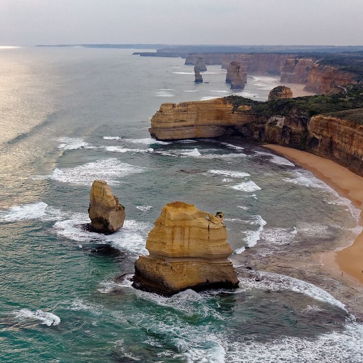
The Apostles are a group of limestone stacks rising from the sea off the coast of Port Campbell, in Victoria, Australia. Over millions of years, waves and wind wore away the sandstone cliffs along this shore, leaving these isolated pillars standing in the Southern Ocean. Some rise as tall as 145 feet (45 meters). The ocean continues to shape them today, slowly changing their form. Walking along the clifftops here gives a clear sense of how water works on rock over time.
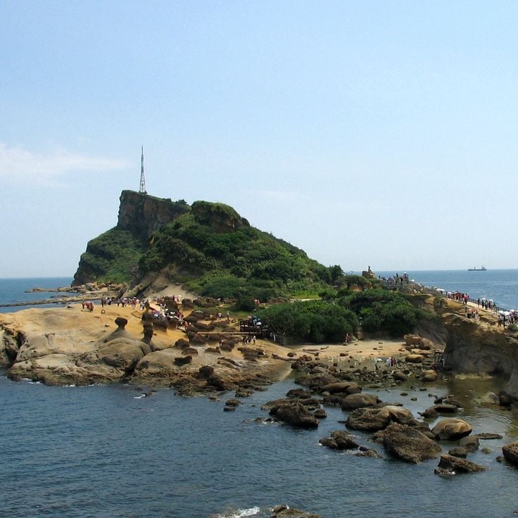
Yehliu Geopark sits on a narrow strip of land along Taiwan's northern coast, where the sea has slowly shaped the sandstone over thousands of years. Walking through the site, you can see rocks that look like mushrooms, with thin stems and wide tops, as well as honeycomb patterns worn into the stone and tall, candle-shaped pillars. Each shape tells you something about how harder and softer layers of rock respond differently to waves, wind, and salt. Few places in Taiwan show marine erosion so clearly.
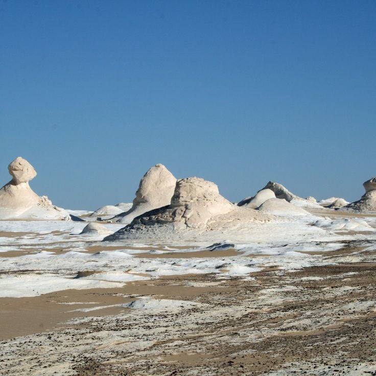
The White Desert sits north of the Farafra Oasis in Egypt's Western Sahara. Over thousands of years, wind and sand have carved white limestone rocks into shapes that resemble mushrooms, cones, and abstract figures rising from the ground. These pale formations stand out sharply against the surrounding sandy floor and offer a clear picture of how wind alone can slowly reshape stone in a dry climate.
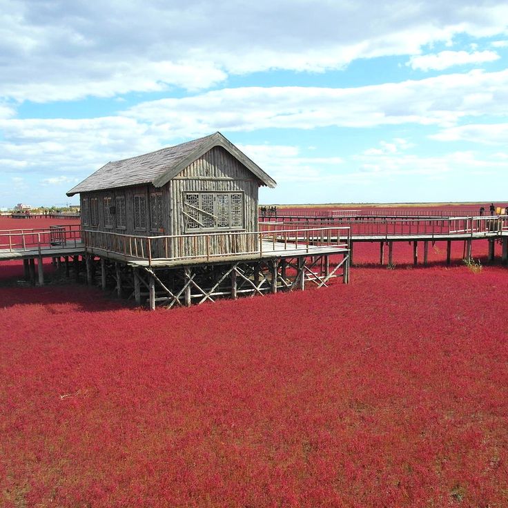
Red Beach sits in the Liaohe River delta in Liaoning province and turns a deep red each autumn. The color comes from Suaeda salsa, a plant that thrives in salty soil and changes color as the season shifts. Wooden boardwalks let visitors walk through reed fields, salt marshes, and tidal flats. The wetland is also a stop for migratory birds traveling along the East Asian flyway, making it a place where geological and natural processes are easy to observe side by side.
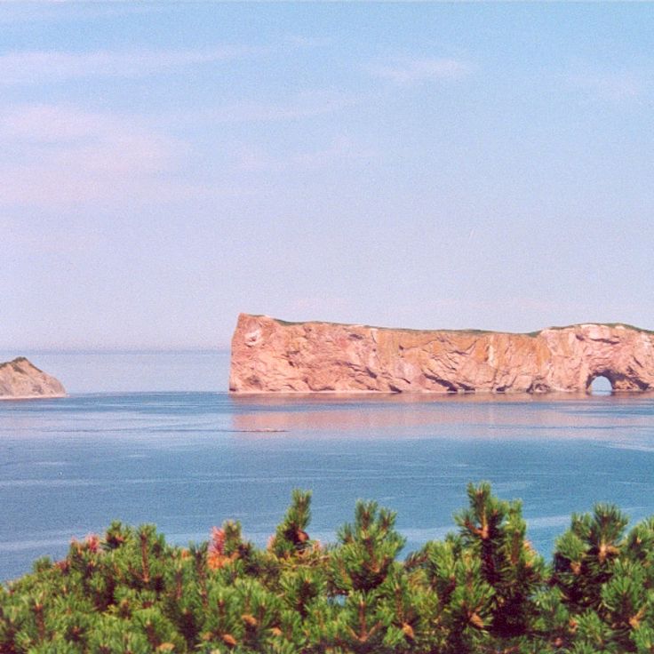
Percé Rock rises from the Gulf of Saint Lawrence at the tip of the Gaspé Peninsula in Quebec. This limestone formation is around 375 million years old and carries layers of ancient seafloor rock that you can see clearly from the shore. A natural arch worn through by seawater opens in its face, a sign of how the ocean slowly reshapes stone. At low tide, visitors can walk out to the base and watch thousands of gannets nesting on the cliffs above.
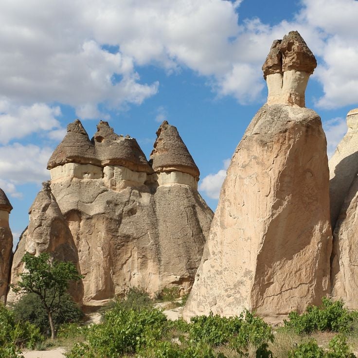
The Fairy Chimneys of Cappadocia formed through volcanic activity and long erosion over a very long period of time. Softer tuff built up beneath harder basalt caps that protected the stone below from weathering. In the valleys of the region, these cone-shaped towers rise up to about 130 feet (40 meters) tall. Early Christian communities carved many of them out to create homes and churches that are still visible today.
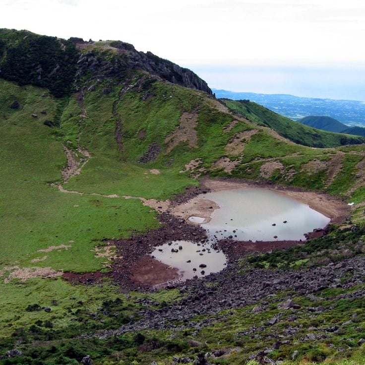
Jeju Volcanic Island shows what millions of years of volcanic activity can do to a landscape. Hardened lava flows shape the coastline, dark basalt rock covers much of the interior, and craters mark where magma once pushed through the surface. Waterfalls drop over black stone, and the whole island reads like a record of how fire and time work together to build land.
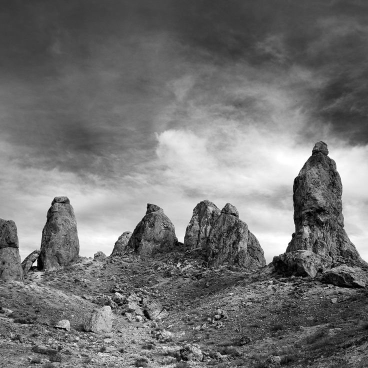
The Trona Pinnacles rise from the floor of the Mojave Desert in California as a field of tufa towers, some reaching about 140 feet (43 meters) tall. Tens of thousands of years ago, a lake covered this area. As the water receded, minerals dissolved in the alkaline water slowly solidified into these columns. Today they stand in a flat, open desert setting that feels unlike almost anywhere else. Film crews have used this spot as a backdrop, and the land is open to the public.
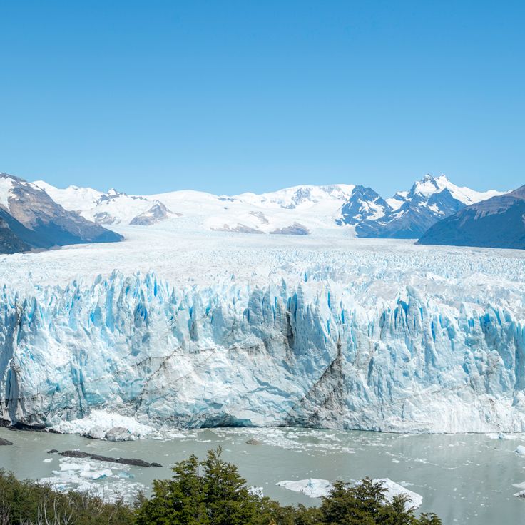
Los Glaciares sits in the Patagonian Andes and holds one of the largest ice fields outside the poles. The ice feeds around 47 glaciers, including valley glaciers that have carved deep fjords and lakes over time. The most visited is the Perito Moreno glacier, whose ice front regularly breaks off and falls into the lake below. Standing here, you can hear the ice crack and thunder as one of the last great moving glaciers on Earth shifts in front of you.
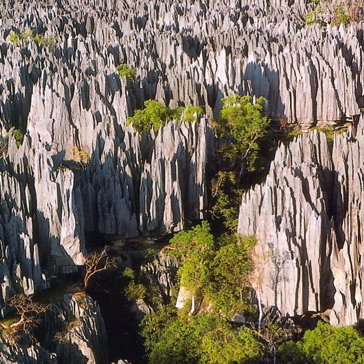
The Tsingy de Bemaraha shows what happens when limestone is worn away by water and wind over thousands of years. The result is a forest of sharp stone spires packed closely together and separated by narrow gorges. Some of these spires reach about 150 feet (46 meters) high. Between the rocks, plants and animals have adapted to life in this unusual environment, many found nowhere else. This site stands as one of the clearest examples in this collection of how erosion can reshape the land over long stretches of time.
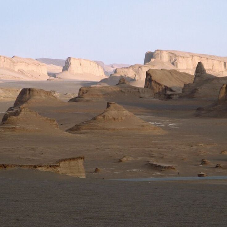
Dasht-e Lut sits in southeastern Iran and is one of the hottest and driest places on Earth. This salt desert fits naturally into a collection about geological wonders, as wind has spent millions of years carving rocks into unusual shapes. Ground temperatures in summer can rise above 160 degrees Fahrenheit (70 degrees Celsius). Walking across it, you find salt crusts, rolling sand structures, and wind-worn rock masses that show just how powerfully an extreme dry climate reshapes the land.
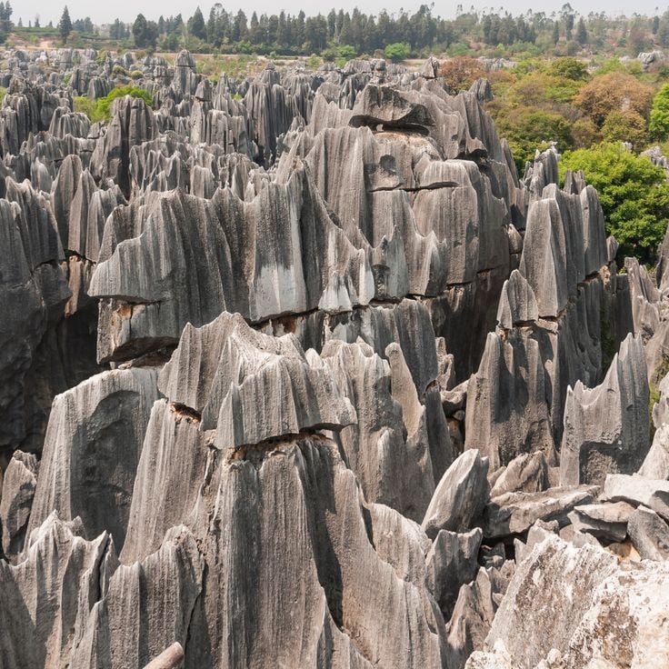
The Stone Forest in Shilin is a karst landscape made of gray limestone columns that rise high above the ground and look like a forest of stone. Around 270 million years ago, this place was a seafloor. Tectonic forces pushed it upward, and rain slowly dissolved the rock, carving it into these dense pillars over a vast stretch of time. Visitors can walk along marked paths between the formations and explore different areas, from tall open columns to tighter, denser groupings. The site has been part of the UNESCO World Heritage South China Karst since 2007.
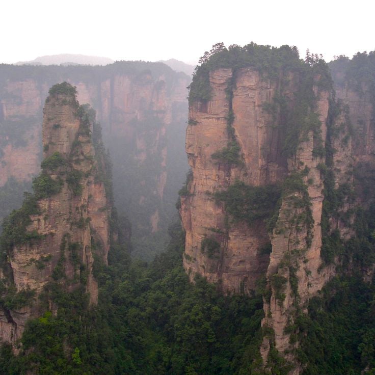
Zhangjiajie National Forest Park, in Hunan Province, is home to more than 3,000 quartzite sandstone pillars shaped by erosion over 380 million years. The pillars, covered in subtropical vegetation, rise up to 660 feet (200 meters) and connect through limestone caves, gorges, and natural bridges. Visitors move through the park by cable car, glass walkway, or hiking trail. The landscape here inspired filmmakers looking for otherworldly settings.
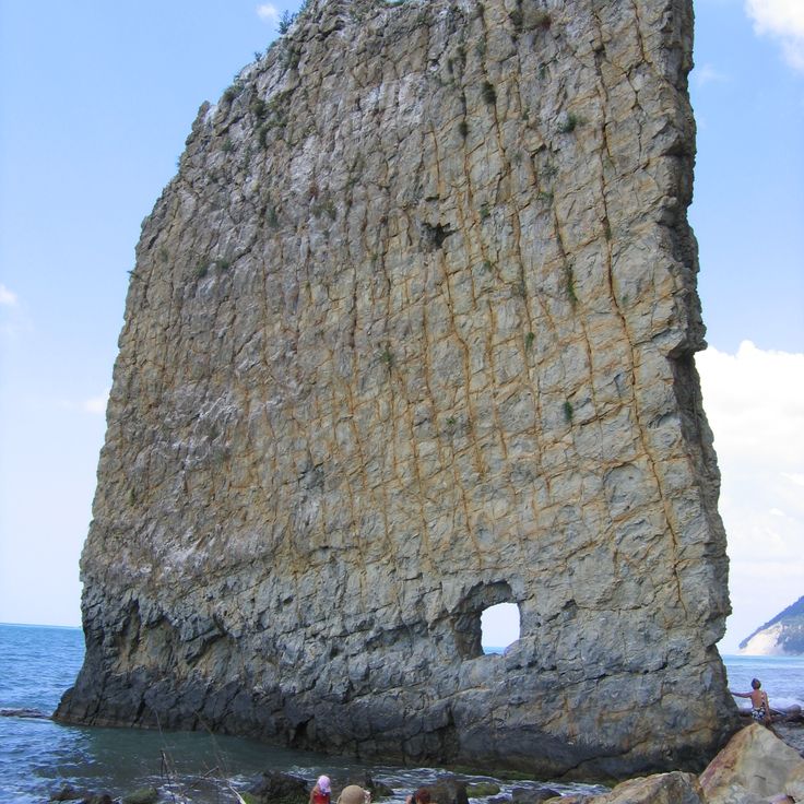
Sail Rock is a freestanding sandstone pillar that rises 30 meters (about 100 feet) on the Black Sea shore south of Gelendzhik. Waves gradually separated it from the mainland and carved a rectangular opening near its base. It is a clear example of how softer rock wears away faster than harder layers, leaving behind an isolated column.
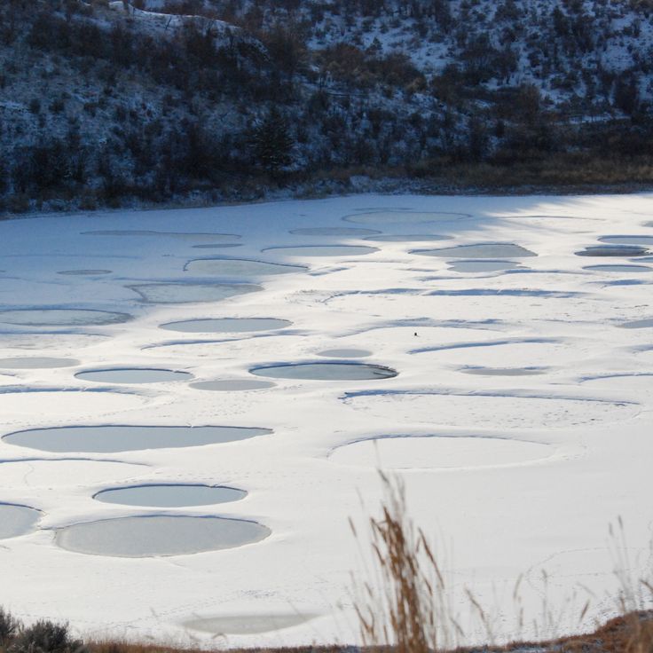
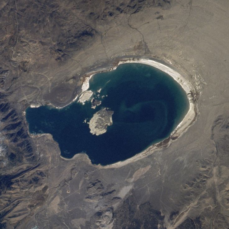
Spotted Lake is one of the most unusual geological sites in the world. In summer, as the water evaporates, the surface breaks into colored mineral circles. Each spot has a different shade because the mineral salts concentrate in separate pools. The water is rich in magnesium sulfate, calcium sulfate, and sodium sulfate, with traces of silver and titanium. The lake sits on Okanagan Nation territory, where it has been used and respected by indigenous people for centuries.
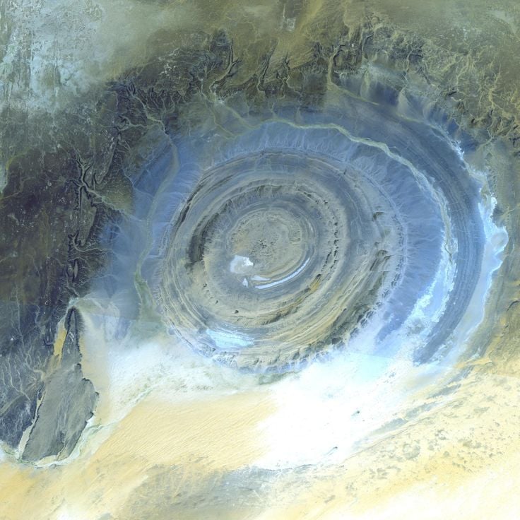
The Eye of the Sahara is a circular rock formation rising from the desert of Mauritania. Wind and erosion have worn away the surface over millions of years, exposing layers of sedimentary and volcanic rock arranged in concentric rings. From the air, the formation looks like a giant eye staring up from the sand. It shows, in a very direct way, how deep time leaves its mark on the ground beneath our feet.
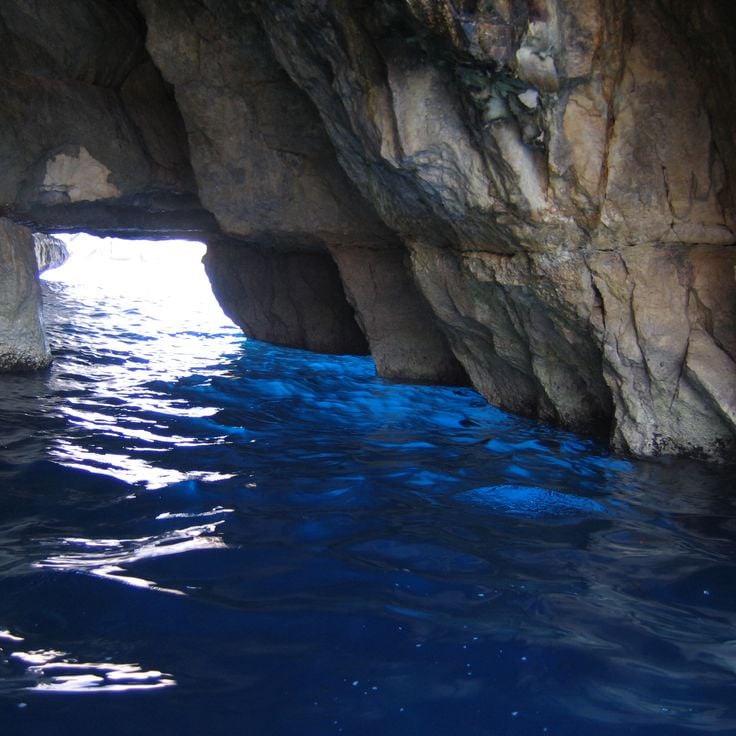
The Blue Grotto is a sea cave on the island of Capri where the water glows with a deep, vivid blue light. This effect happens because sunlight enters through an opening below the waterline and lights up the cave from within. Visitors have been drawn here since the 19th century to experience the glowing interior. The cave reaches about 200 feet (60 meters) into the cliff and entry is only possible through a narrow gap at sea level, lying flat in a small rowboat.
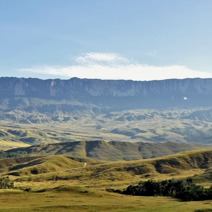
Mount Roraima is a flat-topped mountain sitting at the border of Venezuela, Brazil, and Guyana. Its vertical sandstone walls have been shaped by erosion over two billion years, making it one of South America's oldest geological formations. The plateau at the top has its own microclimate, and many plants and animals found there live nowhere else on Earth. Walking here feels like stepping onto a different world altogether.
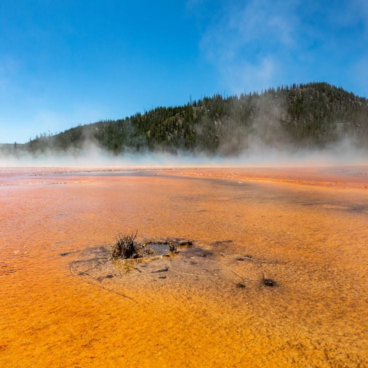
Grand Prismatic Spring sits in Yellowstone National Park and is one of the largest hot springs in the world. What draws most visitors is the pattern of colored rings around the water: yellow, orange, green, and brown bands that come from bacteria living at different water temperatures. The center stays too hot for anything to survive, and the deep blue there comes from the way light moves through the water. Steam rises from the surface year-round, and a boardwalk lets visitors walk close to the edge.
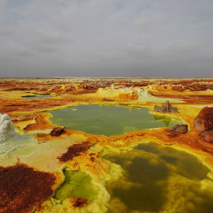
The Danakil Depression sits more than 300 feet (100 meters) below sea level and is one of the hottest inhabited places on Earth. Sulfur springs in shades of yellow and green, wide salt flats, and active lava lakes fill this hollow in the East African Rift, shaped by ongoing volcanic forces. Temperatures regularly reach 120 degrees Fahrenheit (50 degrees Celsius), making it one of the most geologically raw places a traveler can visit.
Mono Lake sits in eastern California and is one of the oldest lakes in North America. What makes this lake so recognizable are its tufa towers, columns of calcium carbonate that rise straight out of the water. They form where calcium-rich freshwater springs meet the salty lake water below the surface. The water is too salty for most life, but brine shrimp and alkali flies thrive here, drawing large numbers of migratory birds each season.
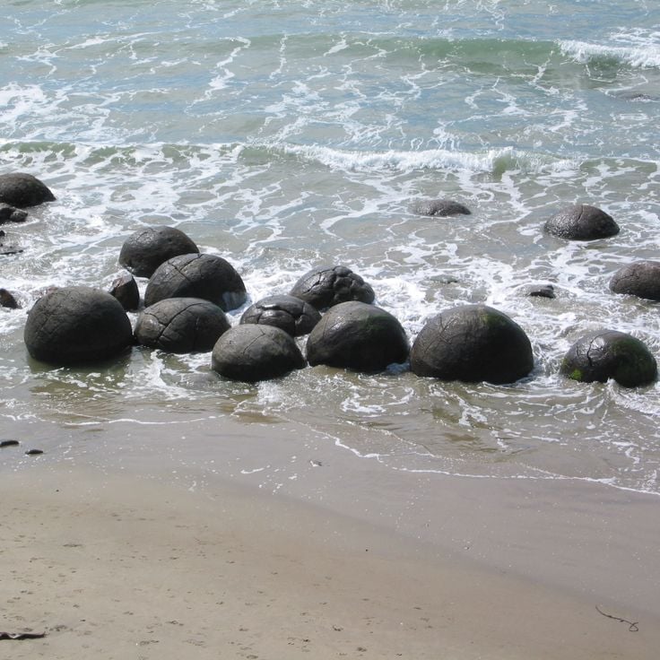
The Moeraki Boulders are large, round rocks scattered along Koekohe Beach on New Zealand's Otago coast. They formed over millions of years as minerals built up around a core in the seafloor mud, which slowly hardened into stone. Some have cracked open, showing the crystalline inside. Like other places in this collection, the Moeraki Boulders show how time and natural forces shape the earth beneath our feet.
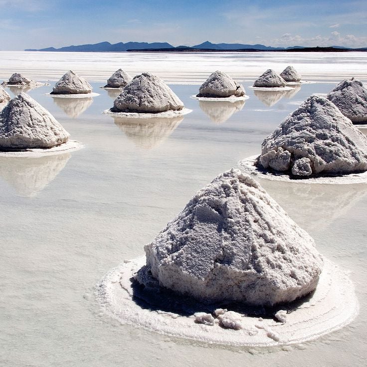
Salar de Uyuni sits on the Bolivian Altiplano and is the largest salt flat on Earth. It formed thousands of years ago when prehistoric lakes dried up and left behind a thick crust of salt. After rain, a thin layer of water covers the ground and turns the whole surface into a giant mirror that reflects the sky and the mountains around it. Walking across it, you feel as if the ground and the sky have merged into one.
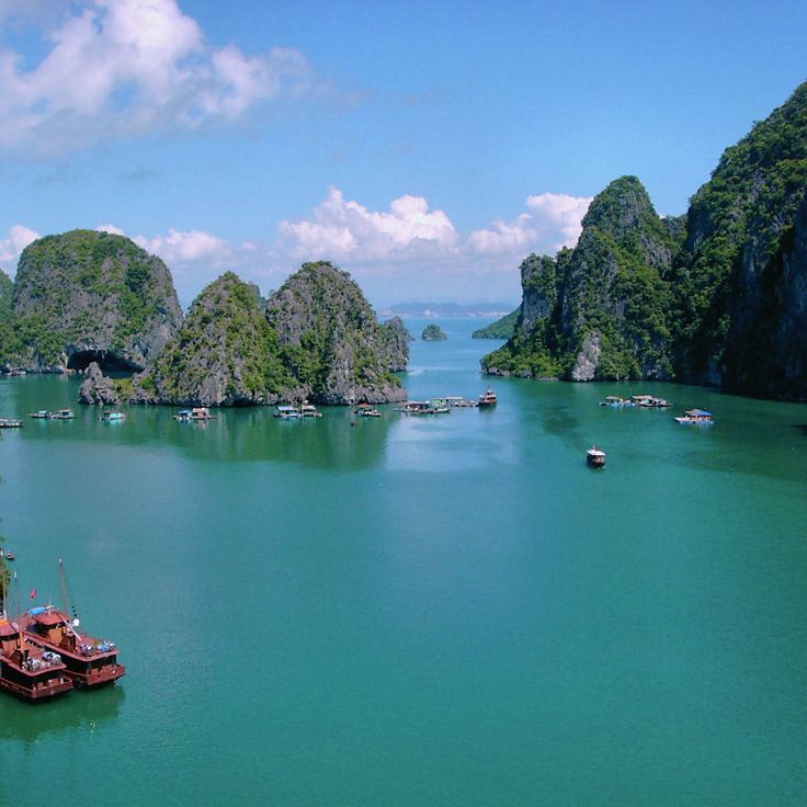
Ha Long Bay in northern Vietnam is a stretch of sea where more than 1,600 limestone islands rise from the water. These formations took shape over hundreds of millions of years, as geological forces and shifting sea levels gradually wore down the rock. Most islands stand steep and sharp, with hollow caves carved into them by wave action. A few floating fishing villages sit among the islands, giving the bay a sense of daily life alongside all that stone.
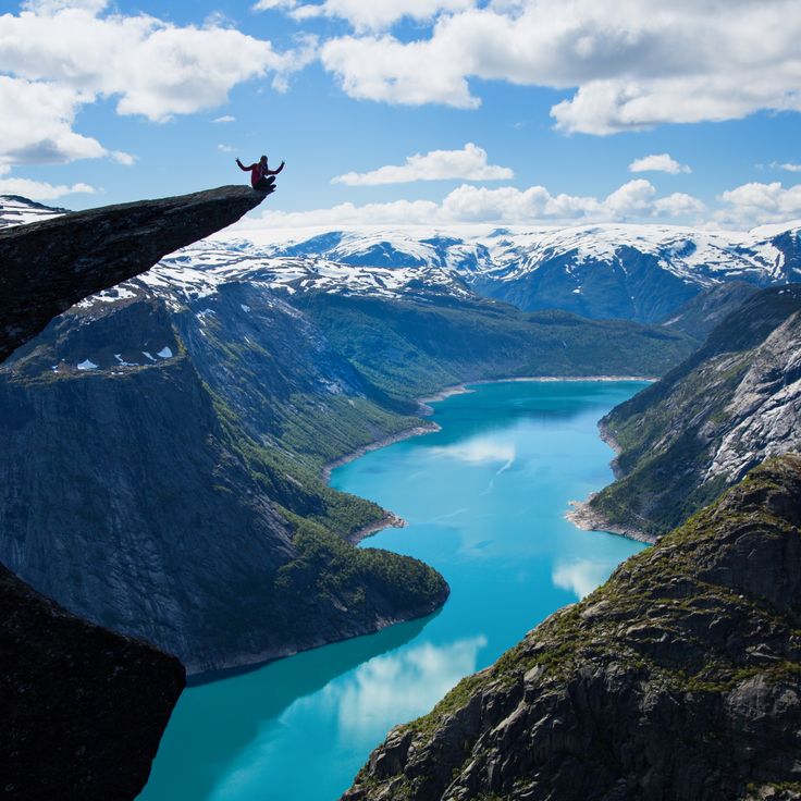
Trolltunga is a slab of rock that juts out horizontally from Mount Skjeggedal, hanging above Lake Ringedalsvatnet some 700 meters below. This formation took shape around 10,000 years ago, when glaciers wore away the surrounding rock and left behind this protruding tongue of bedrock. The area was once buried under thick inland ice during the last glacial period, and what remains today is a direct result of that slow, powerful process.
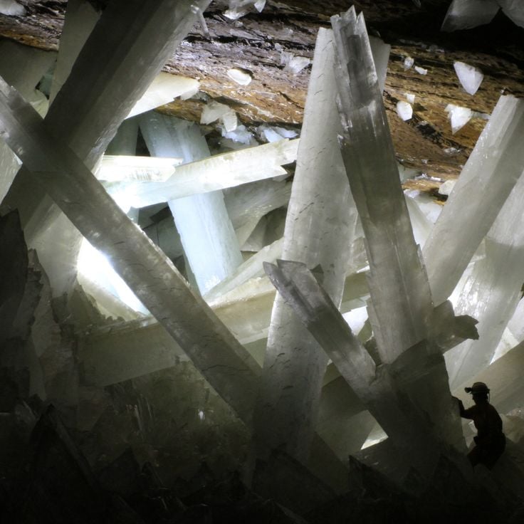
The Cave of Crystals sits about 1,000 feet (300 meters) below the Naica Mine in Mexico. Inside, selenite crystals grow up to 36 feet (11 meters) long and can weigh several tons. The heat inside reaches around 122°F (50°C), so anyone without protective equipment can only stay for a few minutes. These crystals formed over roughly 500,000 years under steady geological conditions, making this cave one of the most telling examples of how the Earth shapes stone over time.
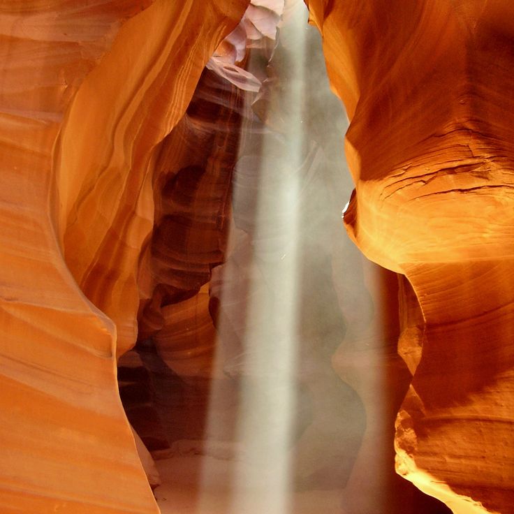
Antelope Canyon is a narrow slot canyon carved into red Navajo Sandstone in northern Arizona. Over thousands of years, flash floods pushed through tight openings and shaped the rock into smooth, curving walls. Light filters down from a gap at the top and changes the color of the stone depending on the time of day. The canyon sits on Navajo Nation land and can only be visited with an authorized guide. As part of this collection on geological formations, Antelope Canyon shows how water alone can sculpt solid rock over a very long period of time.
Fingal's Cave is a sea cave on the uninhabited Hebridean island of Staffa. Its walls are made of hexagonal basalt columns that formed around 60 million years ago as lava slowly cooled. The entrance faces the sea and floods partially at high tide. The natural acoustics of the cave inspired Felix Mendelssohn to compose his Hebrides Overture after his visit in 1829.
The Giant's Causeway sits on the north coast of Northern Ireland and is made up of around 40,000 basalt columns, most of them hexagonal. They formed about 60 million years ago when molten rock pushed to the surface and cooled slowly. Walking across this natural stone pavement, which runs from the cliffs down to the sea, gives a clear sense of just how powerful the volcanic forces were that shaped this coastline.
Wave Rock is a granite wall in Western Australia shaped like a breaking ocean wave. The rock is around 2.7 billion years old and was carved into its curved form by wind, water, and chemical weathering over time. Vertical stripes of gray, red, and ochre run down the face of the rock, left behind by minerals that washed down the surface over countless ages. Like other formations in this collection, Wave Rock shows how natural forces can reshape stone across deep stretches of time.
The Chocolate Hills are a large group of cone-shaped hills in the center of Bohol island. They formed when coral limestone was gradually worn down by rain and groundwater over millions of years. During the dry season, the grass turns brown across all the hills, which is how they got their name. Travelers passing through the area see these evenly shaped mounds stretching in every direction.
The travertines of Pamukkale formed over thousands of years as mineral-rich thermal water flowed down the hillside, leaving behind layers of white calcium carbonate. The water rises from underground springs and spills over stepped pools that run along the edge of the Taurus Mountains. Pamukkale, which means 'cotton castle' in Turkish, is both a geological site and a place where visitors can walk barefoot through shallow warm pools.
The Apostles are a group of limestone stacks rising from the sea off the coast of Port Campbell, in Victoria, Australia. Over millions of years, waves and wind wore away the sandstone cliffs along this shore, leaving these isolated pillars standing in the Southern Ocean. Some rise as tall as 145 feet (45 meters). The ocean continues to shape them today, slowly changing their form. Walking along the clifftops here gives a clear sense of how water works on rock over time.
Yehliu Geopark sits on a narrow strip of land along Taiwan's northern coast, where the sea has slowly shaped the sandstone over thousands of years. Walking through the site, you can see rocks that look like mushrooms, with thin stems and wide tops, as well as honeycomb patterns worn into the stone and tall, candle-shaped pillars. Each shape tells you something about how harder and softer layers of rock respond differently to waves, wind, and salt. Few places in Taiwan show marine erosion so clearly.
The White Desert sits north of the Farafra Oasis in Egypt's Western Sahara. Over thousands of years, wind and sand have carved white limestone rocks into shapes that resemble mushrooms, cones, and abstract figures rising from the ground. These pale formations stand out sharply against the surrounding sandy floor and offer a clear picture of how wind alone can slowly reshape stone in a dry climate.
Red Beach sits in the Liaohe River delta in Liaoning province and turns a deep red each autumn. The color comes from Suaeda salsa, a plant that thrives in salty soil and changes color as the season shifts. Wooden boardwalks let visitors walk through reed fields, salt marshes, and tidal flats. The wetland is also a stop for migratory birds traveling along the East Asian flyway, making it a place where geological and natural processes are easy to observe side by side.
Percé Rock rises from the Gulf of Saint Lawrence at the tip of the Gaspé Peninsula in Quebec. This limestone formation is around 375 million years old and carries layers of ancient seafloor rock that you can see clearly from the shore. A natural arch worn through by seawater opens in its face, a sign of how the ocean slowly reshapes stone. At low tide, visitors can walk out to the base and watch thousands of gannets nesting on the cliffs above.
The Fairy Chimneys of Cappadocia formed through volcanic activity and long erosion over a very long period of time. Softer tuff built up beneath harder basalt caps that protected the stone below from weathering. In the valleys of the region, these cone-shaped towers rise up to about 130 feet (40 meters) tall. Early Christian communities carved many of them out to create homes and churches that are still visible today.
Jeju Volcanic Island shows what millions of years of volcanic activity can do to a landscape. Hardened lava flows shape the coastline, dark basalt rock covers much of the interior, and craters mark where magma once pushed through the surface. Waterfalls drop over black stone, and the whole island reads like a record of how fire and time work together to build land.
The Trona Pinnacles rise from the floor of the Mojave Desert in California as a field of tufa towers, some reaching about 140 feet (43 meters) tall. Tens of thousands of years ago, a lake covered this area. As the water receded, minerals dissolved in the alkaline water slowly solidified into these columns. Today they stand in a flat, open desert setting that feels unlike almost anywhere else. Film crews have used this spot as a backdrop, and the land is open to the public.
Los Glaciares sits in the Patagonian Andes and holds one of the largest ice fields outside the poles. The ice feeds around 47 glaciers, including valley glaciers that have carved deep fjords and lakes over time. The most visited is the Perito Moreno glacier, whose ice front regularly breaks off and falls into the lake below. Standing here, you can hear the ice crack and thunder as one of the last great moving glaciers on Earth shifts in front of you.
The Tsingy de Bemaraha shows what happens when limestone is worn away by water and wind over thousands of years. The result is a forest of sharp stone spires packed closely together and separated by narrow gorges. Some of these spires reach about 150 feet (46 meters) high. Between the rocks, plants and animals have adapted to life in this unusual environment, many found nowhere else. This site stands as one of the clearest examples in this collection of how erosion can reshape the land over long stretches of time.
Dasht-e Lut sits in southeastern Iran and is one of the hottest and driest places on Earth. This salt desert fits naturally into a collection about geological wonders, as wind has spent millions of years carving rocks into unusual shapes. Ground temperatures in summer can rise above 160 degrees Fahrenheit (70 degrees Celsius). Walking across it, you find salt crusts, rolling sand structures, and wind-worn rock masses that show just how powerfully an extreme dry climate reshapes the land.
The Stone Forest in Shilin is a karst landscape made of gray limestone columns that rise high above the ground and look like a forest of stone. Around 270 million years ago, this place was a seafloor. Tectonic forces pushed it upward, and rain slowly dissolved the rock, carving it into these dense pillars over a vast stretch of time. Visitors can walk along marked paths between the formations and explore different areas, from tall open columns to tighter, denser groupings. The site has been part of the UNESCO World Heritage South China Karst since 2007.
Zhangjiajie National Forest Park, in Hunan Province, is home to more than 3,000 quartzite sandstone pillars shaped by erosion over 380 million years. The pillars, covered in subtropical vegetation, rise up to 660 feet (200 meters) and connect through limestone caves, gorges, and natural bridges. Visitors move through the park by cable car, glass walkway, or hiking trail. The landscape here inspired filmmakers looking for otherworldly settings.
Sail Rock is a freestanding sandstone pillar that rises 30 meters (about 100 feet) on the Black Sea shore south of Gelendzhik. Waves gradually separated it from the mainland and carved a rectangular opening near its base. It is a clear example of how softer rock wears away faster than harder layers, leaving behind an isolated column.
Spotted Lake is one of the most unusual geological sites in the world. In summer, as the water evaporates, the surface breaks into colored mineral circles. Each spot has a different shade because the mineral salts concentrate in separate pools. The water is rich in magnesium sulfate, calcium sulfate, and sodium sulfate, with traces of silver and titanium. The lake sits on Okanagan Nation territory, where it has been used and respected by indigenous people for centuries.
The Eye of the Sahara is a circular rock formation rising from the desert of Mauritania. Wind and erosion have worn away the surface over millions of years, exposing layers of sedimentary and volcanic rock arranged in concentric rings. From the air, the formation looks like a giant eye staring up from the sand. It shows, in a very direct way, how deep time leaves its mark on the ground beneath our feet.
The Blue Grotto is a sea cave on the island of Capri where the water glows with a deep, vivid blue light. This effect happens because sunlight enters through an opening below the waterline and lights up the cave from within. Visitors have been drawn here since the 19th century to experience the glowing interior. The cave reaches about 200 feet (60 meters) into the cliff and entry is only possible through a narrow gap at sea level, lying flat in a small rowboat.
Mount Roraima is a flat-topped mountain sitting at the border of Venezuela, Brazil, and Guyana. Its vertical sandstone walls have been shaped by erosion over two billion years, making it one of South America's oldest geological formations. The plateau at the top has its own microclimate, and many plants and animals found there live nowhere else on Earth. Walking here feels like stepping onto a different world altogether.
Grand Prismatic Spring sits in Yellowstone National Park and is one of the largest hot springs in the world. What draws most visitors is the pattern of colored rings around the water: yellow, orange, green, and brown bands that come from bacteria living at different water temperatures. The center stays too hot for anything to survive, and the deep blue there comes from the way light moves through the water. Steam rises from the surface year-round, and a boardwalk lets visitors walk close to the edge.
The Danakil Depression sits more than 300 feet (100 meters) below sea level and is one of the hottest inhabited places on Earth. Sulfur springs in shades of yellow and green, wide salt flats, and active lava lakes fill this hollow in the East African Rift, shaped by ongoing volcanic forces. Temperatures regularly reach 120 degrees Fahrenheit (50 degrees Celsius), making it one of the most geologically raw places a traveler can visit.
Mono Lake sits in eastern California and is one of the oldest lakes in North America. What makes this lake so recognizable are its tufa towers, columns of calcium carbonate that rise straight out of the water. They form where calcium-rich freshwater springs meet the salty lake water below the surface. The water is too salty for most life, but brine shrimp and alkali flies thrive here, drawing large numbers of migratory birds each season.
The Moeraki Boulders are large, round rocks scattered along Koekohe Beach on New Zealand's Otago coast. They formed over millions of years as minerals built up around a core in the seafloor mud, which slowly hardened into stone. Some have cracked open, showing the crystalline inside. Like other places in this collection, the Moeraki Boulders show how time and natural forces shape the earth beneath our feet.
Salar de Uyuni sits on the Bolivian Altiplano and is the largest salt flat on Earth. It formed thousands of years ago when prehistoric lakes dried up and left behind a thick crust of salt. After rain, a thin layer of water covers the ground and turns the whole surface into a giant mirror that reflects the sky and the mountains around it. Walking across it, you feel as if the ground and the sky have merged into one.
Ha Long Bay in northern Vietnam is a stretch of sea where more than 1,600 limestone islands rise from the water. These formations took shape over hundreds of millions of years, as geological forces and shifting sea levels gradually wore down the rock. Most islands stand steep and sharp, with hollow caves carved into them by wave action. A few floating fishing villages sit among the islands, giving the bay a sense of daily life alongside all that stone.
Trolltunga is a slab of rock that juts out horizontally from Mount Skjeggedal, hanging above Lake Ringedalsvatnet some 700 meters below. This formation took shape around 10,000 years ago, when glaciers wore away the surrounding rock and left behind this protruding tongue of bedrock. The area was once buried under thick inland ice during the last glacial period, and what remains today is a direct result of that slow, powerful process.
The Cave of Crystals sits about 1,000 feet (300 meters) below the Naica Mine in Mexico. Inside, selenite crystals grow up to 36 feet (11 meters) long and can weigh several tons. The heat inside reaches around 122°F (50°C), so anyone without protective equipment can only stay for a few minutes. These crystals formed over roughly 500,000 years under steady geological conditions, making this cave one of the most telling examples of how the Earth shapes stone over time.
Antelope Canyon is a narrow slot canyon carved into red Navajo Sandstone in northern Arizona. Over thousands of years, flash floods pushed through tight openings and shaped the rock into smooth, curving walls. Light filters down from a gap at the top and changes the color of the stone depending on the time of day. The canyon sits on Navajo Nation land and can only be visited with an authorized guide. As part of this collection on geological formations, Antelope Canyon shows how water alone can sculpt solid rock over a very long period of time.
When visiting these sites, bring plenty of water and sun protection, as many geological formations sit in remote or exposed locations. Start early in the day to avoid crowds and heat, and check local conditions before you go, since flash floods can make some canyons dangerous.