See the monuments around you in AROpen chests in the app
Around Us is built for your phone — point your camera at the streets and discover the monuments and places around you in augmented reality.Around Us is built for your phone — chests unlock when you walk, explore and capture nearby places.
Unusual landmarks and natural sites across the globe
Earth presents numerous geological formations, natural phenomena, and architectural structures that stand out through their exceptional characteristics. This collection documents such sites across all continents: the Darvaza Gas Crater in Turkmenistan, burning for decades; the luminescent glowworms in New Zealand's Waitomo Caves; the terraced limestone pools of Pamukkale in Turkey; and the layered sediment patterns of The Wave in Arizona. Additional locations include the basalt columns at Bushmills in Northern Ireland, the deep blue expanse of Aokigahara Forest at the base of Mount Fuji, the Chocolate Hills in the Philippines with their conical mounds, and the acidic turquoise waters of Kawah Ijen crater lake in Indonesia.
The collection also features human-made curiosities such as Quinta da Regaleira in Sintra with its spiral initiation well, the Winchester Mystery House in California with its unusual architecture, and Las Pozas in Mexico, a surrealist garden of concrete constructions in the jungle. Natural phenomena are equally represented: the Racetrack Playa in California with its moving rocks, the optical illusion of Magnetic Hill in New Brunswick, the Caño Cristales in Colombia whose riverbed appears in bright colors, and Lake Natron in Tanzania with its high alkaline content. Each location demonstrates specific geological processes, climatic conditions, or cultural developments that distinguish these places from typical travel destinations.
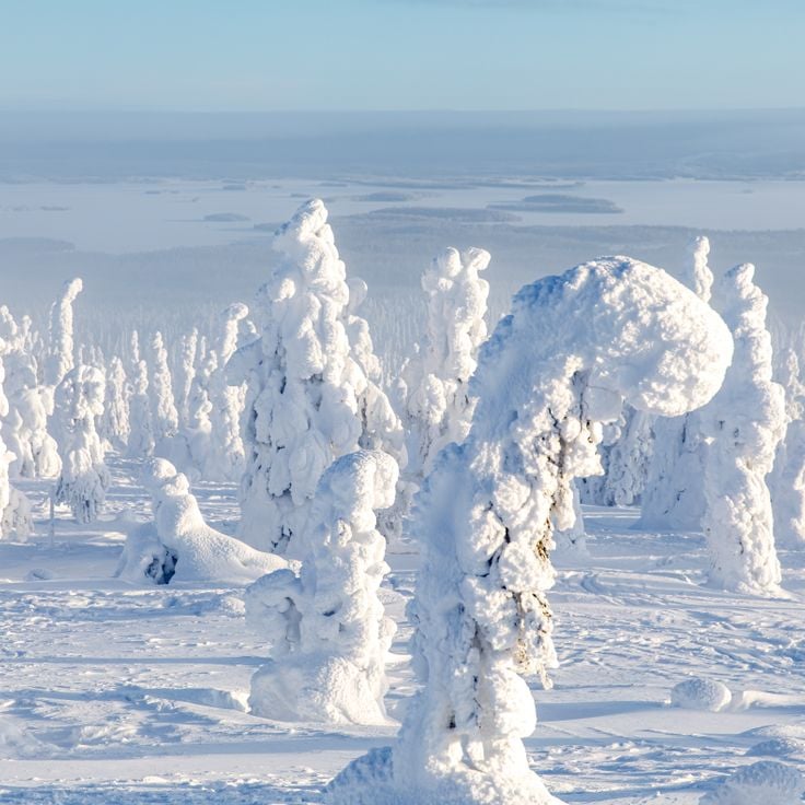
These spruce and pine trees at Riisitunturi National Park accumulate heavy layers of snow and frost during winter months, transforming into white columns known locally as tykky. The buildup forms when moist air masses from the Near East meet arctic cold. The trees maintain this appearance from December through March, with snow coverage sometimes reaching several hundred pounds per tree. The best viewing points lie along hiking trails on the park's fells, where the formations stand visible against open sky.
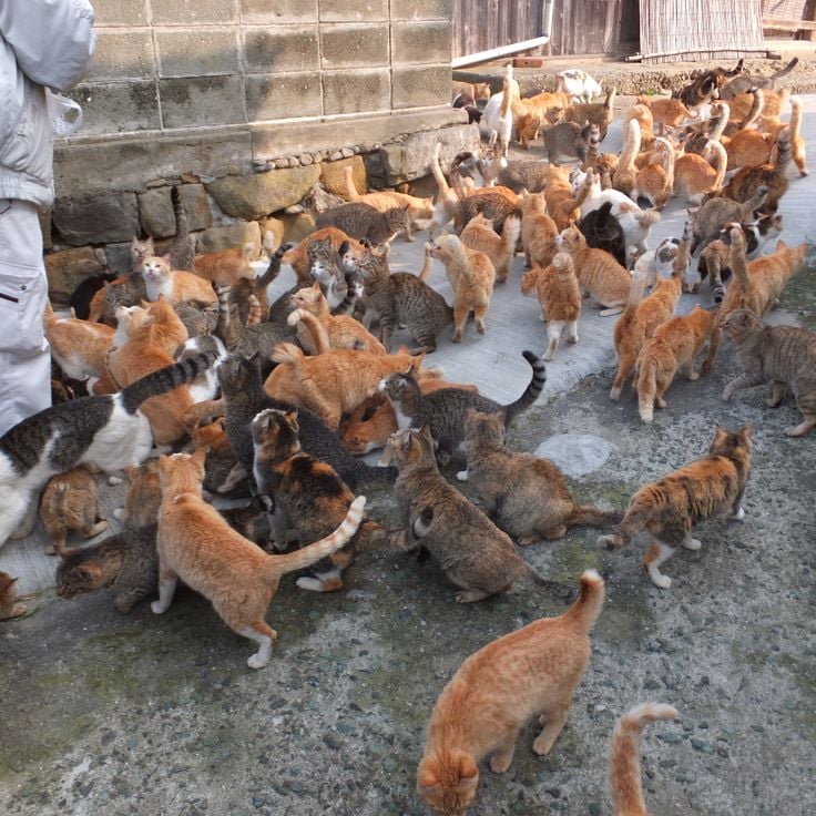
Tashirojima is a small fishing island off Ishinomaki where cats were originally brought in to control mice in silkworm farms. Today the feline population exceeds 100 animals, while the human residents number fewer than 50. The cats roam freely through the settlements and have become the defining feature of this remote community, which represents an unusual example of human-animal cohabitation on a sparsely populated Japanese island.
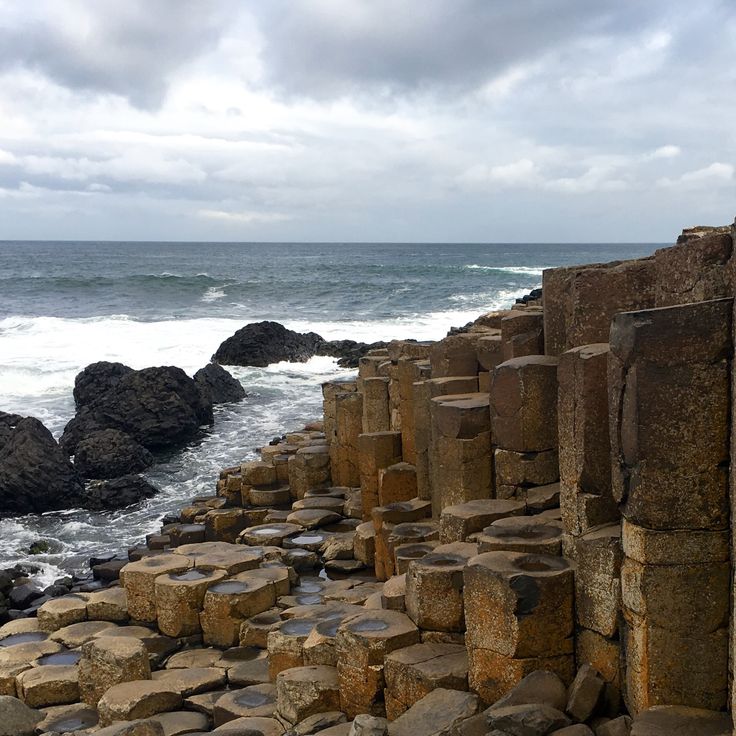
These basalt columns along the Northern Ireland coast formed 60 million years ago through volcanic activity. The site contains approximately 40,000 interlocking stone columns, predominantly hexagonal in shape, with an average diameter of 18 inches (45 centimeters). The geological structure developed as lava cooled and contracted, creating a regular columnar pattern. The basalt formation extends from the cliff edge to the sea, displaying various tiers and platforms. The site demonstrates volcanic processes and rock solidification in a manner significant for geological study. The columns vary in height, with some reaching up to 40 feet (12 meters).
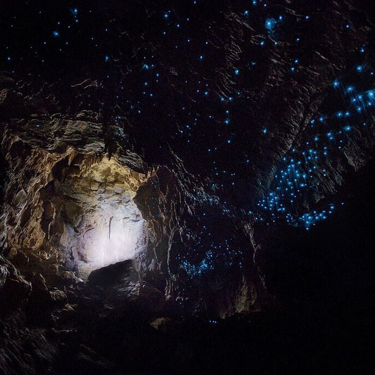
This limestone cave hosts thousands of Arachnocampa luminosa larvae that emit blue light to attract insects. The larvae hang from the ceiling and create a glow resembling a night sky. The formation originated approximately 30 million years ago through marine sediment deposits. Visitors move through the underground Waitomo River by boat while the larvae use bioluminescence to lure prey into sticky threads. The cave sits in the Waitomo District on New Zealand's North Island and belongs to a system of around 300 limestone caves in this region.
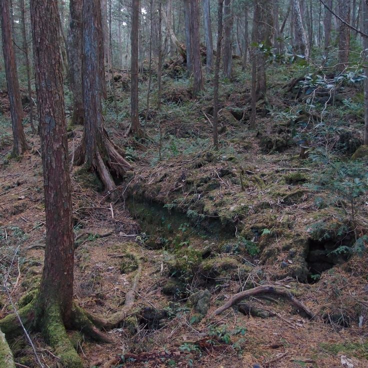
This forest near Mount Fuji covers approximately 14 square miles (35 square kilometers) on volcanic ground formed by an eruption about 1,200 years ago. The lava formations shape the terrain and make walking difficult off marked paths. Dense vegetation of hemlocks, Japanese cypresses and ferns grows on the porous lava base that retains little water. Several designated trails wind through Aokigahara and provide access to ice caves including the Narusawa Ice Cave and Fugaku Wind Cave. The forest sits within Fuji-Hakone-Izu National Park at elevations between 3,300 and 4,300 feet (1,000 and 1,300 meters). The tree canopy filters sunlight and creates a subdued light environment on the forest floor.
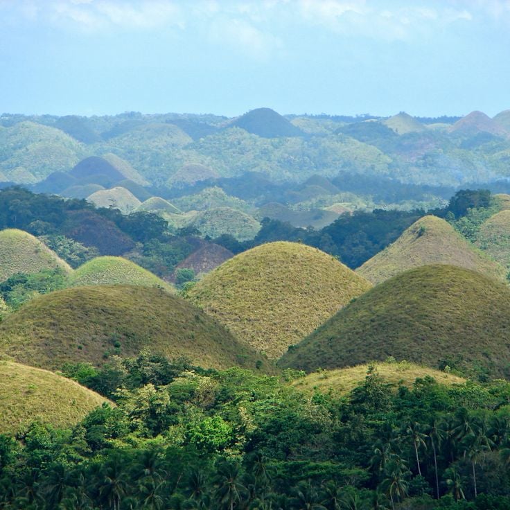
The Chocolate Hills comprise 1,776 symmetrical mounds on Bohol that acquire their characteristic brown color during the dry season. This geological formation covers an area of approximately 20 square miles (50 square kilometers), with individual hills measuring between 98 and 164 feet (30 to 50 meters) in height. The grass covering these limestone formations changes color from green to brown throughout the year, explaining the chocolate reference in their name. Scientists attribute their formation to the weathering of coral deposits that originated millions of years ago.
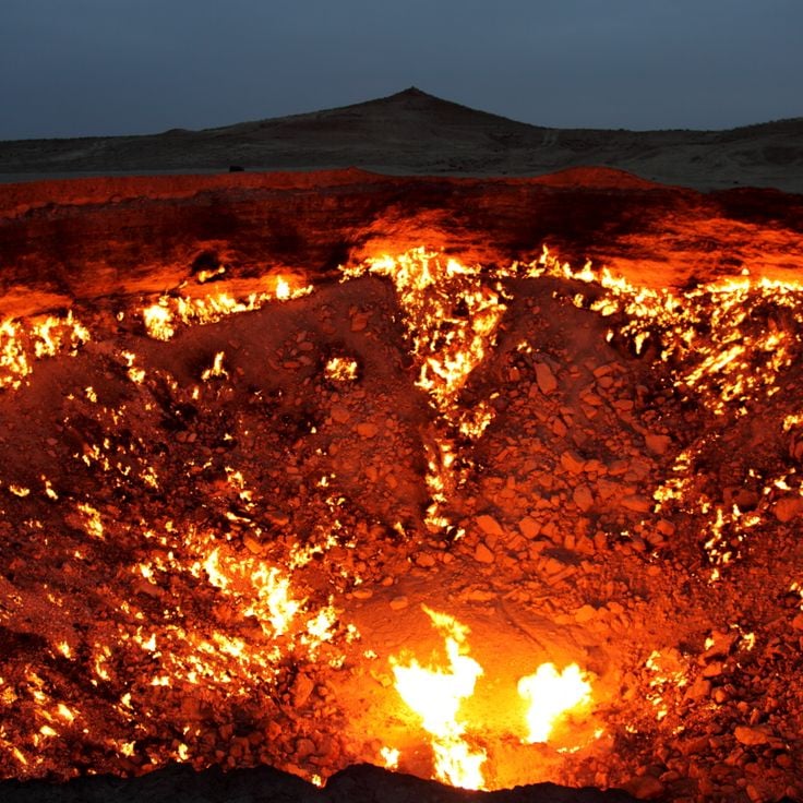
This gas crater measures 230 feet (70 meters) in diameter and has burned continuously since 1971 in the Karakum Desert. The Darvaza Gas Crater formed when a Soviet drilling rig collapsed into an underground natural gas cavern, releasing methane into the air. Geologists ignited the escaping gas to prevent dangerous accumulation, expecting the flames to extinguish within a few weeks. The crater continues burning decades later, giving the site its local name as the Door to Hell. The continuous combustion has shaped a crater with steep walls that glow visibly at night, consuming methane gas from the deposit below. The site demonstrates both geological features of the region and the long-term consequences of industrial exploration activities.
This garden in San Luis Potosí spreads across 80 acres (32 hectares) of tropical rainforest and combines natural waterfalls with manmade structures. Las Pozas was built between 1949 and 1984 by British poet and artist Edward James and consists of more than 30 concrete sculptures and architectural forms that integrate with the surrounding vegetation. The site includes spiral staircases leading nowhere, roofless pavilions, and columned structures set among pools and cascades. The name refers to the natural pools formed by the Arroyo Las Pozas stream that runs through the property.
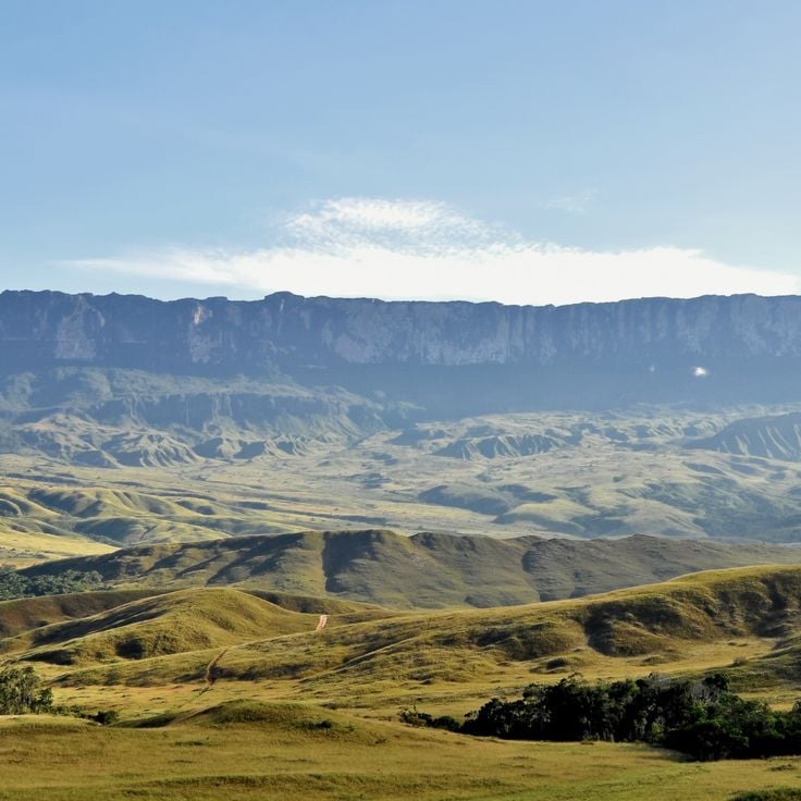
This table mountain in the Guiana Highlands rises to 9,220 feet (2,810 meters) and ranks among Earth's oldest geological formations at approximately 2 billion years old. The flat summit extends across 12 square miles (31 square kilometers) and features sandstone formations shaped by millions of years of erosion. Mount Roraima marks the border between Venezuela, Brazil, and Guyana, its vertical cliff faces reaching up to 1,300 feet (400 meters) in height and displaying the geological record of the Precambrian era.
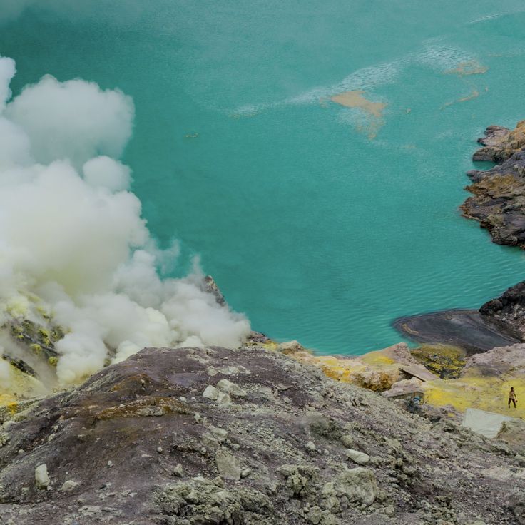
Kawah Ijen holds the largest acid lake on Earth, with a pH of 0.5. At this volcanic crater in East Java, sulfur miners work under extreme conditions near blue flames that burn when sulfurous gases ignite. The turquoise lake contains highly concentrated sulfuric acid and measures roughly 0.6 miles (1 kilometer) across. The blue flames reach heights of up to 16 feet (5 meters) and are visible primarily at night. Sulfur deposits along the crater rim are extracted manually and carried out of the crater. Water temperatures in the lake range between 140 and 194°F (60 and 90°C), and toxic gases rise continuously from the water.
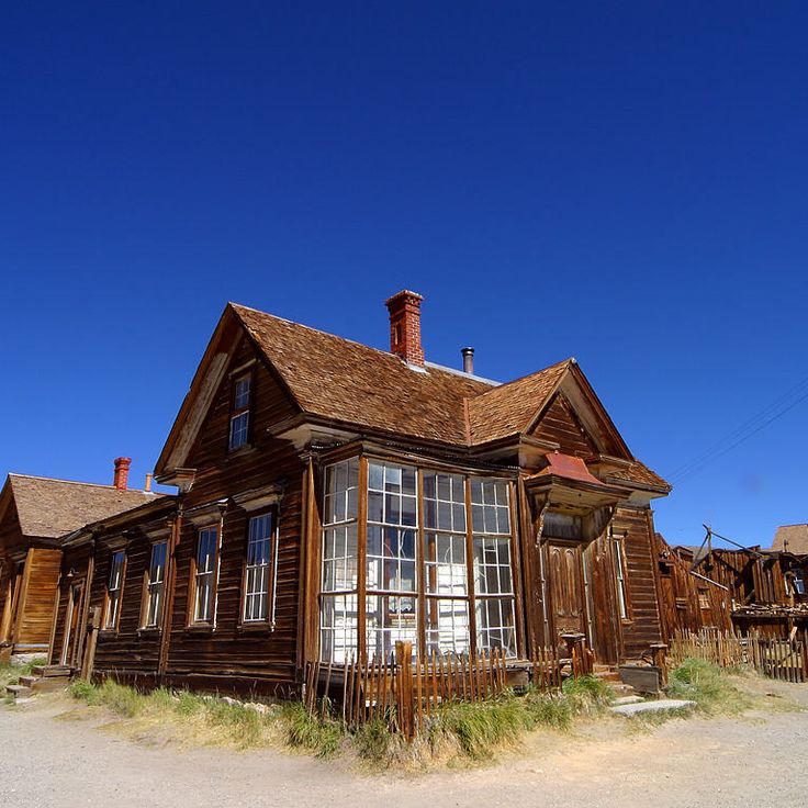
This former gold mining settlement was established in 1876 at an elevation of 8,379 feet (2,554 meters). Bodie Ghost Town represents California's gold rush era with over 100 preserved buildings that remain as they stood when the last residents departed. The structures include homes, stores, saloons, and a church from the period between 1876 and the 1940s. The site covers several square miles in the high desert east of the Sierra Nevada range.
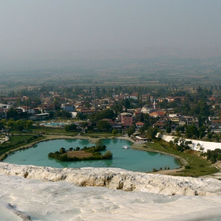
These white travertine terraces extend 8,900 feet (2,700 meters) and form one of the most distinctive geological formations in the region. Pamukkale was shaped by calcium-rich thermal water flowing from springs on the mountainside over thousands of years. The thermal springs maintain a constant temperature of 95 degrees Fahrenheit (35 degrees Celsius). As the water flows down, it deposits calcium carbonate that creates the characteristic white pools and terraces. The site combines natural geological processes with a history of human use dating to ancient times.
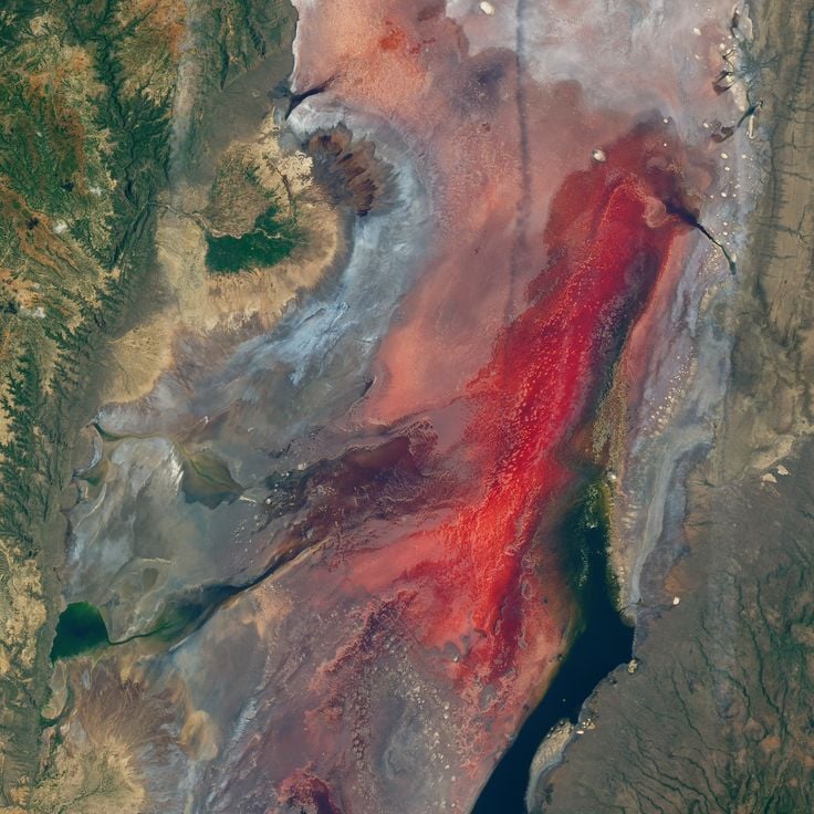
Lake Natron contains high concentrations of sodium carbonate and other mineral salts derived from volcanic activity in the region. The extremely alkaline water reaches pH levels up to 10.5 and can exceed temperatures of 140 degrees Fahrenheit (60 degrees Celsius). Animals that fall into the lake become preserved through the chemical properties of the water, their bodies encrusted with mineral deposits. This lake demonstrates geological processes that can create extreme chemical environments. Flamingos breed regularly at the lake, as they have adapted to these conditions.
This 7.6-meter (25-foot) granite boulder sits balanced on the edge of a mountain cliff in Mon State, entirely covered in gold leaf. Mount Kyaiktiyo ranks among Myanmar's most notable geological and religious sites, with the rock appearing to defy gravity, held in place only by its equilibrium. The structure has served as a Buddhist pilgrimage destination for centuries, and visitors can observe the golden surface up close, created through continuous applications of gold leaf by devotees.
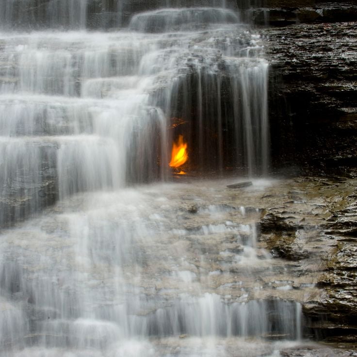
This waterfall in the Shale Creek Preserve demonstrates a geological phenomenon where methane gas seeps through rock fissures and ignites behind the cascading water. The flame burns nearly continuously, though heavy water flow occasionally extinguishes it and requires relighting. The gas originates from natural decomposition processes within the Devonian shale formations beneath the surface. Eternal Flame Falls stands approximately 30 feet (9 meters) high and sits within a forested area south of Buffalo. A hiking trail of roughly half a mile (800 meters) leads from the parking area to the waterfall base. This natural feature combines hydrothermal activity with one of the few accessible natural gas seeps that visitors can observe directly.
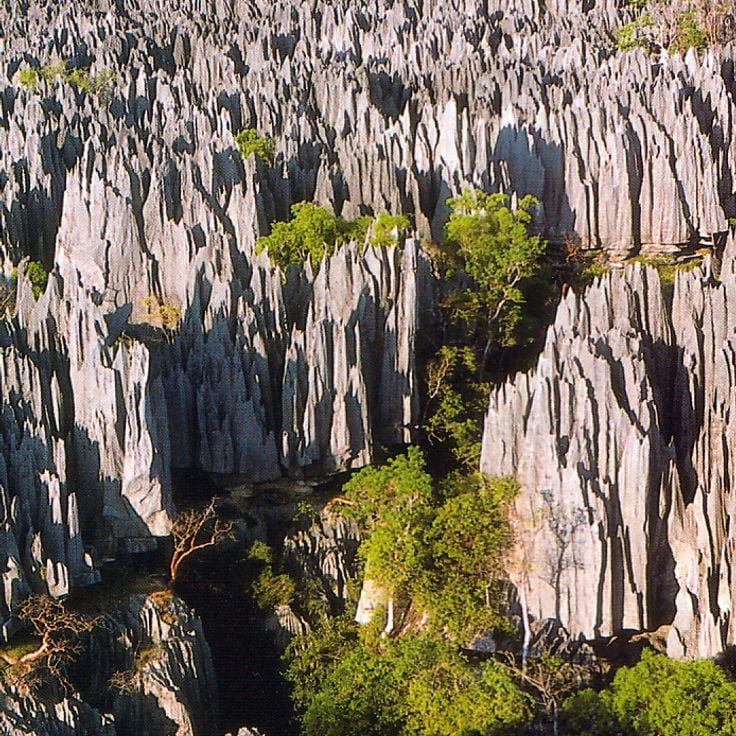
The Tsingy de Bemaraha Strict Nature Reserve features vertical limestone formations that reach heights of 230 feet (70 meters), creating a dense arrangement of sharp stone spires across the landscape. These structures developed over millions of years through erosion and water action on the limestone plateau. The reserve covers 370,000 acres (150,000 hectares) in western Madagascar and supports specialized plant and animal species adapted to the extreme conditions between the limestone needles.
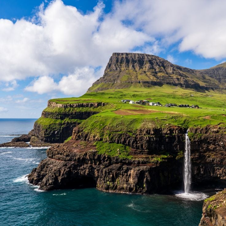
Gásadalur sits at the foot of steep mountains on the western coast of Vágar island. The village remained home to only a handful of residents for much of its history and was accessible solely by a difficult mountain path until a tunnel opened in 2004. A 200-foot (60-meter) waterfall drops from the cliffs directly into the North Atlantic near the settlement. The geographic position between ocean and mountainside makes Gásadalur an example of the settlement patterns found throughout the Faroe Islands.
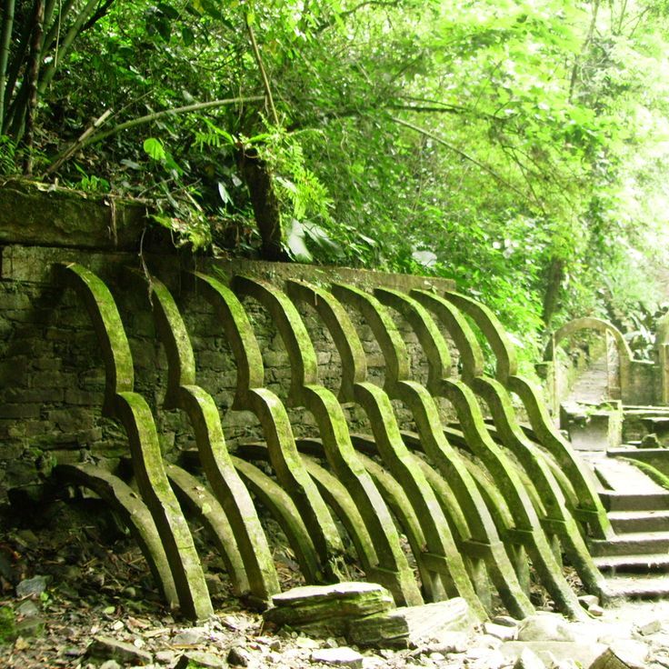
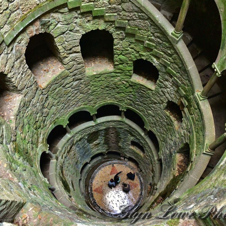
This 27-meter (88-foot) deep shaft at Quinta da Regaleira features a spiral staircase with nine platforms, symbolically representing the circles of Paradise, Purgatory, and Hell from Dante's Divine Comedy. Built in the early 20th century as part of a Masonic estate, the structure descends into an underground tunnel system connecting various areas of the property. Visitors walk down the stone steps carved into the rock face and emerge at the bottom through a stone tunnel leading to the palace gardens. The architectural element illustrates the esoteric philosophy underlying the design of the entire estate.
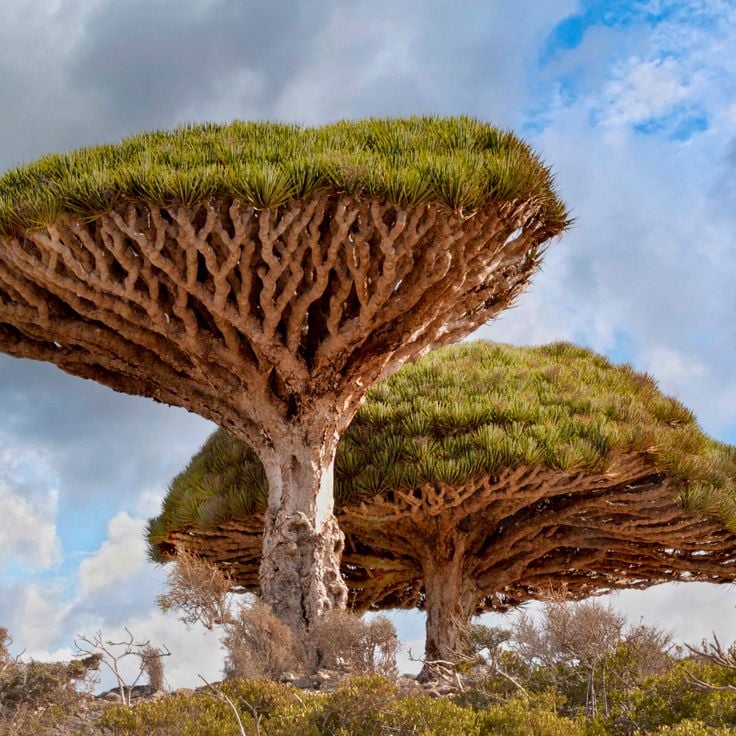
The dragon blood trees of Socotra reach heights of 33 feet (10 meters) and form dense, umbrella-shaped canopies. The red resin of these ancient trees has medicinal properties and was used for centuries as a dye. This botanical feature grows exclusively on the Yemeni island of Socotra and contributes to the geological and biological diversity documented in this collection of exceptional natural sites. The characteristic shape of these trees results from adaptation to the arid climate of the region and enables efficient water collection during the rainy season.
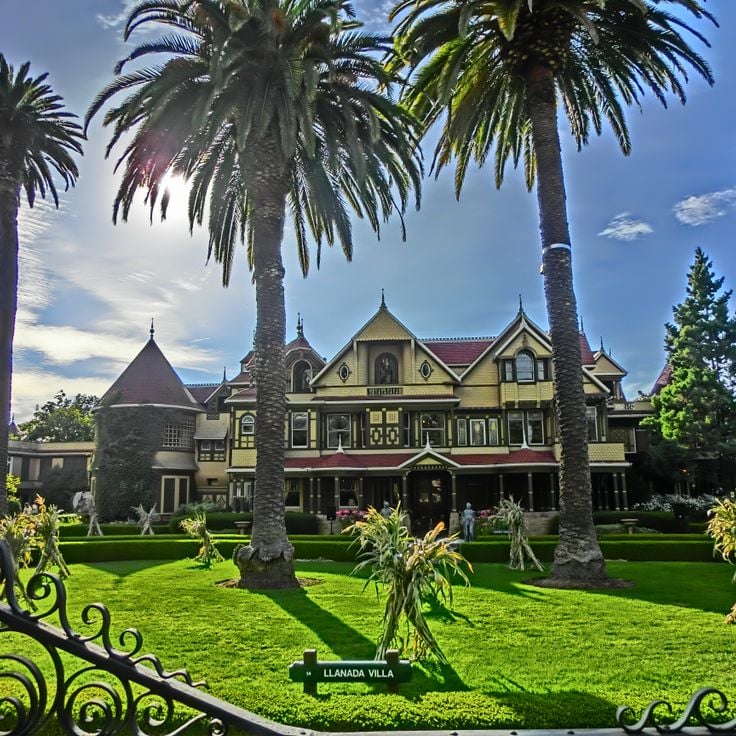
This 160-room estate in California stands among the architectural anomalies that define themselves through exceptional structural features. The Winchester Mystery House contains stairs leading to ceilings, doors opening to walls, and windows overlooking other rooms. Construction extended across 38 years without interruption. The structure demonstrates an unconventional approach to residential architecture and illustrates the diversity of human-made peculiarities.
Fly Geyser formed in 1964 when a geothermal energy company drilled a test well on this site. The escaping mineral-rich water built several mounds over the decades, colored red, green and yellow depending on seasonal conditions and mineral composition. Thermophilic algae growing in the hot springs intensify the coloration. The system sits on private land in the Black Rock Desert and represents one of the more unusual geological formations in Nevada created through human intervention. Water temperatures at the source reach approximately 200 degrees Fahrenheit (93 degrees Celsius), and the mounds continue to grow as minerals accumulate.
This road section in New Brunswick creates an optical illusion where vehicles appear to roll uphill when they are actually moving downhill. The Magnetic Hill uses the topography of the surrounding landscape to distort perception of the slope. Visitors can experience the phenomenon firsthand by placing their vehicle in neutral and watching it seemingly defy gravity. The site belongs to a category of locations worldwide that present similar gravity-defying illusions, demonstrating how landscape features can manipulate spatial perception.
These limestone formations developed from seabed deposits 30 million years ago and acquired their characteristic flat, layered structure through water pressure and seismic activity. The Pancake Rocks represent one of the notable geological features in this collection of exceptional natural phenomena, demonstrating the formative power of natural processes across geological time. At high tide, seawater forces through vertical blowholes and creates fountains that can shoot several meters into the air.
This sandstone formation in Arizona displays red and orange bands created by mineral deposits accumulated over millions of years. Wind and water erosion shaped the undulating lines of the Wave into their current form. The geological feature sits within the Paria Canyon-Vermilion Cliffs Wilderness and requires a desert hike to reach. Access is strictly limited through a lottery system to protect the fragile formation. The layered deposits from the Jurassic period document climatic changes and geological processes in this region of the Colorado Plateau.
This California beach documents the transformation of a former municipal dump site through natural forces. Between 1906 and 1967, Fort Bragg used the area for waste disposal, including large quantities of glass refuse. Pacific wave action ground the discarded glass over decades into small, rounded pebbles of various colors. The site became part of MacKerricher State Park in 2002, and the remaining sea glass continues to diminish through ongoing collection by visitors and natural dispersion.
The Underwater Waterfall off the coast of Mauritius forms through sand and silt deposits that cascade down from the ocean floor, creating an optical illusion. This geological formation in the Indian Ocean demonstrates how underwater currents move sediment along the continental shelf edge, producing a phenomenon that appears from above as cascading water. The deposits flow into deeper waters, forming a dramatic visual effect that illustrates the dynamic nature of marine geology.
This 17th-century Romanian salt mine has been converted into a subterranean leisure complex that combines geological formation with modern entertainment. Salina Turda extends 120 meters (394 feet) below the surface and houses a ferris wheel, sports facilities and an underground lake within the original mining chambers. The mine demonstrates the region's industrial mining heritage while showcasing the adaptation of historical structures for contemporary use. The massive Rudolf Mine chamber, with its exposed salt walls, forms the main atrium of this exceptional facility.
This river in Colombia's Meta Department displays exceptional water coloration between July and November when the endemic red algae Macarenia clavigera grows on the riverbed. The algae carpets create red, yellow, green, blue and black hues in the shallow water over sandstone and quartz formations. The seasonal phenomenon depends on water levels and sunlight exposure that influence algae growth in this tributary of the Guayabero River.
These travertine terraces in Mazandaran Province formed over thousands of years through mineral-rich thermal springs flowing down the slopes of the Zagros Mountains. The distinctive orange and red coloring results from high iron oxide content in the water, which emerges at approximately 104°F (40°C) from two separate springs. Badab-e Surt represents a natural layering system of calcium carbonate and other minerals, with its terraced structure documenting geological processes over an estimated 15,000 years.
This permanent film set for The Lord of the Rings trilogy and The Hobbit films includes 44 hobbit holes built into hillsides in the Waikato region. The site was preserved after filming and displays various sizes of hole entrances to simulate the characters' height differences. Additional structures include a working mill building, detailed gardens with over 300,000 plants, and the Green Dragon Inn, a pub where visitors can stop. The hobbit holes are not accessible inside, but the exterior grounds show the landscaping and architectural techniques used for film production.
Mount Osore is an active volcanic crater in Aomori Prefecture known for its sulfuric emissions and barren terrain. A Buddhist temple at the crater's edge marks this site, which Japanese tradition identifies as an entrance to the afterlife. The sparse landscape, shaped by ongoing volcanic activity, creates an environment that draws both pilgrims and visitors. The Bodaiji Temple serves as the spiritual center, while hot springs and sulfur vents demonstrate the geological characteristics of this mountain.
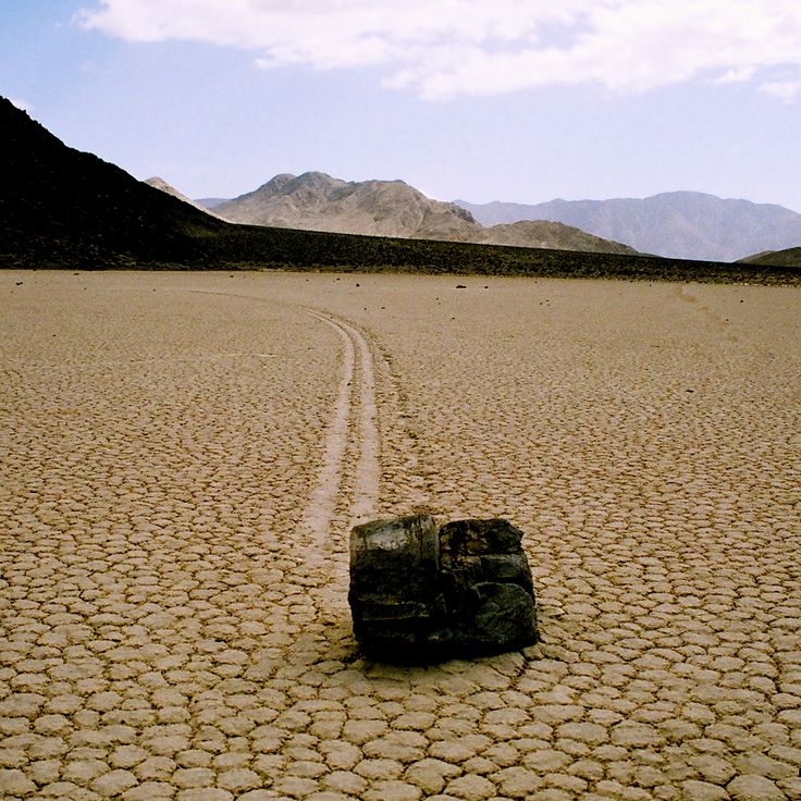
This remote desert basin in Death Valley National Park is known for its moving stones that leave long trails across the dry surface. The rocks, which can weigh up to 700 pounds (320 kilograms), shift through a combination of thin ice sheets, wind, and water. When winter water collects on the playa and freezes overnight, it forms an ice layer that encases the rocks. At sunrise, the ice breaks into large panels that get pushed by wind across the muddy surface, dragging the stones along and creating the distinctive furrows.
These spruce and pine trees at Riisitunturi National Park accumulate heavy layers of snow and frost during winter months, transforming into white columns known locally as tykky. The buildup forms when moist air masses from the Near East meet arctic cold. The trees maintain this appearance from December through March, with snow coverage sometimes reaching several hundred pounds per tree. The best viewing points lie along hiking trails on the park's fells, where the formations stand visible against open sky.
Tashirojima is a small fishing island off Ishinomaki where cats were originally brought in to control mice in silkworm farms. Today the feline population exceeds 100 animals, while the human residents number fewer than 50. The cats roam freely through the settlements and have become the defining feature of this remote community, which represents an unusual example of human-animal cohabitation on a sparsely populated Japanese island.
These basalt columns along the Northern Ireland coast formed 60 million years ago through volcanic activity. The site contains approximately 40,000 interlocking stone columns, predominantly hexagonal in shape, with an average diameter of 18 inches (45 centimeters). The geological structure developed as lava cooled and contracted, creating a regular columnar pattern. The basalt formation extends from the cliff edge to the sea, displaying various tiers and platforms. The site demonstrates volcanic processes and rock solidification in a manner significant for geological study. The columns vary in height, with some reaching up to 40 feet (12 meters).
This limestone cave hosts thousands of Arachnocampa luminosa larvae that emit blue light to attract insects. The larvae hang from the ceiling and create a glow resembling a night sky. The formation originated approximately 30 million years ago through marine sediment deposits. Visitors move through the underground Waitomo River by boat while the larvae use bioluminescence to lure prey into sticky threads. The cave sits in the Waitomo District on New Zealand's North Island and belongs to a system of around 300 limestone caves in this region.
This forest near Mount Fuji covers approximately 14 square miles (35 square kilometers) on volcanic ground formed by an eruption about 1,200 years ago. The lava formations shape the terrain and make walking difficult off marked paths. Dense vegetation of hemlocks, Japanese cypresses and ferns grows on the porous lava base that retains little water. Several designated trails wind through Aokigahara and provide access to ice caves including the Narusawa Ice Cave and Fugaku Wind Cave. The forest sits within Fuji-Hakone-Izu National Park at elevations between 3,300 and 4,300 feet (1,000 and 1,300 meters). The tree canopy filters sunlight and creates a subdued light environment on the forest floor.
The Chocolate Hills comprise 1,776 symmetrical mounds on Bohol that acquire their characteristic brown color during the dry season. This geological formation covers an area of approximately 20 square miles (50 square kilometers), with individual hills measuring between 98 and 164 feet (30 to 50 meters) in height. The grass covering these limestone formations changes color from green to brown throughout the year, explaining the chocolate reference in their name. Scientists attribute their formation to the weathering of coral deposits that originated millions of years ago.
This gas crater measures 230 feet (70 meters) in diameter and has burned continuously since 1971 in the Karakum Desert. The Darvaza Gas Crater formed when a Soviet drilling rig collapsed into an underground natural gas cavern, releasing methane into the air. Geologists ignited the escaping gas to prevent dangerous accumulation, expecting the flames to extinguish within a few weeks. The crater continues burning decades later, giving the site its local name as the Door to Hell. The continuous combustion has shaped a crater with steep walls that glow visibly at night, consuming methane gas from the deposit below. The site demonstrates both geological features of the region and the long-term consequences of industrial exploration activities.
This garden in San Luis Potosí spreads across 80 acres (32 hectares) of tropical rainforest and combines natural waterfalls with manmade structures. Las Pozas was built between 1949 and 1984 by British poet and artist Edward James and consists of more than 30 concrete sculptures and architectural forms that integrate with the surrounding vegetation. The site includes spiral staircases leading nowhere, roofless pavilions, and columned structures set among pools and cascades. The name refers to the natural pools formed by the Arroyo Las Pozas stream that runs through the property.
This table mountain in the Guiana Highlands rises to 9,220 feet (2,810 meters) and ranks among Earth's oldest geological formations at approximately 2 billion years old. The flat summit extends across 12 square miles (31 square kilometers) and features sandstone formations shaped by millions of years of erosion. Mount Roraima marks the border between Venezuela, Brazil, and Guyana, its vertical cliff faces reaching up to 1,300 feet (400 meters) in height and displaying the geological record of the Precambrian era.
Kawah Ijen holds the largest acid lake on Earth, with a pH of 0.5. At this volcanic crater in East Java, sulfur miners work under extreme conditions near blue flames that burn when sulfurous gases ignite. The turquoise lake contains highly concentrated sulfuric acid and measures roughly 0.6 miles (1 kilometer) across. The blue flames reach heights of up to 16 feet (5 meters) and are visible primarily at night. Sulfur deposits along the crater rim are extracted manually and carried out of the crater. Water temperatures in the lake range between 140 and 194°F (60 and 90°C), and toxic gases rise continuously from the water.
This former gold mining settlement was established in 1876 at an elevation of 8,379 feet (2,554 meters). Bodie Ghost Town represents California's gold rush era with over 100 preserved buildings that remain as they stood when the last residents departed. The structures include homes, stores, saloons, and a church from the period between 1876 and the 1940s. The site covers several square miles in the high desert east of the Sierra Nevada range.
These white travertine terraces extend 8,900 feet (2,700 meters) and form one of the most distinctive geological formations in the region. Pamukkale was shaped by calcium-rich thermal water flowing from springs on the mountainside over thousands of years. The thermal springs maintain a constant temperature of 95 degrees Fahrenheit (35 degrees Celsius). As the water flows down, it deposits calcium carbonate that creates the characteristic white pools and terraces. The site combines natural geological processes with a history of human use dating to ancient times.
Lake Natron contains high concentrations of sodium carbonate and other mineral salts derived from volcanic activity in the region. The extremely alkaline water reaches pH levels up to 10.5 and can exceed temperatures of 140 degrees Fahrenheit (60 degrees Celsius). Animals that fall into the lake become preserved through the chemical properties of the water, their bodies encrusted with mineral deposits. This lake demonstrates geological processes that can create extreme chemical environments. Flamingos breed regularly at the lake, as they have adapted to these conditions.
This 7.6-meter (25-foot) granite boulder sits balanced on the edge of a mountain cliff in Mon State, entirely covered in gold leaf. Mount Kyaiktiyo ranks among Myanmar's most notable geological and religious sites, with the rock appearing to defy gravity, held in place only by its equilibrium. The structure has served as a Buddhist pilgrimage destination for centuries, and visitors can observe the golden surface up close, created through continuous applications of gold leaf by devotees.
This waterfall in the Shale Creek Preserve demonstrates a geological phenomenon where methane gas seeps through rock fissures and ignites behind the cascading water. The flame burns nearly continuously, though heavy water flow occasionally extinguishes it and requires relighting. The gas originates from natural decomposition processes within the Devonian shale formations beneath the surface. Eternal Flame Falls stands approximately 30 feet (9 meters) high and sits within a forested area south of Buffalo. A hiking trail of roughly half a mile (800 meters) leads from the parking area to the waterfall base. This natural feature combines hydrothermal activity with one of the few accessible natural gas seeps that visitors can observe directly.
The Tsingy de Bemaraha Strict Nature Reserve features vertical limestone formations that reach heights of 230 feet (70 meters), creating a dense arrangement of sharp stone spires across the landscape. These structures developed over millions of years through erosion and water action on the limestone plateau. The reserve covers 370,000 acres (150,000 hectares) in western Madagascar and supports specialized plant and animal species adapted to the extreme conditions between the limestone needles.
Gásadalur sits at the foot of steep mountains on the western coast of Vágar island. The village remained home to only a handful of residents for much of its history and was accessible solely by a difficult mountain path until a tunnel opened in 2004. A 200-foot (60-meter) waterfall drops from the cliffs directly into the North Atlantic near the settlement. The geographic position between ocean and mountainside makes Gásadalur an example of the settlement patterns found throughout the Faroe Islands.
This 27-meter (88-foot) deep shaft at Quinta da Regaleira features a spiral staircase with nine platforms, symbolically representing the circles of Paradise, Purgatory, and Hell from Dante's Divine Comedy. Built in the early 20th century as part of a Masonic estate, the structure descends into an underground tunnel system connecting various areas of the property. Visitors walk down the stone steps carved into the rock face and emerge at the bottom through a stone tunnel leading to the palace gardens. The architectural element illustrates the esoteric philosophy underlying the design of the entire estate.
The dragon blood trees of Socotra reach heights of 33 feet (10 meters) and form dense, umbrella-shaped canopies. The red resin of these ancient trees has medicinal properties and was used for centuries as a dye. This botanical feature grows exclusively on the Yemeni island of Socotra and contributes to the geological and biological diversity documented in this collection of exceptional natural sites. The characteristic shape of these trees results from adaptation to the arid climate of the region and enables efficient water collection during the rainy season.
This 160-room estate in California stands among the architectural anomalies that define themselves through exceptional structural features. The Winchester Mystery House contains stairs leading to ceilings, doors opening to walls, and windows overlooking other rooms. Construction extended across 38 years without interruption. The structure demonstrates an unconventional approach to residential architecture and illustrates the diversity of human-made peculiarities.
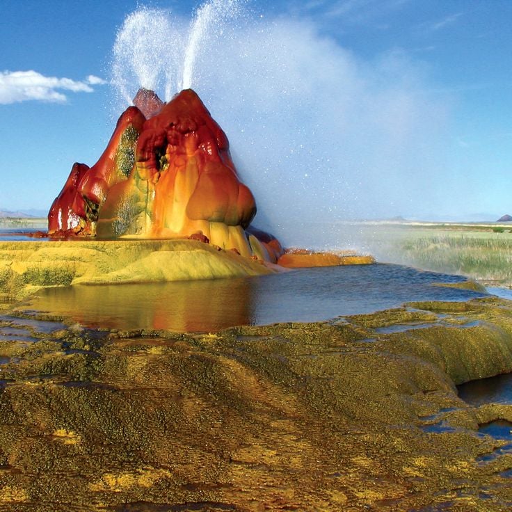
Fly Geyser formed in 1964 when a geothermal energy company drilled a test well on this site. The escaping mineral-rich water built several mounds over the decades, colored red, green and yellow depending on seasonal conditions and mineral composition. Thermophilic algae growing in the hot springs intensify the coloration. The system sits on private land in the Black Rock Desert and represents one of the more unusual geological formations in Nevada created through human intervention. Water temperatures at the source reach approximately 200 degrees Fahrenheit (93 degrees Celsius), and the mounds continue to grow as minerals accumulate.
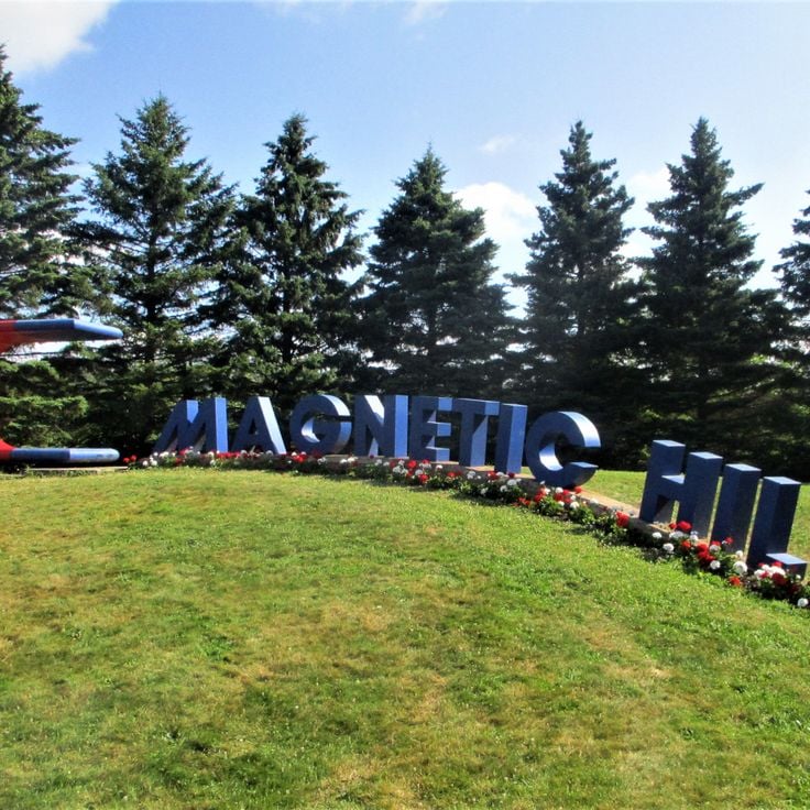
This road section in New Brunswick creates an optical illusion where vehicles appear to roll uphill when they are actually moving downhill. The Magnetic Hill uses the topography of the surrounding landscape to distort perception of the slope. Visitors can experience the phenomenon firsthand by placing their vehicle in neutral and watching it seemingly defy gravity. The site belongs to a category of locations worldwide that present similar gravity-defying illusions, demonstrating how landscape features can manipulate spatial perception.
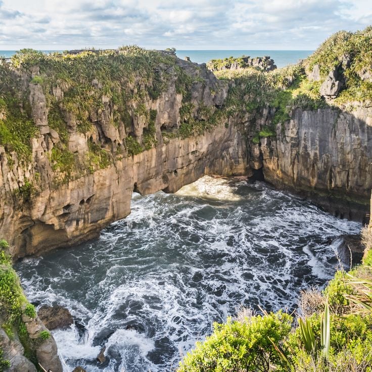
These limestone formations developed from seabed deposits 30 million years ago and acquired their characteristic flat, layered structure through water pressure and seismic activity. The Pancake Rocks represent one of the notable geological features in this collection of exceptional natural phenomena, demonstrating the formative power of natural processes across geological time. At high tide, seawater forces through vertical blowholes and creates fountains that can shoot several meters into the air.
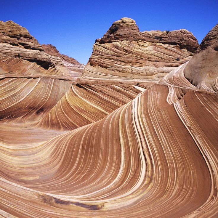
This sandstone formation in Arizona displays red and orange bands created by mineral deposits accumulated over millions of years. Wind and water erosion shaped the undulating lines of the Wave into their current form. The geological feature sits within the Paria Canyon-Vermilion Cliffs Wilderness and requires a desert hike to reach. Access is strictly limited through a lottery system to protect the fragile formation. The layered deposits from the Jurassic period document climatic changes and geological processes in this region of the Colorado Plateau.
This California beach documents the transformation of a former municipal dump site through natural forces. Between 1906 and 1967, Fort Bragg used the area for waste disposal, including large quantities of glass refuse. Pacific wave action ground the discarded glass over decades into small, rounded pebbles of various colors. The site became part of MacKerricher State Park in 2002, and the remaining sea glass continues to diminish through ongoing collection by visitors and natural dispersion.
The Underwater Waterfall off the coast of Mauritius forms through sand and silt deposits that cascade down from the ocean floor, creating an optical illusion. This geological formation in the Indian Ocean demonstrates how underwater currents move sediment along the continental shelf edge, producing a phenomenon that appears from above as cascading water. The deposits flow into deeper waters, forming a dramatic visual effect that illustrates the dynamic nature of marine geology.
This 17th-century Romanian salt mine has been converted into a subterranean leisure complex that combines geological formation with modern entertainment. Salina Turda extends 120 meters (394 feet) below the surface and houses a ferris wheel, sports facilities and an underground lake within the original mining chambers. The mine demonstrates the region's industrial mining heritage while showcasing the adaptation of historical structures for contemporary use. The massive Rudolf Mine chamber, with its exposed salt walls, forms the main atrium of this exceptional facility.
This river in Colombia's Meta Department displays exceptional water coloration between July and November when the endemic red algae Macarenia clavigera grows on the riverbed. The algae carpets create red, yellow, green, blue and black hues in the shallow water over sandstone and quartz formations. The seasonal phenomenon depends on water levels and sunlight exposure that influence algae growth in this tributary of the Guayabero River.
These travertine terraces in Mazandaran Province formed over thousands of years through mineral-rich thermal springs flowing down the slopes of the Zagros Mountains. The distinctive orange and red coloring results from high iron oxide content in the water, which emerges at approximately 104°F (40°C) from two separate springs. Badab-e Surt represents a natural layering system of calcium carbonate and other minerals, with its terraced structure documenting geological processes over an estimated 15,000 years.
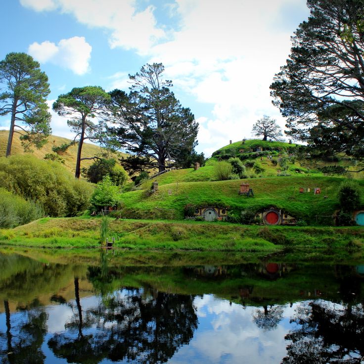
This permanent film set for The Lord of the Rings trilogy and The Hobbit films includes 44 hobbit holes built into hillsides in the Waikato region. The site was preserved after filming and displays various sizes of hole entrances to simulate the characters' height differences. Additional structures include a working mill building, detailed gardens with over 300,000 plants, and the Green Dragon Inn, a pub where visitors can stop. The hobbit holes are not accessible inside, but the exterior grounds show the landscaping and architectural techniques used for film production.
Mount Osore is an active volcanic crater in Aomori Prefecture known for its sulfuric emissions and barren terrain. A Buddhist temple at the crater's edge marks this site, which Japanese tradition identifies as an entrance to the afterlife. The sparse landscape, shaped by ongoing volcanic activity, creates an environment that draws both pilgrims and visitors. The Bodaiji Temple serves as the spiritual center, while hot springs and sulfur vents demonstrate the geological characteristics of this mountain.
This remote desert basin in Death Valley National Park is known for its moving stones that leave long trails across the dry surface. The rocks, which can weigh up to 700 pounds (320 kilograms), shift through a combination of thin ice sheets, wind, and water. When winter water collects on the playa and freezes overnight, it forms an ice layer that encases the rocks. At sunrise, the ice breaks into large panels that get pushed by wind across the muddy surface, dragging the stones along and creating the distinctive furrows.
These spruce and pine trees at Riisitunturi National Park accumulate heavy layers of snow and frost during winter months, transforming into white columns known locally as tykky. The buildup forms when moist air masses from the Near East meet arctic cold. The trees maintain this appearance from December through March, with snow coverage sometimes reaching several hundred pounds per tree. The best viewing points lie along hiking trails on the park's fells, where the formations stand visible against open sky.
Tashirojima is a small fishing island off Ishinomaki where cats were originally brought in to control mice in silkworm farms. Today the feline population exceeds 100 animals, while the human residents number fewer than 50. The cats roam freely through the settlements and have become the defining feature of this remote community, which represents an unusual example of human-animal cohabitation on a sparsely populated Japanese island.
These basalt columns along the Northern Ireland coast formed 60 million years ago through volcanic activity. The site contains approximately 40,000 interlocking stone columns, predominantly hexagonal in shape, with an average diameter of 18 inches (45 centimeters). The geological structure developed as lava cooled and contracted, creating a regular columnar pattern. The basalt formation extends from the cliff edge to the sea, displaying various tiers and platforms. The site demonstrates volcanic processes and rock solidification in a manner significant for geological study. The columns vary in height, with some reaching up to 40 feet (12 meters).
This limestone cave hosts thousands of Arachnocampa luminosa larvae that emit blue light to attract insects. The larvae hang from the ceiling and create a glow resembling a night sky. The formation originated approximately 30 million years ago through marine sediment deposits. Visitors move through the underground Waitomo River by boat while the larvae use bioluminescence to lure prey into sticky threads. The cave sits in the Waitomo District on New Zealand's North Island and belongs to a system of around 300 limestone caves in this region.
This forest near Mount Fuji covers approximately 14 square miles (35 square kilometers) on volcanic ground formed by an eruption about 1,200 years ago. The lava formations shape the terrain and make walking difficult off marked paths. Dense vegetation of hemlocks, Japanese cypresses and ferns grows on the porous lava base that retains little water. Several designated trails wind through Aokigahara and provide access to ice caves including the Narusawa Ice Cave and Fugaku Wind Cave. The forest sits within Fuji-Hakone-Izu National Park at elevations between 3,300 and 4,300 feet (1,000 and 1,300 meters). The tree canopy filters sunlight and creates a subdued light environment on the forest floor.
The Chocolate Hills comprise 1,776 symmetrical mounds on Bohol that acquire their characteristic brown color during the dry season. This geological formation covers an area of approximately 20 square miles (50 square kilometers), with individual hills measuring between 98 and 164 feet (30 to 50 meters) in height. The grass covering these limestone formations changes color from green to brown throughout the year, explaining the chocolate reference in their name. Scientists attribute their formation to the weathering of coral deposits that originated millions of years ago.
This gas crater measures 230 feet (70 meters) in diameter and has burned continuously since 1971 in the Karakum Desert. The Darvaza Gas Crater formed when a Soviet drilling rig collapsed into an underground natural gas cavern, releasing methane into the air. Geologists ignited the escaping gas to prevent dangerous accumulation, expecting the flames to extinguish within a few weeks. The crater continues burning decades later, giving the site its local name as the Door to Hell. The continuous combustion has shaped a crater with steep walls that glow visibly at night, consuming methane gas from the deposit below. The site demonstrates both geological features of the region and the long-term consequences of industrial exploration activities.
This garden in San Luis Potosí spreads across 80 acres (32 hectares) of tropical rainforest and combines natural waterfalls with manmade structures. Las Pozas was built between 1949 and 1984 by British poet and artist Edward James and consists of more than 30 concrete sculptures and architectural forms that integrate with the surrounding vegetation. The site includes spiral staircases leading nowhere, roofless pavilions, and columned structures set among pools and cascades. The name refers to the natural pools formed by the Arroyo Las Pozas stream that runs through the property.
This table mountain in the Guiana Highlands rises to 9,220 feet (2,810 meters) and ranks among Earth's oldest geological formations at approximately 2 billion years old. The flat summit extends across 12 square miles (31 square kilometers) and features sandstone formations shaped by millions of years of erosion. Mount Roraima marks the border between Venezuela, Brazil, and Guyana, its vertical cliff faces reaching up to 1,300 feet (400 meters) in height and displaying the geological record of the Precambrian era.
Kawah Ijen holds the largest acid lake on Earth, with a pH of 0.5. At this volcanic crater in East Java, sulfur miners work under extreme conditions near blue flames that burn when sulfurous gases ignite. The turquoise lake contains highly concentrated sulfuric acid and measures roughly 0.6 miles (1 kilometer) across. The blue flames reach heights of up to 16 feet (5 meters) and are visible primarily at night. Sulfur deposits along the crater rim are extracted manually and carried out of the crater. Water temperatures in the lake range between 140 and 194°F (60 and 90°C), and toxic gases rise continuously from the water.
This former gold mining settlement was established in 1876 at an elevation of 8,379 feet (2,554 meters). Bodie Ghost Town represents California's gold rush era with over 100 preserved buildings that remain as they stood when the last residents departed. The structures include homes, stores, saloons, and a church from the period between 1876 and the 1940s. The site covers several square miles in the high desert east of the Sierra Nevada range.
These white travertine terraces extend 8,900 feet (2,700 meters) and form one of the most distinctive geological formations in the region. Pamukkale was shaped by calcium-rich thermal water flowing from springs on the mountainside over thousands of years. The thermal springs maintain a constant temperature of 95 degrees Fahrenheit (35 degrees Celsius). As the water flows down, it deposits calcium carbonate that creates the characteristic white pools and terraces. The site combines natural geological processes with a history of human use dating to ancient times.
Lake Natron contains high concentrations of sodium carbonate and other mineral salts derived from volcanic activity in the region. The extremely alkaline water reaches pH levels up to 10.5 and can exceed temperatures of 140 degrees Fahrenheit (60 degrees Celsius). Animals that fall into the lake become preserved through the chemical properties of the water, their bodies encrusted with mineral deposits. This lake demonstrates geological processes that can create extreme chemical environments. Flamingos breed regularly at the lake, as they have adapted to these conditions.
This 7.6-meter (25-foot) granite boulder sits balanced on the edge of a mountain cliff in Mon State, entirely covered in gold leaf. Mount Kyaiktiyo ranks among Myanmar's most notable geological and religious sites, with the rock appearing to defy gravity, held in place only by its equilibrium. The structure has served as a Buddhist pilgrimage destination for centuries, and visitors can observe the golden surface up close, created through continuous applications of gold leaf by devotees.
This waterfall in the Shale Creek Preserve demonstrates a geological phenomenon where methane gas seeps through rock fissures and ignites behind the cascading water. The flame burns nearly continuously, though heavy water flow occasionally extinguishes it and requires relighting. The gas originates from natural decomposition processes within the Devonian shale formations beneath the surface. Eternal Flame Falls stands approximately 30 feet (9 meters) high and sits within a forested area south of Buffalo. A hiking trail of roughly half a mile (800 meters) leads from the parking area to the waterfall base. This natural feature combines hydrothermal activity with one of the few accessible natural gas seeps that visitors can observe directly.
The Tsingy de Bemaraha Strict Nature Reserve features vertical limestone formations that reach heights of 230 feet (70 meters), creating a dense arrangement of sharp stone spires across the landscape. These structures developed over millions of years through erosion and water action on the limestone plateau. The reserve covers 370,000 acres (150,000 hectares) in western Madagascar and supports specialized plant and animal species adapted to the extreme conditions between the limestone needles.
Gásadalur sits at the foot of steep mountains on the western coast of Vágar island. The village remained home to only a handful of residents for much of its history and was accessible solely by a difficult mountain path until a tunnel opened in 2004. A 200-foot (60-meter) waterfall drops from the cliffs directly into the North Atlantic near the settlement. The geographic position between ocean and mountainside makes Gásadalur an example of the settlement patterns found throughout the Faroe Islands.
This 27-meter (88-foot) deep shaft at Quinta da Regaleira features a spiral staircase with nine platforms, symbolically representing the circles of Paradise, Purgatory, and Hell from Dante's Divine Comedy. Built in the early 20th century as part of a Masonic estate, the structure descends into an underground tunnel system connecting various areas of the property. Visitors walk down the stone steps carved into the rock face and emerge at the bottom through a stone tunnel leading to the palace gardens. The architectural element illustrates the esoteric philosophy underlying the design of the entire estate.
The dragon blood trees of Socotra reach heights of 33 feet (10 meters) and form dense, umbrella-shaped canopies. The red resin of these ancient trees has medicinal properties and was used for centuries as a dye. This botanical feature grows exclusively on the Yemeni island of Socotra and contributes to the geological and biological diversity documented in this collection of exceptional natural sites. The characteristic shape of these trees results from adaptation to the arid climate of the region and enables efficient water collection during the rainy season.
This 160-room estate in California stands among the architectural anomalies that define themselves through exceptional structural features. The Winchester Mystery House contains stairs leading to ceilings, doors opening to walls, and windows overlooking other rooms. Construction extended across 38 years without interruption. The structure demonstrates an unconventional approach to residential architecture and illustrates the diversity of human-made peculiarities.
Fly Geyser formed in 1964 when a geothermal energy company drilled a test well on this site. The escaping mineral-rich water built several mounds over the decades, colored red, green and yellow depending on seasonal conditions and mineral composition. Thermophilic algae growing in the hot springs intensify the coloration. The system sits on private land in the Black Rock Desert and represents one of the more unusual geological formations in Nevada created through human intervention. Water temperatures at the source reach approximately 200 degrees Fahrenheit (93 degrees Celsius), and the mounds continue to grow as minerals accumulate.
This road section in New Brunswick creates an optical illusion where vehicles appear to roll uphill when they are actually moving downhill. The Magnetic Hill uses the topography of the surrounding landscape to distort perception of the slope. Visitors can experience the phenomenon firsthand by placing their vehicle in neutral and watching it seemingly defy gravity. The site belongs to a category of locations worldwide that present similar gravity-defying illusions, demonstrating how landscape features can manipulate spatial perception.
These limestone formations developed from seabed deposits 30 million years ago and acquired their characteristic flat, layered structure through water pressure and seismic activity. The Pancake Rocks represent one of the notable geological features in this collection of exceptional natural phenomena, demonstrating the formative power of natural processes across geological time. At high tide, seawater forces through vertical blowholes and creates fountains that can shoot several meters into the air.
This sandstone formation in Arizona displays red and orange bands created by mineral deposits accumulated over millions of years. Wind and water erosion shaped the undulating lines of the Wave into their current form. The geological feature sits within the Paria Canyon-Vermilion Cliffs Wilderness and requires a desert hike to reach. Access is strictly limited through a lottery system to protect the fragile formation. The layered deposits from the Jurassic period document climatic changes and geological processes in this region of the Colorado Plateau.
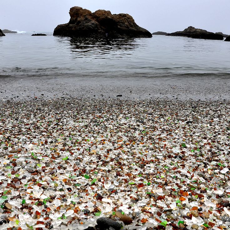
This California beach documents the transformation of a former municipal dump site through natural forces. Between 1906 and 1967, Fort Bragg used the area for waste disposal, including large quantities of glass refuse. Pacific wave action ground the discarded glass over decades into small, rounded pebbles of various colors. The site became part of MacKerricher State Park in 2002, and the remaining sea glass continues to diminish through ongoing collection by visitors and natural dispersion.
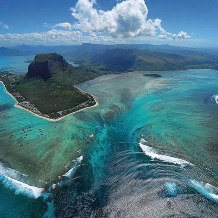
The Underwater Waterfall off the coast of Mauritius forms through sand and silt deposits that cascade down from the ocean floor, creating an optical illusion. This geological formation in the Indian Ocean demonstrates how underwater currents move sediment along the continental shelf edge, producing a phenomenon that appears from above as cascading water. The deposits flow into deeper waters, forming a dramatic visual effect that illustrates the dynamic nature of marine geology.
This 17th-century Romanian salt mine has been converted into a subterranean leisure complex that combines geological formation with modern entertainment. Salina Turda extends 120 meters (394 feet) below the surface and houses a ferris wheel, sports facilities and an underground lake within the original mining chambers. The mine demonstrates the region's industrial mining heritage while showcasing the adaptation of historical structures for contemporary use. The massive Rudolf Mine chamber, with its exposed salt walls, forms the main atrium of this exceptional facility.
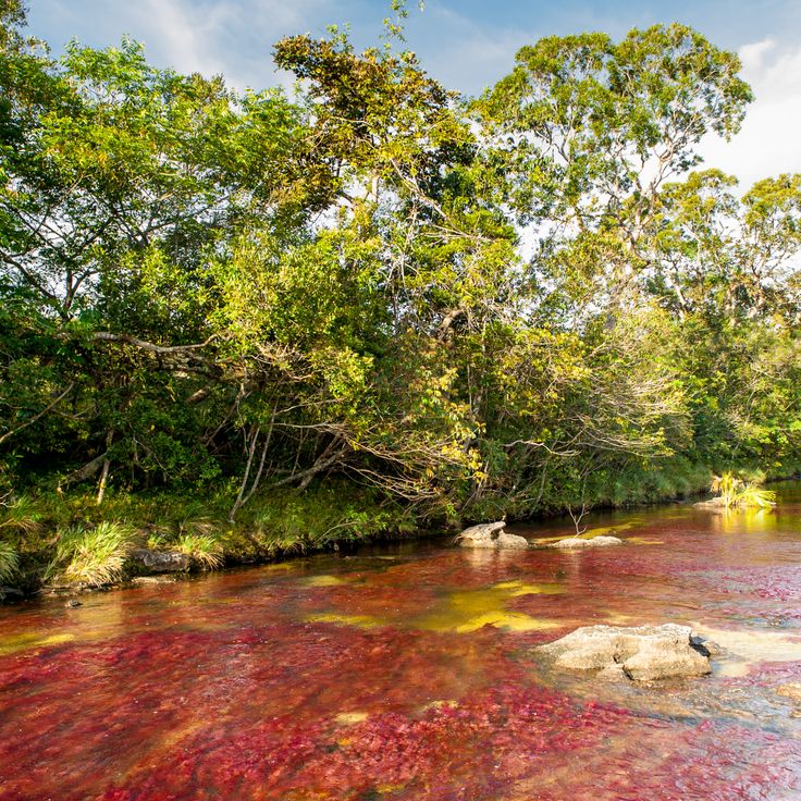
This river in Colombia's Meta Department displays exceptional water coloration between July and November when the endemic red algae Macarenia clavigera grows on the riverbed. The algae carpets create red, yellow, green, blue and black hues in the shallow water over sandstone and quartz formations. The seasonal phenomenon depends on water levels and sunlight exposure that influence algae growth in this tributary of the Guayabero River.
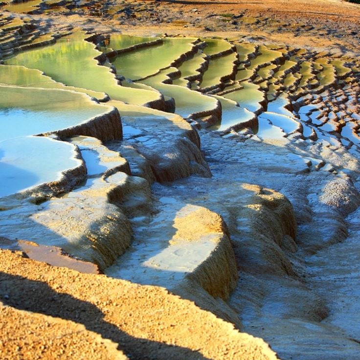
These travertine terraces in Mazandaran Province formed over thousands of years through mineral-rich thermal springs flowing down the slopes of the Zagros Mountains. The distinctive orange and red coloring results from high iron oxide content in the water, which emerges at approximately 104°F (40°C) from two separate springs. Badab-e Surt represents a natural layering system of calcium carbonate and other minerals, with its terraced structure documenting geological processes over an estimated 15,000 years.
This permanent film set for The Lord of the Rings trilogy and The Hobbit films includes 44 hobbit holes built into hillsides in the Waikato region. The site was preserved after filming and displays various sizes of hole entrances to simulate the characters' height differences. Additional structures include a working mill building, detailed gardens with over 300,000 plants, and the Green Dragon Inn, a pub where visitors can stop. The hobbit holes are not accessible inside, but the exterior grounds show the landscaping and architectural techniques used for film production.
Mount Osore is an active volcanic crater in Aomori Prefecture known for its sulfuric emissions and barren terrain. A Buddhist temple at the crater's edge marks this site, which Japanese tradition identifies as an entrance to the afterlife. The sparse landscape, shaped by ongoing volcanic activity, creates an environment that draws both pilgrims and visitors. The Bodaiji Temple serves as the spiritual center, while hot springs and sulfur vents demonstrate the geological characteristics of this mountain.
This remote desert basin in Death Valley National Park is known for its moving stones that leave long trails across the dry surface. The rocks, which can weigh up to 700 pounds (320 kilograms), shift through a combination of thin ice sheets, wind, and water. When winter water collects on the playa and freezes overnight, it forms an ice layer that encases the rocks. At sunrise, the ice breaks into large panels that get pushed by wind across the muddy surface, dragging the stones along and creating the distinctive furrows.