See the monuments around you in AROpen chests in the app
Around Us is built for your phone — point your camera at the streets and discover the monuments and places around you in augmented reality.Around Us is built for your phone — chests unlock when you walk, explore and capture nearby places.
Unusual natural wonders and geological formations worldwide
This collection presents extraordinary natural phenomena and geological formations across all continents, from salt flats and volcanic crater fields to underground cave systems and landscapes shaped by mineral deposits. The featured sites display rare geological processes: moving stones leave mysterious tracks across California desert playas, methane gas feeds flames in a Turkmenistan crater for decades, and thermal springs create white travertine terraces in the Turkish countryside. Coral reefs form circular structures off the coast of Belize, while chemical reactions turn lakes pink in Australia and rivers brilliant colors in Colombia.
The geological features include hexagonal basalt columns along the Northern Irish coast, conical limestone hills on Philippine islands, and mushroom shaped sandstone formations in Utah. Caves in New Zealand house thousands of bioluminescent larvae, while one of the world's largest caverns lies beneath Vietnamese mountains. Locations range from a geyser studded desert basin in Nevada to red algae carpets along Chinese shores to isolated islands off the Yemeni coast with endemic flora. This collection encompasses both ancient archaeological puzzles like stone jars in Laos and ground drawings in Peru, as well as natural optical illusions such as apparent underwater cascades off Mauritius.
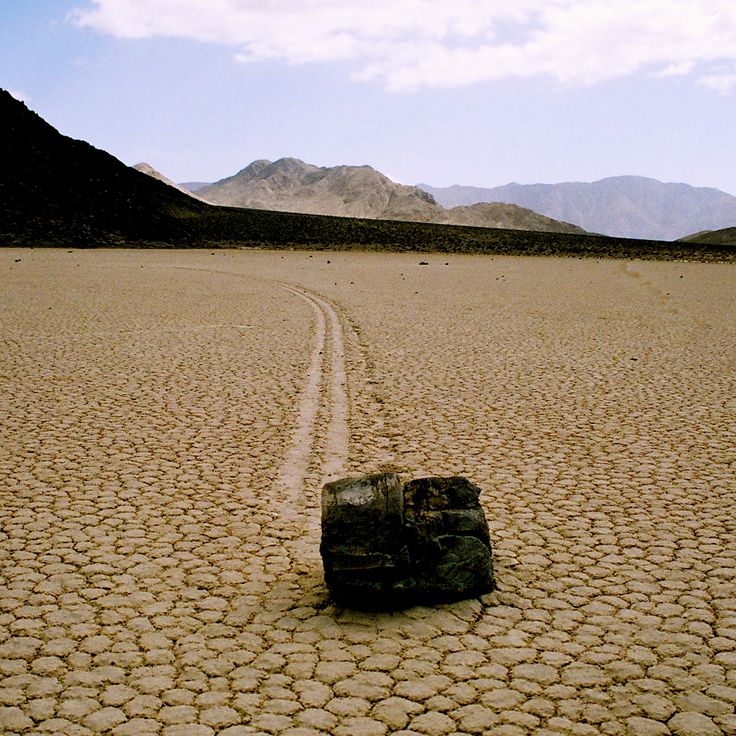
Racetrack Playa is a dry lakebed in Death Valley National Park where rocks move across the smooth clay surface, leaving long tracks behind them. This geological phenomenon was studied for decades until scientists determined that thin sheets of ice, formed during cold temperatures, push the rocks across the surface when driven by strong winds. The playa sits approximately 80 miles (130 kilometers) northwest of Furnace Creek in a remote section of the park at an elevation of 3,710 feet (1,131 meters). The tracks are most visible after rain periods, when the clay becomes wet and smooth. Access requires driving on an unpaved road that demands a high-clearance vehicle.
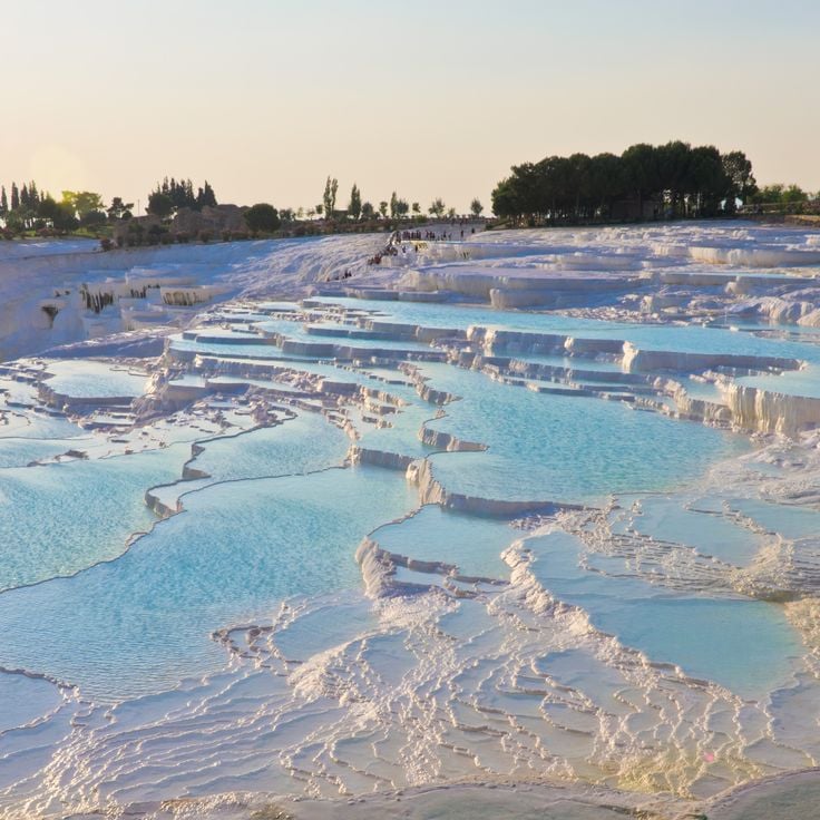
These extensive white calcium carbonate terraces formed over millennia as mineral-rich thermal water flows down the hillside, depositing layers of travertine. The formation includes around 17 springs with temperatures ranging from 95 to 212 degrees Fahrenheit (35 to 100 degrees Celsius), carrying calcium carbonate that crystallizes as the water cools and flows across the slope. Pamukkale combines geological processes with a cultural landscape, as the ruins of the ancient city of Hierapolis sit above the terraces. The site presents one of the more unusual geological formations in the Mediterranean region, where thermal activity produces visible mineral structures that contrast with the surrounding terrain.
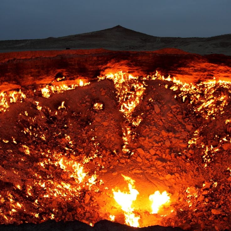
This crater in the Karakum Desert formed in 1971 when a Soviet drilling rig prospecting for natural gas collapsed, creating a 70 meter (230 foot) wide hole. Geologists ignited the escaping gas to prevent hazardous emissions, expecting the flames to burn out within weeks. Over five decades later, the fire continues to burn, making the Door to Hell a notable example of sustained geological activity. The burning crater sits approximately 260 kilometers (160 miles) north of Ashgabat in a remote desert landscape. Visitors typically reach the site through multi-hour desert drives, with the orange glow most impressive after dark.
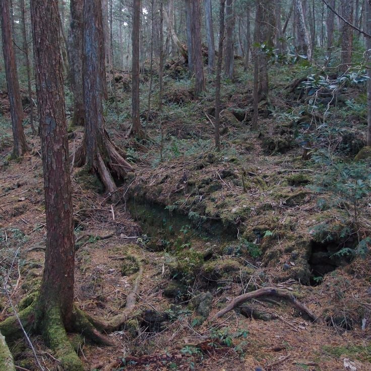
This dense forest covers roughly 12 square miles (30 square kilometers) at the northwest base of Mount Fuji and grew on lava flows created during the mountain's eruption in 864. The porous volcanic rock beneath the surface absorbs sound and creates exceptional silence, while the twisted tree roots wind through the frozen lava. The uneven nature of the ground makes navigation difficult, and local magnetic anomalies can affect compasses. Dense foliage blocks much of the sunlight throughout the growing season, and numerous lava caves run through the area. The forest demonstrates how vegetation develops on relatively young volcanic terrain, with moss and lichen covering the rocks and trees slowly gaining purchase in the volcanic substrate.
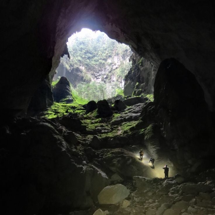
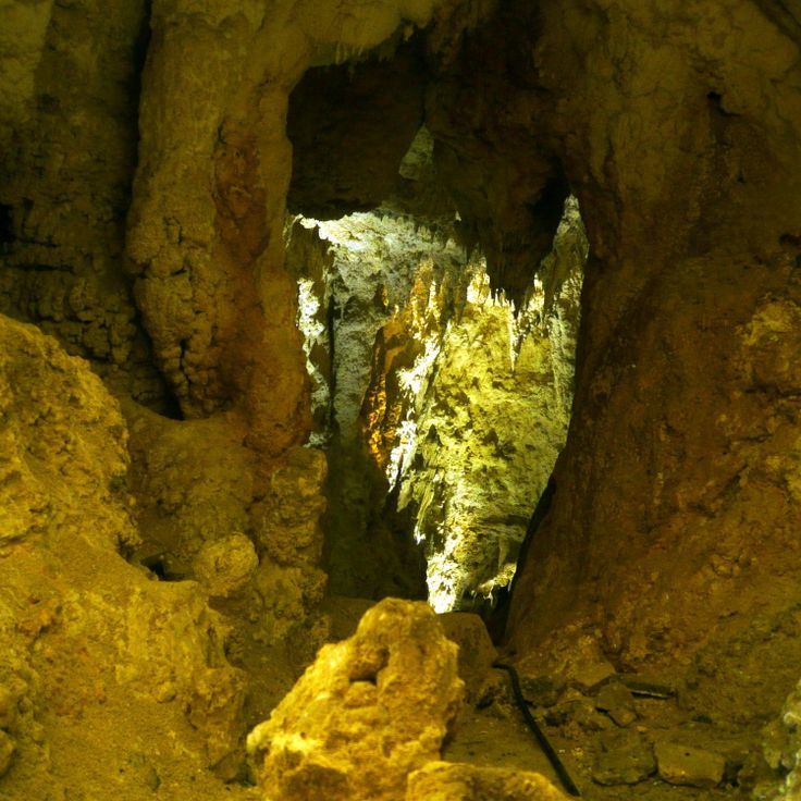
This cave extends for nine kilometers and reaches heights of 200 meters in Phong Nha-Ke Bang National Park. Hang Son Doong formed through erosion of limestone formations and contains its own weather systems as well as underground river passages. The dimensions allow jungle vegetation to grow in some chambers where light enters through ceiling collapses. Stalagmites reach heights of 70 meters here. Scientists document in this geological formation examples of large-scale cave development through water erosion over millions of years.
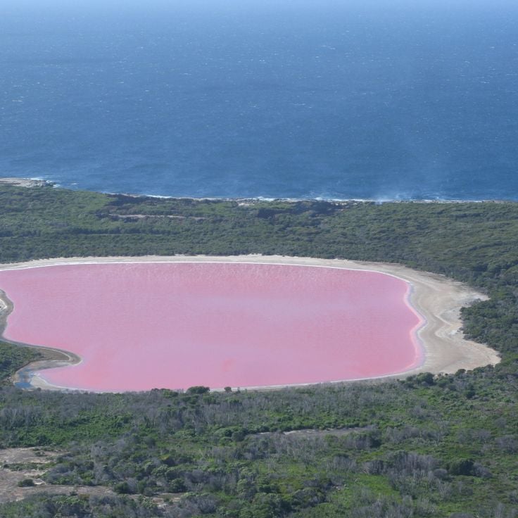
Lake Hillier on Middle Island displays a permanent pink color created by Dunaliella algae and high salt concentrations in the water. This remote lake on the southern coast of Western Australia measures roughly 2,000 feet (600 meters) in length and maintains its unusual coloration even when water is removed. The lake sits surrounded by dense eucalyptus forest and borders the turquoise Southern Ocean directly, creating a sharp color contrast. The island forms part of the Recherche Archipelago and can only be reached by helicopter or boat, with landings strictly regulated to protect the fragile ecosystem.
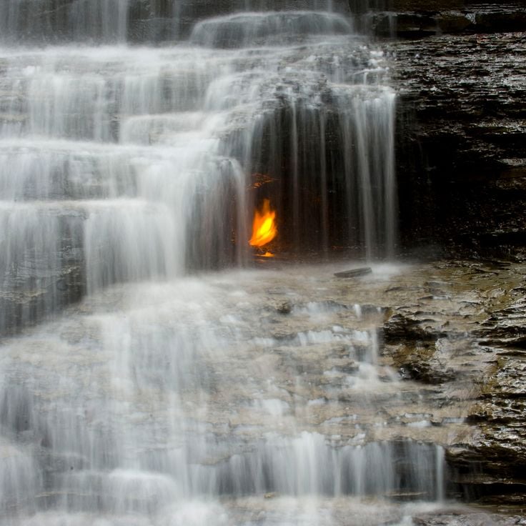
This waterfall in Shale Creek Preserve displays an unusual phenomenon where a continuous flame burns behind the curtain of water. The fire results from natural gas seeping through cracks in the underlying shale bedrock. The flame sits within a small grotto approximately halfway down the 30-foot (9-meter) cascade. Visitors reach Eternal Flame Falls via a roughly three-quarter-mile (1.2-kilometer) hiking trail through wooded terrain. The flame can occasionally extinguish and is then relit by hikers. This combination of water and fire makes the site a notable example of geological processes at work.
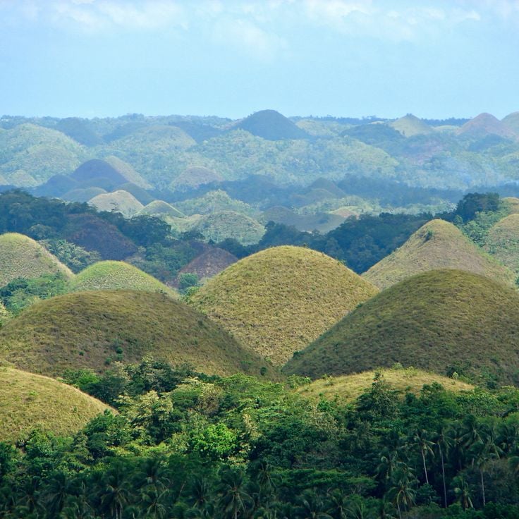
These geological formations on Bohol Island consist of 1,776 cone-shaped limestone mounds spread across 20 square miles (50 square kilometers). The mounds rise between 100 and 400 feet (30 to 120 meters) in height and display a remarkably uniform conical shape. During the dry season from February to May, the vegetation turns brown, giving the formation its name. The scientific explanation for their creation points to the weathering of coral deposits over two million years, as rainwater gradually eroded the limestone to create these symmetrical formations.
The Waitomo Glowworm Caves are limestone caverns in the northern central region of New Zealand's North Island where thousands of larvae of the endemic species Arachnocampa luminosa produce blue light through bioluminescence. The larvae live on cave ceilings and create glowing threads that become visible in darkness and attract prey. The caves formed approximately 30 million years ago through the erosion of limestone by underground rivers and contain multiple chambers with stalactites and stalagmites. Visitors explore the cave system on boat rides along an underground river where the luminous larvae on the ceiling create an effect resembling stars. The caves were explored in 1887 by Maori chief Tane Tinorau and English surveyor Fred Mace and today represent a scientifically significant example of bioluminescence within cave ecosystems.
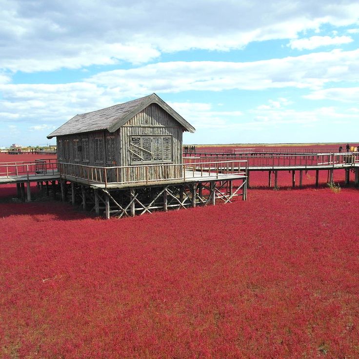
This wetland spans 26 square kilometers (about 10 square miles) and forms a natural feature through the intense red coloring of its vegetation. A specific type of seaweed adapts to the saline conditions and creates the effect. The plant undergoes a seasonal color change, reaching its most pronounced red in autumn and transforming the landscape into an extensive red expanse. The area functions as an important ecosystem for migratory birds and sits within the Liaohe River delta. Red Beach demonstrates how geological formations and specialized flora interact to produce unusual natural phenomena.
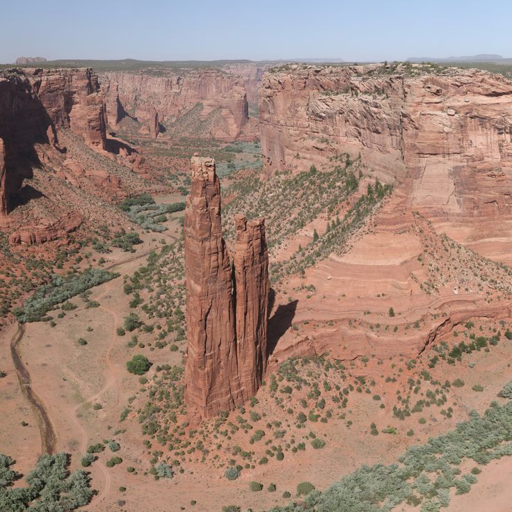
This sandstone spire rises 800 feet (244 meters) from the floor of Canyon de Chelly, forming one of the most geologically notable formations in Navajo lands. Spider Rock took shape through millions of years of erosion as wind and water carved away softer rock layers, leaving this freestanding tower. The formation draws its name from Navajo mythology, where it serves as the dwelling place of Spider Woman. The rock consists of De Chelly sandstone from the Permian period and displays distinct horizontal banding in shades of red and orange.
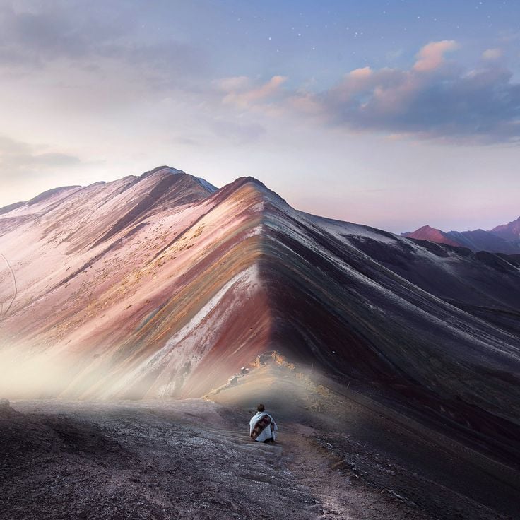
This mountain displays multicolored layers formed by mineral deposits that accumulated over millions of years through tectonic activity and erosion. The different colors result from oxidized minerals including iron, copper and sulfur in various geological strata. The rock was brought to the surface through the uplift of the Andes, while glacier retreat in recent decades has exposed the colored formations. Located at elevations above 16,400 feet (5,000 meters), the mountain shows red, yellow, green and purple bands that vary with light conditions and weather. The geological deposits come from different periods of Earth's history and document the complex development of this Andean range. Rainbow Mountain represents one of those rare natural phenomena where geological processes have created such unusual color patterns in the landscape.
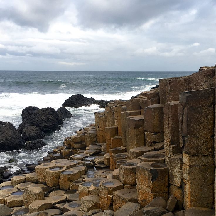
This geological formation consists of about 40,000 black basalt columns extending several miles along the coast. The Giant's Causeway formed roughly 60 million years ago through volcanic activity, as lava flows cooled and fractured into the distinctive hexagonal columns. The columns vary in height and create a natural stepping stone landscape leading from the cliff edge into the sea. The site holds UNESCO World Heritage status and demonstrates the forces of geological processes. Visitors can walk across the basalt formations and observe the precision of the natural geometry up close.
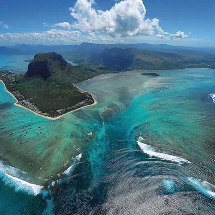
This underwater waterfall forms as sand and silt flow through ocean currents along a continental shelf, creating the optical effect of a cascading waterfall beneath the surface. The phenomenon off Mauritius demonstrates how geological structures and marine currents interact to produce one of the more unusual visual displays in the world's oceans. The sediments move down the steep underwater slope, and when viewed from above, they create the distinct appearance of a waterfall plunging into deeper water.
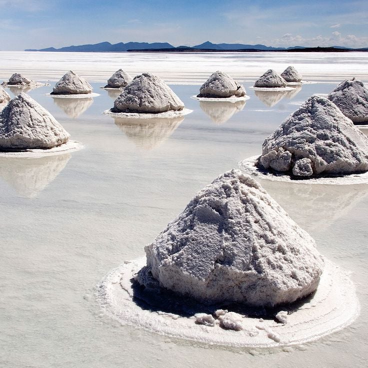
This salt flat extends across 4,086 square miles (10,582 square kilometers) and formed through the evaporation of prehistoric lakes on the Bolivian altiplano. Salar de Uyuni sits at an elevation exceeding 12,000 feet (3,656 meters) and contains an estimated 10 billion tons of salt. During the rainy season between December and April, the surface fills with a thin layer of water that mirrors the sky, creating a natural reflective effect used for calibrating satellites. The flat also holds several islands covered with cacti, including Incahuasi, and serves as a breeding ground for flamingos that gather in shallow lagoons at its edges.
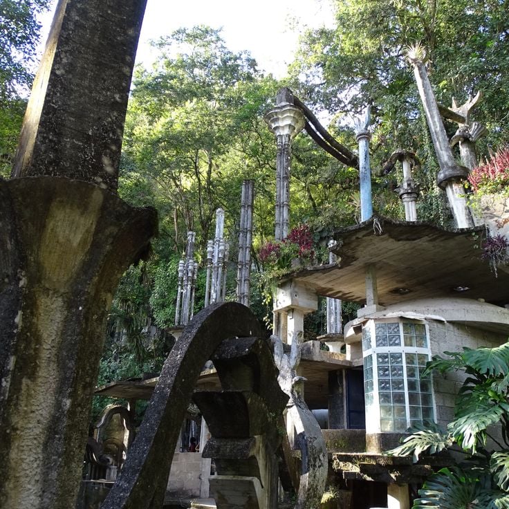
This surreal garden spans 80 acres (32 hectares) of Mexican rainforest and displays the architectural vision of British poet Edward James. The site contains more than 30 concrete structures, including spiral staircases leading nowhere, organically shaped columns and labyrinthine pathways winding through tropical vegetation. James began the project in 1962 and worked on it until his death in 1984. The structures combine Art Deco elements with organic forms, with plants growing through open roofs and around columns. The site sits in an area receiving approximately 120 inches (3,000 millimeters) of rainfall annually, resulting in dense vegetation and frequent waterfalls.
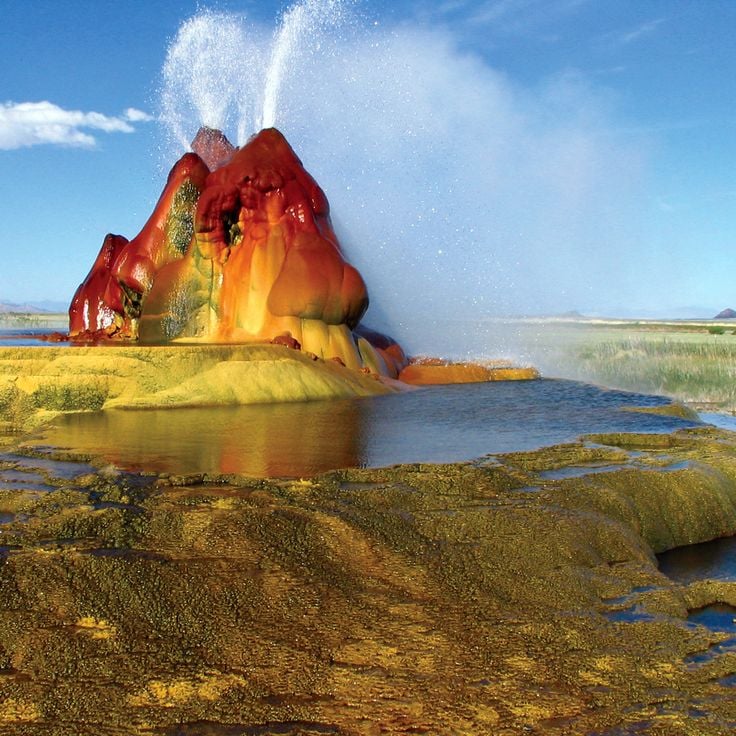
This geyser formed in 1964 when a failed attempt to drill for geothermal water left an opening in the earth's crust. Mineral-rich water has since emerged continuously to the surface, building terraced deposits over the decades. The minerals create red, green and orange colorations across the formations. The site sits on private land in the Black Rock Desert and can only be accessed through guided tours. The structure continues to grow through ongoing mineral deposition, changing its appearance over time.
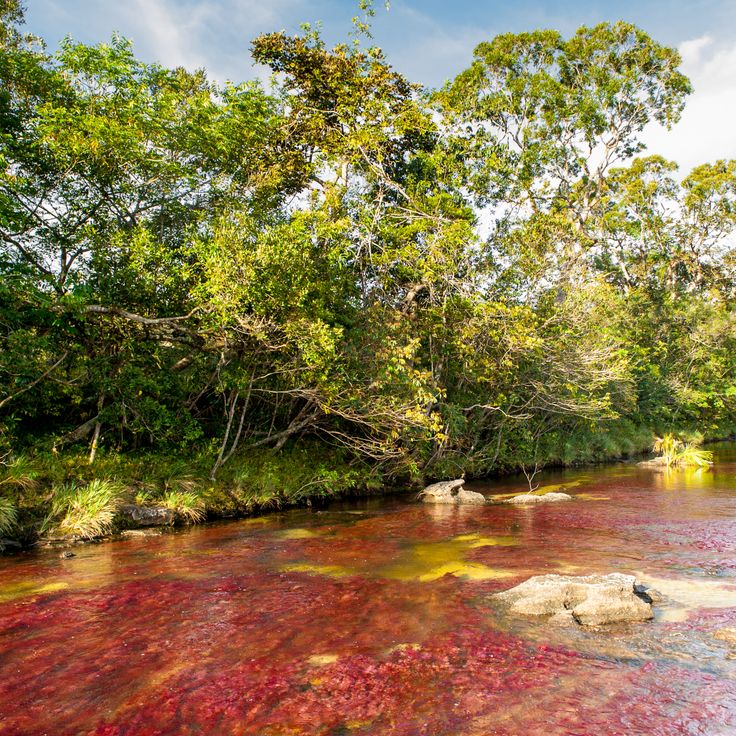
This river in the Colombian highlands displays intense red, yellow, green, blue and black tones along its riverbed from July through November. The colors come from an endemic aquatic plant called Macarenia clavigera, which develops in combination with clear water, sand and algae. The river extends about 62 miles (100 kilometers) through the Serranía de la Macarena and remains relatively colorless most of the year. The most intense colors appear during the transition period between rainy and dry seasons, when water levels and sunlight create optimal conditions for the plant. Visitors reach the area through La Macarena and hike to various viewpoints along the river.
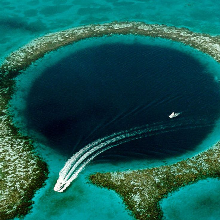
The Great Blue Hole is a circular underwater crater in the coral reef off the coast of Belize, measuring 300 meters (roughly 985 feet) in diameter and 125 meters (about 410 feet) deep. This geological formation developed during the Ice Age when sea levels were lower, allowing rainwater to carve out a limestone cave that later flooded as ocean levels rose. The deep blue coloration, created by the sudden depth, contrasts sharply with the turquoise waters of the surrounding lagoon. Divers can explore the circular opening to observe distinct geological layers and stalactite formations that provide insight into the region's climatic history.
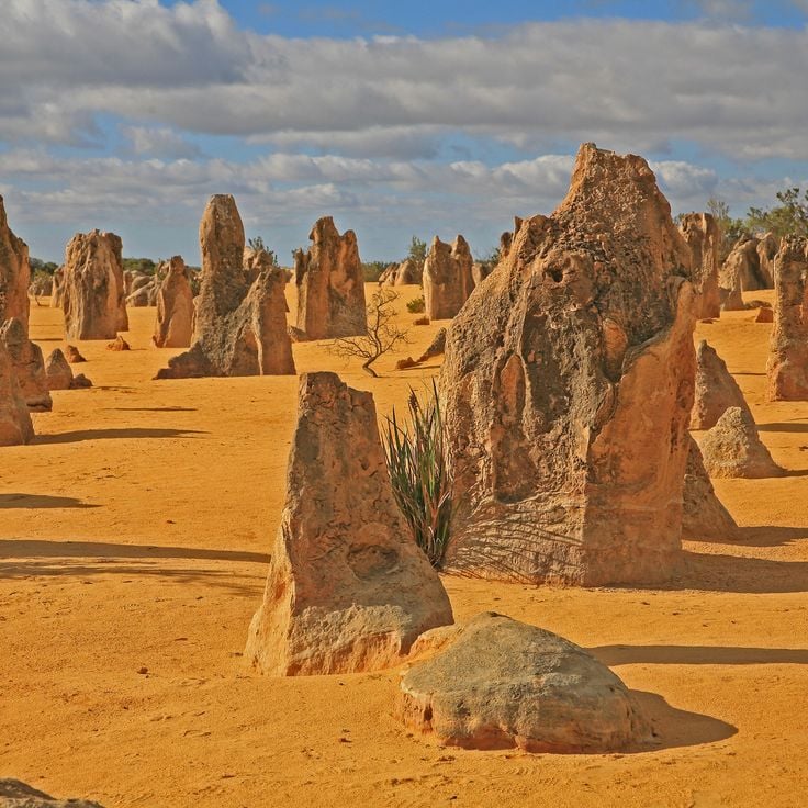
This desert in Nambung National Park presents thousands of limestone pillars rising from yellow sand, formed through the petrification of tree stumps millions of years ago. The formations vary in height from a few inches to 12 feet (3.5 meters) and spread across several square miles. Scientists explain their creation through the calcification of organic material during a period when the region was a coastal forest. The pillars display different shapes and textures, with some tapering to points and others showing rounded tops. Visitors can drive or walk through the area on marked paths, with early morning and late afternoon hours providing the best light for observing the geological structures.
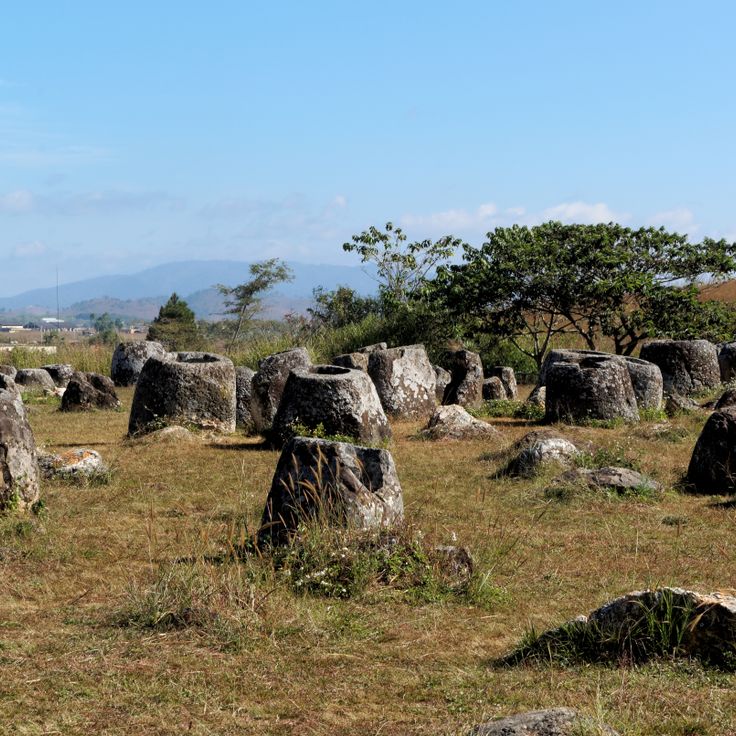
These prehistoric stone jars scattered across several sites on the Xieng Khouang Plateau represent one of Southeast Asia's most puzzling archaeological landscapes. More than 2000 sandstone vessels, with the largest reaching 10 feet (3 meters) in height and weighing several tons, were created approximately 2000 years ago by an unknown culture. The jars vary in size and shape, with some originally topped by stone lids. Archaeologists believe they were connected to burial practices, though their precise purpose remains debated. The sites sit across open grasslands and hills, with Site 1 near Phonsavan containing the most numerous and largest specimens.
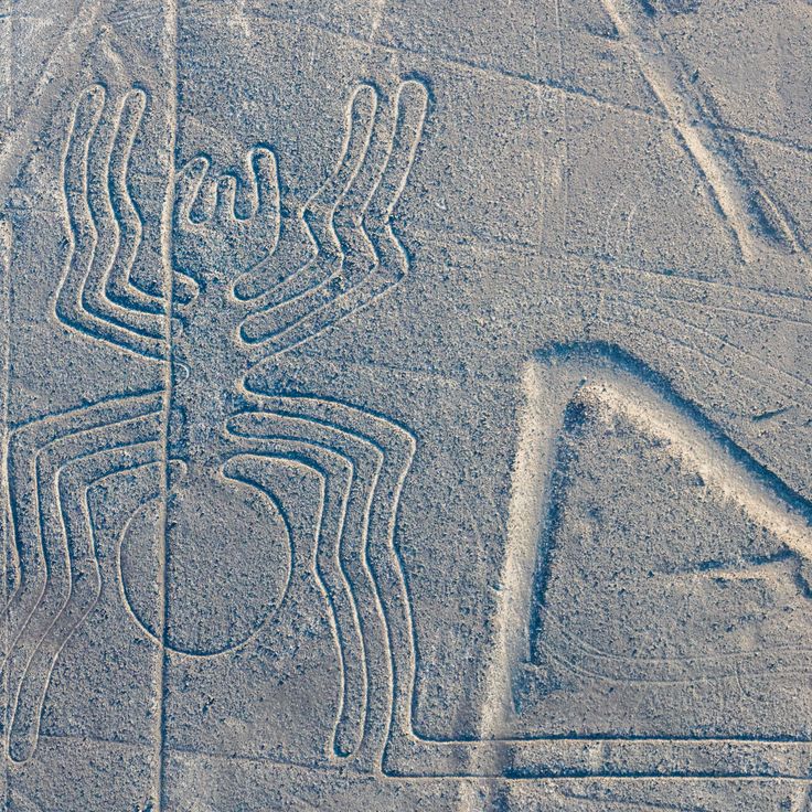
The Nazca Lines are geoglyphs etched into the Peruvian desert more than 2,000 years ago, depicting humans, animals and geometric patterns across an arid plateau. These ground drawings were created by the Nazca culture between 500 BCE and 500 CE by removing the dark surface stones to reveal lighter soil beneath. The designs include a hummingbird, spider, monkey and various other figures, some stretching more than 650 feet (200 meters) in length. This collection of unusual natural and geological formations is best viewed from the air, and the lines continue to raise questions about their original purpose and the methods used to create them.
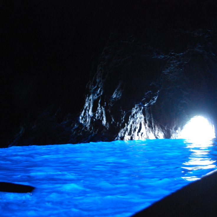
This sea cave on the coast of Capri became known for a natural light refraction phenomenon. Sunlight enters through an underwater opening and creates an intense blue luminosity inside, making the entire water appear in bright blue. The entrance to the grotto is only about 4 feet 3 inches high and 3 feet wide, so visitors must enter in small rowboats and often lie down to pass through the low opening. This geological formation represents one of the unusual natural phenomena where specific light conditions and water depth combine to create a visual effect that has been scientifically documented. The Blue Grotto demonstrates how geological features and optical physics can produce distinctive natural displays.
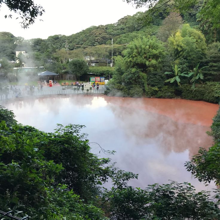
This thermal spring in Beppu is one of Japan's most recognized geological phenomena among the hot springs in the region. The water reaches a temperature of 172 degrees Fahrenheit (78 degrees Celsius) and displays a pronounced red coloration caused by iron oxide. The spring belongs to the Jigoku, a group of thermal springs that are unsuitable for bathing due to their extreme temperatures but serve as a compelling example of volcanic activity. The intense red tint of the water and the rising steam make this geological formation a clear illustration of the mineral-rich thermal waters that emerge from the volcanically active underground.
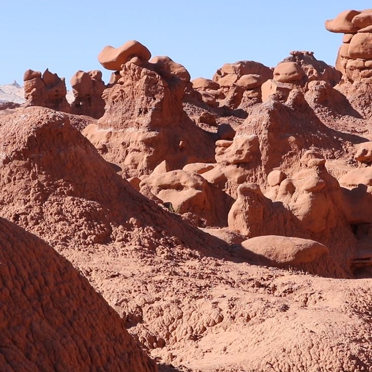
Goblin Valley State Park contains thousands of sandstone formations created by erosion over millions of years. The formations reach heights up to several meters and display rounded, mushroom-shaped structures in red and orange rock. Located in the San Rafael Desert, the park allows visitors to walk among densely grouped stone pillars. The geological structures consist of Entrada Sandstone from the Jurassic period and were shaped by wind and water erosion.
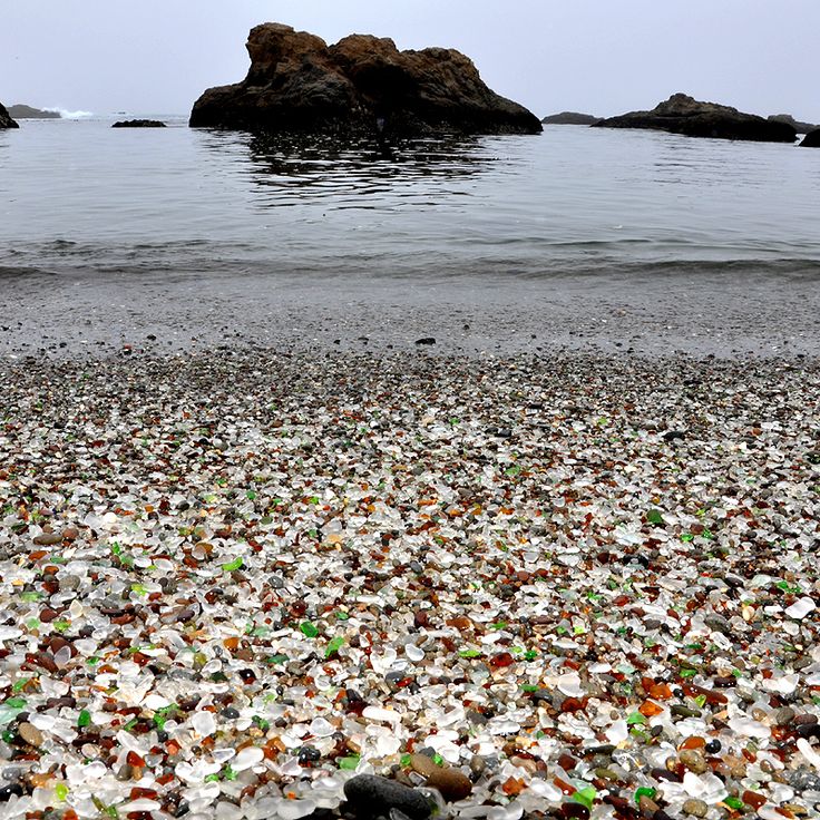
This coastal stretch contains millions of glass pieces smoothed into colorful, polished fragments by decades of ocean currents. Glass Beach formed from a former municipal dump site used from 1906 to 1967, when glass and other refuse were discarded into the sea. Wave action tumbled and ground the glass shards over time, transforming them into smooth, pebble-like stones. The most common colors are green, brown, and white, while blue and red pieces are rarer. The site is part of MacKerricher State Park and demonstrates how natural processes can transform human waste into a geological feature. Collecting glass is now prohibited to preserve this phenomenon.
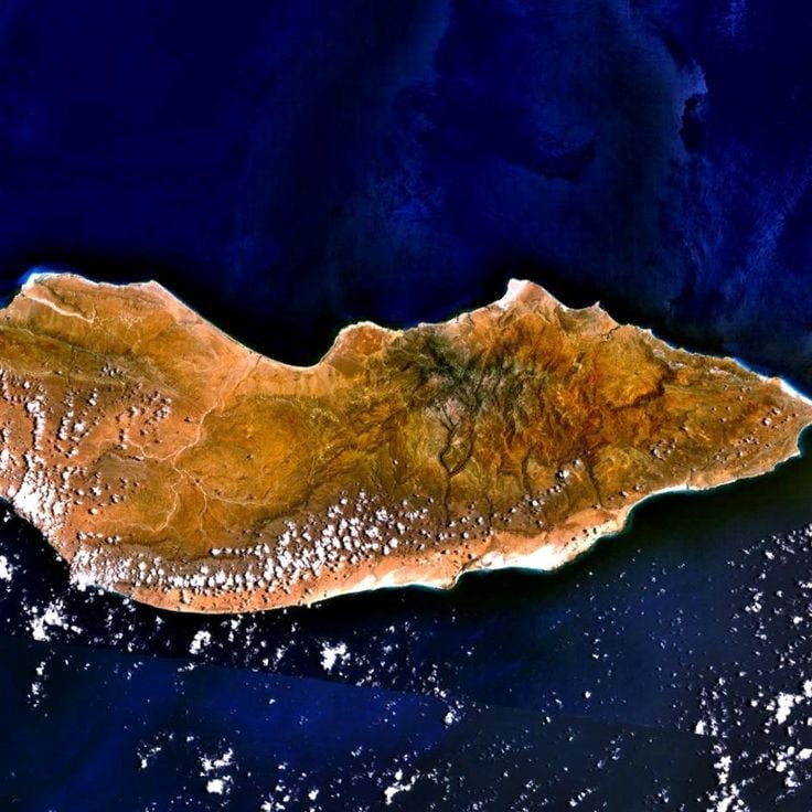
This island in the Indian Ocean displays unusual plant life shaped by millions of years of geographic isolation. Socotra's landscape is defined by dragon blood trees with their umbrella-shaped crowns and bottle-shaped desert roses. The island harbors more than 700 endemic species, representing roughly one-third of its plant life. These unusual forms and biological distinctiveness make Socotra a significant example of evolutionary adaptation under isolated conditions. The highlands reach elevations up to 1,500 meters (4,900 feet) above sea level.
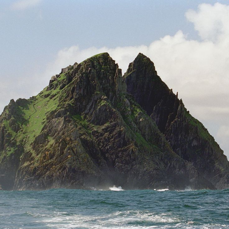
Skellig Michael rises as a steep, rocky island 7.5 miles (12 kilometers) off the Kerry coast in the Atlantic. The 6th-century monastery perched on its windswept summit includes beehive-shaped stone huts and more than 600 steps carved into the rock. The remarkable location of this early Christian settlement, suspended between sky and sea, makes it one of the most striking geological and archaeological sites in the collection. Monks lived here for centuries in extreme conditions, creating a community that withstood Atlantic storms.
This Jordanian desert valley spans 280 square miles (720 square kilometers) of red sand plains between sandstone formations sculpted by wind and water erosion over millions of years. The landscape of Wadi Rum served as a filming location for several space movies due to its resemblance to Mars. Rock walls rise up to 5,740 feet (1,750 meters), while narrow canyons and natural rock arches document the geological history of the region. Bedouin tribes have traversed this area for centuries, leaving petroglyphs carved into the rock faces.
Racetrack Playa is a dry lakebed in Death Valley National Park where rocks move across the smooth clay surface, leaving long tracks behind them. This geological phenomenon was studied for decades until scientists determined that thin sheets of ice, formed during cold temperatures, push the rocks across the surface when driven by strong winds. The playa sits approximately 80 miles (130 kilometers) northwest of Furnace Creek in a remote section of the park at an elevation of 3,710 feet (1,131 meters). The tracks are most visible after rain periods, when the clay becomes wet and smooth. Access requires driving on an unpaved road that demands a high-clearance vehicle.
These extensive white calcium carbonate terraces formed over millennia as mineral-rich thermal water flows down the hillside, depositing layers of travertine. The formation includes around 17 springs with temperatures ranging from 95 to 212 degrees Fahrenheit (35 to 100 degrees Celsius), carrying calcium carbonate that crystallizes as the water cools and flows across the slope. Pamukkale combines geological processes with a cultural landscape, as the ruins of the ancient city of Hierapolis sit above the terraces. The site presents one of the more unusual geological formations in the Mediterranean region, where thermal activity produces visible mineral structures that contrast with the surrounding terrain.
This crater in the Karakum Desert formed in 1971 when a Soviet drilling rig prospecting for natural gas collapsed, creating a 70 meter (230 foot) wide hole. Geologists ignited the escaping gas to prevent hazardous emissions, expecting the flames to burn out within weeks. Over five decades later, the fire continues to burn, making the Door to Hell a notable example of sustained geological activity. The burning crater sits approximately 260 kilometers (160 miles) north of Ashgabat in a remote desert landscape. Visitors typically reach the site through multi-hour desert drives, with the orange glow most impressive after dark.
This dense forest covers roughly 12 square miles (30 square kilometers) at the northwest base of Mount Fuji and grew on lava flows created during the mountain's eruption in 864. The porous volcanic rock beneath the surface absorbs sound and creates exceptional silence, while the twisted tree roots wind through the frozen lava. The uneven nature of the ground makes navigation difficult, and local magnetic anomalies can affect compasses. Dense foliage blocks much of the sunlight throughout the growing season, and numerous lava caves run through the area. The forest demonstrates how vegetation develops on relatively young volcanic terrain, with moss and lichen covering the rocks and trees slowly gaining purchase in the volcanic substrate.
This cave extends for nine kilometers and reaches heights of 200 meters in Phong Nha-Ke Bang National Park. Hang Son Doong formed through erosion of limestone formations and contains its own weather systems as well as underground river passages. The dimensions allow jungle vegetation to grow in some chambers where light enters through ceiling collapses. Stalagmites reach heights of 70 meters here. Scientists document in this geological formation examples of large-scale cave development through water erosion over millions of years.
Lake Hillier on Middle Island displays a permanent pink color created by Dunaliella algae and high salt concentrations in the water. This remote lake on the southern coast of Western Australia measures roughly 2,000 feet (600 meters) in length and maintains its unusual coloration even when water is removed. The lake sits surrounded by dense eucalyptus forest and borders the turquoise Southern Ocean directly, creating a sharp color contrast. The island forms part of the Recherche Archipelago and can only be reached by helicopter or boat, with landings strictly regulated to protect the fragile ecosystem.
This waterfall in Shale Creek Preserve displays an unusual phenomenon where a continuous flame burns behind the curtain of water. The fire results from natural gas seeping through cracks in the underlying shale bedrock. The flame sits within a small grotto approximately halfway down the 30-foot (9-meter) cascade. Visitors reach Eternal Flame Falls via a roughly three-quarter-mile (1.2-kilometer) hiking trail through wooded terrain. The flame can occasionally extinguish and is then relit by hikers. This combination of water and fire makes the site a notable example of geological processes at work.
These geological formations on Bohol Island consist of 1,776 cone-shaped limestone mounds spread across 20 square miles (50 square kilometers). The mounds rise between 100 and 400 feet (30 to 120 meters) in height and display a remarkably uniform conical shape. During the dry season from February to May, the vegetation turns brown, giving the formation its name. The scientific explanation for their creation points to the weathering of coral deposits over two million years, as rainwater gradually eroded the limestone to create these symmetrical formations.
The Waitomo Glowworm Caves are limestone caverns in the northern central region of New Zealand's North Island where thousands of larvae of the endemic species Arachnocampa luminosa produce blue light through bioluminescence. The larvae live on cave ceilings and create glowing threads that become visible in darkness and attract prey. The caves formed approximately 30 million years ago through the erosion of limestone by underground rivers and contain multiple chambers with stalactites and stalagmites. Visitors explore the cave system on boat rides along an underground river where the luminous larvae on the ceiling create an effect resembling stars. The caves were explored in 1887 by Maori chief Tane Tinorau and English surveyor Fred Mace and today represent a scientifically significant example of bioluminescence within cave ecosystems.
This wetland spans 26 square kilometers (about 10 square miles) and forms a natural feature through the intense red coloring of its vegetation. A specific type of seaweed adapts to the saline conditions and creates the effect. The plant undergoes a seasonal color change, reaching its most pronounced red in autumn and transforming the landscape into an extensive red expanse. The area functions as an important ecosystem for migratory birds and sits within the Liaohe River delta. Red Beach demonstrates how geological formations and specialized flora interact to produce unusual natural phenomena.
This sandstone spire rises 800 feet (244 meters) from the floor of Canyon de Chelly, forming one of the most geologically notable formations in Navajo lands. Spider Rock took shape through millions of years of erosion as wind and water carved away softer rock layers, leaving this freestanding tower. The formation draws its name from Navajo mythology, where it serves as the dwelling place of Spider Woman. The rock consists of De Chelly sandstone from the Permian period and displays distinct horizontal banding in shades of red and orange.
This mountain displays multicolored layers formed by mineral deposits that accumulated over millions of years through tectonic activity and erosion. The different colors result from oxidized minerals including iron, copper and sulfur in various geological strata. The rock was brought to the surface through the uplift of the Andes, while glacier retreat in recent decades has exposed the colored formations. Located at elevations above 16,400 feet (5,000 meters), the mountain shows red, yellow, green and purple bands that vary with light conditions and weather. The geological deposits come from different periods of Earth's history and document the complex development of this Andean range. Rainbow Mountain represents one of those rare natural phenomena where geological processes have created such unusual color patterns in the landscape.
This geological formation consists of about 40,000 black basalt columns extending several miles along the coast. The Giant's Causeway formed roughly 60 million years ago through volcanic activity, as lava flows cooled and fractured into the distinctive hexagonal columns. The columns vary in height and create a natural stepping stone landscape leading from the cliff edge into the sea. The site holds UNESCO World Heritage status and demonstrates the forces of geological processes. Visitors can walk across the basalt formations and observe the precision of the natural geometry up close.
This underwater waterfall forms as sand and silt flow through ocean currents along a continental shelf, creating the optical effect of a cascading waterfall beneath the surface. The phenomenon off Mauritius demonstrates how geological structures and marine currents interact to produce one of the more unusual visual displays in the world's oceans. The sediments move down the steep underwater slope, and when viewed from above, they create the distinct appearance of a waterfall plunging into deeper water.
This salt flat extends across 4,086 square miles (10,582 square kilometers) and formed through the evaporation of prehistoric lakes on the Bolivian altiplano. Salar de Uyuni sits at an elevation exceeding 12,000 feet (3,656 meters) and contains an estimated 10 billion tons of salt. During the rainy season between December and April, the surface fills with a thin layer of water that mirrors the sky, creating a natural reflective effect used for calibrating satellites. The flat also holds several islands covered with cacti, including Incahuasi, and serves as a breeding ground for flamingos that gather in shallow lagoons at its edges.
This surreal garden spans 80 acres (32 hectares) of Mexican rainforest and displays the architectural vision of British poet Edward James. The site contains more than 30 concrete structures, including spiral staircases leading nowhere, organically shaped columns and labyrinthine pathways winding through tropical vegetation. James began the project in 1962 and worked on it until his death in 1984. The structures combine Art Deco elements with organic forms, with plants growing through open roofs and around columns. The site sits in an area receiving approximately 120 inches (3,000 millimeters) of rainfall annually, resulting in dense vegetation and frequent waterfalls.
This geyser formed in 1964 when a failed attempt to drill for geothermal water left an opening in the earth's crust. Mineral-rich water has since emerged continuously to the surface, building terraced deposits over the decades. The minerals create red, green and orange colorations across the formations. The site sits on private land in the Black Rock Desert and can only be accessed through guided tours. The structure continues to grow through ongoing mineral deposition, changing its appearance over time.
This river in the Colombian highlands displays intense red, yellow, green, blue and black tones along its riverbed from July through November. The colors come from an endemic aquatic plant called Macarenia clavigera, which develops in combination with clear water, sand and algae. The river extends about 62 miles (100 kilometers) through the Serranía de la Macarena and remains relatively colorless most of the year. The most intense colors appear during the transition period between rainy and dry seasons, when water levels and sunlight create optimal conditions for the plant. Visitors reach the area through La Macarena and hike to various viewpoints along the river.
The Great Blue Hole is a circular underwater crater in the coral reef off the coast of Belize, measuring 300 meters (roughly 985 feet) in diameter and 125 meters (about 410 feet) deep. This geological formation developed during the Ice Age when sea levels were lower, allowing rainwater to carve out a limestone cave that later flooded as ocean levels rose. The deep blue coloration, created by the sudden depth, contrasts sharply with the turquoise waters of the surrounding lagoon. Divers can explore the circular opening to observe distinct geological layers and stalactite formations that provide insight into the region's climatic history.
This desert in Nambung National Park presents thousands of limestone pillars rising from yellow sand, formed through the petrification of tree stumps millions of years ago. The formations vary in height from a few inches to 12 feet (3.5 meters) and spread across several square miles. Scientists explain their creation through the calcification of organic material during a period when the region was a coastal forest. The pillars display different shapes and textures, with some tapering to points and others showing rounded tops. Visitors can drive or walk through the area on marked paths, with early morning and late afternoon hours providing the best light for observing the geological structures.
These prehistoric stone jars scattered across several sites on the Xieng Khouang Plateau represent one of Southeast Asia's most puzzling archaeological landscapes. More than 2000 sandstone vessels, with the largest reaching 10 feet (3 meters) in height and weighing several tons, were created approximately 2000 years ago by an unknown culture. The jars vary in size and shape, with some originally topped by stone lids. Archaeologists believe they were connected to burial practices, though their precise purpose remains debated. The sites sit across open grasslands and hills, with Site 1 near Phonsavan containing the most numerous and largest specimens.
The Nazca Lines are geoglyphs etched into the Peruvian desert more than 2,000 years ago, depicting humans, animals and geometric patterns across an arid plateau. These ground drawings were created by the Nazca culture between 500 BCE and 500 CE by removing the dark surface stones to reveal lighter soil beneath. The designs include a hummingbird, spider, monkey and various other figures, some stretching more than 650 feet (200 meters) in length. This collection of unusual natural and geological formations is best viewed from the air, and the lines continue to raise questions about their original purpose and the methods used to create them.
This sea cave on the coast of Capri became known for a natural light refraction phenomenon. Sunlight enters through an underwater opening and creates an intense blue luminosity inside, making the entire water appear in bright blue. The entrance to the grotto is only about 4 feet 3 inches high and 3 feet wide, so visitors must enter in small rowboats and often lie down to pass through the low opening. This geological formation represents one of the unusual natural phenomena where specific light conditions and water depth combine to create a visual effect that has been scientifically documented. The Blue Grotto demonstrates how geological features and optical physics can produce distinctive natural displays.
This thermal spring in Beppu is one of Japan's most recognized geological phenomena among the hot springs in the region. The water reaches a temperature of 172 degrees Fahrenheit (78 degrees Celsius) and displays a pronounced red coloration caused by iron oxide. The spring belongs to the Jigoku, a group of thermal springs that are unsuitable for bathing due to their extreme temperatures but serve as a compelling example of volcanic activity. The intense red tint of the water and the rising steam make this geological formation a clear illustration of the mineral-rich thermal waters that emerge from the volcanically active underground.
Goblin Valley State Park contains thousands of sandstone formations created by erosion over millions of years. The formations reach heights up to several meters and display rounded, mushroom-shaped structures in red and orange rock. Located in the San Rafael Desert, the park allows visitors to walk among densely grouped stone pillars. The geological structures consist of Entrada Sandstone from the Jurassic period and were shaped by wind and water erosion.
This coastal stretch contains millions of glass pieces smoothed into colorful, polished fragments by decades of ocean currents. Glass Beach formed from a former municipal dump site used from 1906 to 1967, when glass and other refuse were discarded into the sea. Wave action tumbled and ground the glass shards over time, transforming them into smooth, pebble-like stones. The most common colors are green, brown, and white, while blue and red pieces are rarer. The site is part of MacKerricher State Park and demonstrates how natural processes can transform human waste into a geological feature. Collecting glass is now prohibited to preserve this phenomenon.
This island in the Indian Ocean displays unusual plant life shaped by millions of years of geographic isolation. Socotra's landscape is defined by dragon blood trees with their umbrella-shaped crowns and bottle-shaped desert roses. The island harbors more than 700 endemic species, representing roughly one-third of its plant life. These unusual forms and biological distinctiveness make Socotra a significant example of evolutionary adaptation under isolated conditions. The highlands reach elevations up to 1,500 meters (4,900 feet) above sea level.
Skellig Michael rises as a steep, rocky island 7.5 miles (12 kilometers) off the Kerry coast in the Atlantic. The 6th-century monastery perched on its windswept summit includes beehive-shaped stone huts and more than 600 steps carved into the rock. The remarkable location of this early Christian settlement, suspended between sky and sea, makes it one of the most striking geological and archaeological sites in the collection. Monks lived here for centuries in extreme conditions, creating a community that withstood Atlantic storms.
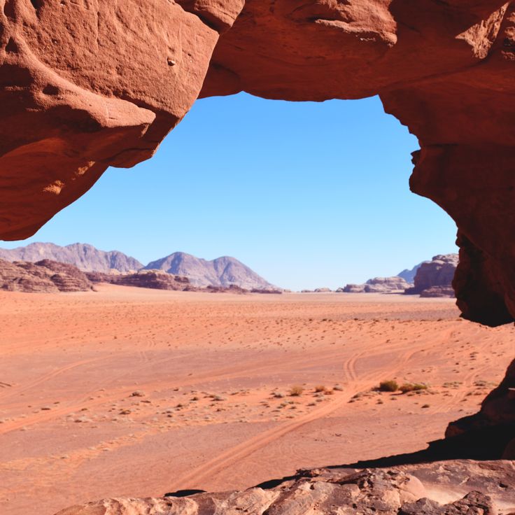
This Jordanian desert valley spans 280 square miles (720 square kilometers) of red sand plains between sandstone formations sculpted by wind and water erosion over millions of years. The landscape of Wadi Rum served as a filming location for several space movies due to its resemblance to Mars. Rock walls rise up to 5,740 feet (1,750 meters), while narrow canyons and natural rock arches document the geological history of the region. Bedouin tribes have traversed this area for centuries, leaving petroglyphs carved into the rock faces.