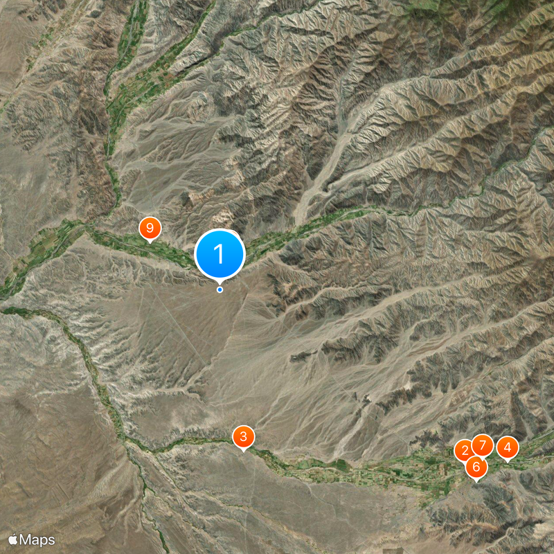
Nazca Lines, Archaeological site in Nazca Desert, Peru.
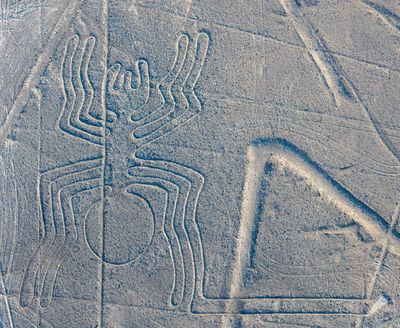
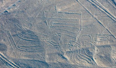
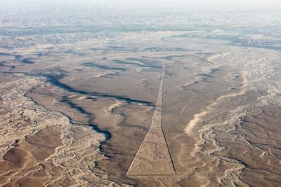
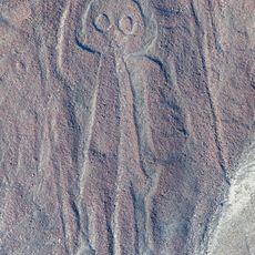
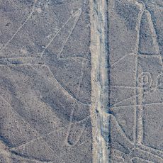
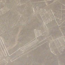
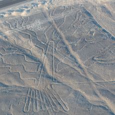
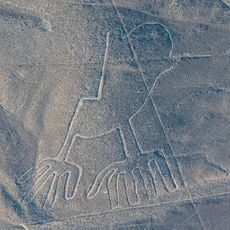
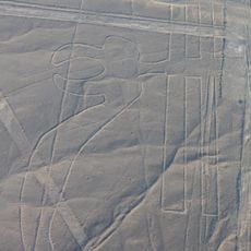
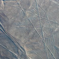
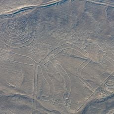
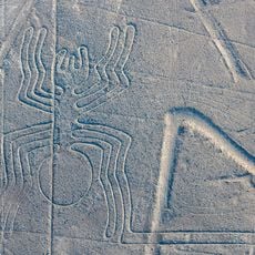
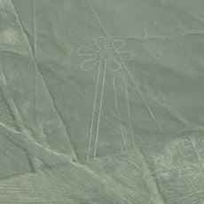
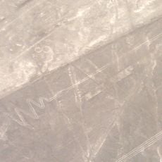
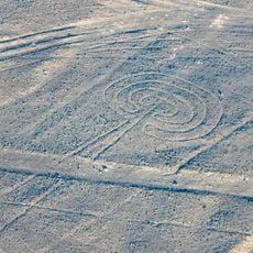
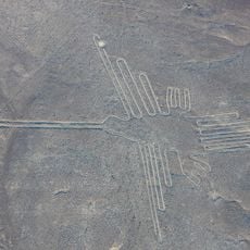
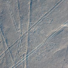
The Nazca Lines are an archaeological site in southern Peru's desert with over 800 straight lines, geometric patterns and figurative representations extending across 450 square kilometers (174 square miles). The figures show animals such as whales, birds and reptiles, along with plant motifs and human forms, created by removing dark surface stones to expose lighter ground beneath.
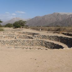
The Nasca civilization created these ground markings between 500 BCE and 500 CE in the pampa region south of today's Nazca town. German mathematician Maria Reiche systematically documented the structures starting in 1946 and advocated for their preservation before UNESCO declared the site a World Heritage location in 1994.
Local communities regard the site as spiritual heritage from their ancestors and occasionally conduct ceremonial visits to the locations. Many residents of the region work as guides or support tourism, which has become the primary economic activity in the area.
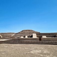
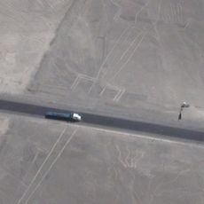
Aircraft tours from Maria Reiche Airport in Nazca allow visitors to observe the formations from above, while the observation tower along the Panamerican Highway offers a ground view of some figures. The dry season from May through October provides the best viewing conditions without atmospheric interference.
Japanese researchers from Yamagata University discovered 168 new geoglyphs between 2016 and 2019 using drones and machine learning technology, many barely visible from ground level. One geoglyph depicts a humanoid figure with a staff, revealed only in 2020 through erosion and located mere yards from a parking area.
Location: Ica Department
Location: Nasca Province
Inception: 200 BCE
Creator: Nazca culture
Operator: Ministerio de Cultura
GPS coordinates: -14.69750,-75.13500
Latest update: December 2, 2025 22:04
This collection presents extraordinary natural phenomena and geological formations across all continents, from salt flats and volcanic crater fields to underground cave systems and landscapes shaped by mineral deposits. The featured sites display rare geological processes: moving stones leave mysterious tracks across California desert playas, methane gas feeds flames in a Turkmenistan crater for decades, and thermal springs create white travertine terraces in the Turkish countryside. Coral reefs form circular structures off the coast of Belize, while chemical reactions turn lakes pink in Australia and rivers brilliant colors in Colombia. The geological features include hexagonal basalt columns along the Northern Irish coast, conical limestone hills on Philippine islands, and mushroom shaped sandstone formations in Utah. Caves in New Zealand house thousands of bioluminescent larvae, while one of the world's largest caverns lies beneath Vietnamese mountains. Locations range from a geyser studded desert basin in Nevada to red algae carpets along Chinese shores to isolated islands off the Yemeni coast with endemic flora. This collection encompasses both ancient archaeological puzzles like stone jars in Laos and ground drawings in Peru, as well as natural optical illusions such as apparent underwater cascades off Mauritius.
These archaeological sites document the development of human civilizations across thousands of years. They range from the earliest known temple structures like Göbekli Tepe in Turkey, dated to around 9500 BCE, to the preserved remains of Pompeii, frozen in time by a volcanic eruption in 79 CE. Each location offers insights into the technical abilities, religious beliefs, and social structures of past cultures. The collection includes monuments such as the Great Pyramid of Giza in Egypt, standing for over 4,500 years, and Machu Picchu in the Peruvian Andes, a 15th-century Inca stronghold at 7,970 feet (2,430 meters). In China, the Terracotta Army guards the tomb of the first emperor with thousands of life-size soldiers, while Angkor Wat in Cambodia represents the largest religious complex in the world. European sites like Stonehenge in England and the Acropolis in Athens demonstrate prehistoric engineering and classical Greek architecture. These places connect visitors to the societies that built them centuries or millennia ago.
This collection encompasses ancient stone monuments and sacred sites from across the globe, ranging from the Easter Island Moai to the Great Wall of China. The structures represent millennia of human engineering and include religious temples, fortifications, burial sites, and astronomical installations. Many of these locations retain cultural significance for local communities today. Examples include prehistoric sites such as Göbekli Tepe in Turkey and Skara Brae in the Orkney Islands, alongside monumental constructions like the Parthenon in Athens, Angkor Wat in Cambodia, and the Pyramids of Giza in Egypt. The collection also features lesser known treasures including the Megalithic Temples of Malta, Nan Madol in Micronesia, and Great Zimbabwe. These sites provide insight into ancient cultures, religious practices, and architectural achievements that continue to draw visitors from around the world.
Satellite imagery has transformed how we view remote locations on Earth, offering perspectives on places that are often invisible or difficult to reach from ground level. This collection presents natural formations, artificial structures and historical sites from an aerial vantage point. From geological features like the circular Richat Structure in Mauritania's desert to ancient geoglyphs and modern engineering achievements, these images provide a distinct view of our planet's diversity. Locations documented include the geometric Nazca Lines in Peru, the pyramid structure of El Castillo in Mexico's Yucatán Peninsula and the Badlands Guardian in Alberta, a natural rock formation that resembles a head wearing headphones when seen from above. The collection also features Palm Jumeirah in Dubai, an artificial archipelago shaped like a palm tree, the vivid blue potash evaporation ponds in Utah, the pink waters of Lake Hillier in Western Australia and the volcanic island of Surtsey off Iceland. Additional examples include the Atacama Giant in Chile, a prehistoric geoglyph, the heart shaped Galesnjak island off Croatia's coast and the ship graveyard of the former Aral Sea in Uzbekistan, which documents the ecological consequences of human intervention.
Puquios
25.3 km
Cahuachi
13.6 km
Chauchilla Cemetery
38.9 km
Cantalloc Aqueducts
28.1 km
San Fernando National Reservoir
35 km
Museo Maria Reiche
1.7 km
Museo Arqueológico Antonini
26.2 km
San José of Nazca church
3.1 km
Saint Xavier of Nazca church
7.2 km
Nazca Owlman geoglyph
8 km
Nazca Whale geoglyph
20.1 km
Cahuachi Pyramids
13.6 km
Nazca Lizard geoglyph
2.3 km
Nazca Pelican geoglyph
3 km
Nazca Tree geoglyph
2.3 km
Nazca Hands geoglyph
2.3 km
Nazca Parrot geoglyph
3.1 km
Nazca Condor Geoglyph
935 m
Nazca Monkey geoglyph
1.1 km
Nazca Spider geoglyph
1.4 km
Nazca Flower geoglyph
1.8 km
Nazca Flamingo geoglyph
2.7 km
Nazca Frigate Bird geoglyph
2.8 km
Nazca Hummingbird geoglyph
1.6 km
Nazca Mushroom geoglyph
64 m
Nazca Dog geoglyph
1.1 km
Nazca Small Spiral geoglyph
945 m
Nazca Baby Condor geoglyph
17.3 kmReviews
Visited this place? Tap the stars to rate it and share your experience / photos with the community! Try now! You can cancel it anytime.
Discover hidden gems everywhere you go!
From secret cafés to breathtaking viewpoints, skip the crowded tourist spots and find places that match your style. Our app makes it easy with voice search, smart filtering, route optimization, and insider tips from travelers worldwide. Download now for the complete mobile experience.
A unique approach to discovering new places❞
— Le Figaro
All the places worth exploring❞
— France Info
A tailor-made excursion in just a few clicks❞
— 20 Minutes