Hell's Half Acre Lava Field

Log in to your account

AroundUs is a community-driven map of interesting places, built by curious explorers like you. It grows with every review, story, and photo you share.
Connect to save your favorite spots, contribute locations, and create personalized routes.
By continuing, you accept our Terms and Conditions and our Privacy Policy
Add to collection
Map
Suggest a change
Share

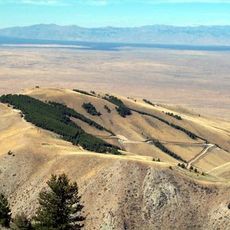
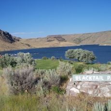
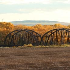
Hell's Half Acre Lava Field, Lava field in Bingham County, US.
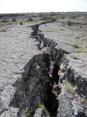
This basaltic formation spans 150 square miles across the Snake River Plain, featuring numerous volcanic formations including tubes, cracks, and cinder deposits.

The site received its name from fur traders in the early 19th century, and Benjamin Bonneville documented the area during his 1833 expedition.

The National Park Service designated the northwestern portion as a National Natural Landmark in 1976, recognizing its geological importance.

Visitors can access the area through maintained trails managed by the Bureau of Land Management, with seasonal closures during winter months.

The lava field contains ten circular pits and two large lava tubes near its summit, alongside a depression from a previous lava lake.

Location: Bingham County

Elevation above the sea: 1,432 m

GPS coordinates: 43.50000,-112.45000

Latest update: May 11, 2025 14:47

Rock formations and hoodoos for Instagram photos

Rock pillars and spires shaped by erosion stand as natural monuments across various locations worldwide. These geological structures, known as hoodoos, display different colors and shapes based on their mineral composition and environmental conditions. From the red rocks of Utah to the limestone formations of Turkey, these sites present geological formations created over millions of years through wind and water erosion. These formations develop through differential erosion, where softer rock layers erode faster than harder layers, leaving slender columns often capped with protective harder rock. Visitors find such structures in desert landscapes, canyons, and plateaus where conditions favor their formation and preservation. The color palette ranges from white to orange, red, and gray, depending on the minerals present such as iron oxide, limestone, or clay.

Around this place
Show the full map
Experimental Breeder Reactor I
United States of America

Experimental Breeder Reactor I

44.9 km
Fort Hall
United States of America

Fort Hall

55.5 km
Idaho Falls Idaho Temple
United States of America

Idaho Falls Idaho Temple

33 km
Idaho Potato Museum
United States of America

Idaho Potato Museum

35.6 km
Big Southern Butte
United States of America

Big Southern Butte

47.7 km
Rexburg Idaho Temple
United States of America

Rexburg Idaho Temple

64.2 km
Camas National Wildlife Refuge
United States of America

Camas National Wildlife Refuge

52.8 km
Ririe Reservoir
United States of America

Ririe Reservoir

57.9 km
Museum of Idaho
United States of America

Museum of Idaho

33.3 km
Mountain America Center
United States of America

Mountain America Center

31.1 km
Colonial Theatre
United States of America

Colonial Theatre

33 km
Blackfoot LDS Tabernacle
United States of America

Blackfoot LDS Tabernacle

35.9 km
First Presbyterian Church
United States of America

First Presbyterian Church

33.5 km
Idaho Falls Public Library
United States of America

Idaho Falls Public Library

33.4 km
Ririe A Pegram Truss Railroad Bridge
United States of America

Ririe A Pegram Truss Railroad Bridge

60.3 km
Bonneville County Courthouse
United States of America

Bonneville County Courthouse

33.1 km
United States Post Office–Blackfoot Main
United States of America

United States Post Office–Blackfoot Main

35.5 km
Idaho Falls City Building
United States of America

Idaho Falls City Building

33.3 km
Jefferson County Courthouse
United States of America

Jefferson County Courthouse

47.6 km
Ross Fork Episcopal Church
United States of America

Ross Fork Episcopal Church

35.6 km
I.O.O.F. Building
United States of America

I.O.O.F. Building

52.8 km
Blackfoot I.O.O.F. Hall
United States of America

Blackfoot I.O.O.F. Hall

35.6 km
Idaho Republican Building
United States of America

Idaho Republican Building

35.5 km
Shilling Avenue Historic District
United States of America

Shilling Avenue Historic District

35.9 km
Legacy Flight Museum
United States of America

Legacy Flight Museum

63.8 km
Iona Meetinghouse
United States of America

Iona Meetinghouse

42.2 km
Rexburg Spray Park
United States of America

Rexburg Spray Park

64 km
Funland at the Zoo
United States of America

Funland at the Zoo

33.2 km
Show the full map

Reviews

Visited this place? Tap the stars to rate it and share your experience / photos with the community! Try now! You can cancel it anytime.

« Hell's Half Acre Lava Field: Lava field in Bingham County, US » is provided by Around Us (aroundus.com). Images and texts are derived from Wikimedia project under a Creative Commons license. You are allowed to copy, distribute, and modify copies of this page, under the conditions set by the license, as long as this note is clearly visible.

Discover hidden gems everywhere you go!

From secret cafés to breathtaking viewpoints, skip the crowded tourist spots and find places that match your style. Our app makes it easy with voice search, smart filtering, route optimization, and insider tips from travelers worldwide. Download now for the complete mobile experience.

Around Us App Screenshot

A unique approach to discovering new places

Le Figaro

All the places worth exploring

France Info

A tailor-made excursion in just a few clicks

20 Minutes