·

Enable Location

We need your location to show you interesting places around you

Discover nearby places

Find interesting locations and hidden gems around you

Precise directions

Get accurate directions and distances to places

Your location is never shared with other users. It's only used when you tap the location button.

Camas National Wildlife Refuge

Log in to your account

Start exploring — it's free

Trusted by 62,630 travelers worldwide

Continue with Google
Continue with Apple
or

We will send you a code to connect

By continuing, you accept our Terms and Conditions and our Privacy Policy

Check your inbox

We've sent a pincode in your inbox. Please enter the code below.

Camas National Wildlife Refuge

Camas National Wildlife Refuge, National Wildlife Refuge in southeastern Idaho, United States

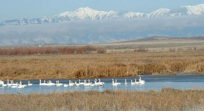
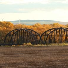
Camas National Wildlife Refuge is a protected area in southeastern Idaho featuring a mix of lakes, ponds, marshes, and grasslands divided by waterways. The landscape combines open water, wetland areas, and upland terrain that support diverse wildlife populations.

The refuge was established in 1937 to protect waterfowl and provide rest stops for migrating ducks and geese. Management efforts have focused on maintaining conditions that support these bird populations throughout the year.

The refuge serves as an observation point for wildlife photographers and bird enthusiasts who document various species throughout the seasons.

The refuge can be reached from Interstate 15 at Exit 150 near Hamer by heading north on local roads. Visitors should plan to explore on foot or by car along designated routes to observe wildlife effectively.

The refuge becomes a gathering point for large flocks of migratory birds that pass through during specific seasons of the year. These seasonal movements transform the area into a dynamic place where bird activity is especially concentrated and visible.

The community of curious travelers

AroundUs brings together thousands of curated places, local tips, and hidden gems, enriched daily by 60,000 contributors worldwide.

Start exploring
Location
Inception
1937
GPS coordinates
43.95130,-112.24900
Latest update
December 12, 2025 09:08
Around this place
Idaho Falls Idaho Temple
United States of America

Idaho Falls Idaho Temple

53 km
Hell's Half Acre Lava Field
United States of America

Hell's Half Acre Lava Field

52.8 km
Rexburg Idaho Temple
United States of America

Rexburg Idaho Temple

40.8 km
Monida Pass
United States of America

Monida Pass

67.8 km
Ririe Reservoir
United States of America

Ririe Reservoir

57.9 km
Museum of Idaho
United States of America

Museum of Idaho

54 km
Mountain America Center
United States of America

Mountain America Center

54.4 km
Rexburg Stake Tabernacle
United States of America

Rexburg Stake Tabernacle

39.8 km
South Fremont High School
United States of America

South Fremont High School

45.3 km
Colonial Theatre
United States of America

Colonial Theatre

53.7 km
Camas Meadows Battle Sites
United States of America

Camas Meadows Battle Sites

56.6 km
Bishop Mountain Lookout
United States of America

Bishop Mountain Lookout

70 km
First Presbyterian Church
United States of America

First Presbyterian Church

54.2 km
Idaho Falls Public Library
United States of America

Idaho Falls Public Library

54.1 km
St. Anthony Pegram Truss Railroad Bridge
United States of America

St. Anthony Pegram Truss Railroad Bridge

42.7 km
Ririe A Pegram Truss Railroad Bridge
United States of America

Ririe A Pegram Truss Railroad Bridge

51.9 km
Jacob Spori Building
United States of America

Jacob Spori Building

40.2 km
Fremont County Courthouse
United States of America

Fremont County Courthouse

45.3 km
Bonneville County Courthouse
United States of America

Bonneville County Courthouse

53.5 km
Independent Order of Odd Fellows Hall
United States of America

Independent Order of Odd Fellows Hall

65.6 km
Idaho Falls City Building
United States of America

Idaho Falls City Building

53.7 km
Jefferson County Courthouse
United States of America

Jefferson County Courthouse

41.2 km
I.O.O.F. Building
United States of America

I.O.O.F. Building

18.3 km
Madison County Courthouse
United States of America

Madison County Courthouse

40.3 km
Legacy Flight Museum
United States of America

Legacy Flight Museum

37.8 km
Iona Meetinghouse
United States of America

Iona Meetinghouse

53.6 km
St. Anthony Sand Dunes
United States of America

St. Anthony Sand Dunes

37.7 km
Virginia Theatre
United States of America

Virginia Theatre

64.3 km
Show the full map
« Camas National Wildlife Refuge - National Wildlife Refuge in southeastern Idaho, United States » is provided by Around Us (aroundus.com). Images and texts are derived from Wikimedia project under a Creative Commons license. You are allowed to copy, distribute, and modify copies of this page, under the conditions set by the license, as long as this note is clearly visible.

Discover hidden gems everywhere you go!

From secret cafés to breathtaking viewpoints, skip the crowded tourist spots and find places that match your style. Our app makes it easy with voice search, smart filtering, route optimization, and insider tips from travelers worldwide. Download now for the complete mobile experience.

Around Us App Screenshot

A unique approach to discovering new places

Le Figaro

All the places worth exploring

France Info

A tailor-made excursion in just a few clicks

20 Minutes

Around Us
Travel Guide & Maps
Download

Send to your phone

QR Code
1

Open the camera app on your mobile.

2

Point at the QR code with your camera. A notification will appear.

3

Tap the notification to open the link.