Enable Location

We need your location to show you interesting places around you

Discover nearby places

Find interesting locations and hidden gems around you

Precise directions

Get accurate directions and distances to places

Your location is never shared with other users. It's only used when you tap the location button.

Camas Meadows Battle Sites

Log in to your account

Start exploring — it's free

Trusted by 62,624 travelers worldwide

Continue with Google
Continue with Apple
or

We will send you a code to connect

By continuing, you accept our Terms and Conditions and our Privacy Policy

Check your inbox

We've sent a pincode in your inbox. Please enter the code below.

Camas Meadows Battle Sites, Historical battlefield in Clark County, United States.

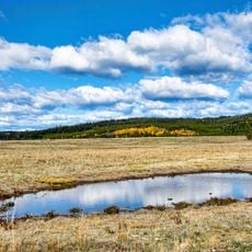
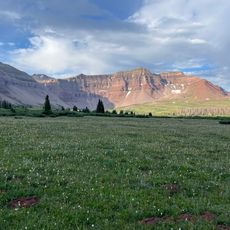
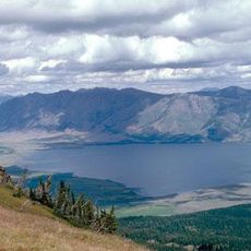
Camas Meadows Battle Sites are two separate battlefields in Clark County with defensive structures still visible across the landscape. Rifle pits dug by soldiers remain near the creeks where the fighting took place.

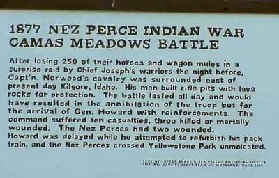
In August 1877, Nez Perce warriors carried out a successful raid against General Howard's troops, seizing a large herd of horses and mules. This victory was a significant moment in their larger struggle for freedom during their final resistance.

The place marks a turning point in the Nez Perce struggle against forced relocation policies. The battles reflect how this community resisted government control and fought to maintain their way of life.

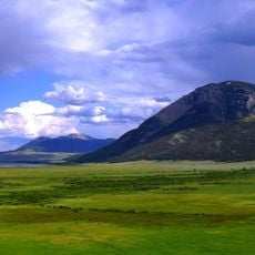
The two sites lie northeast of Dubois, Idaho and can be reached by car followed by walking across open terrain. Wear sturdy footwear since the ground is uneven and scattered with prairie grass and creeks.

The rifle pits visible today reveal the exact defensive positions dug by soldiers under Captain Norwood during the siege. These original earthworks let visitors stand where defenders once prepared for battle over a century ago.

The community of curious travelers

AroundUs brings together thousands of curated places, local tips, and hidden gems, enriched daily by 60,000 contributors worldwide.

Start exploring
Location
GPS coordinates
44.39806,-111.91139
Latest update
December 14, 2025 12:26
Around this place
Huckleberry Ridge Tuff
United States of America

Huckleberry Ridge Tuff

46.9 km
Island Park Caldera
United States of America

Island Park Caldera

46.9 km
Henry's Fork Caldera
United States of America

Henry's Fork Caldera

46.9 km
Mesa Falls Tuff
United States of America

Mesa Falls Tuff

46.9 km
Henrys Lake
United States of America

Henrys Lake

48.6 km
Upper Mesa Falls
United States of America

Upper Mesa Falls

51.9 km
Monida Pass
United States of America

Monida Pass

36.1 km
Big Springs
United States of America

Big Springs

53.4 km
Red Rock Lakes National Wildlife Refuge
United States of America

Red Rock Lakes National Wildlife Refuge

24.7 km
Camas National Wildlife Refuge
United States of America

Camas National Wildlife Refuge

56.6 km
Lower Mesa Falls
United States of America

Lower Mesa Falls

53.7 km
Rexburg Stake Tabernacle
United States of America

Rexburg Stake Tabernacle

64.3 km
South Fremont High School
United States of America

South Fremont High School

50.5 km
Johnny Sack Cabin
United States of America

Johnny Sack Cabin

53.4 km
Bishop Mountain Lookout
United States of America

Bishop Mountain Lookout

29.4 km
St. Anthony Pegram Truss Railroad Bridge
United States of America

St. Anthony Pegram Truss Railroad Bridge

52.2 km
Conant Creek Pegram Truss Railroad Bridge
United States of America

Conant Creek Pegram Truss Railroad Bridge

61 km
Fremont County Courthouse
United States of America

Fremont County Courthouse

51.2 km
Rexburg Rapids
United States of America

Rexburg Rapids

63.8 km
Independent Order of Odd Fellows Hall
United States of America

Independent Order of Odd Fellows Hall

52.8 km
I.O.O.F. Building
United States of America

I.O.O.F. Building

59.3 km
Hutchins Bridge
United States of America

Hutchins Bridge

60.6 km
Madison County Courthouse
United States of America

Madison County Courthouse

64.5 km
Legacy Flight Museum
United States of America

Legacy Flight Museum

63.3 km
Rankin Motel
United States of America

Rankin Motel

51.5 km
Rexburg Spray Park
United States of America

Rexburg Spray Park

64.8 km
St. Anthony Sand Dunes
United States of America

St. Anthony Sand Dunes

43.8 km
Targhee Lanes
United States of America

Targhee Lanes

51.2 km
Show the full map
« Camas Meadows Battle Sites - Historical battlefield in Clark County, United States » is provided by Around Us (aroundus.com). Images and texts are derived from Wikimedia project under a Creative Commons license. You are allowed to copy, distribute, and modify copies of this page, under the conditions set by the license, as long as this note is clearly visible.

Discover hidden gems everywhere you go!

From secret cafés to breathtaking viewpoints, skip the crowded tourist spots and find places that match your style. Our app makes it easy with voice search, smart filtering, route optimization, and insider tips from travelers worldwide. Download now for the complete mobile experience.

Around Us App Screenshot

A unique approach to discovering new places

Le Figaro

All the places worth exploring

France Info

A tailor-made excursion in just a few clicks

20 Minutes

Around Us
Travel Guide & Maps
Download

Send to your phone

QR Code
1

Open the camera app on your mobile.

2

Point at the QR code with your camera. A notification will appear.

3

Tap the notification to open the link.