Jug Rock

Log in to your account

AroundUs is a community-driven map of interesting places, built by curious explorers like you. It grows with every review, story, and photo you share.
Connect to save your favorite spots, contribute locations, and create personalized routes.
By continuing, you accept our Terms and Conditions and our Privacy Policy
Add to collection
Map
Suggest a change
Share

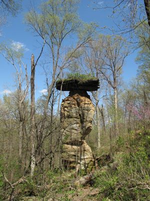
Jug Rock, Rock formation in Shoals, Indiana, US.

Jug Rock is a sandstone formation with a flat top layer resembling a stopper, standing approximately 42 feet (13 meters) high above the surrounding landscape. Natural erosion has created distinct layers and patterns throughout the stone, making its geological makeup visible.

State Geologist E. T. Cox documented this formation in 1871 through the Second Report of the Geological Survey of Indiana, recognizing its geological importance. His work helped establish the site as a significant feature in the region's geology.

The local high school sports teams are called the Jug Rox, with a mascot named Roxer Boxer inspired by this rock. The formation has become part of the community's identity and is referenced in local traditions.

Access is via Highway 50 west of Shoals, where a small gravel road leads to the formation. Visitors should wear comfortable shoes and be prepared for uneven ground when exploring the site on foot.

This sandstone structure is the largest free-standing table rock formation east of the Mississippi River in the United States. This exceptional scale and the rarity of such rock formations in this region make it a remarkable geological feature.

Location: Indiana

GPS coordinates: 38.68330,-86.80000

Latest update: December 6, 2025 17:40

Photos
Rock formations and hoodoos for Instagram photos

Rock pillars and spires shaped by erosion stand as natural monuments across various locations worldwide. These geological structures, known as hoodoos, display different colors and shapes based on their mineral composition and environmental conditions. From the red rocks of Utah to the limestone formations of Turkey, these sites present geological formations created over millions of years through wind and water erosion. These formations develop through differential erosion, where softer rock layers erode faster than harder layers, leaving slender columns often capped with protective harder rock. Visitors find such structures in desert landscapes, canyons, and plateaus where conditions favor their formation and preservation. The color palette ranges from white to orange, red, and gray, depending on the minerals present such as iron oxide, limestone, or clay.

Around this place
Show the full map
Patoka Lake
United States of America

Patoka Lake

28.8 km
French Lick Springs Hotel
United States of America

French Lick Springs Hotel

21.5 km
Bluespring Caverns
United States of America

Bluespring Caverns

25.4 km
Indiana Railway Museum
United States of America

Indiana Railway Museum

21.4 km
Williams Bridge
United States of America

Williams Bridge

17.3 km
Homestead Hotel
United States of America

Homestead Hotel

20.8 km
Prairie Creek Site
United States of America

Prairie Creek Site

32 km
First Baptist Church
United States of America

First Baptist Church

21 km
Orange County Courthouse
United States of America

Orange County Courthouse

32.1 km
Mitchell Opera House
United States of America

Mitchell Opera House

28.9 km
Evangelische Lutherische Emanuels Kirche
United States of America

Evangelische Lutherische Emanuels Kirche

24.2 km
Lemmon Presbyterian Church
United States of America

Lemmon Presbyterian Church

30 km
Mitchell Downtown Historic District
United States of America

Mitchell Downtown Historic District

28.8 km
West Baden National Bank
United States of America

West Baden National Bank

20.7 km
Martin County Courthouse
United States of America

Martin County Courthouse

1.5 km
Thomas Newby Braxtan House
United States of America

Thomas Newby Braxtan House

32.1 km
Dixie Garage
United States of America

Dixie Garage

20.9 km
Thomas Faith House
United States of America

Thomas Faith House

31.5 km
Dr. John A. Scudder House
United States of America

Dr. John A. Scudder House

32.1 km
Jenkins Place
United States of America

Jenkins Place

30.8 km
Paoli Historic District
United States of America

Paoli Historic District

32.1 km
Orleans Historic District
United States of America

Orleans Historic District

30.3 km
Newberry Friends Meeting House
United States of America

Newberry Friends Meeting House

29.2 km
FLWB Indoor Karting
United States of America

FLWB Indoor Karting

21.3 km
French Lick West Baden Museum
United States of America

French Lick West Baden Museum

21.6 km
Mitchell City Pool
United States of America

Mitchell City Pool

27.8 km
Lindley House
United States of America

Lindley House

30.7 km
Gospel Street Bridge
United States of America

Gospel Street Bridge

32.2 km
Show the full map
Reviews

Visited this place? Tap the stars to rate it and share your experience / photos with the community! Try now! You can cancel it anytime.

« Jug Rock - Rock formation in Shoals, Indiana, US » is provided by Around Us (aroundus.com). Images and texts are derived from Wikimedia project under a Creative Commons license. You are allowed to copy, distribute, and modify copies of this page, under the conditions set by the license, as long as this note is clearly visible.

Discover hidden gems everywhere you go!

From secret cafés to breathtaking viewpoints, skip the crowded tourist spots and find places that match your style. Our app makes it easy with voice search, smart filtering, route optimization, and insider tips from travelers worldwide. Download now for the complete mobile experience.

Around Us App Screenshot

A unique approach to discovering new places

Le Figaro

All the places worth exploring

France Info

A tailor-made excursion in just a few clicks

20 Minutes