Enable Location

We need your location to show you interesting places around you

Discover nearby places

Find interesting locations and hidden gems around you

Precise directions

Get accurate directions and distances to places

Your location is never shared with other users. It's only used when you tap the location button.

Prairie Creek Site

Log in to your account

Start exploring — it's free

Trusted by 62,127 travelers worldwide

Continue with Google
Continue with Apple
or

We will send you a code to connect

By continuing, you accept our Terms and Conditions and our Privacy Policy

Check your inbox

We've sent a pincode in your inbox. Please enter the code below.

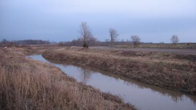
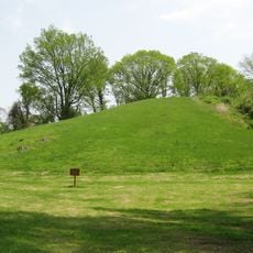
Prairie Creek Site, Archaeological site near Prairie Creek in Daviess County, United States.

Prairie Creek Site is an archaeological location spanning 30 acres along the southern bank of Prairie Creek in Daviess County. The site contains fifteen distinct soil layers filled with stone tools, animal bones, and preserved organic remains that show continuous human use over long periods.

Excavations began in 1972 when mastodon bones were discovered, prompting systematic research by Indiana University Bloomington. These investigations revealed evidence of human settlement in the area stretching back through multiple time periods.

The site gets its name from the nearby creek and reflects how Indigenous peoples used this location for hunting and daily tasks. Bone remains and stone tools scattered across the layers show the rhythms of life in this region thousands of years ago.

Some areas of the site require advance permission from local authorities before visiting, particularly where active research is underway. Plan your visit for dry weather conditions, as wet ground can make walking difficult and may limit access to certain zones.

Layer seven contains a carefully made bone fishhook alongside flint flakes and fish remains, offering rare evidence of how people engineered tools for water hunting. This combination reveals specific techniques that ancient inhabitants used to catch and process food from the creek.

The community of curious travelers

AroundUs brings together thousands of curated places, local tips, and hidden gems, enriched daily by 60,000 contributors worldwide.

Start exploring
Location
GPS coordinates
38.71780,-87.16530
Latest update
December 14, 2025 16:42
Around this place
Grouseland
United States of America

Grouseland

31.5 km
George Rogers Clark National Historical Park
United States of America

George Rogers Clark National Historical Park

32.5 km
Forts of Vincennes
United States of America

Forts of Vincennes

32.5 km
Jug Rock
United States of America

Jug Rock

32 km
St. Francis Xavier Cathedral and Library
United States of America

St. Francis Xavier Cathedral and Library

32.3 km
Lincoln Memorial Bridge
United States of America

Lincoln Memorial Bridge

32.4 km
Pyramid Mound
United States of America

Pyramid Mound

30.1 km
Indiana Territorial Capitol
United States of America

Indiana Territorial Capitol

31.5 km
Shadowwood
United States of America

Shadowwood

22.1 km
Robert C. Graham House
United States of America

Robert C. Graham House

6.3 km
Dr. Nelson Wilson House
United States of America

Dr. Nelson Wilson House

7.3 km
Vincennes Fortnightly Club
United States of America

Vincennes Fortnightly Club

31.6 km
Old State Bank
United States of America

Old State Bank

32 km
Hack and Simon Office Building
United States of America

Hack and Simon Office Building

31.1 km
County Bridge No. 45
United States of America

County Bridge No. 45

10.2 km
Lemmon Presbyterian Church
United States of America

Lemmon Presbyterian Church

27.4 km
Martin County Courthouse
United States of America

Martin County Courthouse

32.4 km
Daviess County Courthouse
United States of America

Daviess County Courthouse

6.6 km
Magnus J. Carnahan House
United States of America

Magnus J. Carnahan House

6.8 km
Thomas Faith House
United States of America

Thomas Faith House

6.4 km
Dr. John A. Scudder House
United States of America

Dr. John A. Scudder House

6.7 km
Washington Commercial Historic District
United States of America

Washington Commercial Historic District

6.7 km
Pike County Courthouse
United States of America

Pike County Courthouse

27.1 km
Indiana Military Museum
United States of America

Indiana Military Museum

32.7 km
Alfred Simonson House
United States of America

Alfred Simonson House

12.7 km
The Red Skelton Museum of American Comedy
United States of America

The Red Skelton Museum of American Comedy

30.8 km
Harrison Mansion
United States of America

Harrison Mansion

31.5 km
Black Creek Bridge
United States of America

Black Creek Bridge

33.5 km
Show the full map
« Prairie Creek Site - Archaeological site near Prairie Creek in Daviess County, United States » is provided by Around Us (aroundus.com). Images and texts are derived from Wikimedia project under a Creative Commons license. You are allowed to copy, distribute, and modify copies of this page, under the conditions set by the license, as long as this note is clearly visible.

Discover hidden gems everywhere you go!

From secret cafés to breathtaking viewpoints, skip the crowded tourist spots and find places that match your style. Our app makes it easy with voice search, smart filtering, route optimization, and insider tips from travelers worldwide. Download now for the complete mobile experience.

Around Us App Screenshot

A unique approach to discovering new places

Le Figaro

All the places worth exploring

France Info

A tailor-made excursion in just a few clicks

20 Minutes

Around Us
Travel Guide & Maps
Download

Send to your phone

QR Code
1

Open the camera app on your mobile.

2

Point at the QR code with your camera. A notification will appear.

3

Tap the notification to open the link.