·

Enable Location

We need your location to show you interesting places around you

Discover nearby places

Find interesting locations and hidden gems around you

Precise directions

Get accurate directions and distances to places

Your location is never shared with other users. It's only used when you tap the location button.

Lincoln Memorial Bridge

Log in to your account

Start exploring — it's free

Trusted by 62,722 travelers worldwide

Continue with Google
Continue with Apple
or

We will send you a code to connect

By continuing, you accept our Terms and Conditions and our Privacy Policy

Check your inbox

We've sent a pincode in your inbox. Please enter the code below.

Lincoln Memorial Bridge

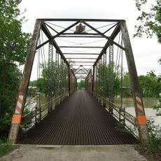
Lincoln Memorial Bridge, Road bridge between Vincennes, Indiana and Lawrence County, United States.

Lincoln Memorial Bridge is a road bridge spanning the Wabash River with reinforced concrete construction and an open-spandrel arch design. It carries U.S. Route 50 Business between Indiana and Illinois, featuring a 22-foot-wide roadway for vehicle traffic.

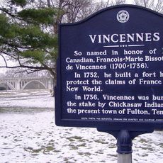
The bridge marks the location where Abraham Lincoln and his family crossed the Wabash River during their migration from Indiana to Illinois in 1830. This passage became a defining moment in the region's connection to Lincoln's early life and journey west.

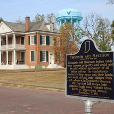
Granite pylons at the bridge entrances feature relief sculptures of Native American leaders Tecumseh and The Prophet, created by French artist Raoul Josset. These monuments honor the region's indigenous heritage and mark the crossing as a place of historical memory.

The bridge carries traffic on a single roadway, so expect moderate congestion during peak times, particularly for larger vehicles or heavy traffic periods. It remains open year-round and is easily accessible from U.S. Route 50 Business.

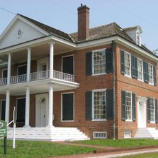
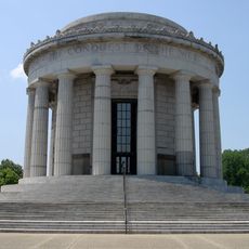
The bridge sits adjacent to the George Rogers Clark National Historical Park, where visitors can explore related monuments and historical sites. This proximity links Lincoln's passage to the broader context of early American history in the region.

The community of curious travelers

AroundUs brings together thousands of curated places, local tips, and hidden gems, enriched daily by 60,000 contributors worldwide.

Start exploring
Location
Location
Inception
September 3, 1933
Official opening
September 3, 1933
GPS coordinates
38.68170,-87.53530
Latest update
December 12, 2025 12:03
Around this place
Grouseland
United States of America

Grouseland

911 m
George Rogers Clark National Historical Park
United States of America

George Rogers Clark National Historical Park

281 m
Forts of Vincennes
United States of America

Forts of Vincennes

280 m
St. Francis Xavier Cathedral and Library
United States of America

St. Francis Xavier Cathedral and Library

328 m
Pyramid Mound
United States of America

Pyramid Mound

2.8 km
Red Hills State Park
United States of America

Red Hills State Park

26.6 km
Indiana Territorial Capitol
United States of America

Indiana Territorial Capitol

945 m
Prairie Creek Site
United States of America

Prairie Creek Site

32.4 km
Shadowwood
United States of America

Shadowwood

10.4 km
Robert C. Graham House
United States of America

Robert C. Graham House

31.1 km
Dr. Nelson Wilson House
United States of America

Dr. Nelson Wilson House

31.5 km
American Trust and Savings Bank
United States of America

American Trust and Savings Bank

32.5 km
Vincennes Fortnightly Club
United States of America

Vincennes Fortnightly Club

915 m
Bridge at Thirteenth Street
United States of America

Bridge at Thirteenth Street

14.3 km
Swan Island Site
United States of America

Swan Island Site

19 km
Old State Bank
United States of America

Old State Bank

377 m
Lawrence County Courthouse
United States of America

Lawrence County Courthouse

13.8 km
Hack and Simon Office Building
United States of America

Hack and Simon Office Building

1.3 km
County Bridge No. 45
United States of America

County Bridge No. 45

22.9 km
Daviess County Courthouse
United States of America

Daviess County Courthouse

31.6 km
Magnus J. Carnahan House
United States of America

Magnus J. Carnahan House

31.9 km
Dr. John A. Scudder House
United States of America

Dr. John A. Scudder House

32 km
Washington Commercial Historic District
United States of America

Washington Commercial Historic District

31.6 km
Pike County Courthouse
United States of America

Pike County Courthouse

30.8 km
Indiana Military Museum
United States of America

Indiana Military Museum

907 m
Alfred Simonson House
United States of America

Alfred Simonson House

28.8 km
The Red Skelton Museum of American Comedy
United States of America

The Red Skelton Museum of American Comedy

1.8 km
Harrison Mansion
United States of America

Harrison Mansion

926 m
Show the full map
« Lincoln Memorial Bridge - Road bridge between Vincennes, Indiana and Lawrence County, United States » is provided by Around Us (aroundus.com). Images and texts are derived from Wikimedia project under a Creative Commons license. You are allowed to copy, distribute, and modify copies of this page, under the conditions set by the license, as long as this note is clearly visible.

Discover hidden gems everywhere you go!

From secret cafés to breathtaking viewpoints, skip the crowded tourist spots and find places that match your style. Our app makes it easy with voice search, smart filtering, route optimization, and insider tips from travelers worldwide. Download now for the complete mobile experience.

Around Us App Screenshot

A unique approach to discovering new places

Le Figaro

All the places worth exploring

France Info

A tailor-made excursion in just a few clicks

20 Minutes

Around Us
Travel Guide & Maps
Download

Send to your phone

QR Code
1

Open the camera app on your mobile.

2

Point at the QR code with your camera. A notification will appear.

3

Tap the notification to open the link.