·

Enable Location

We need your location to show you interesting places around you

Discover nearby places

Find interesting locations and hidden gems around you

Precise directions

Get accurate directions and distances to places

Your location is never shared with other users. It's only used when you tap the location button.

Shadowwood

Log in to your account

Start exploring — it's free

Trusted by 62,715 travelers worldwide

Continue with Google
Continue with Apple
or

We will send you a code to connect

By continuing, you accept our Terms and Conditions and our Privacy Policy

Check your inbox

We've sent a pincode in your inbox. Please enter the code below.

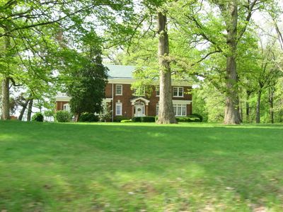
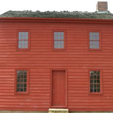
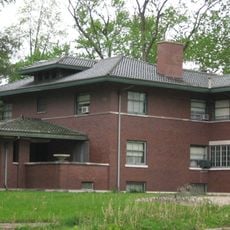
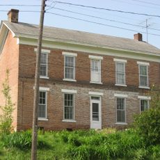
Shadowwood, Colonial Revival estate in Palmyra Township, Knox County, Indiana, United States.

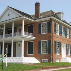
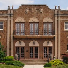
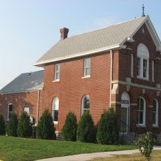
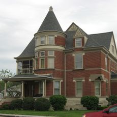
Shadowwood is a two-and-a-half-story brick building in Palmyra Township, Knox County, Indiana, that features a side-gabled tile roof and a prominent two-story columned portico on its south-facing facade. A second-story sleeping porch extends across the southern wall, creating an additional outdoor living space.

The house was built in 1917 for Colonel Eugene C. Wharf on property that was once part of the Rose Hill Farmstead, originally acquired from Robert B. Patterson. This land transfer marked the creation of the estate on ground with earlier agricultural use.

The property was known locally as Rebel Hill due to gatherings held there by the Knights of the Golden Circle in earlier decades, a name that reflected the forested landscape where the house would later be built. This historical connection to the land remains part of the local understanding of the place.

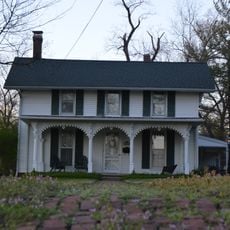
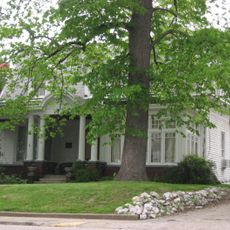
The property includes outbuildings from different periods, with a pump house and carriage house dating to 1917 alongside a chicken house built around 1945. Visitors can explore these additional structures as part of the overall grounds experience.

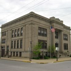
From 1963 to 2003, the property served as the international headquarters of Sigma Pi Fraternity after Vincennes University transferred the building to the organization. This decades-long use as a fraternity headquarters represented a significant chapter in its 20th-century life.

The community of curious travelers

AroundUs brings together thousands of curated places, local tips, and hidden gems, enriched daily by 60,000 contributors worldwide.

Start exploring
Location
GPS coordinates
38.69972,-87.41833
Latest update
December 14, 2025 17:41
Around this place
Grouseland
United States of America

Grouseland

9.5 km
George Rogers Clark National Historical Park
United States of America

George Rogers Clark National Historical Park

10.5 km
Forts of Vincennes
United States of America

Forts of Vincennes

10.4 km
St. Francis Xavier Cathedral and Library
United States of America

St. Francis Xavier Cathedral and Library

10.3 km
Lincoln Memorial Bridge
United States of America

Lincoln Memorial Bridge

10.4 km
Pyramid Mound
United States of America

Pyramid Mound

8.3 km
Indiana Territorial Capitol
United States of America

Indiana Territorial Capitol

9.4 km
Prairie Creek Site
United States of America

Prairie Creek Site

22.1 km
Robert C. Graham House
United States of America

Robert C. Graham House

21.3 km
Dr. Nelson Wilson House
United States of America

Dr. Nelson Wilson House

21.8 km
American Trust and Savings Bank
United States of America

American Trust and Savings Bank

33.1 km
Vincennes Fortnightly Club
United States of America

Vincennes Fortnightly Club

9.6 km
Bridge at Thirteenth Street
United States of America

Bridge at Thirteenth Street

23.6 km
Swan Island Site
United States of America

Swan Island Site

19.9 km
Old State Bank
United States of America

Old State Bank

10 km
Lawrence County Courthouse
United States of America

Lawrence County Courthouse

23.2 km
Hack and Simon Office Building
United States of America

Hack and Simon Office Building

9 km
County Bridge No. 45
United States of America

County Bridge No. 45

12.9 km
Daviess County Courthouse
United States of America

Daviess County Courthouse

21.8 km
Magnus J. Carnahan House
United States of America

Magnus J. Carnahan House

22.1 km
Thomas Faith House
United States of America

Thomas Faith House

22.8 km
Dr. John A. Scudder House
United States of America

Dr. John A. Scudder House

22.3 km
Washington Commercial Historic District
United States of America

Washington Commercial Historic District

21.9 km
Pike County Courthouse
United States of America

Pike County Courthouse

26.2 km
Indiana Military Museum
United States of America

Indiana Military Museum

10.8 km
Alfred Simonson House
United States of America

Alfred Simonson House

19.3 km
The Red Skelton Museum of American Comedy
United States of America

The Red Skelton Museum of American Comedy

8.7 km
Harrison Mansion
United States of America

Harrison Mansion

9.5 km
Show the full map
« Shadowwood - Colonial Revival estate in Palmyra Township, Knox County, Indiana, United States » is provided by Around Us (aroundus.com). Images and texts are derived from Wikimedia project under a Creative Commons license. You are allowed to copy, distribute, and modify copies of this page, under the conditions set by the license, as long as this note is clearly visible.

Discover hidden gems everywhere you go!

From secret cafés to breathtaking viewpoints, skip the crowded tourist spots and find places that match your style. Our app makes it easy with voice search, smart filtering, route optimization, and insider tips from travelers worldwide. Download now for the complete mobile experience.

Around Us App Screenshot

A unique approach to discovering new places

Le Figaro

All the places worth exploring

France Info

A tailor-made excursion in just a few clicks

20 Minutes

Around Us
Travel Guide & Maps
Download

Send to your phone

QR Code
1

Open the camera app on your mobile.

2

Point at the QR code with your camera. A notification will appear.

3

Tap the notification to open the link.