Enable Location

We need your location to show you interesting places around you

Discover nearby places

Find interesting locations and hidden gems around you

Precise directions

Get accurate directions and distances to places

Your location is never shared with other users. It's only used when you tap the location button.

Red Hills State Park

Log in to your account

Start exploring — it's free

Trusted by 60,645 travelers worldwide

Continue with Google
Continue with Apple
or

We will send you a code to connect

By continuing, you accept our Terms and Conditions and our Privacy Policy

Check your inbox

We've sent a pincode in your inbox. Please enter the code below.

Red Hills State Park

Red Hills State Park, State park in Lawrence County, Illinois

Description

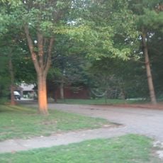
Red Hills State Park is a state park in Lawrence County that features varied landscapes including wooded hills, deep ravines, and open meadows. The park centers around a 40-acre lake that serves as the focal point for fishing, boating, and water-based recreation.

History

The land originated as part of the Vincennes Tract, which transferred to the United States in 1795 following treaties with Native American tribes. This early acquisition established the foundation for the area's eventual development into a public recreation space.

Culture

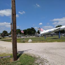
Within the park, Veterans' Point is a gathering place where military service groups honor those who served in past conflicts. The space reflects how the community maintains connections to veteran communities through remembrance.

Practical

The park offers more than 100 campsites with electrical hookups and facilities for hiking, fishing, and boating throughout the year. Visitors should come prepared for varying weather conditions since the grounds remain accessible across all seasons.

Did you know?

The park contains Chauncey Marsh Nature Preserve, which displays the Wabash Border Marsh Ecosystem with pink and white hibiscus blooming in late summer. This specialized wetland habitat attracts visitors interested in observing rare plant species and seasonal wildflower displays.

Location
Inception
1949
GPS coordinates
38.72970,-87.83560
Latest update
December 12, 2025 17:47

AroundUs brings together thousands of curated places, local tips, and hidden gems, enriched daily by 60,000 contributors worldwide. Discover all places nearby (Lawrence County).

Around this place
Grouseland
United States of America

Grouseland

27.3 km
George Rogers Clark National Historical Park
United States of America

George Rogers Clark National Historical Park

26.6 km
Forts of Vincennes
United States of America

Forts of Vincennes

26.7 km
St. Francis Xavier Cathedral and Library
United States of America

St. Francis Xavier Cathedral and Library

26.8 km
Lincoln Memorial Bridge
United States of America

Lincoln Memorial Bridge

26.6 km
Pyramid Mound
United States of America

Pyramid Mound

29.4 km
Indiana Territorial Capitol
United States of America

Indiana Territorial Capitol

27.4 km
Shadowwood
United States of America

Shadowwood

36.4 km
Ambrose Hopkinson House
United States of America

Ambrose Hopkinson House

21.7 km
American Trust and Savings Bank
United States of America

American Trust and Savings Bank

35.6 km
Vincennes Fortnightly Club
United States of America

Vincennes Fortnightly Club

27.5 km
Wabash County Courthouse
United States of America

Wabash County Courthouse

36.2 km
Elliott Street Historic District
United States of America

Elliott Street Historic District

21.2 km
Bridge at Thirteenth Street
United States of America

Bridge at Thirteenth Street

22 km
Swan Island Site
United States of America

Swan Island Site

29.3 km
Fife Opera House
United States of America

Fife Opera House

35.9 km
Old State Bank
United States of America

Old State Bank

27 km
Lawrence County Courthouse
United States of America

Lawrence County Courthouse

13.3 km
Olney Carnegie Library
United States of America

Olney Carnegie Library

21.3 km
Hack and Simon Office Building
United States of America

Hack and Simon Office Building

27.9 km
Larchmound
United States of America

Larchmound

21.4 km
Beall-Orr House
United States of America

Beall-Orr House

36 km
John B. Harper House
United States of America

John B. Harper House

36.1 km
Crawford County Courthouse
United States of America

Crawford County Courthouse

31.8 km
Indiana Military Museum
United States of America

Indiana Military Museum

26.6 km
Palestine Commercial Historic District
United States of America

Palestine Commercial Historic District

36 km
The Red Skelton Museum of American Comedy
United States of America

The Red Skelton Museum of American Comedy

28 km
Harrison Mansion
United States of America

Harrison Mansion

27.3 km
Show the full map
« Red Hills State Park - State park in Lawrence County, Illinois » is provided by Around Us (aroundus.com). Images and texts are derived from Wikimedia project under a Creative Commons license. You are allowed to copy, distribute, and modify copies of this page, under the conditions set by the license, as long as this note is clearly visible.

Discover hidden gems everywhere you go!

From secret cafés to breathtaking viewpoints, skip the crowded tourist spots and find places that match your style. Our app makes it easy with voice search, smart filtering, route optimization, and insider tips from travelers worldwide. Download now for the complete mobile experience.

Around Us App Screenshot

A unique approach to discovering new places

Le Figaro

All the places worth exploring

France Info

A tailor-made excursion in just a few clicks

20 Minutes

Around Us
Travel Guide & Maps
Download

Send to your phone

QR Code
1

Open the camera app on your mobile.

2

Point at the QR code with your camera. A notification will appear.

3

Tap the notification to open the link.