Enable Location

We need your location to show you interesting places around you

Discover nearby places

Find interesting locations and hidden gems around you

Precise directions

Get accurate directions and distances to places

Your location is never shared with other users. It's only used when you tap the location button.

Caprock Canyons State Park and Trailway

Log in to your account

Start exploring — it's free

Trusted by 62,875 travelers worldwide

Continue with Google
Continue with Apple
or

We will send you a code to connect

By continuing, you accept our Terms and Conditions and our Privacy Policy

Check your inbox

We've sent a pincode in your inbox. Please enter the code below.

Caprock Canyons State Park and Trailway

Caprock Canyons State Park and Trailway, State park in Briscoe County, United States.

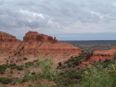
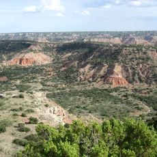
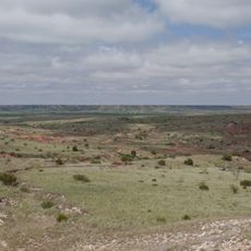
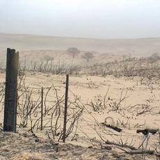
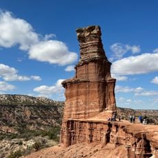
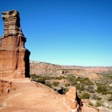
Caprock Canyons State Park and Trailway is a protected area in Briscoe County, Texas, covering a landscape of canyons and red rock plateaus. The grounds span several thousand acres and are crossed by trails for walking and cycling, partly following old railway routes.

The Texas park authority took over a disused railway line from the Fort Worth and Denver Railroad in 1993 and converted it into walking and cycling trails. This route now connects different sections of the park.

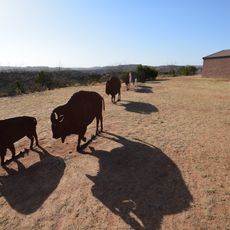
The name comes from the hard rock layer that gives the Caprock Escarpment its shape across the Texas Panhandle. A bison herd lives on the grounds today, and visitors see these animals while walking or cycling along the trails.

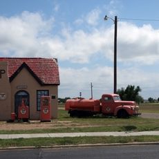
Access to the trails is through the town of Quitaque, roughly 3 miles south of the main entrance. Visitors use self-service stations at the entry and should bring plenty of water in warm weather.

A 19th-century railway tunnel cuts through a ridge and now forms part of the cycling route. This tunnel is more than 500 feet long and sits in one of the less traveled sections of the park.

The community of curious travelers

AroundUs brings together thousands of curated places, local tips, and hidden gems, enriched daily by 60,000 contributors worldwide.

Start exploring
Location
Inception
1982
Official opening
1982
Elevation above the sea
743 m
GPS coordinates
34.44360,-101.05200
Latest update
December 5, 2025 22:31
Hidden places in Texas

Texas combines landscapes that barely resemble each other. The west spreads out in deserts and sand dunes, while the east is marked by swamps and dense forests. Between these extremes lie limestone cliffs, natural springs, and waterfalls that bubble up from the ground. The size of the state allows...

Rock formations and hoodoos for Instagram photos

Rock pillars and spires shaped by erosion stand as natural monuments across various locations worldwide. These geological structures, known as hoodoos, display different colors and shapes based on their mineral composition and environmental conditions. From the red rocks of Utah to the limestone...

Around this place
Palo Duro Canyon
United States of America

Palo Duro Canyon

79.7 km
JA Ranch
United States of America

JA Ranch

43.4 km
Santa's Village
United States of America

Santa's Village

1480.6 km
Blanco Canyon
United States of America

Blanco Canyon

95.6 km
Leaning Tower of Britten
United States of America

Leaning Tower of Britten

84 km
Panhandle–Plains Historical Museum
United States of America

Panhandle–Plains Historical Museum

99.2 km
McClellan Creek National Grassland
United States of America

McClellan Creek National Grassland

87 km
Mt. Blanco Fossil Museum
United States of America

Mt. Blanco Fossil Museum

88.9 km
Devils Rope Barbed Wire Museum
United States of America

Devils Rope Barbed Wire Museum

97.1 km
Hotel Turkey
United States of America

Hotel Turkey

15.2 km
Charles and Mary Ann Goodnight Ranch House
United States of America

Charles and Mary Ann Goodnight Ranch House

66.4 km
Cruz Gigante de Groom
United States of America

Cruz Gigante de Groom

85.5 km
Donley County Courthouse and Jail
United States of America

Donley County Courthouse and Jail

56.9 km
Dickens County Courthouse and Jail
United States of America

Dickens County Courthouse and Jail

93.7 km
Hall County Courthouse
United States of America

Hall County Courthouse

56.8 km
Lake Theo
United States of America

Lake Theo

3.4 km
Devil's Rope Museum
United States of America

Devil's Rope Museum

97 km
Palo Duro State Park
United States of America

Palo Duro State Park

78.1 km
Ritz Theatre
United States of America

Ritz Theatre

89.4 km
Hale County Courthouse
United States of America

Hale County Courthouse

66.4 km
Lighthouse Peak
United States of America

Lighthouse Peak

80.6 km
Randall County Courthouse
United States of America

Randall County Courthouse

99.9 km
Childress County Heritage Museum
United States of America

Childress County Heritage Museum

77.5 km
Texas Outdoor Musical
United States of America

Texas Outdoor Musical

82.5 km
Cottle County Courthouse
United States of America

Cottle County Courthouse

84 km
McLean Commercial Historic District
United States of America

McLean Commercial Historic District

97 km
Phillips 66 Station (McLean, Texas)
United States of America

Phillips 66 Station (McLean, Texas)

97 km
Overlook Interpretive Center
United States of America

Overlook Interpretive Center

2.7 km
Show the full map
« Caprock Canyons State Park and Trailway - State park in Briscoe County, United States » is provided by Around Us (aroundus.com). Images and texts are derived from Wikimedia project under a Creative Commons license. You are allowed to copy, distribute, and modify copies of this page, under the conditions set by the license, as long as this note is clearly visible.

Discover hidden gems everywhere you go!

From secret cafés to breathtaking viewpoints, skip the crowded tourist spots and find places that match your style. Our app makes it easy with voice search, smart filtering, route optimization, and insider tips from travelers worldwide. Download now for the complete mobile experience.

Around Us App Screenshot

A unique approach to discovering new places

Le Figaro

All the places worth exploring

France Info

A tailor-made excursion in just a few clicks

20 Minutes

Around Us
Travel Guide & Maps
Download

Send to your phone

QR Code
1

Open the camera app on your mobile.

2

Point at the QR code with your camera. A notification will appear.

3

Tap the notification to open the link.