Enable Location

We need your location to show you interesting places around you

Discover nearby places

Find interesting locations and hidden gems around you

Precise directions

Get accurate directions and distances to places

Your location is never shared with other users. It's only used when you tap the location button.

Leaning Tower of Britten

Log in to your account

Start exploring — it's free

Trusted by 66,649 travelers worldwide

Continue with Google
Continue with Apple
or

We will send you a code to connect

By continuing, you accept our Terms and Conditions and our Privacy Policy

Check your inbox

We've sent a pincode in your inbox. Please enter the code below.

Leaning Tower of Britten
Discussion Reviews 1 Photos
7.4k Popularity

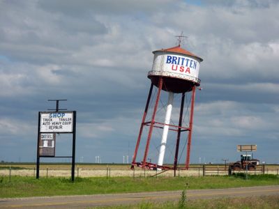
Leaning Tower of Britten, Water tower in Groom, Texas, United States.

The Leaning Tower of Britten is a tilted water tower located near Groom, Texas, beside Interstate 40, leaning at roughly a 10-degree angle and topped with a large colored star. It sits on a gravel lot that is visible from the highway in both directions.

In the 1980s, Ralph Britten bought this water tower before it could be torn down and had it moved to its current spot. He placed it there to draw attention to a nearby truck stop and visitor center.

The tower stands along a stretch of old Route 66 and belongs to a long tradition of roadside stops that invite travelers to pull over and look. Many visitors photograph it from the road and see it as a marker of an older way of traveling across America.

The tower is reached by a short gravel road with enough space to park, including room for larger vehicles. Since it is easy to spot from Interstate 40, a quick stop is all you need to see it up close.

The tower was placed at its angle on purpose and did not lean over time due to age or ground shifts. The tilt is a deliberate design choice, not a sign of damage or wear.

The community of curious travelers

AroundUs brings together thousands of curated places, local tips, and hidden gems, enriched daily by 60,000 contributors worldwide.

Start exploring
Location
GPS coordinates
35.19816,-101.08190
Latest update
March 3, 2026 10:12
Around this place
Palo Duro Canyon
United States of America

Palo Duro Canyon

60 km
Lake Meredith
United States of America

Lake Meredith

71.6 km
JA Ranch
United States of America

JA Ranch

43.5 km
Woo Cheong Pawn Shop
China

Woo Cheong Pawn Shop

53.9 km
Amarillo Civic Center
United States of America

Amarillo Civic Center

68.2 km
Atchison, Topeka and Santa Fe Railway 5000
United States of America

Atchison, Topeka and Santa Fe Railway 5000

68.1 km
Amarillo National Bank Sox Stadium
United States of America

Amarillo National Bank Sox Stadium

65.3 km
McClellan Creek National Grassland
United States of America

McClellan Creek National Grassland

19.4 km
Fort Elliott
United States of America

Fort Elliott

67 km
Devils Rope Barbed Wire Museum
United States of America

Devils Rope Barbed Wire Museum

44.3 km
Texas Air & Space Museum
United States of America

Texas Air & Space Museum

56.3 km
Charles and Mary Ann Goodnight Ranch House
United States of America

Charles and Mary Ann Goodnight Ranch House

20.8 km
Carson County Square House Museum
United States of America

Carson County Square House Museum

31.8 km
Cruz Gigante de Groom
United States of America

Cruz Gigante de Groom

4 km
Donley County Courthouse and Jail
United States of America

Donley County Courthouse and Jail

33.9 km
Gray County Courthouse
United States of America

Gray County Courthouse

39.2 km
Pampa H2O Aquatic Center
United States of America

Pampa H2O Aquatic Center

40.4 km
Devil's Rope Museum
United States of America

Devil's Rope Museum

44.2 km
Pampa City Hall
United States of America

Pampa City Hall

39.1 km
Freedom Museum USA
United States of America

Freedom Museum USA

39.1 km
Palo Duro State Park
United States of America

Palo Duro State Park

60.6 km
Llano Cemetery
United States of America

Llano Cemetery

67.8 km
Morley Theatre
United States of America

Morley Theatre

59.8 km
Lighthouse Peak
United States of America

Lighthouse Peak

63.2 km
White Deer Land Company Building
United States of America

White Deer Land Company Building

39.1 km
Texas Outdoor Musical
United States of America

Texas Outdoor Musical

59.8 km
McLean Commercial Historic District
United States of America

McLean Commercial Historic District

44 km
Phillips 66 Station (McLean, Texas)
United States of America

Phillips 66 Station (McLean, Texas)

43.8 km
Show the full map
Reviews
Share your experience

No review yet

Discussions
Start a discussion...

No discussion yet

« Leaning Tower of Britten - Water tower in Groom, Texas, United States » is provided by Around Us (aroundus.com). Images and texts are derived from Wikimedia project under a Creative Commons license. You are allowed to copy, distribute, and modify copies of this page, under the conditions set by the license, as long as this note is clearly visible.

Discover hidden gems everywhere you go!

From secret cafés to breathtaking viewpoints, skip the crowded tourist spots and find places that match your style. Our app makes it easy with voice search, smart filtering, route optimization, and insider tips from travelers worldwide. Download now for the complete mobile experience.

Around Us App Screenshot

A unique approach to discovering new places

Le Figaro

All the places worth exploring

France Info

A tailor-made excursion in just a few clicks

20 Minutes

Around Us
Travel Guide & Maps
Download

Send to your phone

QR Code
1

Open the camera app on your mobile.

2

Point at the QR code with your camera. A notification will appear.

3

Tap the notification to open the link.